92:
59:
257:
741:
167:
269:
45:
99:
66:
390:, with hot and dry summers and cold winters. This is attributed to the fact that Harirad is located on a plain surrounded by mountains as well as near the sea. The town sits at an altitude of 972 meters above sea level, in low-shrouded mountains and hills.
284:, nomadic pastoralists sometimes stopped in the town to water their flock. The town houses the burial sites for many of the historical figures of the town, among them Ugaas Samatar (died: 1812), of the Reer Ugaas subclan of the
337:"Following discussions with the Issa (from Ethiopia) and Gadabursi (local inhabitants) livestock owners and local leaders in Gerissa, Xariradd, Jidhi, Karuure, Ceel Gal, Zeyla, Lughaye, Kalalwe and Osooli."
911:
Following discussions with the Issa (from
Ethiopia) and Gadabursi (local inhabitants) livestock owners and local leaders in Gerissa, Xariradd, Jidhi, Karuure, Ceel Gal, Zeyla, Lughaye, Kalalwe and Osooli.
882:
Following discussions with the Issa (from
Ethiopia) and Gadabursi (local inhabitants) livestock owners and local leaders in Gerissa, Xariradd, Jidhi, Karuure, Ceel Gal, Zeyla, Lughaye, Kalalwe and Osooli.
802:
Following discussions with the Issa (from
Ethiopia) and Gadabursi (local inhabitants) livestock owners and local leaders in Gerissa, Xariradd, Jidhi, Karuure, Ceel Gal, Zeyla, Lughaye, Kalalwe and Osooli.
814:
304:
The town of
Harirad is mainly inhabited by the Reer Dudub subclan of the Jibriil Yoonis and the Bahabar 'Eli subclan of the Mahad 'Ase, both branches of the
894:
865:
785:
248:. With an elevation of 972 meters above sea level, the settlement sprawls on a wide basin surrounded by granite mountains on all sides.
191:
91:
962:
58:
292:
clan. Also, buried in the town is Dudub Osman, who is the ancestor of the Reer Dudub branch of the
Jibriil Yoonis subclan of the
379:
947:
771:
127:
280:
According to legend, the present-day territory of
Harirad was covered by trees and a wadi. On their way to
159:
351:
179:
746:
387:
363:
212:
225:
772:"Ilbaxnimadii Adal Iyo Sooyaalkii Soomaaliyeed: The Renaissance of Adal Somali history"
355:
256:
196:
956:
657:
285:
815:"CLANSHIP, CONFLICT AND REFUGEES: AN INTRODUCTION TO SOMALIS IN THE HORN OF AFRICA"
326:
312:
923:
736:
322:
315:
308:
305:
293:
289:
273:
261:
237:
172:
142:
129:
375:
268:
203:
44:
347:
330:
245:
346:
Harirad is situated in a mountainous area, in an enclosed valley of the
359:
272:
The tomb of Dudub Osman, ancestor of the Reer Dudub (Jibriil Yoonis),
241:
208:
896:
An FSAU Awdal
Situation Analysis focusing on Livestock in the Region
867:
An FSAU Awdal
Situation Analysis focusing on Livestock in the Region
787:
An FSAU Awdal
Situation Analysis focusing on Livestock in the Region
321:
The FSAU Monthly Food
Security Report March (2003) states that the
281:
267:
255:
233:
184:
260:
The tomb of Ugaas Samatar in Harirad (died: 1812), Ugaas of the
841:
350:. One can also take in the local wildlife, such as the
318:
clan mainly graze in the rural countryside of Harirad.
325:
clan are the main local inhabitants of Harirad whilst
329:pastoralists migrate to the region seasonally from
244:and 3 km (2 mi) north of the border with
202:
190:
178:
158:
21:
8:
393:
18:
759:
201:
157:
122:
50:
41:
240:. It is about 87 km northwest of
189:
177:
7:
836:
834:
765:
763:
311:clan. The Reer Geedi subclan of the
14:
846:Academy for Peace and Development
842:"IL-LAND-BASED CONFLICT PROJECT"
739:
232:) is a town in the northwestern
165:
97:
90:
64:
57:
43:
98:
65:
1:
924:"Climate Data : Somalia"
380:Köppen climate classification
948:Xariirad Dix Gudban, Somalia
769:Nur, Sheikh Abdurahman 1993
586:Mean daily minimum °C (°F)
446:Mean daily maximum °C (°F)
288:, who was the chief of the
979:
729:
396:
374:The weather in Harirad is
366:and various bird species.
963:Populated places in Awdal
655:
585:
515:
445:
440:
437:
434:
431:
428:
425:
422:
419:
416:
413:
410:
407:
404:
401:
397:Climate data for Harirad
123:
51:
42:
35:
16:Town in Awdal, Somaliland
78:Location in Somaliland.
339:
277:
265:
229:
114:Show map of Somaliland
730:Source: Climate Data
335:
271:
259:
143:10.45000°N 42.83333°E
111:Harirad (Somaliland)
516:Daily mean °C (°F)
352:black-backed jackal
139: /
278:
266:
148:10.45000; 42.83333
902:. 2003. p. 6
873:. 2003. p. 6
793:. 2003. p. 6
747:Somaliland portal
734:
733:
219:
218:
81:Show map of Awdal
30:
970:
935:
934:
932:
930:
920:
914:
913:
908:
907:
901:
891:
885:
884:
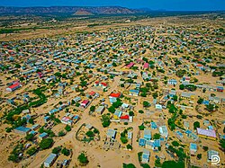
879:
878:
872:
862:
856:
855:
853:
852:
838:
829:
828:
826:
825:
819:UNHCR statistics
811:
805:
804:
799:
798:
792:
782:
776:
775:
767:
749:
744:
743:
742:
394:
388:mountain climate
364:hamadryas baboon
171:
169:
168:
154:
153:
151:
150:
149:
144:
140:
137:
136:
135:
132:
115:
101:
100:
94:
82:
68:
67:
61:
47:
26:
19:
978:
977:
973:
972:
971:
969:
968:
967:
953:
952:
944:
939:
938:
928:
926:
922:
921:
917:
905:
903:
899:
893:
892:
888:
876:
874:
870:
864:
863:
859:
850:
848:
840:
839:
832:
823:
821:
813:
812:
808:
796:
794:
790:
784:
783:
779:
770:
768:
761:
756:
745:
740:
738:
735:
724:
719:
714:
709:
704:
699:
694:
689:
684:
679:
674:
669:
664:
650:
645:
640:
635:
630:
625:
620:
615:
610:
605:
600:
595:
590:
580:
575:
570:
565:
560:
555:
550:
545:
540:
535:
530:
525:
520:
510:
505:
500:
495:
490:
485:
480:
475:
470:
465:
460:
455:
450:
372:
344:
302:
254:
166:
164:
147:
145:
141:
138:
133:
130:
128:
126:
125:
119:
118:
117:
116:
113:
112:
109:
108:
107:
106:
102:
85:
84:
83:
80:
79:
76:
75:
74:
73:
69:
38:
31:
24:
17:
12:
11:
5:
976:
974:
966:
965:
955:
954:
951:
950:
943:
940:
937:
936:
915:
886:
857:
830:
806:
777:
758:
757:
755:
752:
751:
750:
732:
731:
727:
726:
721:
716:
711:
706:
701:
696:
691:
686:
681:
676:
671:
666:
661:
653:
652:
647:
642:
637:
632:
627:
622:
617:
612:
607:
602:
597:
592:
587:
583:
582:
577:
572:
567:
562:
557:
552:
547:
542:
537:
532:
527:
522:
517:
513:
512:
507:
502:
497:
492:
487:
482:
477:
472:
467:
462:
457:
452:
447:
443:
442:
439:
436:
433:
430:
427:
424:
421:
418:
415:
412:
409:
406:
403:
399:
398:
392:
371:
368:
356:dorcas gazelle
343:
340:
301:
298:
253:
250:
217:
216:
206:
200:
199:
194:
188:
187:
182:
176:
175:
162:
156:
155:
121:
120:
110:
104:
103:
96:
95:
89:
88:
87:
86:
77:
71:
70:
63:
62:
56:
55:
54:
53:
52:
49:
48:
40:
39:
36:
33:
32:
25:
22:
15:
13:
10:
9:
6:
4:
3:
2:
975:
964:
961:
960:
958:
949:
946:
945:
941:
925:
919:
916:
912:
898:
897:
890:
887:
883:
869:
868:
861:
858:
847:
843:
837:
835:
831:
820:
816:
810:
807:
803:
789:
788:
781:
778:
773:
766:
764:
760:
753:
748:
737:
728:
722:
717:
712:
707:
702:
697:
692:
687:
682:
677:
672:
667:
662:
659:
658:precipitation
654:
648:
643:
638:
633:
628:
623:
618:
613:
608:
603:
598:
593:
588:
584:
578:
573:
568:
563:
558:
553:
548:
543:
538:
533:
528:
523:
518:
514:
508:
503:
498:
493:
488:
483:
478:
473:
468:
463:
458:
453:
448:
444:
400:
395:
391:
389:
385:
381:
377:
369:
367:
365:
361:
357:
353:
349:
341:
338:
334:
332:
328:
324:
319:
317:
314:
310:
307:
299:
297:
295:
291:
287:
286:Makayl-Dheere
283:
275:
270:
263:
258:
251:
249:
247:
243:
239:
235:
231:
227:
223:
214:
210:
207:
205:
198:
195:
193:
186:
183:
181:
174:
163:
161:
152:
124:Coordinates:
93:
60:
46:
34:
29:
20:
927:. Retrieved
918:
910:
904:. Retrieved
895:
889:
881:
875:. Retrieved
866:
860:
849:. Retrieved
845:
822:. Retrieved
818:
809:
801:
795:. Retrieved
786:
780:
660:mm (inches)
386:). It has a
383:
373:
345:
336:
320:
303:
300:Demographics
279:
221:
220:
27:
276:in Harirad.
146: /
942:References
906:2020-02-03
877:2020-02-03
851:2012-02-08
824:2012-02-08
797:2020-02-03
323:Gadabuursi
306:Gadabuursi
294:Gadabuursi
290:Gadabuursi
274:Gadabuursi
262:Gadabuursi
238:Somaliland
236:region of
173:Somaliland
134:42°50′00″E
131:10°27′00″N
376:semi-arid
348:highlands
342:Geography
204:Time zone
957:Category
656:Average
331:Ethiopia
246:Ethiopia
230:Xariirad
222:Harirad
192:District
28:Xariirad
774:. 1993.
725:(13.5)
651:(66.4)
646:(58.1)
641:(60.6)
636:(65.3)
631:(72.1)
626:(71.8)
621:(72.7)
616:(74.5)
611:(71.1)
606:(67.8)
601:(64.2)
596:(60.6)
591:(57.6)
581:(76.7)
576:(69.1)
571:(72.0)
566:(76.3)
561:(81.5)
556:(81.9)
551:(82.9)
546:(84.4)
541:(81.1)
536:(77.4)
531:(74.5)
526:(70.7)
521:(68.9)
511:(87.2)
506:(80.2)
501:(83.3)
496:(87.3)
491:(91.0)
486:(92.1)
481:(93.2)
476:(94.5)
471:(91.2)
466:(87.1)
461:(84.9)
456:(81.0)
451:(80.2)
370:Climate
360:caracal
252:History
160:Country
105:Harirad
72:Harirad
23:Harirad
720:(0.1)
715:(0.4)
710:(0.5)
705:(2.0)
700:(2.8)
695:(1.9)
690:(0.6)
685:(1.2)
680:(2.0)
675:(1.0)
670:(0.6)
665:(0.4)
402:Month
242:Borama
226:Somali
180:Region
170:
929:6 May
900:(PDF)
871:(PDF)
791:(PDF)
754:Notes
441:Year
282:Zeila
264:clan.
234:Awdal
209:UTC+3
197:Zeila
185:Awdal
931:2013
649:19.1
644:14.5
639:15.9
634:18.5
629:22.3
624:22.1
619:22.6
614:23.6
609:21.7
604:19.9
599:17.9
594:15.9
589:14.2
579:24.8
574:20.6
569:22.2
564:24.6
559:27.5
554:27.7
549:28.3
544:29.1
539:27.3
534:25.2
529:23.6
524:21.5
519:20.5
509:30.7
504:26.8
499:28.5
494:30.7
489:32.8
484:33.4
479:34.0
474:34.7
469:32.9
464:30.6
459:29.4
454:27.2
449:26.8
438:Dec
435:Nov
432:Oct
429:Sep
426:Aug
423:Jul
420:Jun
417:May
414:Apr
411:Mar
408:Feb
405:Jan
327:Issa
313:Issa
37:Town
723:341
384:BSk
333::
316:Dir
309:Dir
213:EAT
959::
909:.
880:.
844:.
833:^
817:.
800:.
762:^
708:12
703:50
698:71
693:49
688:15
683:31
678:51
673:26
668:15
382::
362:,
358:,
354:,
296:.
228::
933:.
854:.
827:.
718:3
713:9
663:9
378:(
224:(
215:)
211:(
Text is available under the Creative Commons Attribution-ShareAlike License. Additional terms may apply.