108:
115:
29:
134:
198:
64:
245:
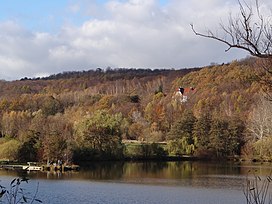
that was re-opened to tourists in 1986 after decades of decay and following major restoration. It is open when the flag is raised above its roof.
107:
273:
293:
57:
221:. It may be reached on various forest tracks and hiking trails that run through the Harly Forest - for example on the
278:
249:
298:
242:
182:
225:("ridgeway"). Almost exactly 2 kilometres southeast is the site of an old castle, the
202:
253:
209:), but this ignores the fact that there are other summits in that forested hill range.
151:
28:
287:
186:
178:
158:
127:
261:
257:
196:
Sometimes the term
Harlyberg is used as a synonym for the entire Harly Forest (
218:
173:
48:
79:
66:
226:
252:– one glazed and one open one – of the Harly Tower there are views of the
190:
139:
41:
279:
The Harly as part of the Harz-Brunswick Land-Eastphalia
Geopark
217:
The hill is located just under 2 kilometres northwest of
237:
On the summit of the
Harlyberg stands the Harly Tower (
150:
95:
56:
40:
35:
21:
8:
18:
7:
14:
274:Information about the Harly Tower
114:
132:
113:
106:
27:
181:, and rises in the district of
1:
177:, is the highest hill of the
172:255.9 m above
47:255.9 m above
16:Hill in Lower Saxony, Germany
315:
100:
26:
206:
294:Hills of Lower Saxony
260:to the north and the
250:observation platforms
80:51.96722°N 10.54361°E
76: /
256:to the south, the
85:51.96722; 10.54361
36:Highest point
243:observation tower
164:
163:
306:
201:
185:in southeastern
176:
154:
138:
136:
135:
117:
116:
110:
91:
90:
88:
87:
86:
81:
77:
74:
73:
72:
69:
51:
31:
19:
314:
313:
309:
308:
307:
305:
304:
303:
284:
283:
270:
235:
215:
197:
171:
152:
146:
145:
144:
143:
142:
133:
131:
125:
124:
123:
122:
118:
84:
82:
78:
75:
70:
67:
65:
63:
62:
46:
17:
12:
11:
5:
312:
310:
302:
301:
296:
286:
285:
282:
281:
276:
269:
268:External links
266:
254:Harz Mountains
234:
231:
214:
211:
174:sea level (NN)
162:
161:
156:
148:
147:
126:
120:
119:
112:
111:
105:
104:
103:
102:
101:
98:
97:
93:
92:
60:
54:
53:
49:sea level (NN)
44:
38:
37:
33:
32:
24:
23:
15:
13:
10:
9:
6:
4:
3:
2:
311:
300:
297:
295:
292:
291:
289:
280:
277:
275:
272:
271:
267:
265:
264:to the east.
263:
259:
255:
251:
246:
244:
240:
232:
230:
228:
224:
220:
212:
210:
208:
204:
200:
194:
192:
188:
184:
180:
175:
169:
160:
157:
155:
149:
141:
129:
109:
99:
94:
89:
61:
59:
55:
52:(840 ft)
50:
45:
43:
39:
34:
30:
25:
20:
247:
238:
236:
222:
216:
195:
187:Lower Saxony
179:Harly Forest
167:
165:
159:Harly Forest
153:Parent range
128:Lower Saxony
233:Harly Tower
83: /
58:Coordinates
299:Vienenburg
288:Categories
219:Vienenburg
207:Harly-Wald
189:, central
71:10°32′37″E
68:51°58′02″N
248:From the
239:Harlyturm
227:Harlyburg
213:Geography
199:‹See Tfd›
168:Harlyberg
121:Harlyberg
96:Geography
42:Elevation
22:Harlyberg
223:Kammweg
191:Germany
140:Germany
241:), an
203:German
183:Goslar
137:
170:, at
166:The
262:Huy
258:Elm
290::
229:.
205::
193:.
130:,
Text is available under the Creative Commons Attribution-ShareAlike License. Additional terms may apply.