459:
50:
499:
The 273 hectare site was sold by the
Department of Defence on behalf of the Commonwealth of Australia via a public tender process to Cedar Woods' wholly owned subsidiary Dunland Property Pty Ltd for $ 18,000,000 (bought for A$ 6.59 / m2, once developed residential sells at 700m2 for A$ 500,000 or A$
327:
The strategic location of the residential lots in
Hazelmere is considered by the City of Swan to be appropriate for higher density housing, and as a result a number of lots are currently under consideration for increased zoning. The rezoning of lots to the upper coding of R25 or R35 is considered
343:
The location of the lots that are proposed to be rezoned include the area generally bounded by
Bushmead Road, Stirling Crescent, Eric Street and Wingate Avenue. Also included are lots on the east side of Wingate Avenue, lots fronting Mary Street and Anthea Street and the freight rail line to the
303:
Formerly an extensive rural buffer between
Midland and the airport it now consists of a mix of residential land at the Guildford end, rural land in the center and industrial land to the east.
474:
165:
144:
894:
634:
288:
in 1829. When a
Guildford auctioneer bought the land in 1883, he subdivided the property into smaller lots, and one was named Hazelmere after the English town of
540:
889:
536:
Ordinary
Meeting of Council 25 September 2013 'Final Adoption LPS 17 Scheme Amendment 93 - Hazelmere Village Precinct'. Item 3.4 Attachment. Pdf document at
521:
132:
75:
517:
Ordinary
Meeting of Council 25 September 2013 'Final Adoption LPS 17 Scheme Amendment 93 - Hazelmere Village Precinct'. Item 3.4. Pdf document at
884:
478:
386:
369:
828:
693:
627:
220:
329:
458:
723:
416:
198:
753:
436:
319:
was sold in 2010 to property developer Cedar Woods
Properties Limited - more specifically its subsidy Dunlan Property Pty Ltd.
254:
225:
798:
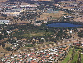
738:
673:
399:
382:
365:
333:
863:
843:
763:
758:
733:
708:
620:
230:
188:
156:
151:
853:
838:
833:
813:
793:
783:
773:
743:
718:
703:
678:
668:
269:
205:
68:
55:
823:
818:
713:
688:
316:
213:
597:
577:
557:
848:
808:
803:
698:
537:
337:
193:
17:
788:
728:
683:
663:
403:
518:
778:
768:
250:
36:
440:
328:
appropriate due to the location of the
Hazelmere lots that are located between 1 and 1.5 km from the
285:
122:
114:
612:
344:
west. The City of Swan have prepared two maps that show the current and proposed zoning respectively.
170:
652:
40:
505:
544:
525:
49:
878:
858:
273:
644:
336:
railway stations, and are within 2 km of the strategic metropolitan centre of
258:
137:
538:
http://www.swan.wa.gov.au/files/bd758b93-1b53-48aa-b892-a24600a3e91f/b3-4att.pdf
312:
265:
519:
http://www.swan.wa.gov.au/files/168dab92-9984-4da0-9310-a24600a3e806/b3-4.pdf
90:
77:
293:
289:
297:
648:
616:
477:. Western Australian Land Information Authority. Archived from
406:– serves Stirling Crescent, Robertson Street and West Parade
506:
http://www.cedarwoods.com.au/Investors/Announcements.aspx
284:
Hazelmere is part of the
Woodbridge land grant given to
311:The former Commonwealth-owned land of the Bushmead
272:to the south, Hazelmere is at the northern edge of
164:
143:
131:
121:
106:
67:
30:
502:14 May 2010 - Cedar Woods - Hazelmere Acquisition
177:
16:"Hazelmere" redirects here. For other uses, see
628:
315:that bordered on the formation of the former
8:
389:– serves Bushmead Road and Stirling Crescent
500:714 / m2), with settlement in July 2010 -
111:
895:Suburbs and localities in the City of Swan
635:
621:
613:
475:"History of metropolitan suburb names – H"
469:
467:
457:
48:
27:
253:, 14 kilometres (9 mi) east of the
428:
218:
203:
186:
179:
7:
890:Suburbs of Perth, Western Australia
25:Suburb of Perth, Western Australia
14:
445:Australian Census 2021 QuickStats
441:"Hazelmere (suburb and locality)"
417:Helena Valley, Western Australia
437:Australian Bureau of Statistics
255:Perth central business district
54:Hazelmere lakes in foreground,
1:
323:Rezoning of residential areas
885:Hazelmere, Western Australia
605:. Transperth. 24 July 2024 .
585:. Transperth. 11 July 2024 .
565:. Transperth. 11 July 2024 .
270:Great Eastern Highway Bypass
56:Great Eastern Highway Bypass
317:Upper Darling Range Railway
911:
18:Hazelmere (disambiguation)
15:
659:
236:
182:Suburbs around Hazelmere:
180:
176:
63:
47:
286:Captain James Stirling
372:– serves Midland Road
268:to the east, and the
387:High Wycombe Station
370:High Wycombe Station
307:Bushmead rifle range
543:31 May 2014 at the
524:31 May 2014 at the
166:Federal division(s)
145:State electorate(s)
87: /
91:31.901°S 115.922°E
872:
871:
653:Western Australia
599:Bus Timetable 111
579:Bus Timetable 110
559:Bus Timetable 110
404:Redcliffe Station
244:
243:
240:
239:
41:Western Australia
902:
637:
630:
623:
614:
607:
606:
604:
593:
587:
586:
584:
573:
567:
566:
564:
553:
547:
534:
528:
515:
509:
497:
491:
490:
488:
486:
481:on 16 March 2022
471:
462:
461:
455:
453:
451:
439:(28 June 2022).
433:
397:
395:
380:
378:
363:
361:
178:
113:
102:
101:
99:
98:
97:
96:-31.901; 115.922
92:
88:
85:
84:
83:
80:
52:
43:
33:
28:
910:
909:
905:
904:
903:
901:
900:
899:
875:
874:
873:
868:
829:South Guildford
694:Bennett Springs
655:
643:Suburbs of the
641:
611:
610:
602:
595:
594:
590:
582:
575:
574:
570:
562:
555:
554:
550:
545:Wayback Machine
535:
531:
526:Wayback Machine
516:
512:
498:
494:
484:
482:
473:
472:
465:
449:
447:
435:
434:
430:
425:
413:
400:Midland Station
393:
392:
383:Midland Station
376:
375:
366:Midland Station
359:
358:
355:
350:
325:
309:
282:
249:is a suburb of
221:South Guildford
95:
93:
89:
86:
81:
78:
76:
74:
73:
59:
35:
34:
31:
26:
21:
12:
11:
5:
908:
906:
898:
897:
892:
887:
877:
876:
870:
869:
867:
866:
861:
856:
851:
846:
841:
836:
831:
826:
821:
816:
811:
806:
801:
796:
791:
786:
781:
776:
771:
766:
761:
756:
751:
746:
741:
736:
731:
726:
721:
716:
711:
706:
701:
696:
691:
686:
681:
676:
671:
666:
660:
657:
656:
642:
640:
639:
632:
625:
617:
609:
608:
588:
568:
548:
529:
510:
492:
463:
427:
426:
424:
421:
420:
419:
412:
409:
408:
407:
390:
373:
354:
351:
349:
346:
334:East Guildford
324:
321:
308:
305:
281:
278:
242:
241:
238:
237:
234:
233:
228:
223:
217:
216:
211:
208:
202:
201:
196:
191:
185:
184:
174:
173:
168:
162:
161:
160:
159:
154:
147:
141:
140:
135:
129:
128:
125:
119:
118:
108:
104:
103:
71:
65:
64:
61:
60:
58:in upper right
53:
45:
44:
24:
13:
10:
9:
6:
4:
3:
2:
907:
896:
893:
891:
888:
886:
883:
882:
880:
865:
862:
860:
857:
855:
852:
850:
847:
845:
842:
840:
837:
835:
832:
830:
827:
825:
822:
820:
817:
815:
812:
810:
807:
805:
802:
800:
797:
795:
792:
790:
787:
785:
782:
780:
777:
775:
772:
770:
767:
765:
762:
760:
757:
755:
752:
750:
747:
745:
742:
740:
737:
735:
732:
730:
727:
725:
724:Cullacabardee
722:
720:
717:
715:
712:
710:
707:
705:
702:
700:
697:
695:
692:
690:
687:
685:
682:
680:
677:
675:
672:
670:
667:
665:
662:
661:
658:
654:
650:
646:
638:
633:
631:
626:
624:
619:
618:
615:
601:
600:
596:"Route 291".
592:
589:
581:
580:
576:"Route 278".
572:
569:
561:
560:
556:"Route 277".
552:
549:
546:
542:
539:
533:
530:
527:
523:
520:
514:
511:
507:
503:
496:
493:
480:
476:
470:
468:
464:
460:
446:
442:
438:
432:
429:
422:
418:
415:
414:
410:
405:
401:
391:
388:
384:
374:
371:
367:
357:
356:
352:
347:
345:
341:
339:
335:
331:
322:
320:
318:
314:
306:
304:
301:
299:
295:
291:
287:
279:
277:
275:
274:Perth Airport
271:
267:
262:
260:
256:
252:
248:
235:
232:
229:
227:
224:
222:
219:
215:
212:
209:
207:
204:
200:
199:Helena Valley
197:
195:
192:
190:
187:
183:
175:
172:
169:
167:
163:
158:
155:
153:
150:
149:
148:
146:
142:
139:
136:
134:
130:
126:
124:
120:
116:
109:
105:
100:
72:
70:
66:
62:
57:
51:
46:
42:
38:
29:
23:
19:
754:Henley Brook
748:
645:City of Swan
598:
591:
578:
571:
558:
551:
532:
513:
501:
495:
483:. Retrieved
479:the original
448:. Retrieved
444:
431:
342:
326:
310:
302:
283:
264:Bordered by
263:
259:City of Swan
246:
245:
226:High Wycombe
181:
138:City of Swan
22:
799:Middle Swan
739:Gidgegannup
674:Baskerville
485:23 February
313:rifle range
266:Roe Highway
123:Postcode(s)
94: /
82:115°55′19″E
69:Coordinates
879:Categories
864:Woodbridge
844:Upper Swan
764:Jane Brook
759:Herne Hill
734:Ellenbrook
709:Bullsbrook
330:Woodbridge
231:Maida Vale
189:Woodbridge
107:Population
79:31°54′04″S
854:West Swan
839:The Vines
834:Swan View
814:Millendon
794:Melaleuca
784:Lockridge
774:Koongamia
749:Hazelmere
744:Guildford
719:Caversham
704:Brigadoon
679:Beechboro
669:Ballajura
348:Transport
294:Guildford
290:Haslemere
257:, in the
247:Hazelmere
210:Hazelmere
206:Guildford
32:Hazelmere
859:Whiteman
824:Stratton
819:Red Hill
714:Bushmead
689:Bellevue
541:Archived
522:Archived
411:See also
214:Bushmead
849:Viveash
809:Midvale
804:Midland
699:Brabham
450:28 June
338:Midland
280:History
194:Midland
171:Hasluck
157:Midland
152:Belmont
39:,
789:Malaga
729:Dayton
684:Belhus
664:Aveley
456:
396:
394:
379:
377:
362:
360:
298:Surrey
276:land.
133:LGA(s)
779:Lexia
769:Kiara
649:Perth
603:(PDF)
583:(PDF)
563:(PDF)
423:Notes
292:near
251:Perth
110:935 (
37:Perth
487:2008
452:2022
398:291
381:278
364:277
332:and
127:6055
115:2021
504:at
402:to
385:to
368:to
353:Bus
112:SAL
881::
651:,
647:,
466:^
443:.
340:.
300:.
296:,
261:.
636:e
629:t
622:v
508:.
489:.
454:.
117:)
20:.
Text is available under the Creative Commons Attribution-ShareAlike License. Additional terms may apply.