26:
203:
506:
188:. The northern half of the trail has some parallel trackway for snowmobiles. A 4-mile (6.4 km) segment north of Walker traverses very hilly terrain to appeal to snowmobilers; other users can follow a marked alternate route on paved road shoulders.
727:
195:
in 1974, the
Heartland State Trail is one of the state's oldest rail trails. A westward extension was approved in 2006 to run 85–100 miles (137–161 km) from Park Rapids to
722:
405:
742:
206:
The official start of the
Heartland Trail is at Park Rapids’ Heartland Park, which has shelters, restrooms, a swimming beach and a bridge across the Fish Hook River.
717:
737:
351:
398:
537:
465:
414:
732:
691:
25:
475:
391:
712:
653:
121:
58:
615:
485:
202:
648:
290:
600:
542:
450:
430:
668:
638:
605:
490:
460:
110:
567:
314:
226:
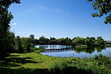
to Cass Lake. The trail connects the communities of Park Rapids, Dorset, Nevis, Akeley, Walker and Cass Lake.
686:
620:
562:
547:
173:
663:
264:
165:
70:
577:
522:
192:
582:
532:
169:
74:
643:
557:
455:
440:
196:
527:
343:
243:
144:
223:
219:
211:
177:
47:
658:
435:
215:
199:. This section is still in the planning stages and the exact route has not been finalized.
552:
480:
470:
185:
180:. The entire route is paved, with a parallel grass trackway along the southern half for
572:
495:
706:
181:
89:
131:
445:
84:
Biking, hiking, horseback riding, in-line skating, mountain biking, snowmobiling
157:
114:
383:
366:
353:
161:
65:
291:
Heartland State Trail
Extension: Park Rapids to Moorhead Master Plan
318:
505:
201:
387:
296:(Report). Minnesota Department of Natural Resources. June 2011
210:
The trail's current route runs from Park Rapids through
30:
The
Heartland State Trail leaving Park Rapids, Minnesota
272:(Map). Minnesota Department of Natural Resources. 2010
677:
629:
591:
513:
421:
140:
130:
120:
106:
98:
88:
80:
64:
54:
43:
35:
18:
246:. Minnesota Department of Natural Resources. 2011
399:
164:, USA. It runs 49 miles (79 km) between
8:
728:Protected areas of Hubbard County, Minnesota
406:
392:
384:
317:. City of Akeley Minnesota. Archived from
723:Protected areas of Cass County, Minnesota
743:National Recreation Trails in Minnesota
235:
15:
7:
718:Protected areas established in 1974
14:
738:1974 establishments in Minnesota
504:
476:Minnehaha Falls Lower Glen Trail
24:
1:
191:Established by an act of the
156:is a multi-use recreational
759:
415:Hiking trails in Minnesota
315:"City of Akeley Minnesota"
502:
367:47.1521778°N 94.6402556°W
23:
733:Rail trails in Minnesota
172:, intersecting with the
136:Asphalt, partial natural
111:Chippewa National Forest
372:47.1521778; -94.6402556
244:"Heartland State Trail"
174:Paul Bunyan State Trail
39:49 mi (79 km)
713:Minnesota state trails
207:
692:Sakatah Singing Hills
344:Heartland State Trail
266:Heartland State Trail
205:
193:Minnesota Legislature
154:Heartland State Trail
145:Heartland State Trail
59:Minnesota state trail
19:Heartland State Trail
616:Greater Grand Forks
363: /
321:on January 26, 2012
208:
700:
699:
654:Great River Ridge
160:in north-central
150:
149:
48:Central Minnesota
750:
508:
486:Minnesota Valley
436:Coldwater Spring
408:
401:
394:
385:
378:
377:
375:
374:
373:
368:
364:
361:
360:
359:
356:
331:
330:
328:
326:
311:
305:
304:
302:
301:
295:
287:
281:
280:
278:
277:
271:
261:
255:
254:
252:
251:
240:
182:horseback riding
28:
16:
758:
757:
753:
752:
751:
749:
748:
747:
703:
702:
701:
696:
673:
649:Goodhue Pioneer
625:
587:
509:
500:
481:Minnehaha Trail
417:
412:
381:
371:
369:
365:
362:
357:
354:
352:
350:
349:
340:
335:
334:
324:
322:
313:
312:
308:
299:
297:
293:
289:
288:
284:
275:
273:
269:
263:
262:
258:
249:
247:
242:
241:
237:
232:
186:mountain biking
73:
31:
12:
11:
5:
756:
754:
746:
745:
740:
735:
730:
725:
720:
715:
705:
704:
698:
697:
695:
694:
689:
683:
681:
675:
674:
672:
671:
666:
661:
656:
651:
646:
641:
635:
633:
627:
626:
624:
623:
618:
613:
608:
603:
597:
595:
589:
588:
586:
585:
580:
575:
570:
565:
560:
555:
550:
545:
543:Eagle Mountain
540:
535:
533:Cut Foot Sioux
530:
525:
519:
517:
511:
510:
503:
501:
499:
498:
496:Winchell Trail
493:
488:
483:
478:
473:
468:
463:
458:
453:
448:
443:
438:
433:
427:
425:
419:
418:
413:
411:
410:
403:
396:
388:
347:
346:
339:
338:External links
336:
333:
332:
306:
282:
256:
234:
233:
231:
228:
148:
147:
142:
138:
137:
134:
128:
127:
126:Severe weather
124:
118:
117:
108:
104:
103:
100:
96:
95:
92:
86:
85:
82:
78:
77:
68:
62:
61:
56:
52:
51:
45:
41:
40:
37:
33:
32:
29:
21:
20:
13:
10:
9:
6:
4:
3:
2:
755:
744:
741:
739:
736:
734:
731:
729:
726:
724:
721:
719:
716:
714:
711:
710:
708:
693:
690:
688:
685:
684:
682:
680:
676:
670:
669:Shooting Star
667:
665:
662:
660:
657:
655:
652:
650:
647:
645:
642:
640:
637:
636:
634:
632:
628:
622:
619:
617:
614:
612:
609:
607:
606:Central Lakes
604:
602:
599:
598:
596:
594:
590:
584:
581:
579:
576:
574:
571:
569:
568:Sioux–Hustler
566:
564:
561:
559:
558:North Country
556:
554:
551:
549:
546:
544:
541:
539:
536:
534:
531:
529:
526:
524:
521:
520:
518:
516:
512:
507:
497:
494:
492:
489:
487:
484:
482:
479:
477:
474:
472:
469:
467:
464:
462:
461:Glacial Lakes
459:
457:
454:
452:
449:
447:
444:
442:
441:Cannon Valley
439:
437:
434:
432:
429:
428:
426:
424:
423:Central/Metro
420:
416:
409:
404:
402:
397:
395:
390:
389:
386:
382:
379:
376:
358:94°38′24.92″W
345:
342:
341:
337:
320:
316:
310:
307:
292:
286:
283:
268:
267:
260:
257:
245:
239:
236:
229:
227:
225:
221:
217:
213:
204:
200:
198:
194:
189:
187:
183:
179:
175:
171:
167:
163:
159:
155:
146:
143:
139:
135:
133:
129:
125:
123:
119:
116:
112:
109:
105:
101:
97:
93:
91:
87:
83:
79:
76:
72:
69:
67:
63:
60:
57:
53:
49:
46:
42:
38:
34:
27:
22:
17:
678:
630:
610:
592:
538:Cuyuna Lakes
528:Border Route
514:
466:Hidden Falls
422:
380:
348:
323:. Retrieved
319:the original
309:
298:. Retrieved
285:
274:. Retrieved
265:
259:
248:. Retrieved
238:
209:
190:
153:
151:
94:Mostly level
687:Casey Jones
621:Paul Bunyan
563:North Shore
548:Gitchi-Gami
451:Dakota Rail
446:Crosby Farm
431:Bruce Vento
370: /
355:47°9′7.84″N
325:October 16,
166:Park Rapids
71:Park Rapids
55:Designation
707:Categories
664:Root River
659:Mill Towns
639:Big Rivers
491:Rush Creek
300:2011-06-18
276:2011-06-18
250:2011-06-18
230:References
158:rail trail
115:Leech Lake
102:Year-round
66:Trailheads
679:Southwest
631:Southeast
611:Heartland
593:Northwest
553:Kekekabic
523:Arrowhead
515:Northeast
471:Luce Line
170:Cass Lake
162:Minnesota
75:Cass Lake
583:Taconite
578:Superior
573:Snowbank
197:Moorhead
44:Location
644:Douglas
601:Agassiz
456:Gateway
176:around
141:Website
132:Surface
122:Hazards
224:Walker
222:, and
220:Akeley
212:Dorset
178:Walker
107:Sights
99:Season
36:Length
294:(PDF)
270:(PDF)
216:Nevis
90:Grade
50:, USA
327:2012
184:and
168:and
152:The
81:Use
709::
218:,
214:,
113:,
407:e
400:t
393:v
329:.
303:.
279:.
253:.
Text is available under the Creative Commons Attribution-ShareAlike License. Additional terms may apply.