39:
309:
317:
46:
1064:
1029:
408:, flowing east into Lowery Glacier from the northeast slopes of the Queen Elizabeth Range. Mapped by the USGS from tellurometer surveys and Navy air photos, 1960-62. Named by US-ACAN for Egon Dorrer, USARP glaciologist on the Ross Ice Shelf 1962-63 and 1965-66.
450:
in the Queen
Elizabeth Range and flowing east into Lowery Glacier. Mapped by the USGS from tellurometer surveys and Navy air photos, 1960-62. Named by US-ACAN for Richard P. Heidemann, USARP glaciologist at Roosevelt Island, 1962-63. Not: Heindemann Glacier.
1068:
1033:
709:, flowing east into Lowery Glacier. Mapped by the USGS from tellurometer surveys and Navy air photos, 1960-62. Named by US-ACAN for Robert W. Rowland, USARP glaciologist at South Pole Station, 1962-63 and 1963-64.
624:
in the Queen
Elizabeth Range. Mapped by the USGS from tellurometer surveys and Navy air photos, 1960-62. Named by US-AC AN for Klemens J. Nottarp, USARP glaciologist on the Ross Ice Shelf, 1962-63 and 1965-66.
535:
in the Queen
Elizabeth Range and flows east for about 15 miles (24 km) to enter Lowery Glacier. Named by the northern party of the NZGSAE (1961-62) after the English county and the Dukedom of Kent.
300:, near the head of Lowery Glacier. So named by the NZGSAE (1959-60) because the feature is a natural barrier to sledge travel which the party was unable to traverse. Arai is the Maori term for barrier.
1100:
582:
to enter Lowery
Glacier. Named by US-ACAN for French Daniel Linehan, who made seismic soundings of ice thickness from the USS Atka, 1954-55, and in the Ross Sea area, 1955-56.
763:. Mapped by the USGS from tellurometer surveys and Navy air photos, 1960-62. Named by US-ACAN for Edward J. Oliver, USARP glaciologist at South Pole Station, 1961-62.
667:. Mapped by the USGS from tellurometer surveys and Navy air photos, 1960-62. Named by US-ACAN for Thomas L. Pavlak, USARP glaciologist at South Pole Station, 1962-63.
1093:
1128:
1086:
1109:
1037:
66:
176:
38:
819:. Named by the expedition after Murray Robb, leader of the NZGSAE (1959-60), who traversed this glacier to reach Lowery Glacier.
493:, in the Queen Elizabeth Range. Named for Arthur S. Helm, former Secretary of the Ross Sea Committee, by the NZGSAE (1961-62).
1072:
366:, to enter Lowery Glacier. Named by the Northern Party of NZGSAE (1961-62) after the English County and Dukedom of Cornwall.
59:
779:
727:
677:
635:
592:
546:
503:
461:
418:
376:
334:
268:
123:
1133:
223:
575:
172:
250:
1044:
308:
245:
756:
363:
195:
663:. A glacier that drains east from the Queen Elizabeth Range into Lowery Glacier close south of
316:
240:
194:
It was named by the New
Zealand Geological and Topographical Survey Expedition (1959–60) for
579:
532:
489:. Glacier 15 miles (24 km) long, flowing north to enter Lowery Glacier just west of
812:
664:
180:
160:
156:
109:
1122:
808:
706:
490:
297:
207:
1011:
772:
760:
405:
188:
184:
1078:
816:
621:
447:
362:. A glacier in the Queen Elizabeth Range, draining eastward, to the south of
235:
794:
781:
742:
729:
692:
679:
650:
637:
607:
594:
561:
548:
518:
505:
476:
463:
433:
420:
391:
378:
349:
336:
283:
270:
138:
125:
81:
68:
17:
203:
446:. Glacier, 5 miles (8.0 km) long, originating close northwest of
199:
152:
620:. Small glacier draining eastward into Lowery Glacier just south of
296:. A series of crevassed terraces and icefalls close southward of
574:. A glacier, 11 miles (18 km) long, flowing northeast from
1082:
155:
about 60 nautical miles (110 km) long, a tributary of the
807:. A glacier about 40 miles (64 km) long, flowing from
198:
who, as a member of a field party, suffered injuries when a
833:
831:
320:
Queen
Elizabeth Range and upper Lowery Glacier (east)
1019:(2 ed.), United States Board on Geographic Names
717:
Tributaries entering from the right (east) include:
324:Tributaries entering from the left (west) include:
105:
97:
58:
187:, but the two glaciers separate when they reach
849:
759:and entering Lowery Glacier just north of the
312:Nimrod Glacier and lower Lowery Glacier (east)
1094:
8:
755:Glacier draining the area west and south of
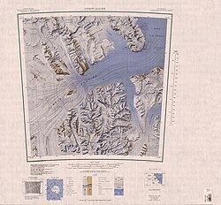
1101:
1087:
1079:
29:
531:. Glacier which drains the east side of
179:to enter Nimrod Glacier. To the north of
175:, Antarctica, along the east side of the
315:
307:
1038:United States Board on Geographic Names
993:
981:
969:
957:
945:
933:
921:
909:
897:
885:
873:
861:
837:
827:
45:
7:
705:. Glacier on the north side of the
171:The Lowery Glacier flows north from
1071:from websites or documents of the
1036:from websites or documents of the
25:
1013:Geographic Names of the Antarctic
1067: This article incorporates
1062:
1032: This article incorporates
1027:
44:
37:
1129:Glaciers of the Ross Dependency
1110:Glaciers of the Ross Dependency
1073:United States Geological Survey
159:, which enters the west of the
1010:Alberts, Fred G., ed. (1995),
1:
811:north along the east side of
251:GPX (secondary coordinates)
101:110 kilometres (68 mi)
1150:
770:
815:to the Ross Ice Shelf at
404:. Glacier just south of
246:GPX (primary coordinates)
221:Map all coordinates using
32:
578:along the north side of
229:Download coordinates as:
1069:public domain material
1034:public domain material
321:
313:
576:Prince Andrew Plateau
319:
311:
241:GPX (all coordinates)
177:Queen Elizabeth Range
173:Prince Andrew Plateau
27:Glacier in Antarctica
850:Nimrod Glacier USGS
791: /
739: /
689: /
647: /
604: /
558: /
515: /
473: /
430: /
388: /
346: /
280: /
135: /
78: /
795:82.633°S 165.000°E
757:Mount Christchurch
743:82.567°S 163.750°E
693:82.767°S 163.167°E
651:82.967°S 163.200°E
608:82.617°S 162.900°E
562:83.250°S 162.683°E
519:82.833°S 163.167°E
477:83.117°S 162.500°E
434:82.550°S 162.833°E
392:82.683°S 163.083°E
364:Crowell Buttresses
350:83.067°S 162.333°E
322:
314:
284:83.200°S 163.600°E
210:in November 1959.
183:it converges with
139:82.583°S 163.250°E
82:82.583°S 163.250°E
1116:
1115:
713:Right tributaries
412:Heidemann Glacier
115:
114:
16:(Redirected from
1141:
1134:Shackleton Coast
1103:
1096:
1089:
1080:
1066:
1065:
1056:
1055:
1054:
1031:
1030:
1026:
1025:
1024:
1018:
997:
991:
985:
979:
973:
967:
961:
955:
949:
943:
937:
931:
925:
919:
913:
907:
901:
895:
889:
883:
877:
871:
865:
859:
853:
847:
841:
835:
806:
805:
803:
802:
801:
800:-82.633; 165.000
796:
792:
789:
788:
787:
784:
754:
753:
751:
750:
749:
748:-82.567; 163.750
744:
740:
737:
736:
735:
732:
704:
703:
701:
700:
699:
698:-82.767; 163.167
694:
690:
687:
686:
685:
682:
662:
661:
659:
658:
657:
656:-82.967; 163.200
652:
648:
645:
644:
643:
640:
619:
618:
616:
615:
614:
613:-82.617; 162.900
609:
605:
602:
601:
600:
597:
573:
572:
570:
569:
568:
567:-83.250; 162.683
563:
559:
556:
555:
554:
551:
530:
529:
527:
526:
525:
524:-82.833; 163.167
520:
516:
513:
512:
511:
508:
488:
487:
485:
484:
483:
482:-83.117; 162.500
478:
474:
471:
470:
469:
466:
445:
444:
442:
441:
440:
439:-82.550; 162.833
435:
431:
428:
427:
426:
423:
403:
402:
400:
399:
398:
397:-82.683; 163.083
393:
389:
386:
385:
384:
381:
361:
360:
358:
357:
356:
355:-83.067; 162.333
351:
347:
344:
343:
342:
339:
328:Cornwall Glacier
304:Left tributaries
295:
294:
292:
291:
290:
289:-83.200; 163.600
285:
281:
278:
277:
276:
273:
202:broke through a
150:
149:
147:
146:
145:
144:-82.583; 163.250
140:
136:
133:
132:
131:
128:
93:
92:
90:
89:
88:
87:-82.583; 163.250
83:
79:
76:
75:
74:
71:
48:
47:
41:
30:
21:
1149:
1148:
1144:
1143:
1142:
1140:
1139:
1138:
1119:
1118:
1117:
1112:
1107:
1063:
1059:
1052:
1050:
1043:
1028:
1022:
1020:
1016:
1009:
1005:
1000:
992:
988:
980:
976:
968:
964:
956:
952:
944:
940:
932:
928:
920:
916:
908:
904:
896:
892:
884:
880:
872:
868:
860:
856:
848:
844:
836:
829:
825:
799:
797:
793:
790:
785:
782:
780:
778:
777:
775:
769:
747:
745:
741:
738:
733:
730:
728:
726:
725:
723:
715:
697:
695:
691:
688:
683:
680:
678:
676:
675:
673:
671:Rowland Glacier
655:
653:
649:
646:
641:
638:
636:
634:
633:
631:
612:
610:
606:
603:
598:
595:
593:
591:
590:
588:
586:Nottarp Glacier
580:Turnabout Ridge
566:
564:
560:
557:
552:
549:
547:
545:
544:
542:
540:Linehan Glacier
533:Markham Plateau
523:
521:
517:
514:
509:
506:
504:
502:
501:
499:
481:
479:
475:
472:
467:
464:
462:
460:
459:
457:
438:
436:
432:
429:
424:
421:
419:
417:
416:
414:
396:
394:
390:
387:
382:
379:
377:
375:
374:
372:
354:
352:
348:
345:
340:
337:
335:
333:
332:
330:
306:
288:
286:
282:
279:
274:
271:
269:
267:
266:
264:
259:
258:
257:
256:
255:
216:
169:
143:
141:
137:
134:
129:
126:
124:
122:
121:
86:
84:
80:
77:
72:
69:
67:
65:
64:
54:
53:
52:
51:
50:
49:
28:
23:
22:
15:
12:
11:
5:
1147:
1145:
1137:
1136:
1131:
1121:
1120:
1114:
1113:
1108:
1106:
1105:
1098:
1091:
1083:
1077:
1076:
1058:
1057:
1046:Nimrod Glacier
1041:
1006:
1004:
1001:
999:
998:
996:, p. 621.
986:
984:, p. 542.
974:
972:, p. 634.
962:
960:, p. 562.
950:
948:, p. 534.
938:
936:, p. 435.
926:
924:, p. 388.
914:
912:, p. 326.
902:
900:, p. 323.
890:
888:, p. 195.
878:
876:, p. 154.
866:
854:
842:
840:, p. 445.
826:
824:
821:
813:Softbed Ridges
771:Main article:
768:
765:
722:
721:Oliver Glacier
719:
714:
711:
672:
669:
665:Mount Predoehl
630:
629:Pavlak Glacier
627:
587:
584:
541:
538:
498:
495:
456:
453:
413:
410:
371:
370:Dorrer Glacier
368:
329:
326:
305:
302:
263:
260:
254:
253:
248:
243:
238:
232:
226:
219:
218:
217:
215:
212:
181:Softbed Ridges
168:
165:
163:, Antarctica.
161:Ross Ice Shelf
157:Nimrod Glacier
118:Lowery Glacier
113:
112:
110:Nimrod Glacier
107:
103:
102:
99:
95:
94:
62:
56:
55:
43:
42:
36:
35:
34:
33:
26:
24:
14:
13:
10:
9:
6:
4:
3:
2:
1146:
1135:
1132:
1130:
1127:
1126:
1124:
1111:
1104:
1099:
1097:
1092:
1090:
1085:
1084:
1081:
1074:
1070:
1061:
1060:
1048:
1047:
1042:
1039:
1035:
1015:
1014:
1008:
1007:
1002:
995:
990:
987:
983:
978:
975:
971:
966:
963:
959:
954:
951:
947:
942:
939:
935:
930:
927:
923:
918:
915:
911:
906:
903:
899:
894:
891:
887:
882:
879:
875:
870:
867:
864:, p. 24.
863:
858:
855:
851:
846:
843:
839:
834:
832:
828:
822:
820:
818:
814:
810:
809:Clarkson Peak
804:
774:
766:
764:
762:
758:
752:
720:
718:
712:
710:
708:
707:Frigate Range
702:
670:
668:
666:
660:
628:
626:
623:
617:
585:
583:
581:
577:
571:
539:
537:
534:
528:
496:
494:
492:
491:Fazekas Hills
486:
454:
452:
449:
443:
411:
409:
407:
401:
369:
367:
365:
359:
327:
325:
318:
310:
303:
301:
299:
298:Fazekas Hills
293:
262:Arai Terraces
261:
252:
249:
247:
244:
242:
239:
237:
234:
233:
231:
230:
225:
224:OpenStreetMap
222:
213:
211:
209:
208:Cape Selborne
205:
201:
197:
192:
190:
186:
182:
178:
174:
166:
164:
162:
158:
154:
148:
119:
111:
108:
104:
100:
96:
91:
63:
61:
57:
40:
31:
19:
1051:, retrieved
1045:
1021:, retrieved
1012:
994:Alberts 1995
989:
982:Alberts 1995
977:
970:Alberts 1995
965:
958:Alberts 1995
953:
946:Alberts 1995
941:
934:Alberts 1995
929:
922:Alberts 1995
917:
910:Alberts 1995
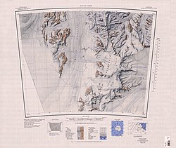
905:
898:Alberts 1995
893:
886:Alberts 1995
881:
874:Alberts 1995
869:
862:Alberts 1995
857:
845:
838:Alberts 1995
776:
773:Robb Glacier
767:Robb Glacier
761:Taylor Hills
724:
716:
674:
632:
589:
543:
500:
497:Kent Glacier
458:
455:Helm Glacier
415:
406:Mount Heiser
373:
331:
323:
265:
228:
227:
220:
193:
189:Taylor Hills
185:Robb Glacier
170:
117:
116:
18:Helm Glacier
817:Cape Goldie
798: /
746: /
696: /
654: /
611: /
565: /
522: /
480: /
437: /
395: /
353: /
287: /
206:bridge off
196:J.H. Lowery
142: /
85: /
60:Coordinates
1123:Categories
1053:2023-12-22
1023:2023-12-03
823:References
622:Mount Damm
448:Mount Damm
786:165°00′E
734:163°45′E
684:163°10′E
642:163°12′E
599:162°54′E
553:162°41′E
510:163°10′E
468:162°30′E
425:162°50′E
383:163°05′E
341:162°20′E
275:163°36′E
214:Icefalls
204:crevasse
167:Location
130:163°15′E
106:Terminus
73:163°15′E
1003:Sources
783:82°38′S
731:82°34′S
681:82°46′S
639:82°58′S
596:82°37′S
550:83°15′S
507:82°50′S
465:83°07′S
422:82°33′S
380:82°41′S
338:83°04′S
272:83°12′S
200:Sno-cat
153:glacier
151:) is a
127:82°35′S
70:82°35′S
1049:, USGS
98:Length
1017:(PDF)
236:KML
1125::
830:^
191:.
1102:e
1095:t
1088:v
1075:.
1040:.
852:.
120:(
20:)
Text is available under the Creative Commons Attribution-ShareAlike License. Additional terms may apply.