661:
336:
653:
33:
613:, paramount chief of Waiohua, led a surprise attack in the south Kaipara during an uhunga (funeral rite commemoration), in response for past grievances and to assist a Ngāti Whātua faction who were opposed to Te Taoū. Kiwi Tāmaki's party pursued the survivors south to the pā at Te Mākiri (Te Awaroa / Helensville), confronting Tuperiri and Waha-akiaki, two prominent members of Te Taoū who managed to survive. By 1741, Ngāti Whātua had successfully fought against
3517:
1015:
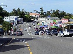
771:, was established in 1900, becoming a major part of life at Helensville, and drawing people from the surrounding areas to the town. In 1911, the Kaipara Dairy Company was established in Helensville, becoming the town's largest employer, and the town flourished due to the dairy industry and sheep farms. Additionally, tourists were drawn to Helensville in the early 20th century, due to the
673:
3534:
354:. The town is located between two tributaries of the river: the Awaroa Stream to the north, and the Mangakura Stream in the south. The town is located on a spur in the hills slightly higher than the surrounding area, of which the highest point is a 182 m (597 ft) hill located to the south called Paehoka, at the junction between Kiwitahi Road and Old North Road.
3500:
888:. There were 993 households, comprising 1,413 males and 1,377 females, giving a sex ratio of 1.03 males per female. The median age was 36.7 years (compared with 37.4 years nationally), with 642 people (23.0%) aged under 15 years, 507 (18.2%) aged 15 to 29, 1,221 (43.8%) aged 30 to 64, and 417 (15.0%) aged 65 or older.
989:. There were 498 households, comprising 771 males and 753 females, giving a sex ratio of 1.02 males per female. The median age was 42.4 years (compared with 37.4 years nationally), with 306 people (20.1%) aged under 15 years, 264 (17.3%) aged 15 to 29, 771 (50.6%) aged 30 to 64, and 183 (12.0%) aged 65 or older.
1005:
Of those at least 15 years old, 225 (18.5%) people had a bachelor's or higher degree, and 195 (16.0%) people had no formal qualifications. The median income was $ 40,100, compared with $ 31,800 nationally. 300 people (24.6%) earned over $ 70,000 compared to 17.2% nationally. The employment status of
904:
Of those at least 15 years old, 330 (15.4%) people had a bachelor's or higher degree, and 435 (20.3%) people had no formal qualifications. The median income was $ 31,600, compared with $ 31,800 nationally. 339 people (15.8%) earned over $ 70,000 compared to 17.2% nationally. The employment status of
715:
collection. In 1865, the road from
Riverhead to Helensville was improved, and pastoral farms were developed in the 1870s. By 1870, Helensville had become the main trading centre and transportation junction for the Kaipara Harbour settlements to the north. From 1875 to 1881, a short-lived section of
703:
timber mill on the eastern banks of the
Kaipara River, at the modern-day site of Helensville. McLeod named his house "Helen's Villa", after his wife, which became the name for the township that developed around the timber mill. McLeod milled the kauri on the lands adjacent to his timber mill, and
1066:
Below is a list of the 18 people who served as the chairman of the
Helensville Town Board, the longest of whom was Charles S. West, who served from 1922 to 1924, and again from 1929 to 1938. The final chairman, Reg Screaton, became the first Mayors of the Helensville Borough in 1947.
1031:, a large rural county north and west of the city of Auckland. In 1883, the Helensville Town Board was formed to administer the area, within the Waitemata County. In 1947, Helensville split from the country to form an independent borough. In 1989, the borough merged with
1782:
573:
warrior from Kawhia. Kāwharu's repeated attacks of the Waitākere Ranges settlements became known as Te
Raupatu Tīhore, or the stripping conquest. Lasting peace between Te Kawerau ā Maki and Ngāti Whātua was forged by Maki's grandson Te Au o Te Whenua, who fixed the
797:
The dairy factory closed in the late 1980s, due to a decline in farming profitability in the area. The sand extraction industry became a major employer in the town, after Mt Rex and
Winstone established processing facilities near the town in the 1990s.
1282:
Formerly a forestry or dairy centre, Helensville is increasingly becoming a dormitory suburb of
Auckland with an increasing number of lifestyle blocks in the area. There is some economic benefit from the wine producing region around
357:
The area has traditionally been a wetland and flood plain for the
Kaipara River, until the late 19th century when the Kaipara River catchment was developed into farmland. Historically, the hills to the east of Helensville were a
1793:
530:. Over 18 pā sites can be found in the Helensville area, which likely represent some of the earliest fortified pā in Auckland. Ōtakanini pā, located near Parkhurst northwest of Helensville, has been dated to at least 1400AD.
2345:
754:
individuated collectively-owned Ngāti Whātua lands, a gradual process which led to land alienation. By 1900, almost the entire southern
Kaipara area had been alienated from Ngāti Whātua, and only 10% of their traditional
316:
The name
Helensville comes from early settler John McLeod, and is a version of Helen's Villa, his house, that he named after his wife Helen Alexander. The first known references in print to Helensville date to 1863. The
3129:
565:, primarily on the waka Te Potae o Wahieroa and Te Wharau. Initially relations between the iwi were friendly, and many important marriages were made. Hostilities broke out and Ngāti Whātua asked for assistance from
913:
Helensville Rural statistical area surrounds the settlement and covers 56.41 km (21.78 sq mi). It had an estimated population of 1,680 as of June 2023, with a population density of 30 people per km.
2242:
1636:
549:; a name that references the kūmara incident. Maki chose the southern Kaipara as his base of operations, and his children migrated to different areas of the northern and western Auckland Region.
660:
3122:
977:
Before the 2023 census, Helensville Rural had a larger boundary, covering 56.92 km (21.98 sq mi). Using that boundary, Helensville Rural had a population of 1,524 at the
1324:
is a secondary (years 9–13) school with a roll of 765 as of August 2024. The school began as
Helensville District High School in 1924, and changed its name to Kaipara College in 1959.
308:
logging settlement in 1862, developing into a regional centre for the south Kaipara by the 1870s. Helensville became a major centre for the dairy industry between 1911 and the 1980s.
739:
In 1879, St Matthew's Anglican Church was established in Helensville. This was the first church in the wider southern Kaipara area, serving the surrounding rural communities such as
3115:
3569:
533:
By the mid-17th century, Ngāti Awa and Ngā Oho struggled to control territory. A descendant of Tītahi, Hauparoa, asked his relative Maki, a renowned warrior who lived at the
876:
Before the 2023 census, Helensville had a smaller boundary, covering 3.37 km (1.30 sq mi). Using that boundary, Helensville had a population of 2,787 at the
3564:
992:
Ethnicities were 93.7% European/Pākehā, 11.6% Māori, 3.0% Pacific peoples, 2.8% Asian, and 1.4% other ethnicities. People may identify with more than one ethnicity.
891:
Ethnicities were 84.6% European/Pākehā, 20.3% Māori, 7.6% Pacific peoples, 4.2% Asian, and 1.3% other ethnicities. People may identify with more than one ethnicity.
3579:
813:
Helensville covers 4.05 km (1.56 sq mi) and had an estimated population of 3,330 as of June 2023, with a population density of 822 people per km.
3574:
2632:
628:
occurred at Paehoka, south of Helensville, likely in the late 18th century. Conflict continued through the early 19th century, and in 1818 English missionary
480:. Major settlements in the area were typically upland of the Kaipara River, due to the swampy ground immediately beside the river, and the Ohirangi wetlands (
2135:
2052:
3559:
1559:
692:
between 1853 and 1865, in part due to Ngāti Whātua's hope that this would lead to Europeans settlements developing and stimulate the economy of the area.
2567:
1920:
747:. In 1882, the first bridge across the Kaipara River was constructed at Te Horo Point, with the intention of this opening up farmland to the west.
1824:
998:
Although some people chose not to answer the census's question about religious affiliation, 61.6% had no religion, 28.3% were Christian, 0.8% had
897:
Although some people chose not to answer the census's question about religious affiliation, 56.3% had no religion, 30.2% were Christian, 2.0% had
2683:
2663:
2521:
335:
3488:
1974:
537:, to help Ngāti Awa secure the region. Maki conquered and unified many of the Tāmaki Māori tribes, including Ngā Oho of the south Kaipara and
47:
3063:
2799:
778:
In 1927, St Matthew's Anglican Church was rebuilt after a new larger church was required. During the 1930s, an exotic pine forest called the
542:
1945:
1260:
1884:
437:, who already lived in the area. Tāporapora was a fertile sandy land that gradually eroded west of the Okahukura Peninsula, of which
3086:
3044:
3021:
3002:
2976:
2713:
2444:
1829:
1695:
1670:
905:
those at least 15 was that 1,065 (49.7%) people were employed full-time, 327 (15.2%) were part-time, and 87 (4.1%) were unemployed.
1402:
728:. This led to increased economic activity in Helensville, which developed into a township and became an economic hub. In 1881, the
652:
1006:
those at least 15 was that 672 (55.2%) people were employed full-time, 180 (14.8%) were part-time, and 42 (3.4%) were unemployed.
3584:
656:
View of the Ngāti Whātua village adjacent to Helensville, with John McLeod's home, Helen's Villa, visible to the top-left (1863)
3506:
3342:
783:
644:(visible land occupation). Ngāti Whātua began returning to the Kaipara River from 1828, and were fully re-established by 1835.
523:
499:, which describes the meandering Kaipara River near Helensville, and further upstream near the Helensville Bridge was known as
1330:
Tau Te Arohanoa Akoranga is a satellite campus of the state-integrated Kingsway School, offering a Christian-based education.
1327:
Helensville Primary School is a full primary (years 1–8) school with a roll of 507 as of August 2024. It was founded in 1877.
2602:
2385:
2328:
89:
3397:
2078:
1302:
1760:
1719:
1598:
1502:
236:
3379:
417:
3386:
1372:
1341:
802:
767:
The Kauri logging and gum industries went into decline by 1900, disappearing by 1920. The Helensville Show, an annual
733:
3373:
3347:
2857:
1356:
1032:
538:
3201:
3139:
3074:
3032:
2701:
2316:
1047:
684:
was signed in 1840, Ngāti Whātua operated coastal trading vessels, supplying goods to early European settlers at
426:
413:
2688:
1359:
then transfer to another bus route 110 to central Auckland. At rush hours an express bus operates to Downtown.
791:
199:
79:
3322:
2900:
2461:
448:-dominated forests. Based on archaeological findings, many of the earliest people to come to the area caught
444:
People were drawn to the southern Kaipara Harbour due to its rich resources from the harbour and surrounding
327:, means "The Wide River", and is the name of a tributary stream that meets the Kaipara River at Helensville.
3436:
986:
982:
978:
885:
881:
877:
457:
453:
274:
270:
2842:
1432:
3470:
3196:
2668:
2607:
2528:
2517:
2389:
1952:
1566:
1555:
1436:
1310:
721:
689:
583:
429:
arriving at the Kaipara Harbour. Some of the crew members, including Rongomai, Mawete and Po, settled at
3402:
3392:
2000:
633:
422:
1264:
725:
546:
545:
from Hauparoa's storage pits, Maki attacked Ngāti Awa. Over time, Maki's descendants became known as
469:
286:
135:
3107:
1351:
With the cessation of the passenger train service the only public transport between Helensville and
3312:
1345:
1271:
751:
729:
632:
witnessed Ngāti Whātua of the Kaipara River being attacked from the north. Following the battle of
265:
in the 13th or 14th centuries, drawn by the marine and forest resources. The upper reaches of the
3423:
3236:
2152:
1523:
1051:
681:
114:
3337:
3252:
558:
509:
392:
298:
258:
32:
1892:
301:, who had traditional ties to the area, had re-established themselves along the Kaipara River.
3272:
3082:
3059:
3040:
3017:
2998:
2972:
2769:
2709:
2440:
2324:
2203:
2160:
2144:
1691:
1666:
999:
898:
768:
700:
606:
445:
359:
318:
305:
216:
566:
3418:
3332:
3327:
3317:
3221:
2759:
2352:
2249:
2195:
2168:
1789:
1352:
1040:
1028:
562:
438:
158:
3453:
3352:
3297:
3262:
1321:
1287:, 20 km to the south. The principal tourist attraction is the hot springs at nearby
1036:
1014:
779:
465:
388:
376:
351:
294:
282:
262:
232:
94:
2079:
Cultural Values Assessment for America's Cup 36 - Wynyard and Hobson Planning Application
383:
since around the 13th or 14th centuries. Māori legends describe supernatural beings, the
380:
3302:
3282:
3277:
3257:
2126:
1268:
629:
614:
610:
570:
534:
477:
434:
406:
to settled in the area are Te Tini o Maruiwi, who descend from Maruiwi, captain of the
140:
3031:
Paterson, Malcolm (2009). "Ko Ngā Kurī Purepure o Tāmaki, e Kore e Ngari i te Pō". In
901:, 0.9% were Hindu, 0.1% were Muslim, 0.6% were Buddhist and 2.3% had other religions.
3553:
3292:
3267:
2990:
2986:
2964:
2960:
1530:. Vol. XIX, no. 1919. 10 September 1863. p. 1 – via Papers Past.
665:
595:
473:
347:
340:
266:
252:
2130:
1466:
3287:
2199:
1915:
787:
672:
461:
384:
278:
224:
2562:
1149:
During the 42-year existence of Helensville Borough Council, it had eight mayors:
3523:
2934:
995:
The percentage of people born overseas was 21.7, compared with 27.1% nationally.
894:
The percentage of people born overseas was 17.8, compared with 27.1% nationally.
3428:
3307:
3211:
3176:
3147:
2820:
2637:
1819:
1368:
1306:
1055:
696:
625:
518:
244:
104:
2879:
3368:
2993:(1990). "Prehistoric Sites in West Auckland". In Northcote-Bade, James (ed.).
2186:
Bellwood, Peter (1972). "Excavations at Otakanini Pa, South Kaipara Harbour".
621:
591:
513:
2773:
2207:
2164:
2148:
1752:
1711:
1590:
1494:
640:, Ngāti Whātua fled the area, except for a small contingent who remained for
516:. Around the 15th century, a group known as Ngāti Awa who descended from the
62:
49:
712:
605:, the confederation of Tāmaki Māori tribes centred to the southeast, on the
2764:
2747:
705:
641:
430:
2172:
2001:
Māori Environmental Knowledge in Natural Hazards Management and Mitigation
3226:
3216:
3181:
3143:
1284:
744:
740:
717:
685:
617:, and members of Te Taoū established themselves on the Auckland isthmus.
408:
240:
228:
2156:
289:. By the 15th century, the area had become home to some of the earliest
3231:
3206:
3191:
3186:
2107:
Hayward, B.W. (1983). "Prehistoric pa sites of metropolitan Auckland".
1288:
931:
830:
772:
637:
602:
587:
579:
391:
is associated with the Tūrehu Tumutumuwhenua and his wife Kui, of whom
248:
3540:
3102:
2831:
387:, as being the inhabitants of the area prior to Māori settlement. The
3171:
3161:
2748:"The planning framework for Auckland 'super city': an insider's view"
1637:"TP146 Kaipara River Catchment Water Allocation Strategy 2001 Part B"
1002:, 0.2% were Muslim, 0.4% were Buddhist and 2.4% had other religions.
2912:
1916:"Canoe traditions - Canoes of the west coast and lower North Island"
227:
of New Zealand. It is sited 40 kilometres (25 mi) northwest of
452:. The southern Kaipara was an important transportation node due to
1013:
671:
659:
651:
541:. After an incident where Maki unsuccessfully asked a slave steal
527:
334:
290:
3073:
Taua, Te Warena (2009). "He Kohikohinga Kōrero mō Hikurangi". In
2686:. Statistics New Zealand. March 2020. Helensville Rural (112300).
1263:
general electorate. In 2020, this electorate was replaced by the
561:
tribes began returning to the southern Kaipara Harbour area from
526:, led by Tītahi. The iwi were prominent constructors of terraced
255:
runs through the town and into the Kaipara Harbour to the north.
2007:
1294:
Helensville has its own locally produced monthly newspaper, the
756:
688:. Large areas of the southern Kaipara harbour were purchased by
575:
3111:
2832:
Introducing North West Country | North West Country - Auckland
487:
449:
403:
396:
3482:
2462:"Names & Opening & Closing Dates of Railway Stations"
2225:
2223:
2221:
2219:
2217:
1427:
1425:
1423:
601:
Around the year 1740, war broke out between Ngāti Whātua and
2633:"Calls for rail to ease congestion in Auckland's north-west"
2284:
2282:
926:
825:
3014:
Doing It Themselves: the Story of Kumeu, Huapai and Taupaki
2729:
2727:
2725:
2666:. Statistics New Zealand. March 2020. Helensville (112400).
732:
was extended to Helensville, leading to the opening of the
1046:
Within the Auckland Council, Helensville is a part of the
1027:
From 1876 until 1947, Helensville was administered by the
2487:
2485:
1018:
The Helensville Town Board offices, pictured in the 1910s
3058:(4th ed.). Auckland: Longley Printing Company Ltd.
2269:
2267:
1631:
1629:
1627:
1625:
1623:
1621:
1619:
1617:
1615:
1058:, which elects one councillor to the Auckland Council.
251:
is two kilometres (1.2 mi) to the north-west. The
2852:
2850:
2437:
The Railways of New Zealand: A Journey through History
786:, becoming an important industry for the area. During
2969:
The Māori history and legends of the Waitākere Ranges
711:
The town grew based on the kauri timber industry and
247:
about 12 kilometres (7.5 mi) to the north-east.
2997:. West Auckland Historical Society. pp. 33–41.
2821:
Helensville News - Helensville's community newspaper
1781:
Pishief, Elizabeth; Shirley, Brendan (August 2015).
3462:
3446:
3411:
3361:
3245:
3154:
2882:. International Student Services Center Corporation
2563:"Auckland places - Kaipara Harbour and kauri towns"
346:Helensville is located on the eastern banks of the
198:
190:
182:
177:
169:
164:
154:
149:
128:
120:
110:
100:
88:
78:
23:
2522:Agreement in Principle to Settle Historical Claims
985:, and an increase of 315 people (26.1%) since the
884:, and an increase of 255 people (10.1%) since the
2678:
2676:
586:). Ngāti Whātua divided the land among different
2346:"Te Tātua a Riukiuta Three Kings Heritage Study"
817:Historical population for Helensville settlement
2700:Reidy, Jade (2009). "How the West Was Run". In
2053:"Te Kawerau ā Maki Deed of Settlement Schedule"
1549:
1547:
1545:
1543:
1541:
1539:
1537:
1039:. Rodney District Council was amalgamated into
416:, and migrated north into the Kaipara Harbour.
2658:
2656:
2372:
2300:
2039:
1301:The township is in the North West Country Inc
981:, an increase of 189 people (14.2%) since the
704:after a few years, Ngāti Whātua established a
3123:
3103:Helensville & District Historical Society
2323:. Auckland University Press. pp. 36–45.
1259:From 1978 until 2020, Helensville was in the
880:, an increase of 144 people (5.4%) since the
493:Known traditional names for the area include
243:16 kilometres (10 mi) to the south, and
8:
2901:Education Counts: Helensville Primary School
2689:2018 Census place summary: Helensville Rural
2684:"Statistical area 1 dataset for 2018 Census"
2664:"Statistical area 1 dataset for 2018 Census"
2435:Churchman, Geoffrey B; Hurst, Tony (2001) .
2136:Records of the Auckland Institute and Museum
1940:
1938:
1878:
1348:but the station has been closed since 2009.
917:
816:
3570:Populated places around the Kaipara Harbour
2439:(Second ed.). Transpress New Zealand.
2188:Journal of the Royal Society of New Zealand
1876:
1874:
1872:
1870:
1868:
1866:
1864:
1862:
1860:
1858:
918:Historical population for Helensville Rural
720:, south of Helensville, and the village of
500:
494:
481:
322:
3130:
3116:
3108:
2627:
2625:
2344:Pishief, Dr Elizabeth; Adam, John (2015).
2058:. New Zealand Government. 22 February 2014
1999:King, Darren NT; Goff, James (June 2006).
916:
815:
553:Return of Ngāti Whātua and the Musket Wars
399:of the harbour) consider to be ancestors.
239:passes through the town, connecting it to
20:
2786:
2763:
2733:
2503:
2422:
2410:
2229:
2027:
1849:
1739:
1461:
1459:
1457:
1455:
1453:
1145:Mayors of the Helensville Borough Council
231:, close to the southern extremity of the
2588:
2568:Te Ara - the Encyclopedia of New Zealand
2548:
2491:
2311:
2309:
2288:
1921:Te Ara - the Encyclopedia of New Zealand
1585:
1583:
1151:
339:Helensville on the eastern shore of the
3565:Populated places in the Auckland Region
3495:
1825:Te Ara: The Encyclopedia of New Zealand
1560:Deed of Settlement of Historical Claims
1385:
1305:zone which represents businesses from
197:
176:
163:
148:
127:
77:
42:
38:
29:
2669:2018 Census place summary: Helensville
1489:
1487:
1433:"Population estimate tables - NZ.Stat"
1397:
1395:
1393:
1391:
1389:
1267:electorate. Helensville is within the
1062:Chairmen of the Helensville Town Board
1050:local government area governed by the
620:An early skirmish between Te Taoū and
557:In the 17th and early 18th centuries,
3580:Populated places on the Kaipara River
3387:Helensville railway station (defunct)
1885:"Pre-European History - Ngati Whatua"
1712:"Place name detail: Mangakura Stream"
1333:All these schools are coeducational.
189:
181:
168:
153:
119:
109:
99:
87:
7:
3575:Populated places established in 1862
2273:
1355:is by buses to and from Westgate in
2860:. New Zealand Ministry of Education
2561:McClure, Margaret (5 August 2016).
2386:"Auckland: Conquerors and settlers"
1818:Taonui, Rāwiri (10 February 2015).
1688:The Geographic Atlas of New Zealand
805:was closed for passenger services.
173:4.05 km (1.56 sq mi)
3560:1862 establishments in New Zealand
2708:. Random House. pp. 238–239.
2603:"Search for sand turns to Kaipara"
2469:Rail Heritage Trust of New Zealand
1914:Taonui, Rāwiri (8 February 2005).
1591:"Place name detail: Awaroa Stream"
699:settler John McLeod established a
155: • Territorial Authority
14:
3437:Rodney District Council (defunct)
3380:Kumeu–Riverhead Section (defunct)
2995:West Auckland Remembers, Volume 1
2843:Education Counts: Kaipara College
2321:From Tamaki-makau-rau to Auckland
2086:Te Kawerau Iwi Tribunal Authority
1830:Ministry for Culture and Heritage
304:Helensville was established as a
3532:
3515:
3498:
3081:. Random House. pp. 23–48.
3039:. Random House. pp. 49–62.
2243:"Waitākere Ranges Heritage Area"
1973:Hamilton, Scott (21 July 2022).
1783:"Waikōwhai Coast Heritage Study"
1524:"Page 1 Advertisements Column 2"
1495:"Place name detail: Helensville"
594:, who were a major power in the
31:
3343:Te Korowai-o-Te-Tonga Peninsula
2858:"New Zealand Schools Directory"
2131:"Auckland Prehistory: A Review"
1686:Roger Smith, GeographX (2005).
784:Te Korowai-o-Te-Tonga Peninsula
664:View of Helensville beyond the
524:Te Korowai-o-Te-Tonga Peninsula
3079:West: The History of Waitakere
3037:West: The History of Waitakere
2706:West: The History of Waitakere
2200:10.1080/03036758.1972.10421818
2077:Mossman, Sarah (August 2018).
512:developed the tribal identity
18:Place in Auckland, New Zealand
1:
2800:"Timeline of Auckland mayors"
2601:Beston, Anne (6 April 2005).
1642:. Auckland City Council. 2001
1303:business improvement district
724:, on the upper shores of the
297:. By the early 18th century,
2915:. Helensville Primary School
2913:"Helensville Primary School"
1761:New Zealand Geographic Board
1753:"Place name detail: Paehoka"
1720:New Zealand Geographic Board
1599:New Zealand Geographic Board
1503:New Zealand Geographic Board
1247:
1236:
1225:
1214:
1203:
1192:
1181:
1170:
1092:1899–1902 Charles H. Spinley
1086:1894–1898 Charles H. Spinley
790:, the 15th Battalion of the
464:could be hauled between the
281:could be hauled between the
3398:Te Rau Pūriri Regional Park
3016:. Huapai-Kumeu Lions Club.
2802:. Auckland Council Archives
2516:Te Rūnanga o Ngāti Whātua;
1661:Peter Dowling, ed. (2004).
1375:Second World War flying ace
1373:Royal New Zealand Air Force
1342:Helensville railway station
803:Helensville railway station
750:Between 1865 and 1900, the
734:Helensville railway station
3601:
3374:Goldie Bush Scenic Reserve
3362:Facilities and attractions
3012:Dunsford, Deborah (2002).
2373:Diamond & Hayward 1979
2301:Diamond & Hayward 1979
2040:Diamond & Hayward 1990
1883:Kawharu, Margaret (2007).
1128:1938–1941 A. H. Brackebnsh
794:was based at Helensville.
763:Dairy industry and tourism
433:, with the descendants of
402:One of the earliest known
3054:Sheffield, C. M. (2011).
2880:"Kaipara College - ISSCC"
1690:. Robbie Burton. map 34.
1125:1929–1938 Charles S. West
1119:1922–1924 Charles S. West
970:
944:—
869:
843:—
716:railway operated between
676:Helensville shops ca 1890
194:820/km (2,100/sq mi)
43:
39:
30:
2935:"Head of School Welcome"
2746:Blakeley, Roger (2015).
1554:Ngāti Whātua o Kaipara;
1403:"ArcGIS Web Application"
1134:1941–1944 J. A. Stanaway
1131:1941–1941 Dr F. Matheson
1095:1902–1904 Alfred Becroft
1089:1898–1899 J. J. Reynolds
1083:1893–1894 Daniel Stewart
1077:1888–1890 Daniel Stewart
3585:Rodney Local Board Area
3348:Upper Waitematā Harbour
2460:Scoble, Juliet (2010).
1407:statsnz.maps.arcgis.com
1137:1944–1945 K. A. Snedden
1116:1918–1922 James Stewart
1113:1916–1918 J. T. Lambert
1104:1910–1912 James Stewart
1098:1904–1908 R. M. Cameron
1074:1886–1888 Henry Ballans
1037:Rodney District Council
1000:Māori religious beliefs
979:2018 New Zealand census
899:Māori religious beliefs
878:2018 New Zealand census
782:was established on the
708:on the opposite banks.
582:Beach and Rangitōpuni (
420:traditions tell of the
3471:Veronica jovellanoides
2971:. The Lodestar Press.
2765:10.26686/pq.v11i4.4572
2608:The New Zealand Herald
2529:New Zealand Government
2390:The New Zealand Herald
1953:Waitakere City Council
1665:. Reed Books. map 11.
1663:Reed New Zealand Atlas
1567:New Zealand Government
1437:Statistics New Zealand
1179:Herbert Onslow Strong
1140:1945–1947 Reg Screaton
1122:1924–1929 James Mackie
1107:1912–1914 James McLeod
1101:1908–1910 James McLeod
1080:1890–1893 James McLeod
1071:1883–1886 Isaac McLeod
1054:. It is a part of the
1019:
677:
669:
657:
501:
495:
482:
350:, to the south of the
343:
323:
220:
63:36.67972°S 174.44944°E
3487:at Knowledge (XXG)'s
3403:West Auckland Airport
3393:Muriwai Regional Park
3077:; Kerr, Ruth (eds.).
3035:; Kerr, Ruth (eds.).
2704:; Kerr, Ruth (eds.).
1757:New Zealand Gazetteer
1716:New Zealand Gazetteer
1595:New Zealand Gazetteer
1499:New Zealand Gazetteer
1467:"Helensville History"
1110:1914–1916 E. T. Field
1017:
675:
663:
655:
338:
261:settled the southern
3138:Kumeū Subdivision –
1558:(9 September 2011).
1528:Daily Southern Cross
1265:Kaipara ki Mahurangi
1201:Lionel M. T. Wotton
379:has been settled by
269:was the location of
191: • Density
136:Kaipara ki Mahurangi
68:-36.67972; 174.44944
3246:Geographic features
2789:, pp. 290–291.
2641:. 27 September 2016
1346:North Auckland Line
919:
818:
759:had been retained.
730:North Auckland Line
490:in ancient times).
412:, one of the first
362:-dominated forest.
223:) is a town in the
59: /
3424:Rodney Local Board
3323:Ōpāhekeheke Island
2520:(18 August 2017).
2127:Davidson, Janet M.
1975:"The Lost Islands"
1895:on 6 February 2021
1889:Helensville Museum
1799:on 5 February 2024
1052:Rodney Local Board
1043:in November 2010.
1020:
682:Treaty of Waitangi
678:
670:
658:
648:Early colonial era
486:were used to trap
423:Māhuhu-ki-te-rangi
344:
183: • Total
170: • Total
115:Rodney Local Board
3480:
3479:
3273:Kaukapakapa River
3075:Macdonald, Finlay
3065:978-0-473-18059-1
3056:Men Came Voyaging
3033:Macdonald, Finlay
2991:Hayward, Bruce W.
2965:Hayward, Bruce W.
2937:. Kingsway School
2702:Macdonald, Finlay
2291:, pp. 50–51.
2276:, pp. 34–35.
2232:, pp. 25–26.
2042:, pp. 38–39.
1979:North & South
1471:helensville.co.nz
1252:
1251:
975:
974:
874:
873:
775:thermal springs.
769:agricultural show
752:Native Land Court
726:Waitematā Harbour
634:Te Ika a Ranganui
578:(border) between
547:Te Kawerau ā Maki
470:Waitematā Harbour
287:Waitematā Harbour
210:
209:
124:Kumeū subdivision
3592:
3545:
3537:
3536:
3535:
3528:
3520:
3519:
3518:
3511:
3503:
3502:
3501:
3491:
3463:Related articles
3419:Auckland Council
3333:Riverhead Forest
3328:Ourauwhare River
3313:Ōkiritoto Stream
3222:Waikoukou Valley
3155:Populated places
3132:
3125:
3118:
3109:
3092:
3069:
3050:
3027:
3008:
2987:Diamond, John T.
2982:
2961:Diamond, John T.
2947:
2946:
2944:
2942:
2931:
2925:
2924:
2922:
2920:
2909:
2903:
2898:
2892:
2891:
2889:
2887:
2876:
2870:
2869:
2867:
2865:
2854:
2845:
2840:
2834:
2829:
2823:
2818:
2812:
2811:
2809:
2807:
2796:
2790:
2784:
2778:
2777:
2767:
2752:Policy Quarterly
2743:
2737:
2731:
2720:
2719:
2697:
2691:
2687:
2680:
2671:
2667:
2660:
2651:
2650:
2648:
2646:
2629:
2620:
2619:
2617:
2615:
2598:
2592:
2586:
2580:
2579:
2577:
2575:
2558:
2552:
2546:
2540:
2539:
2537:
2535:
2526:
2513:
2507:
2501:
2495:
2489:
2480:
2479:
2477:
2475:
2466:
2457:
2451:
2450:
2432:
2426:
2420:
2414:
2408:
2402:
2401:
2399:
2397:
2392:. 24 August 2010
2382:
2376:
2370:
2364:
2363:
2361:
2359:
2353:Auckland Council
2350:
2341:
2335:
2334:
2313:
2304:
2298:
2292:
2286:
2277:
2271:
2262:
2261:
2259:
2257:
2250:Auckland Council
2247:
2239:
2233:
2227:
2212:
2211:
2183:
2177:
2176:
2123:
2117:
2116:
2104:
2098:
2097:
2095:
2093:
2083:
2074:
2068:
2067:
2065:
2063:
2057:
2049:
2043:
2037:
2031:
2025:
2019:
2018:
2016:
2014:
2005:
1996:
1990:
1989:
1987:
1985:
1970:
1964:
1963:
1961:
1959:
1950:
1942:
1933:
1932:
1930:
1928:
1911:
1905:
1904:
1902:
1900:
1891:. Archived from
1880:
1853:
1847:
1841:
1840:
1838:
1836:
1815:
1809:
1808:
1806:
1804:
1798:
1792:. Archived from
1790:Auckland Council
1787:
1778:
1772:
1771:
1769:
1767:
1749:
1743:
1737:
1731:
1730:
1728:
1726:
1708:
1702:
1701:
1683:
1677:
1676:
1658:
1652:
1651:
1649:
1647:
1641:
1633:
1610:
1609:
1607:
1605:
1587:
1578:
1577:
1575:
1573:
1564:
1551:
1532:
1531:
1520:
1514:
1513:
1511:
1509:
1491:
1482:
1481:
1479:
1477:
1463:
1448:
1447:
1445:
1443:
1429:
1418:
1417:
1415:
1413:
1399:
1353:central Auckland
1296:Helensville News
1272:Māori electorate
1245:Eric J. Glavish
1234:George A. Smith
1190:Charles S. West
1152:
1041:Auckland Council
1029:Waitemata County
933:
928:
920:
832:
827:
819:
508:Over time, many
504:
502:Te Pu a Tangihua
498:
485:
439:Manukapua Island
395:(the modern-day
326:
237:State Highway 16
159:Auckland Council
74:
73:
71:
70:
69:
64:
60:
57:
56:
55:
52:
35:
21:
3600:
3599:
3595:
3594:
3593:
3591:
3590:
3589:
3550:
3549:
3548:
3538:
3533:
3531:
3527:from Wikivoyage
3521:
3516:
3514:
3504:
3499:
3497:
3494:
3490:sister projects
3489:
3481:
3476:
3458:
3454:Kaipara College
3442:
3407:
3357:
3353:Woodhill Forest
3338:Tāhekeroa River
3298:Moturemu Island
3263:Kaipara Harbour
3253:Arapārera River
3241:
3150:
3136:
3099:
3089:
3072:
3066:
3053:
3047:
3030:
3024:
3011:
3005:
2985:
2979:
2959:
2956:
2951:
2950:
2940:
2938:
2933:
2932:
2928:
2918:
2916:
2911:
2910:
2906:
2899:
2895:
2885:
2883:
2878:
2877:
2873:
2863:
2861:
2856:
2855:
2848:
2841:
2837:
2830:
2826:
2819:
2815:
2805:
2803:
2798:
2797:
2793:
2785:
2781:
2745:
2744:
2740:
2736:, pp. 290.
2732:
2723:
2716:
2699:
2698:
2694:
2682:
2681:
2674:
2662:
2661:
2654:
2644:
2642:
2631:
2630:
2623:
2613:
2611:
2600:
2599:
2595:
2591:, pp. 168.
2587:
2583:
2573:
2571:
2560:
2559:
2555:
2547:
2543:
2533:
2531:
2524:
2515:
2514:
2510:
2502:
2498:
2490:
2483:
2473:
2471:
2464:
2459:
2458:
2454:
2447:
2434:
2433:
2429:
2421:
2417:
2409:
2405:
2395:
2393:
2384:
2383:
2379:
2371:
2367:
2357:
2355:
2348:
2343:
2342:
2338:
2331:
2317:Stone, R. C. J.
2315:
2314:
2307:
2299:
2295:
2287:
2280:
2272:
2265:
2255:
2253:
2252:. December 2018
2245:
2241:
2240:
2236:
2228:
2215:
2185:
2184:
2180:
2125:
2124:
2120:
2106:
2105:
2101:
2091:
2089:
2081:
2076:
2075:
2071:
2061:
2059:
2055:
2051:
2050:
2046:
2038:
2034:
2026:
2022:
2012:
2010:
2003:
1998:
1997:
1993:
1983:
1981:
1972:
1971:
1967:
1957:
1955:
1948:
1944:
1943:
1936:
1926:
1924:
1913:
1912:
1908:
1898:
1896:
1882:
1881:
1856:
1848:
1844:
1834:
1832:
1820:"Tāmaki tribes"
1817:
1816:
1812:
1802:
1800:
1796:
1785:
1780:
1779:
1775:
1765:
1763:
1751:
1750:
1746:
1738:
1734:
1724:
1722:
1710:
1709:
1705:
1698:
1685:
1684:
1680:
1673:
1660:
1659:
1655:
1645:
1643:
1639:
1635:
1634:
1613:
1603:
1601:
1589:
1588:
1581:
1571:
1569:
1562:
1553:
1552:
1535:
1522:
1521:
1517:
1507:
1505:
1493:
1492:
1485:
1475:
1473:
1465:
1464:
1451:
1441:
1439:
1431:
1430:
1421:
1411:
1409:
1401:
1400:
1387:
1382:
1365:
1339:
1322:Kaipara College
1319:
1280:
1257:
1212:Arthur B. West
1147:
1064:
1025:
1012:
911:
909:Rural surrounds
811:
780:Woodhill Forest
765:
650:
555:
466:Kaipara Harbour
389:Kaipara Harbour
377:Auckland Region
373:
368:
352:Kaipara Harbour
333:
314:
295:Auckland Region
283:Kaipara Harbour
263:Kaipara Harbour
233:Kaipara Harbour
206:
145:
111:Community board
67:
65:
61:
58:
53:
50:
48:
46:
45:
26:
19:
12:
11:
5:
3598:
3596:
3588:
3587:
3582:
3577:
3572:
3567:
3562:
3552:
3551:
3547:
3546:
3529:
3512:
3483:
3478:
3477:
3475:
3474:
3466:
3464:
3460:
3459:
3457:
3456:
3450:
3448:
3444:
3443:
3441:
3440:
3433:
3432:
3431:
3426:
3415:
3413:
3409:
3408:
3406:
3405:
3400:
3395:
3390:
3383:
3376:
3371:
3365:
3363:
3359:
3358:
3356:
3355:
3350:
3345:
3340:
3335:
3330:
3325:
3320:
3315:
3310:
3305:
3303:Mount Auckland
3300:
3295:
3290:
3285:
3283:Lake Kuwakatai
3280:
3275:
3270:
3265:
3260:
3255:
3249:
3247:
3243:
3242:
3240:
3239:
3234:
3229:
3224:
3219:
3214:
3209:
3204:
3199:
3194:
3189:
3184:
3179:
3174:
3169:
3164:
3158:
3156:
3152:
3151:
3137:
3135:
3134:
3127:
3120:
3112:
3106:
3105:
3098:
3097:External links
3095:
3094:
3093:
3087:
3070:
3064:
3051:
3045:
3028:
3022:
3009:
3003:
2983:
2977:
2955:
2952:
2949:
2948:
2926:
2904:
2893:
2871:
2846:
2835:
2824:
2813:
2791:
2787:Sheffield 2011
2779:
2738:
2734:Sheffield 2011
2721:
2714:
2692:
2672:
2652:
2621:
2593:
2581:
2553:
2551:, pp. 97.
2541:
2508:
2506:, pp. 95.
2504:Sheffield 2011
2496:
2494:, pp. 91.
2481:
2452:
2445:
2427:
2425:, pp. 91.
2423:Sheffield 2011
2415:
2413:, pp. 36.
2411:Sheffield 2011
2403:
2377:
2365:
2336:
2329:
2305:
2303:, pp. 14.
2293:
2278:
2263:
2234:
2230:Sheffield 2011
2213:
2194:(3): 259–291.
2178:
2118:
2099:
2069:
2044:
2032:
2030:, pp. 25.
2028:Sheffield 2011
2020:
1991:
1965:
1946:Tangata Whenua
1934:
1906:
1854:
1852:, pp. 22.
1850:Sheffield 2011
1842:
1810:
1773:
1744:
1742:, pp. 13.
1740:Sheffield 2011
1732:
1703:
1696:
1678:
1671:
1653:
1611:
1579:
1533:
1515:
1483:
1449:
1419:
1384:
1383:
1381:
1378:
1377:
1376:
1364:
1363:Notable people
1361:
1338:
1335:
1318:
1315:
1279:
1276:
1269:Te Tai Tokerau
1256:
1253:
1250:
1249:
1246:
1243:
1239:
1238:
1235:
1232:
1228:
1227:
1224:
1223:G. C. Russell
1221:
1217:
1216:
1213:
1210:
1206:
1205:
1202:
1199:
1195:
1194:
1191:
1188:
1184:
1183:
1180:
1177:
1173:
1172:
1169:
1166:
1162:
1161:
1158:
1155:
1146:
1143:
1142:
1141:
1138:
1135:
1132:
1129:
1126:
1123:
1120:
1117:
1114:
1111:
1108:
1105:
1102:
1099:
1096:
1093:
1090:
1087:
1084:
1081:
1078:
1075:
1072:
1063:
1060:
1035:, forming the
1024:
1021:
1011:
1008:
973:
972:
968:
967:
964:
961:
957:
956:
953:
950:
946:
945:
942:
939:
935:
934:
929:
924:
910:
907:
872:
871:
867:
866:
863:
860:
856:
855:
852:
849:
845:
844:
841:
838:
834:
833:
828:
823:
810:
807:
764:
761:
649:
646:
630:Samuel Marsden
607:Tāmaki isthmus
554:
551:
535:Kāwhia Harbour
441:is a remnant.
427:migratory waka
414:migratory waka
372:
369:
367:
364:
332:
329:
319:Māori language
313:
310:
208:
207:
204:
202:
196:
195:
192:
188:
187:
184:
180:
179:
175:
174:
171:
167:
166:
162:
161:
156:
152:
151:
147:
146:
144:
143:
141:Te Tai Tokerau
138:
132:
130:
126:
125:
122:
118:
117:
112:
108:
107:
102:
98:
97:
92:
86:
85:
82:
76:
75:
41:
40:
37:
36:
28:
27:
24:
17:
13:
10:
9:
6:
4:
3:
2:
3597:
3586:
3583:
3581:
3578:
3576:
3573:
3571:
3568:
3566:
3563:
3561:
3558:
3557:
3555:
3544:from Wikidata
3543:
3542:
3530:
3526:
3525:
3524:Travel guides
3513:
3509:
3508:
3496:
3492:
3486:
3473:
3472:
3468:
3467:
3465:
3461:
3455:
3452:
3451:
3449:
3447:Organisations
3445:
3439:
3438:
3434:
3430:
3427:
3425:
3422:
3421:
3420:
3417:
3416:
3414:
3410:
3404:
3401:
3399:
3396:
3394:
3391:
3389:
3388:
3384:
3382:
3381:
3377:
3375:
3372:
3370:
3367:
3366:
3364:
3360:
3354:
3351:
3349:
3346:
3344:
3341:
3339:
3336:
3334:
3331:
3329:
3326:
3324:
3321:
3319:
3318:Ōmaumau River
3316:
3314:
3311:
3309:
3306:
3304:
3301:
3299:
3296:
3294:
3293:Makarau River
3291:
3289:
3286:
3284:
3281:
3279:
3276:
3274:
3271:
3269:
3268:Kaipara River
3266:
3264:
3261:
3259:
3256:
3254:
3251:
3250:
3248:
3244:
3238:
3235:
3233:
3230:
3228:
3225:
3223:
3220:
3218:
3215:
3213:
3210:
3208:
3205:
3203:
3200:
3198:
3195:
3193:
3190:
3188:
3185:
3183:
3180:
3178:
3175:
3173:
3170:
3168:
3165:
3163:
3160:
3159:
3157:
3153:
3149:
3145:
3141:
3133:
3128:
3126:
3121:
3119:
3114:
3113:
3110:
3104:
3101:
3100:
3096:
3090:
3088:9781869790080
3084:
3080:
3076:
3071:
3067:
3061:
3057:
3052:
3048:
3046:9781869790080
3042:
3038:
3034:
3029:
3025:
3023:0-473-08969-6
3019:
3015:
3010:
3006:
3004:0-473-00983-8
3000:
2996:
2992:
2988:
2984:
2980:
2978:9781877431210
2974:
2970:
2966:
2962:
2958:
2957:
2953:
2936:
2930:
2927:
2914:
2908:
2905:
2902:
2897:
2894:
2881:
2875:
2872:
2859:
2853:
2851:
2847:
2844:
2839:
2836:
2833:
2828:
2825:
2822:
2817:
2814:
2801:
2795:
2792:
2788:
2783:
2780:
2775:
2771:
2766:
2761:
2757:
2753:
2749:
2742:
2739:
2735:
2730:
2728:
2726:
2722:
2717:
2715:9781869790080
2711:
2707:
2703:
2696:
2693:
2690:
2685:
2679:
2677:
2673:
2670:
2665:
2659:
2657:
2653:
2640:
2639:
2634:
2628:
2626:
2622:
2610:
2609:
2604:
2597:
2594:
2590:
2589:Dunsford 2002
2585:
2582:
2570:
2569:
2564:
2557:
2554:
2550:
2549:Dunsford 2002
2545:
2542:
2530:
2523:
2519:
2512:
2509:
2505:
2500:
2497:
2493:
2492:Dunsford 2002
2488:
2486:
2482:
2470:
2463:
2456:
2453:
2448:
2446:0-908876-20-3
2442:
2438:
2431:
2428:
2424:
2419:
2416:
2412:
2407:
2404:
2391:
2387:
2381:
2378:
2375:, pp. 7.
2374:
2369:
2366:
2354:
2347:
2340:
2337:
2332:
2326:
2322:
2318:
2312:
2310:
2306:
2302:
2297:
2294:
2290:
2289:Paterson 2009
2285:
2283:
2279:
2275:
2270:
2268:
2264:
2251:
2244:
2238:
2235:
2231:
2226:
2224:
2222:
2220:
2218:
2214:
2209:
2205:
2201:
2197:
2193:
2189:
2182:
2179:
2174:
2170:
2166:
2162:
2158:
2154:
2150:
2146:
2142:
2138:
2137:
2132:
2128:
2122:
2119:
2114:
2110:
2103:
2100:
2087:
2080:
2073:
2070:
2054:
2048:
2045:
2041:
2036:
2033:
2029:
2024:
2021:
2009:
2002:
1995:
1992:
1980:
1976:
1969:
1966:
1954:
1947:
1941:
1939:
1935:
1923:
1922:
1917:
1910:
1907:
1894:
1890:
1886:
1879:
1877:
1875:
1873:
1871:
1869:
1867:
1865:
1863:
1861:
1859:
1855:
1851:
1846:
1843:
1831:
1827:
1826:
1821:
1814:
1811:
1795:
1791:
1784:
1777:
1774:
1762:
1758:
1754:
1748:
1745:
1741:
1736:
1733:
1721:
1717:
1713:
1707:
1704:
1699:
1697:1-877333-20-4
1693:
1689:
1682:
1679:
1674:
1672:0-7900-0952-8
1668:
1664:
1657:
1654:
1638:
1632:
1630:
1628:
1626:
1624:
1622:
1620:
1618:
1616:
1612:
1600:
1596:
1592:
1586:
1584:
1580:
1568:
1561:
1557:
1550:
1548:
1546:
1544:
1542:
1540:
1538:
1534:
1529:
1525:
1519:
1516:
1504:
1500:
1496:
1490:
1488:
1484:
1472:
1468:
1462:
1460:
1458:
1456:
1454:
1450:
1438:
1434:
1428:
1426:
1424:
1420:
1408:
1404:
1398:
1396:
1394:
1392:
1390:
1386:
1379:
1374:
1371:(1918–2010),
1370:
1367:
1366:
1362:
1360:
1358:
1357:West Auckland
1354:
1349:
1347:
1343:
1336:
1334:
1331:
1328:
1325:
1323:
1316:
1314:
1312:
1308:
1304:
1299:
1297:
1292:
1290:
1286:
1277:
1275:
1273:
1270:
1266:
1262:
1254:
1244:
1241:
1240:
1233:
1230:
1229:
1222:
1219:
1218:
1211:
1208:
1207:
1200:
1197:
1196:
1189:
1186:
1185:
1178:
1175:
1174:
1168:Reg Screaton
1167:
1164:
1163:
1159:
1156:
1154:
1153:
1150:
1144:
1139:
1136:
1133:
1130:
1127:
1124:
1121:
1118:
1115:
1112:
1109:
1106:
1103:
1100:
1097:
1094:
1091:
1088:
1085:
1082:
1079:
1076:
1073:
1070:
1069:
1068:
1061:
1059:
1057:
1053:
1049:
1044:
1042:
1038:
1034:
1033:Rodney County
1030:
1022:
1016:
1009:
1007:
1003:
1001:
996:
993:
990:
988:
984:
980:
969:
965:
962:
959:
958:
954:
951:
948:
947:
943:
940:
937:
936:
930:
925:
922:
921:
915:
908:
906:
902:
900:
895:
892:
889:
887:
883:
879:
868:
864:
861:
858:
857:
853:
850:
847:
846:
842:
839:
836:
835:
829:
824:
821:
820:
814:
808:
806:
804:
801:In 2009, the
799:
795:
793:
789:
785:
781:
776:
774:
770:
762:
760:
758:
753:
748:
746:
742:
737:
735:
731:
727:
723:
719:
714:
709:
707:
702:
698:
693:
691:
687:
683:
674:
667:
666:Kaipara River
662:
654:
647:
645:
643:
639:
635:
631:
627:
623:
618:
616:
612:
608:
604:
599:
597:
596:Kaipara River
593:
589:
585:
581:
577:
572:
568:
564:
560:
552:
550:
548:
544:
540:
539:West Auckland
536:
531:
529:
525:
522:waka settled
521:
520:
515:
511:
506:
503:
497:
491:
489:
484:
479:
475:
474:Kaipara River
471:
467:
463:
459:
455:
451:
447:
442:
440:
436:
432:
428:
425:
424:
419:
415:
411:
410:
405:
400:
398:
394:
390:
386:
382:
378:
371:Māori history
370:
365:
363:
361:
355:
353:
349:
348:Kaipara River
342:
341:Kaipara River
337:
330:
328:
325:
320:
311:
309:
307:
302:
300:
296:
293:sites in the
292:
288:
284:
280:
276:
272:
268:
267:Kaipara River
264:
260:
256:
254:
253:Kaipara River
250:
246:
242:
238:
234:
230:
226:
222:
218:
214:
203:
201:
193:
185:
172:
160:
157:
142:
139:
137:
134:
133:
131:
123:
116:
113:
106:
103:
96:
93:
91:
83:
81:
72:
44:Coordinates:
34:
22:
16:
3539:
3522:
3510:from Commons
3505:
3484:
3469:
3435:
3385:
3378:
3288:Lake Rototoa
3202:Shelly Beach
3166:
3078:
3055:
3036:
3013:
2994:
2968:
2954:Bibliography
2939:. Retrieved
2929:
2917:. Retrieved
2907:
2896:
2884:. Retrieved
2874:
2864:17 September
2862:. Retrieved
2838:
2827:
2816:
2804:. Retrieved
2794:
2782:
2755:
2751:
2741:
2705:
2695:
2643:. Retrieved
2636:
2612:. Retrieved
2606:
2596:
2584:
2572:. Retrieved
2566:
2556:
2544:
2532:. Retrieved
2511:
2499:
2472:. Retrieved
2468:
2455:
2436:
2430:
2418:
2406:
2394:. Retrieved
2380:
2368:
2356:. Retrieved
2339:
2320:
2296:
2254:. Retrieved
2237:
2191:
2187:
2181:
2140:
2134:
2121:
2112:
2108:
2102:
2090:. Retrieved
2085:
2072:
2060:. Retrieved
2047:
2035:
2023:
2011:. Retrieved
1994:
1982:. Retrieved
1978:
1968:
1956:. Retrieved
1925:. Retrieved
1919:
1909:
1897:. Retrieved
1893:the original
1888:
1845:
1835:15 September
1833:. Retrieved
1823:
1813:
1801:. Retrieved
1794:the original
1776:
1764:. Retrieved
1756:
1747:
1735:
1723:. Retrieved
1715:
1706:
1687:
1681:
1662:
1656:
1644:. Retrieved
1602:. Retrieved
1594:
1570:. Retrieved
1527:
1518:
1506:. Retrieved
1498:
1474:. Retrieved
1470:
1440:. Retrieved
1410:. Retrieved
1406:
1350:
1340:
1332:
1329:
1326:
1320:
1300:
1295:
1293:
1281:
1258:
1148:
1065:
1045:
1026:
1004:
997:
994:
991:
976:
912:
903:
896:
893:
890:
875:
812:
809:Demographics
800:
796:
788:World War II
777:
766:
749:
738:
710:
697:Nova Scotian
694:
679:
619:
600:
590:, including
559:Ngāti Whātua
556:
532:
517:
510:Tāmaki Māori
507:
496:Tungoutungou
492:
483:Te Tareminga
454:Te Tōangaroa
443:
421:
418:Ngāti Whātua
407:
401:
393:Ngāti Whātua
374:
356:
345:
315:
303:
299:Ngāti Whātua
271:Te Tōangaroa
259:Tāmaki Māori
257:
225:North Island
212:
211:
15:
3485:Helensville
3429:Rodney ward
3308:Oaia Island
3278:Kumeū River
3258:Hōteo River
3212:Waipatukahu
3177:Kaukapakapa
3167:Helensville
3148:New Zealand
2645:11 November
2638:Stuff.co.nz
1803:14 February
1646:22 February
1369:Jim Sheddan
1307:Kaukapakapa
1261:Helensville
1056:Rodney ward
987:2006 census
983:2013 census
886:2006 census
882:2013 census
626:Musket Wars
624:during the
615:Kiwi Tāmaki
611:Kiwi Tāmaki
598:catchment.
478:Kumeū River
245:Kaukapakapa
213:Helensville
200:Postcode(s)
129:Electorates
121:Subdivision
105:Rodney ward
84:New Zealand
66: /
54:174°26′58″E
25:Helensville
3554:Categories
3412:Government
3369:Gibbs Farm
2614:22 January
2574:22 January
2534:22 January
2527:(Report).
2474:16 January
2330:1869402596
2062:29 January
2013:22 January
2006:(Report).
1984:22 January
1958:16 January
1951:(Report).
1927:22 January
1899:22 January
1766:22 January
1725:22 January
1604:22 January
1572:22 January
1565:(Report).
1508:22 January
1476:22 January
1442:25 October
1380:References
1344:is on the
1248:1986–1989
1237:1974–1986
1226:1968–1974
1215:1961–1968
1204:1956–1961
1193:1953–1956
1182:1950–1953
1171:1947–1950
1010:Government
792:Home Guard
680:After the
569:, a famed
472:, via the
431:Tāporapora
178:Population
150:Government
51:36°40′47″S
3197:Riverhead
2919:23 August
2886:23 August
2774:2324-1101
2518:The Crown
2274:Taua 2009
2208:0303-6758
2173:Q58677062
2165:270925589
2149:0067-0464
1556:The Crown
1337:Transport
1317:Education
1311:Riverhead
722:Riverhead
713:kauri gum
695:In 1862,
690:the Crown
584:Riverhead
563:Northland
331:Geography
324:Te Awaroa
312:Etymology
221:Te Awaroa
3237:Woodhill
3227:Waioneke
3217:Waimauku
3144:Auckland
2967:(1979).
2941:13 March
2319:(2001).
2169:Wikidata
2157:42906259
2143:: 1–14.
2129:(1978).
2088:(Report)
1412:18 March
1255:National
971:Source:
870:Source:
745:Waimauku
686:Auckland
519:Mātaatua
468:and the
409:Kahutara
285:and the
241:Waimauku
229:Auckland
95:Auckland
3232:Waitoki
3207:Taupaki
3192:Parakai
3187:Muriwai
2806:28 July
2396:28 June
2358:28 June
2256:28 June
2115:: 3–14.
2092:30 June
1289:Parakai
1278:Economy
932:±% p.a.
831:±% p.a.
773:Parakai
668:in 1912
638:Kaiwaka
622:Ngāpuhi
603:Waiohua
592:Te Taoū
580:Muriwai
567:Kāwharu
514:Ngā Oho
458:portage
366:History
275:portage
249:Parakai
80:Country
3172:Huapai
3162:Glorit
3140:Rodney
3085:
3062:
3043:
3020:
3001:
2975:
2772:
2712:
2443:
2327:
2206:
2171:
2163:
2155:
2147:
1694:
1669:
1048:Rodney
966:+2.68%
955:+1.43%
865:+1.07%
854:+0.61%
706:kāinga
642:ahi kā
571:Tainui
543:kūmara
460:where
385:Tūrehu
321:name,
277:where
90:Region
3507:Media
3182:Kumeū
2758:(4).
2525:(PDF)
2465:(PDF)
2349:(PDF)
2246:(PDF)
2153:JSTOR
2082:(PDF)
2056:(PDF)
2004:(PDF)
1949:(PDF)
1797:(PDF)
1786:(PDF)
1640:(PDF)
1563:(PDF)
1285:Kumeū
1160:Term
1157:Name
1023:Local
963:1,524
952:1,335
941:1,209
862:2,787
851:2,643
840:2,532
741:Kumeū
718:Kumeū
701:kauri
446:kauri
381:Māori
360:kauri
306:kauri
217:Māori
186:3,330
3541:Data
3083:ISBN
3060:ISBN
3041:ISBN
3018:ISBN
2999:ISBN
2973:ISBN
2943:2019
2921:2008
2888:2008
2866:2024
2808:2019
2770:ISSN
2710:ISBN
2647:2018
2616:2024
2576:2024
2536:2024
2476:2024
2441:ISBN
2398:2021
2360:2021
2325:ISBN
2258:2021
2204:ISSN
2161:OCLC
2145:ISSN
2109:Tane
2094:2023
2064:2021
2015:2024
2008:NIWA
1986:2024
1960:2024
1929:2024
1901:2024
1837:2016
1805:2023
1768:2024
1727:2024
1692:ISBN
1667:ISBN
1648:2021
1606:2024
1574:2024
1510:2024
1478:2024
1444:2023
1414:2024
960:2018
949:2013
938:2006
927:Pop.
923:Year
859:2018
848:2013
837:2006
826:Pop.
822:Year
757:rohe
743:and
588:hapū
576:rohe
476:and
462:waka
456:, a
375:The
279:waka
273:, a
205:0800
165:Area
101:Ward
2760:doi
2196:doi
1309:to
636:at
488:moa
450:moa
435:Toi
404:iwi
397:iwi
3556::
3146:,
3142:,
2989:;
2963:;
2849:^
2768:.
2756:11
2754:.
2750:.
2724:^
2675:^
2655:^
2635:.
2624:^
2605:.
2565:.
2484:^
2467:.
2388:.
2351:.
2308:^
2281:^
2266:^
2248:.
2216:^
2202:.
2190:.
2167:.
2159:.
2151:.
2141:15
2139:.
2133:.
2113:29
2111:.
2084:.
1977:.
1937:^
1918:.
1887:.
1857:^
1828:.
1822:.
1788:.
1759:.
1755:.
1718:.
1714:.
1614:^
1597:.
1593:.
1582:^
1536:^
1526:.
1501:.
1497:.
1486:^
1469:.
1452:^
1435:.
1422:^
1405:.
1388:^
1313:.
1298:.
1291:.
1274:.
1242:8
1231:7
1220:6
1209:5
1198:4
1187:3
1176:2
1165:1
736:.
609:.
528:pā
505:.
291:pā
235:.
219::
3493::
3131:e
3124:t
3117:v
3091:.
3068:.
3049:.
3026:.
3007:.
2981:.
2945:.
2923:.
2890:.
2868:.
2810:.
2776:.
2762::
2718:.
2649:.
2618:.
2578:.
2538:.
2478:.
2449:.
2400:.
2362:.
2333:.
2260:.
2210:.
2198::
2192:2
2175:.
2096:.
2066:.
2017:.
1988:.
1962:.
1931:.
1903:.
1839:.
1807:.
1770:.
1729:.
1700:.
1675:.
1650:.
1608:.
1576:.
1512:.
1480:.
1446:.
1416:.
215:(
Text is available under the Creative Commons Attribution-ShareAlike License. Additional terms may apply.