47:
313:
31:
232:
584:
320:
54:
279:, was pursuing a number of agricultural improvements on his extensive estates and other landowners followed his example. Further drainage work may have taken place in the 1740s as part of the improvements undertaken to provide employment for Montgomerie Irish estate workers during the Irish potato famines of the 1740s and the mid 19th centuries.
299:'s survey of circa 1604, clearly shows the loch and indicates that it and the outflow nearly surrounded the castle site. Roy's map of 1747 shows the loch present, situated on the edge of an inflow burn. Armstrong's map of 1775 and Thomson's map of 1832 do not record a loch.
247:
in around 1604 records that the castle was protected by substantial ditches and stood on a loch. This loch has long since been drained and the ditches filled in. Dobie sees the loch and ditches as the only defensive features of the site.
306:
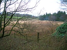
maps show the site as an area free of trees and later (1911–12) as the site of a curling pond. In 2011 the drainage here remains inadequate and the area is dominated by marsh plants.
46:
276:
287:
The OS map of 1911-12 shows that a curling pond was excavated on part of the old loch site. This pond was abandoned by 1958 as it is no longer shown.
241:
Hessilhead Castle has been demolished. Extensive quarrying around the site has removed any possible traces of a moat. No building vestiges remain.
94:
312:
218:, Scotland. The old loch, used in the defence of the castle, was probably infilled when the castle ruins were landscaped in the 19th century.
615:
333:
483:
551:
529:
518:
178:
620:
610:
452:
380:
524:
Love, Dane (2005). Lost
Ayrshire : Ayrshire's Lost Architectural Heritage. Edinburgh : Birlinn Ltd.
467:
605:
151:
252:
537:
The
Castellated and Domestic Architecture of Scotland from the Twelfth to the Eighteenth Centuries
501:
Cunninghame, Topographized by
Timothy Pont 1604–1608, with continuations and illustrative notices
139:
547:
525:
514:
589:
471:
303:
30:
215:
163:
79:
599:
126:
231:
296:
244:
579:
572:
567:
207:
75:
428:
109:
96:
140:
152:
259:
in which it was stated that the castle stood in the middle of a loch
275:
The loch's drainage may have begun in the early 18th century when
230:
211:
191:
264:
132:
464:
243:
The drainage from the quarry does use what was once a moat
440:
206:
was situated in a low-lying area near the old Castle of
337:
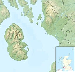
Previous location of
Hessilhead Loch, North Ayrshire
35:
The site of
Hessilhead Loch from the old castle site
574:
Commentary and video on
Hessilhead Castle and loch.
187:
177:
173:
162:
150:
138:
125:
86:
71:
23:
18:
Drained freshwater loch in North
Ayrshire, Scotland
87:
8:
277:Alexander Montgomerie, 10th Earl of Eglinton
239:In 1956 the Royal Commission recorded that
20:
499:Dobie, James D. (ed Dobie, J.S.) (1876).
535:MacGibbon and Ross, D and T (1887–92).
352:
319:
53:
506:Kilmarnock Standard, August 13, 1949.
235:The castle ruins in the 19th century.
7:
511:Ayrshire : Discovering a County
358:
356:
14:
295:Blaeu's map of 1654, dating from
582:
318:
311:
52:
45:
29:
546:. Glasgow : Neil Wilson.
513:. Ayr : Fort Publishing.
1:
70:
616:Freshwater lochs of Scotland
569:YouTube Commentary and video
503:. Glasgow : John Tweed.
419:MacIntosh, Pages 37 & 39
539:, 5 V, Edinburgh, Vol. III.
486:Retrieved : 2011-02-17
474:Retrieved : 2011-02-17
455:Retrieved : 2011-02-17
443:Retrieved : 2011-02-17
431:Retrieved : 2011-02-17
383:Retrieved : 2011-02-17
637:
542:MacIntosh, Donald (2006).
255:in 1949 wrote an article
40:
28:
257:Ancient Ayrshire Castles
621:Lakes of North Ayrshire
611:Lochs of North Ayrshire
381:The RCAHMS Canmoresite.
263:, presumably meaning a
236:
110:55.746806°N 4.581583°W
291:Cartographic evidence
234:
392:Love (2005), Page 14
334:class=notpageimage|
115:55.746806; -4.581583
544:Travels in Galloway
509:Love, Dane (2003).
362:Kilmarnock Standard
253:Kilmarnock Standard
146:Rainfall and runoff
131:Drained freshwater
106: /
470:2011-04-11 at the
410:McGibbon, Page 376
237:
302:The 19th century
210:in the Parish of
197:
196:
628:
592:
587:
586:
585:
487:
481:
475:
462:
456:
450:
444:
438:
432:
426:
420:
417:
411:
408:
402:
401:Dobie, Page 194.
399:
393:
390:
384:
378:
372:
369:
363:
360:
322:
321:
315:
154:
153:Primary outflows
142:
121:
120:
118:
117:
116:
111:
107:
104:
103:
102:
99:
89:
56:
55:
49:
33:
21:
636:
635:
631:
630:
629:
627:
626:
625:
596:
595:
590:Scotland portal
588:
583:
581:
562:
557:
490:
482:
478:
472:Wayback Machine
463:
459:
451:
447:
439:
435:
427:
423:
418:
414:
409:
405:
400:
396:
391:
387:
379:
375:
370:
366:
361:
354:
345:
340:
339:
338:
336:
330:
329:
328:
327:
326:Hessilhead Loch
323:
304:Ordnance Survey
293:
285:
273:
229:
224:
200:Hessilhead Loch
166: countries
141:Primary inflows
114:
112:
108:
105:
100:
97:
95:
93:
92:
67:
66:
65:
64:
63:
62:
61:
60:Hessilhead Loch
57:
36:
24:Hessilhead Loch
19:
12:
11:
5:
634:
632:
624:
623:
618:
613:
608:
598:
597:
594:
593:
578:
577:
576:
575:
570:
561:
560:External links
558:
556:
555:
540:
533:
522:
507:
504:
496:
495:
494:
489:
488:
476:
457:
445:
433:
421:
412:
403:
394:
385:
373:
364:
351:
350:
349:
344:
341:
332:
331:
325:
324:
317:
316:
310:
309:
308:
292:
289:
284:
281:
272:
269:
228:
225:
223:
220:
216:North Ayrshire
204:Hazelhead Loch
195:
194:
189:
185:
184:
181:
175:
174:
171:
170:
167:
160:
159:
156:
148:
147:
144:
136:
135:
129:
123:
122:
90:
84:
83:
80:North Ayrshire
73:
69:
68:
59:
58:
51:
50:
44:
43:
42:
41:
38:
37:
34:
26:
25:
17:
13:
10:
9:
6:
4:
3:
2:
633:
622:
619:
617:
614:
612:
609:
607:
604:
603:
601:
591:
580:
573:
571:
568:
566:
565:
564:
563:
559:
553:
552:1-897784-92-9
549:
545:
541:
538:
534:
531:
530:1-84158-356-1
527:
523:
520:
519:0-9544461-1-9
516:
512:
508:
505:
502:
498:
497:
492:
491:
485:
480:
477:
473:
469:
466:
461:
458:
454:
453:Thomson's Map
449:
446:
442:
437:
434:
430:
425:
422:
416:
413:
407:
404:
398:
395:
389:
386:
382:
377:
374:
371:Love, Page 89
368:
365:
359:
357:
353:
347:
346:
342:
335:
314:
307:
305:
300:
298:
290:
288:
282:
280:
278:
270:
268:
266:
262:
258:
254:
249:
246:
242:
233:
227:Defensive use
226:
221:
219:
217:
213:
209:
205:
201:
193:
190:
186:
182:
180:
176:
172:
168:
165:
161:
157:
155:
149:
145:
143:
137:
134:
130:
128:
124:
119:
91:
85:
81:
77:
74:
48:
39:
32:
27:
22:
16:
606:Former lochs
543:
536:
510:
500:
479:
460:
448:
436:
424:
415:
406:
397:
388:
376:
367:
301:
297:Timothy Pont
294:
286:
283:Curling Pond
274:
261:with ditches
260:
256:
250:
245:Timothy Pont
240:
238:
203:
199:
198:
98:55°44′48.5″N
15:
484:Google Maps
429:Blaeu's Map
188:Settlements
113: /
101:4°34′53.7″W
88:Coordinates
600:Categories
343:References
208:Hessilhead
158:Dusk Water
82:, Scotland
76:Hessilhead
441:Roy's Map
468:Archived
465:NLS Maps
271:Drainage
169:Scotland
72:Location
493:Sources
222:History
179:Islands
550:
528:
517:
348:Notes
212:Beith
192:Beith
164:Basin
548:ISBN
526:ISBN
515:ISBN
265:moat
251:The
183:None
133:loch
127:Type
202:or
602::
355:^
267:.
214:,
78:,
554:.
532:.
521:.
Text is available under the Creative Commons Attribution-ShareAlike License. Additional terms may apply.