36:
66:
285:, featuring over 200 camping and picnic sites, and two improved boat ramps. The lake is a destination for salmon and trout fishing, as well as for small boat sailing. Boat speeds are restricted by a 'no-wake' policy. A 5.5-mile (8.9 km) hiking trail crosses the Rio Chama Gorge via a pedestrian suspension bridge, and then runs southwest through wooded terrain to the grounds of
73:
43:
274:
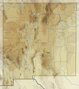
266:, which was completed in 1971. The 5,900-acre (24 km) lake is approximately 4 miles (6 km) long and 3 miles (5 km) wide, and lies at an elevation of up to 7,186 feet (2,190 m). Heron Dam is owned and operated by the
1148:
292:
The lake, dam, and state park are named for
Kenneth A. Heron, an engineer in the early 1900s who first explored the concept of diverting water from Colorado to the desert regions of southern New Mexico.
703:
213:
390:
726:
754:
1185:
1180:
383:
35:
650:
447:
721:
510:
240:
1054:
112:
782:
731:
65:
579:
925:
736:
500:
442:
376:
698:
680:
645:
399:
1099:
670:
267:
212:
1175:
675:
660:
1170:
480:
462:
1064:
953:
665:
619:
655:
571:
556:
840:
1084:
1029:
528:
452:
419:
835:
551:
470:
228:
98:
1059:
820:
815:
532:
505:
495:
485:
974:
865:
825:
713:
475:
236:
1119:
1109:
1019:
994:
989:
895:
890:
805:
690:
490:
969:
910:
746:
424:
1044:
999:
979:
637:
627:
609:
594:
520:
434:
1114:
1089:
1049:
1014:
1004:
984:
905:
900:
845:
790:
604:
1124:
1069:
1034:
943:
589:
584:
543:
1134:
1094:
915:
885:
860:
810:
795:
411:
1104:
800:
599:
256:
1129:
880:
338:
830:
262:
Water is impounded in Heron Lake by the 1,250-foot (380 m) long, 263-foot (80 m) high
764:
1079:
875:
870:
363:
855:
850:
772:
561:
277:
The Brazos Cliffs, Heron Lake, and the north wall of the Rio Chama Gorge, looking east.
156:
1164:
144:
313:
1024:
1009:
286:
1074:
938:
933:
368:
403:
252:
232:
127:
114:
948:
263:
248:
224:
149:
244:
273:
272:
235:
in the southwestern United States. The reservoir is part of the
1149:
New Mexico
Department of Energy, Minerals, and Natural Resources
372:
341:. New Mexico Energy, Minerals and Natural Resources Department
211:
962:
924:
781:
763:
745:
712:
689:
636:
618:
570:
542:
519:
461:
433:
410:
202:
194:
186:
178:
170:
166:
155:
143:
104:
94:
23:
755:List of National Natural Landmarks in New Mexico
105:
255:watershed. Lake Heron is 80 miles northwest of
384:
8:
308:
306:
391:
377:
369:
20:
18:Reservoir in Rio Arriba County, New Mexico
216:Location of Heron Lake within New Mexico
302:
1186:Lakes of Rio Arriba County, New Mexico
1181:Parks in Rio Arriba County, New Mexico
281:The southern shore is the location of
198:401,000 acre-feet (495,000,000 m)
7:
268:United States Bureau of Reclamation
72:
42:
14:
71:
64:
41:
34:
201:
193:
185:
177:
169:
1:
1055:Living Desert Zoo and Gardens
704:Fort Stanton–Snowy River Cave
552:Camino Real de Tierra Adentro
99:Rio Arriba County, New Mexico
93:
85:Show map of the United States
727:Organ Mountains–Desert Peaks
691:National Conservation Areas
1202:
747:National Natural Landmarks
1176:State parks of New Mexico
1143:
638:National Wildlife Refuges
521:National Recreation Areas
435:National Historical Parks
28:
1171:Reservoirs in New Mexico
1100:Rio Grande Nature Center
190:5,900 acres (24 km)
722:Kasha-Katuwe Tent Rocks
511:Salinas Pueblo Missions
339:"Heron Lake State Park"
314:"Heron Lake State Park"
251:, which is part of the
926:Wild and Scenic Rivers
714:BLM National Monuments
278:
237:San Juan–Chama Project
217:
55:Show map of New Mexico
1065:Mesilla Valley Bosque
934:East Fork Jemez River
732:Prehistoric Trackways
364:Heron Lake State Park
283:Heron Lake State Park
276:
239:, which connects the
215:
182:3 mi (5 km)
174:4 mi (6 km)
737:Rio Grande del Norte
501:Gila Cliff Dwellings
206:7,186 feet (2,190 m)
1085:Oliver Lee Memorial
1030:Elephant Butte Lake
620:National Grasslands
124: /
836:Chama River Canyon
765:National Preserves
463:National monuments
279:
218:
1158:
1157:
1060:Manzano Mountains
821:Capitan Mountains
816:Bosque del Apache
651:Bosque del Apache
580:Apache–Sitgreaves
557:Old Spanish Trail
448:Manhattan Project
229:Rio Arriba County
210:
209:
203:Surface elevation
1193:
975:Bottomless Lakes
866:Manzano Mountain
826:Carlsbad Caverns
572:National Forests
420:Carlsbad Caverns
393:
386:
379:
370:
351:
350:
348:
346:
335:
329:
328:
326:
324:
310:
139:
138:
136:
135:
134:
129:
128:36.69°N 106.69°W
125:
122:
121:
120:
117:
107:
86:
75:
74:
68:
56:
45:
44:
38:
21:
1201:
1200:
1196:
1195:
1194:
1192:
1191:
1190:
1161:
1160:
1159:
1154:
1139:
1120:Sugarite Canyon
1110:Santa Rosa Lake
1020:Eagle Nest Lake
995:Cimarron Canyon
990:Cerrillos Hills
958:
920:
896:Sandia Mountain
891:San Pedro Parks
841:Columbine–Hondo
806:Bisti/De-Na-Zin
777:
759:
741:
708:
685:
632:
614:
566:
544:National Trails
538:
515:
481:Capulin Volcano
457:
429:
406:
400:Protected areas
397:
360:
355:
354:
344:
342:
337:
336:
332:
322:
320:
312:
311:
304:
299:
159: countries
132:
130:
126:
123:
118:
115:
113:
111:
110:
90:
89:
88:
87:
84:
83:
82:
81:
80:
76:
59:
58:
57:
54:
53:
52:
51:
50:
46:
19:
12:
11:
5:
1199:
1197:
1189:
1188:
1183:
1178:
1173:
1163:
1162:
1156:
1155:
1153:
1152:
1144:
1141:
1140:
1138:
1137:
1132:
1127:
1122:
1117:
1112:
1107:
1102:
1097:
1092:
1087:
1082:
1077:
1072:
1067:
1062:
1057:
1052:
1047:
1042:
1037:
1032:
1027:
1022:
1017:
1012:
1007:
1002:
997:
992:
987:
982:
977:
972:
970:Bluewater Lake
966:
964:
960:
959:
957:
956:
951:
946:
941:
936:
930:
928:
922:
921:
919:
918:
913:
911:White Mountain
908:
903:
898:
893:
888:
883:
878:
873:
868:
863:
858:
853:
848:
843:
838:
833:
828:
823:
818:
813:
808:
803:
798:
793:
787:
785:
779:
778:
776:
775:
773:Valles Caldera
769:
767:
761:
760:
758:
757:
751:
749:
743:
742:
740:
739:
734:
729:
724:
718:
716:
710:
709:
707:
706:
701:
695:
693:
687:
686:
684:
683:
678:
673:
668:
663:
658:
653:
648:
642:
640:
634:
633:
631:
630:
624:
622:
616:
615:
613:
612:
607:
602:
597:
592:
587:
582:
576:
574:
568:
567:
565:
564:
562:Santa Fe Trail
559:
554:
548:
546:
540:
539:
537:
536:
525:
523:
517:
516:
514:
513:
508:
503:
498:
493:
488:
483:
478:
473:
467:
465:
459:
458:
456:
455:
450:
445:
439:
437:
431:
430:
428:
427:
422:
416:
414:
412:National Parks
408:
407:
398:
396:
395:
388:
381:
373:
367:
366:
359:
358:External links
356:
353:
352:
330:
318:Recreation.gov
301:
300:
298:
295:
241:San Juan River
208:
207:
204:
200:
199:
196:
192:
191:
188:
184:
183:
180:
176:
175:
172:
168:
167:
164:
163:
160:
153:
152:
147:
141:
140:
133:36.69; -106.69
108:
102:
101:
96:
92:
91:
78:
77:
70:
69:
63:
62:
61:
60:
48:
47:
40:
39:
33:
32:
31:
30:
29:
26:
25:
17:
13:
10:
9:
6:
4:
3:
2:
1198:
1187:
1184:
1182:
1179:
1177:
1174:
1172:
1169:
1168:
1166:
1151:
1150:
1146:
1145:
1142:
1136:
1133:
1131:
1128:
1126:
1123:
1121:
1118:
1116:
1113:
1111:
1108:
1106:
1103:
1101:
1098:
1096:
1093:
1091:
1088:
1086:
1083:
1081:
1078:
1076:
1073:
1071:
1068:
1066:
1063:
1061:
1058:
1056:
1053:
1051:
1048:
1046:
1045:Hyde Memorial
1043:
1041:
1038:
1036:
1033:
1031:
1028:
1026:
1023:
1021:
1018:
1016:
1013:
1011:
1008:
1006:
1003:
1001:
1000:City of Rocks
998:
996:
993:
991:
988:
986:
983:
981:
980:Brantley Lake
978:
976:
973:
971:
968:
967:
965:
961:
955:
952:
950:
947:
945:
942:
940:
937:
935:
932:
931:
929:
927:
923:
917:
914:
912:
909:
907:
904:
902:
899:
897:
894:
892:
889:
887:
884:
882:
879:
877:
874:
872:
869:
867:
864:
862:
859:
857:
854:
852:
849:
847:
844:
842:
839:
837:
834:
832:
829:
827:
824:
822:
819:
817:
814:
812:
809:
807:
804:
802:
799:
797:
794:
792:
789:
788:
786:
784:
780:
774:
771:
770:
768:
766:
762:
756:
753:
752:
750:
748:
744:
738:
735:
733:
730:
728:
725:
723:
720:
719:
717:
715:
711:
705:
702:
700:
697:
696:
694:
692:
688:
682:
679:
677:
674:
672:
669:
667:
664:
662:
659:
657:
654:
652:
649:
647:
644:
643:
641:
639:
635:
629:
626:
625:
623:
621:
617:
611:
608:
606:
603:
601:
598:
596:
593:
591:
588:
586:
583:
581:
578:
577:
575:
573:
569:
563:
560:
558:
555:
553:
550:
549:
547:
545:
541:
534:
530:
527:
526:
524:
522:
518:
512:
509:
507:
504:
502:
499:
497:
494:
492:
489:
487:
484:
482:
479:
477:
474:
472:
469:
468:
466:
464:
460:
454:
451:
449:
446:
444:
443:Chaco Culture
441:
440:
438:
436:
432:
426:
423:
421:
418:
417:
415:
413:
409:
405:
401:
394:
389:
387:
382:
380:
375:
374:
371:
365:
362:
361:
357:
340:
334:
331:
319:
315:
309:
307:
303:
296:
294:
290:
288:
284:
275:
271:
269:
265:
260:
258:
254:
250:
246:
242:
238:
234:
230:
226:
222:
214:
205:
197:
189:
181:
173:
165:
162:United States
161:
158:
154:
151:
148:
146:
142:
137:
109:
103:
100:
97:
67:
37:
27:
22:
16:
1147:
1115:Storrie Lake
1090:Pancho Villa
1050:Leasburg Dam
1039:
1025:El Vado Lake
1015:Coyote Creek
1010:Conchas Lake
1005:Clayton Lake
985:Caballo Lake
906:Wheeler Peak
901:West Malpais
846:Cruces Basin
791:Aldo Leopold
681:Valle de Oro
343:. Retrieved
333:
321:. Retrieved
317:
291:
289:State Park.
287:El Vado Lake
282:
280:
261:
220:
219:
195:Water volume
187:Surface area
15:
1125:Sumner Lake
1075:Navajo Lake
1070:Morphy Lake
1035:Fenton Lake
963:State Parks
939:Pecos River
646:Bitter Lake
471:Aztec Ruins
425:White Sands
171:Max. length
131: /
106:Coordinates
1165:Categories
1135:Villanueva
1095:Percha Dam
1040:Heron Lake
954:Rio Grande
916:Withington
886:Salt Creek
861:Latir Peak
811:Blue Range
796:Apache Kid
783:Wilderness
699:El Malpais
671:San Andres
506:Petroglyph
496:Fort Union
486:El Malpais
404:New Mexico
297:References
253:Rio Grande
233:New Mexico
221:Heron Lake
179:Max. width
79:Heron Lake
49:Heron Lake
24:Heron Lake
1105:Rockhound
949:Rio Chama
944:Red River
801:Bandelier
676:Sevilleta
661:Las Vegas
476:Bandelier
264:Heron Dam
249:Rio Chama
225:reservoir
150:reservoir
1130:Ute Lake
881:Sabinoso
610:Santa Fe
595:Coronado
491:El Morro
257:Santa Fe
245:Colorado
119:106°41′W
95:Location
831:Cebolla
666:Maxwell
605:Lincoln
345:July 2,
323:July 2,
247:to the
116:36°41′N
656:Grulla
590:Cibola
585:Carson
1080:Oasis
876:Pecos
871:Ojito
628:Kiowa
529:Jemez
453:Pecos
223:is a
157:Basin
856:Gila
851:Dome
600:Gila
533:USFS
347:2022
325:2022
145:Type
402:of
243:in
227:in
1167::
316:.
305:^
270:.
259:.
231:,
535:)
531:(
392:e
385:t
378:v
349:.
327:.
Text is available under the Creative Commons Attribution-ShareAlike License. Additional terms may apply.