133:
126:
46:
324:
732:
436:
is the longest, 14 km (8.7 mi), overgrown and unmarked in places, with windfalls, slips and flooding after heavy rain. It starts on
Crawford Road on the north bank of the Waikawau River, near Waikawau, follows the river, then Mangapapa Stream to Waikawau Saddle and then drops to Leitch's
399:
Currently 4 tracks offer alternative routes to Leitch's Hut, which has 16 bunk beds, heating, mattresses, non-flush toilets, untreated tap water and no booking system. Sam Leitch was awarded the area in a World War I soldiers' land ballot. His home was in the clearing where the hut is and his
429:
crosses the
Herangi Range for 8 km (5.0 mi), starting at the Mangatoa Road saddle and gradually climbing to the Herangi Ridge, before turning right, down to the Waikawau Track junction and Leitch's Hut. It too is not passable after heavy rain.
408:
remain. The tracks are classed as
Advanced Tramping tracks, in the more difficult 5th level, as defined in DoC's 6 levels of walking track categories. The exception is Leitch's Track, which is a level easier, as an Intermediate: Easier tramping track.
449:. It has a moist climate, with rainfall of 1.6 to 2.50m a year. The ridges are covered by a sub-alpine vegetation of low scrub and kaikawaka along with neinei, pepperwood and divaricating shrubs interspersed with areas of cushion bog. At lower levels
226:
II crashed into a tree on a ridge between
Whareorino (649 m (2,129 ft)) and Mangatoa Saddle on 21 July 2009. The pilot, who died, was inexperienced and had not complied with requirements to calculate a route allowing for the poor weather.
235:
The main peaks from north to south are
Maungamangero 806 m (2,644 ft), Te Heruera 756 m (2,480 ft), Maugatewharau 795 m (2,608 ft), Te Whakapatiki 766 m (2,513 ft) and Herangi 725 m (2,379 ft).
422:
follows the
Awakino River for 12 km (7.5 mi). It is closed from 1 September to 10 October each year for lambing. It starts at the end of Gribbon Road and crosses the river near the hut, but is not passable after heavy rain.
969:
239:
Mangatoa and
Manganui Roads follow a north–south route through the ranges, running from Marokopa, 56 km (35 mi) south, via Kiritehere, Moeatoa, rising over the 311 m (1,020 ft) Mangatoa Saddle,
415:
is over 8.5 km (5.3 mi). It starts at the end of Leitch Road, on a well graded road, then passes farmland and climbs into bush, before descending to Leitch's clearing, with no major streams to cross.
280:
foundered on the reef in fog on 13 June 1907, with the loss of 3 lives. The Chief
Officer was blamed, with a suspicion of being inebriated, but his suspended certificate was returned within a few months.
259:
Mt Duthie, 372 m (1,220 ft), gets about 2 m (6 ft 7 in) of rain a year. It and 332 m (1,089 ft) Mt
Brookes were named after the surveyors who mapped them, F Duthie and
289:
Tirua Point has cliffs on the north side of the Point rising to over 100 m (330 ft). In the 1860s it was thought the country was at its 198 mi (319 km) widest between
1633:
272:
Piritoki Reef lies about 1 km (0.62 mi) north of Tirua Point. Its sharp rocks create an area of turbulent sea. They rise to about a metre above sea level. The
1619:
1430:
1406:
1382:
1334:
1501:
1205:
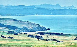
546:
482:
628:
550:
1188:
1570:
125:
1300:
604:
1668:
490:
82:
481:
is found in moist, medium to high-altitude forest. Herangi and
Coromandel Ranges are the only places where natural remnants of these
215:
and other archaeological sites are found close together along the coast, but very few in the range itself. The Kiritehere valley was
182:
1358:
219:
in the 1900s, but much of the rest of the range is in Whareorino Conservation Area, of particular importance for its native frogs.
328:
446:
198:
1224:"Mesozoic stratigraphy of the Marokopa area, southwest Auckland, New Zealand, New Zealand Journal of Geology and Geophysics"
715:
301:
of the northern headland of Ngararahae Bay, just south of Tirua Point as 1742785, and Marau Point, on the north side of
75:
1480:
1458:
364:
298:
391:
often underlain by more resistant sandstone. The coast has near-vertical cliffs, generally behind an ironsand beach.
882:
856:
294:
273:
1673:
261:
1116:
194:
494:
190:
945:
305:, on same latitude on the east coast, as 2068929 the difference being just over 326 km (203 mi).
1595:
1117:"ENZB - 1867 - Stevens and Bartholomew's New Zealand directory for 1866-67 - AUCKLAND PROVINCE, p 277-286"
514:
522:
302:
26:
474:
181:
at Tapirimoko, Tirua, Taungaururoa, Te Mauku and Ngarupupu Points. Just to the south of Ngarupupu, the
673:
993:
530:
518:
510:
506:
502:
256:
vessel, Parera, off the beach at Nukuhakari. Prior to that, even travel on horseback was difficult.
498:
831:
756:
45:
920:
806:
553:
in the 1920s. DoC and Regional Council have a programme to control goats and possums in Herangi.
526:
462:
454:
1067:
1042:
781:
248:
to follow the Manganui valley through to Awakino. The road was built about 1935, when the last
205:
1017:
690:
1613:
1281:
1140:
458:
384:
317:
245:
1308:
896:
575:
1271:
1235:
478:
380:
368:
323:
186:
30:
1092:
1164:
534:
486:
361:
1653:
466:
309:
1662:
1546:
1522:
1276:
1259:
1240:
1223:
253:
149:
401:
290:
223:
178:
1285:
1260:"Mesozoic stratigraphy of the Marokopa area, southwest Auckland, New Zealand"
649:
97:
84:
405:
388:
357:
353:
349:
470:
450:
376:
372:
345:
341:
249:
241:
166:
1068:"Packet Licenses and-the Kia Ora. KAWHIA SETTLER AND RAGLAN ADVERTISER"
216:
174:
170:
145:
22:
465:, many forest birds and, in 1987, there were occasional sightings of
65:
51:
493:'s 645 ha (1,590 acres) Steuart Russell Reserve has a sizeable
485:
frogs live. Some tracks have been closed to prevent the spread of
322:
212:
313:
208:
1594:
L. T. Pracy, A. L. Poole, Director-General of Forests (1962).
320:, planted in 2015, 2016 and 2017, have reduced sand movement.
1634:"Waikato Regional Pest Management Plan Annual report 2016/17"
331:
sandstone cliffs of Maungamangero in the mid distance centre
832:"ON HORSEBACK THROUGH THE KING COUNTRY. NEW ZEALAND HERALD"
994:"Northern Steam Ship Company of Auckland - Vessel details"
327:
Marokopa in the foreground, Kiritehere valley beyond and
1301:"Geology of the Waikato area 1:250 000 geological map 4"
716:"AIRCRAFT ACCIDENT REPORT CAA OCCURRENCE NUMBER 09/2776"
545:
Marokopa was one of many areas around the country where
1043:"The s.s. Kia Ora KAWHIA SETTLER AND RAGLAN ADVERTISER"
674:"Waitomo District Plan Section 21: Heritage Resources"
348:
Newcastle Group form the west side of the range, with
316:
in both Nukuhakari and Ngararahae Bays. Thousands of
1502:"Waikato Conservation Management Strategy 2014–2024"
340:
Herangi is part of the roughly north - south Kāwhia
185:
enters the sea. Other rivers draining the range are
437:Clearing and crosses the Awakino River to the hut.
113:
74:
64:
59:
38:
497:population and is the most northerly forest where
1481:"Ecological regions and districts of New Zealand"
1459:"Ecological regions and districts of New Zealand"
453:is abundant on lower slopes facing the sea, but
50:The north end of the Herangi Range viewed from
1305:Institute of Geological & Nuclear Sciences
1264:New Zealand Journal of Geology and Geophysics
1228:New Zealand Journal of Geology and Geophysics
691:"FRONTIER SETTLEMENT. KING COUNTRY CHRONICLE"
16:Range of hills in Waikato Region, New Zealand
8:
1618:: CS1 maint: multiple names: authors list (
1596:"INTRODUCTION AND LIBERATION OF THE OPOSSUM"
782:"LAST WOOL SHIPMENT. KING COUNTRY CHRONICLE"
25:. Not to be confused with Herangi Hill near
883:"THE PIONEER LAND SURVEYORS OF NEW ZEALAND"
537:, were recorded on Maungamangero in 1983.
35:
21:This article is about a mountain range in
1275:
1239:
921:"STORY OF THE WRECK. BAY OF PLENTY TIMES"
371:rocks. The main rivers flow across broad
312:, where grazing increased the advance of
445:The Herangi Range is part of Whareorino
562:
177:region of New Zealand, reaching to the
1611:
1575:New Zealand Plant Conservation Network
461:scrub at higher levels. Birds include
1571:"Herangi Ra, Mt Maungamangero (HERA)"
1452:
1450:
1329:
1327:
1325:
1253:
1251:
375:floodplains, from which the hills of
244:and a lower 230 m (750 ft)
132:
54:; Taranaki Point in the near distance
7:
1189:"Beachcare Magazine Edition 5, 2014"
629:"2 Matters of Significance to Maori"
599:
597:
595:
570:
568:
566:
197:. Herangi is part of the Whareorino
807:"SHIPPING NEWS. NEW ZEALAND TIMES"
457:is dominant inland, giving way to
14:
974:fishing-app.gpsnauticalcharts.com
857:"Mt Duthie manager single minded"
367:carbonaceous sandstone and other
1018:"KIA ORA INQUIRY. AUCKLAND STAR"
491:Native Forests Restoration Trust
131:
124:
44:
1551:NATIVE FOREST RESTORATION TRUST
360:folded, faulted and covered by
605:"Whareorino Conservation Area"
477:lives by most of the streams.
1:
1277:10.1080/00288306.1998.9514812
1241:10.1080/00288306.1998.9514812
308:Tirua Point is on Nukuhakari
165:is a range of hills south of
1523:"King Country Hiking Trails"
1479:W. Mary McEwen (June 1987).
1457:W. Mary McEwen (June 1987).
1258:MacFarlan, D. A. B. (1998).
274:Northern Steamship Company's
1222:D. A. B. MacFarlan (1998).
1690:
1669:Mountain ranges of Waikato
1488:Department of Conservation
1466:Department of Conservation
1359:"Walking track categories"
998:www.nzmaritimeindex.org.nz
70:806 m (2,644 ft)
20:
1141:"Ngararahae Bay, Waikato"
1072:paperspast.natlib.govt.nz
1047:paperspast.natlib.govt.nz
1022:paperspast.natlib.govt.nz
925:paperspast.natlib.govt.nz
836:paperspast.natlib.govt.nz
811:paperspast.natlib.govt.nz
786:paperspast.natlib.govt.nz
761:paperspast.natlib.govt.nz
695:paperspast.natlib.govt.nz
547:acclimatisation societies
379:rock rise sharply. Steep
262:Edwin Stanley Brookes Jnr
118:
43:
1654:Photo of Moeatoa in 2014
1600:scion.contentdm.oclc.org
1299:Edbrooke, S. W. (2005).
946:"-38.375605, 174.633590"
897:"Piritoki Reef, Waikato"
763:. 2 Jan 1935. p. 11
636:Waikato Regional Council
576:"HERANGI RANGE, Waikato"
1165:"Marau Point, Gisborne"
1121:www.enzb.auckland.ac.nz
654:archsite.eaglegis.co.nz
495:North Island brown kiwi
489:to Archey's frogs. The
1093:"Tirua Point, Waikato"
332:
1527:www.kingcountry.co.nz
733:"Awakino to Marokopa"
483:critically endangered
326:
293:and Tirua Point. The
27:Cape Maria van Diemen
757:"WANGANUI CHRONICLE"
531:Caladenia bartlettii
503:Brachyglottis kirkii
501:dominates. Uncommon
387:are prominent, with
94: /
650:"NZAA Site Viewer"
475:Hochstetter's frog
333:
252:plied wool to the
204:Herangi is in the
60:Highest point
1547:"Steuart Russell"
1211:. September 2018.
1206:"West Coast News"
535:Corybas rivularis
529:and the orchids,
447:Conservation Area
381:homoclinal ridges
224:Reims Cessna F152
199:conservation area
160:
159:
1681:
1674:Waitomo District
1641:
1640:
1638:
1630:
1624:
1623:
1617:
1609:
1607:
1606:
1591:
1585:
1584:
1582:
1581:
1567:
1561:
1560:
1558:
1557:
1543:
1537:
1536:
1534:
1533:
1519:
1513:
1512:
1506:
1498:
1492:
1491:
1485:
1476:
1470:
1469:
1463:
1454:
1445:
1444:
1442:
1441:
1431:"Waikawau Track"
1427:
1421:
1420:
1418:
1417:
1407:"Mangatoa Track"
1403:
1397:
1396:
1394:
1393:
1383:"Mahoenui Track"
1379:
1373:
1372:
1370:
1369:
1355:
1349:
1348:
1346:
1345:
1335:"Leitch's Track"
1331:
1320:
1319:
1317:
1316:
1307:. Archived from
1296:
1290:
1289:
1279:
1255:
1246:
1245:
1243:
1219:
1213:
1212:
1210:
1202:
1196:
1195:
1193:
1185:
1179:
1178:
1176:
1175:
1161:
1155:
1154:
1152:
1151:
1137:
1131:
1130:
1128:
1127:
1113:
1107:
1106:
1104:
1103:
1089:
1083:
1082:
1080:
1079:
1064:
1058:
1057:
1055:
1054:
1039:
1033:
1032:
1030:
1029:
1014:
1008:
1007:
1005:
1004:
990:
984:
983:
981:
980:
966:
960:
959:
957:
956:
942:
936:
935:
933:
932:
917:
911:
910:
908:
907:
893:
887:
886:
878:
872:
871:
869:
868:
853:
847:
846:
844:
843:
828:
822:
821:
819:
818:
803:
797:
796:
794:
793:
778:
772:
771:
769:
768:
753:
747:
746:
744:
743:
729:
723:
722:
720:
712:
706:
705:
703:
702:
687:
681:
680:
678:
670:
664:
663:
661:
660:
646:
640:
639:
633:
625:
619:
618:
616:
615:
601:
590:
589:
587:
586:
572:
187:Mangaotaki River
135:
134:
128:
109:
108:
106:
105:
104:
99:
95:
92:
91:
90:
87:
48:
36:
1689:
1688:
1684:
1683:
1682:
1680:
1679:
1678:
1659:
1658:
1650:
1645:
1644:
1636:
1632:
1631:
1627:
1610:
1604:
1602:
1593:
1592:
1588:
1579:
1577:
1569:
1568:
1564:
1555:
1553:
1545:
1544:
1540:
1531:
1529:
1521:
1520:
1516:
1504:
1500:
1499:
1495:
1483:
1478:
1477:
1473:
1461:
1456:
1455:
1448:
1439:
1437:
1435:www.doc.govt.nz
1429:
1428:
1424:
1415:
1413:
1411:www.doc.govt.nz
1405:
1404:
1400:
1391:
1389:
1387:www.doc.govt.nz
1381:
1380:
1376:
1367:
1365:
1363:www.doc.govt.nz
1357:
1356:
1352:
1343:
1341:
1339:www.doc.govt.nz
1333:
1332:
1323:
1314:
1312:
1298:
1297:
1293:
1257:
1256:
1249:
1221:
1220:
1216:
1208:
1204:
1203:
1199:
1191:
1187:
1186:
1182:
1173:
1171:
1163:
1162:
1158:
1149:
1147:
1139:
1138:
1134:
1125:
1123:
1115:
1114:
1110:
1101:
1099:
1091:
1090:
1086:
1077:
1075:
1066:
1065:
1061:
1052:
1050:
1041:
1040:
1036:
1027:
1025:
1016:
1015:
1011:
1002:
1000:
992:
991:
987:
978:
976:
970:"Piritoki Reef"
968:
967:
963:
954:
952:
944:
943:
939:
930:
928:
919:
918:
914:
905:
903:
895:
894:
890:
880:
879:
875:
866:
864:
855:
854:
850:
841:
839:
830:
829:
825:
816:
814:
805:
804:
800:
791:
789:
780:
779:
775:
766:
764:
755:
754:
750:
741:
739:
731:
730:
726:
721:. 2 March 2012.
718:
714:
713:
709:
700:
698:
689:
688:
684:
676:
672:
671:
667:
658:
656:
648:
647:
643:
631:
627:
626:
622:
613:
611:
609:www.doc.govt.nz
603:
602:
593:
584:
582:
574:
573:
564:
559:
543:
443:
397:
362:Middle Jurassic
338:
287:
270:
233:
156:
155:
154:
153:
152:
143:
142:
141:
140:
136:
102:
100:
98:38.5°S 174.76°E
96:
93:
88:
85:
83:
81:
80:
55:
34:
17:
12:
11:
5:
1687:
1685:
1677:
1676:
1671:
1661:
1660:
1657:
1656:
1649:
1648:External links
1646:
1643:
1642:
1625:
1586:
1562:
1538:
1514:
1493:
1471:
1446:
1422:
1398:
1374:
1350:
1321:
1291:
1270:(3): 297–310.
1247:
1234:(3): 297–310.
1214:
1197:
1180:
1156:
1132:
1108:
1084:
1059:
1034:
1009:
985:
961:
937:
912:
888:
873:
848:
823:
798:
773:
748:
724:
707:
682:
665:
641:
620:
591:
561:
560:
558:
555:
542:
539:
487:chytrid fungus
442:
439:
434:Waikawau Track
427:Mangatoa Track
420:Mahoenui Track
413:Leitch's Track
396:
393:
337:
334:
286:
283:
269:
266:
232:
229:
195:Manganui River
183:Waikawau River
158:
157:
144:
138:
137:
130:
129:
123:
122:
121:
120:
119:
116:
115:
111:
110:
78:
72:
71:
68:
62:
61:
57:
56:
49:
41:
40:
15:
13:
10:
9:
6:
4:
3:
2:
1686:
1675:
1672:
1670:
1667:
1666:
1664:
1655:
1652:
1651:
1647:
1635:
1629:
1626:
1621:
1615:
1601:
1597:
1590:
1587:
1576:
1572:
1566:
1563:
1552:
1548:
1542:
1539:
1528:
1524:
1518:
1515:
1510:
1503:
1497:
1494:
1489:
1482:
1475:
1472:
1467:
1460:
1453:
1451:
1447:
1436:
1432:
1426:
1423:
1412:
1408:
1402:
1399:
1388:
1384:
1378:
1375:
1364:
1360:
1354:
1351:
1340:
1336:
1330:
1328:
1326:
1322:
1311:on 2018-07-21
1310:
1306:
1302:
1295:
1292:
1287:
1283:
1278:
1273:
1269:
1265:
1261:
1254:
1252:
1248:
1242:
1237:
1233:
1229:
1225:
1218:
1215:
1207:
1201:
1198:
1190:
1184:
1181:
1170:
1166:
1160:
1157:
1146:
1142:
1136:
1133:
1122:
1118:
1112:
1109:
1098:
1094:
1088:
1085:
1073:
1069:
1063:
1060:
1049:. 14 Jun 1907
1048:
1044:
1038:
1035:
1024:. 23 Jul 1907
1023:
1019:
1013:
1010:
999:
995:
989:
986:
975:
971:
965:
962:
951:
947:
941:
938:
927:. 19 Jun 1907
926:
922:
916:
913:
902:
898:
892:
889:
884:
877:
874:
862:
858:
852:
849:
838:. 23 Jul 1898
837:
833:
827:
824:
813:. 24 Nov 1924
812:
808:
802:
799:
788:. 14 Mar 1935
787:
783:
777:
774:
762:
758:
752:
749:
738:
734:
728:
725:
717:
711:
708:
697:. 20 Nov 1912
696:
692:
686:
683:
679:. 1 May 2018.
675:
669:
666:
655:
651:
645:
642:
637:
630:
624:
621:
610:
606:
600:
598:
596:
592:
581:
577:
571:
569:
567:
563:
556:
554:
552:
548:
540:
538:
536:
532:
528:
524:
520:
519:northern rātā
516:
512:
511:climbing rātā
508:
504:
500:
496:
492:
488:
484:
480:
479:Archey's frog
476:
472:
468:
464:
460:
456:
452:
448:
440:
438:
435:
431:
428:
424:
421:
417:
414:
410:
407:
403:
400:plantings of
394:
392:
390:
386:
382:
378:
374:
370:
366:
363:
359:
355:
351:
347:
343:
335:
330:
325:
321:
319:
315:
311:
306:
304:
300:
296:
292:
284:
282:
279:
275:
268:Piritoki Reef
267:
265:
263:
257:
255:
254:Holm & Co
251:
247:
243:
237:
230:
228:
225:
220:
218:
214:
210:
207:
202:
200:
196:
192:
191:Awakino River
188:
184:
180:
176:
172:
169:and north of
168:
164:
163:Herangi Range
151:
147:
139:Herangi Range
127:
117:
112:
107:
103:-38.5; 174.76
79:
77:
73:
69:
67:
63:
58:
53:
47:
42:
39:Herangi Range
37:
32:
28:
24:
19:
1628:
1603:. Retrieved
1599:
1589:
1578:. Retrieved
1574:
1565:
1554:. Retrieved
1550:
1541:
1530:. Retrieved
1526:
1517:
1508:
1496:
1487:
1474:
1465:
1438:. Retrieved
1434:
1425:
1414:. Retrieved
1410:
1401:
1390:. Retrieved
1386:
1377:
1366:. Retrieved
1362:
1353:
1342:. Retrieved
1338:
1313:. Retrieved
1309:the original
1304:
1294:
1267:
1263:
1231:
1227:
1217:
1200:
1183:
1172:. Retrieved
1168:
1159:
1148:. Retrieved
1144:
1135:
1124:. Retrieved
1120:
1111:
1100:. Retrieved
1096:
1087:
1076:. Retrieved
1074:. 1 Nov 1907
1071:
1062:
1051:. Retrieved
1046:
1037:
1026:. Retrieved
1021:
1012:
1001:. Retrieved
997:
988:
977:. Retrieved
973:
964:
953:. Retrieved
949:
940:
929:. Retrieved
924:
915:
904:. Retrieved
900:
891:
881:C. A. LAWN.
876:
865:. Retrieved
863:. 2013-05-16
860:
851:
840:. Retrieved
835:
826:
815:. Retrieved
810:
801:
790:. Retrieved
785:
776:
765:. Retrieved
760:
751:
740:. Retrieved
736:
727:
710:
699:. Retrieved
694:
685:
668:
657:. Retrieved
653:
644:
635:
623:
612:. Retrieved
608:
583:. Retrieved
579:
544:
444:
433:
432:
426:
425:
419:
418:
412:
411:
398:
339:
307:
295:1:50,000 map
288:
277:
271:
258:
238:
234:
221:
203:
162:
161:
18:
1169:NZ Topo Map
1145:NZ Topo Map
1097:NZ Topo Map
950:Google Maps
901:NZ Topo Map
737:Google maps
580:NZ Topo Map
549:introduced
527:shrub panax
369:sedimentary
285:Tirua Point
150:New Zealand
101: /
76:Coordinates
1663:Categories
1605:2022-01-12
1580:2022-01-17
1556:2022-01-17
1532:2021-12-05
1440:2021-12-05
1416:2021-12-05
1392:2021-12-05
1368:2022-01-31
1344:2021-12-05
1315:2022-01-31
1174:2022-01-14
1150:2022-01-14
1126:2021-12-04
1102:2021-12-04
1078:2021-12-04
1053:2021-12-04
1028:2021-12-04
1003:2021-12-04
979:2021-12-04
955:2021-12-04
931:2021-12-04
906:2021-12-04
867:2022-01-17
842:2021-12-07
817:2021-12-07
792:2021-12-07
767:2022-01-14
742:2021-12-05
701:2022-01-31
659:2022-01-12
614:2021-12-05
585:2021-12-04
557:References
507:white rātā
499:hard beech
459:tawheowheo
389:dip slopes
365:Rengarenga
354:siltstones
350:sandstones
303:Kaiaua Bay
297:shows the
291:Tolaga Bay
179:Tasman Sea
1286:0028-8306
402:macrocapa
358:greywacke
250:surfboats
231:Geography
206:Maniapoto
173:, in the
114:Geography
66:Elevation
31:Northland
1614:cite web
463:karearea
451:kohekohe
441:Wildlife
406:eleagnus
385:hogbacks
377:Mesozoic
373:alluvial
346:Triassic
342:Syncline
329:Temaikan
318:spinifex
276:307 ton
242:Waikawau
167:Marokopa
89:174°46′E
638:. 2012.
551:possums
336:Geology
310:Station
299:easting
278:Kia Ora
217:settled
175:Waikato
171:Awakino
146:Waikato
86:38°30′S
23:Waikato
1284:
523:rōhutu
515:akatea
471:kōkako
395:Tracks
246:saddle
52:Karioi
1637:(PDF)
1505:(PDF)
1484:(PDF)
1462:(PDF)
1209:(PDF)
1192:(PDF)
861:Stuff
719:(PDF)
677:(PDF)
632:(PDF)
541:Pests
314:dunes
1620:link
1282:ISSN
533:and
469:and
467:kaka
455:tawa
404:and
383:and
356:and
209:rohe
193:and
1509:DoC
1272:doi
1236:doi
1665::
1616:}}
1612:{{
1598:.
1573:.
1549:.
1525:.
1507:.
1486:.
1464:.
1449:^
1433:.
1409:.
1385:.
1361:.
1337:.
1324:^
1303:.
1280:.
1268:41
1266:.
1262:.
1250:^
1232:41
1230:.
1226:.
1167:.
1143:.
1119:.
1095:.
1070:.
1045:.
1020:.
996:.
972:.
948:.
923:.
899:.
859:.
834:.
809:.
784:.
759:.
735:.
693:.
652:.
634:.
607:.
594:^
578:.
565:^
525:,
521:,
517:,
513:,
509:,
505:,
473:.
352:,
344:,
264:.
222:A
213:Pā
211:.
201:.
189:,
148:,
29:,
1639:.
1622:)
1608:.
1583:.
1559:.
1535:.
1511:.
1490:.
1468:.
1443:.
1419:.
1395:.
1371:.
1347:.
1318:.
1288:.
1274::
1244:.
1238::
1194:.
1177:.
1153:.
1129:.
1105:.
1081:.
1056:.
1031:.
1006:.
982:.
958:.
934:.
909:.
885:.
870:.
845:.
820:.
795:.
770:.
745:.
704:.
662:.
617:.
588:.
33:.
Text is available under the Creative Commons Attribution-ShareAlike License. Additional terms may apply.