33:
543:
573:
434:. There were 330 households, comprising 519 males and 444 females, giving a sex ratio of 1.17 males per female. The median age was 43.2 years (compared with 37.4 years nationally), with 222 people (23.1%) aged under 15 years, 141 (14.6%) aged 15 to 29, 432 (44.9%) aged 30 to 64, and 165 (17.1%) aged 65 or older.
329:. There were 30 households, comprising 42 males and 42 females, giving a sex ratio of 1.0 males per female. The median age was 44.5 years (compared with 37.4 years nationally), with 18 people (21.4%) aged under 15 years, 9 (10.7%) aged 15 to 29, 39 (46.4%) aged 30 to 64, and 18 (21.4%) aged 65 or older.
450:
Of those at least 15 years old, 90 (12.1%) people had a bachelor or higher degree, and 183 (24.7%) people had no formal qualifications. The median income was $ 20,600, compared with $ 31,800 nationally. 57 people (7.7%) earned over $ 70,000 compared to 17.2% nationally. The employment status of those
342:
Of those at least 15 years old, 6 (9.1%) people had a bachelor or higher degree, and 18 (27.3%) people had no formal qualifications. The median income was $ 20,300, compared with $ 31,800 nationally. 3 people (4.5%) earned over $ 70,000 compared to 17.2% nationally. The employment status of those at
464:
Herekino was named by the Māori chief Tohe, who passed through on the way to visit the local chief
Taunaha at Owhata and noticed a lasso-type of bird trap which had been incorrectly tied, which would cause the prey unnecessary suffering. He named the area Herekino-a-Taunaha (the false knot of
562:
Herekino School is a coeducational full primary (years 1–8) school with a roll of 31 students as of August 2024. The school was established in 1888. A fire destroyed the first building in 1909, and its replacement also burned down in 1944.
245:
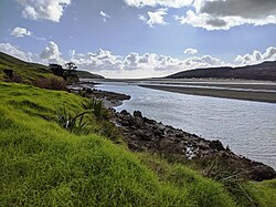
lies on the rocky south shore of the harbour entrance. Owhata is a flat grassy area, with a fairly shallow beach of mud and sand. There is not much natural shelter, and there is a limited supply of fresh water in summer.
501:
was driven ashore on the shallow sand bank just north of the headland. There were no deaths. Wreckage is still visible. Herekino was named on some charts as "False
Hokianga" due to the similarity of the entrances.
511:
In the mid 1960s
Herekino was a small township with shops – a butcher, a petrol station and more. However following the sealing of State Highway 1 through the Mangamuka Gorge to
661:
254:
The SA1 statistical area which includes
Herekino and Owhata covers 11.48 km (4.43 sq mi). The SA1 area is part of the larger Herekino-Takahue statistical area.
2172:
437:
Ethnicities were 64.2% European/Pākehā, 52.3% Māori, 4.0% Pacific peoples, 0.9% Asian, and 1.6% other ethnicities. People may identify with more than one ethnicity.
943:
332:
Ethnicities were 46.4% European/Pākehā, 67.9% Māori, 14.3% Pacific peoples, and 3.6% other ethnicities. People may identify with more than one ethnicity.
2167:
50:
497:, about 30 km to the south, due to misty weather and the similarity of the two features – both have a northern head formed by sand dunes. The
790:
770:
646:
335:
Of those people who chose to answer the census's question about religious affiliation, 28.6% had no religion, 60.7% were
Christian and 7.1% had
730:
627:
1848:
443:
Of those people who chose to answer the census's question about religious affiliation, 39.6% had no religion, 41.7% were
Christian, 3.4% had
1702:
1697:
665:
140:
1601:
597:
936:
237:
The harbour is mostly above water at high tide, with just a shallow entrance channel. The upper reaches of the harbour contain a
1838:
1948:
1050:
903:
451:
at least 15 was that 273 (36.8%) people were employed full-time, 138 (18.6%) were part-time, and 45 (6.1%) were unemployed.
32:
2116:
1898:
845:
2162:
1953:
929:
343:
least 15 was that 21 (31.8%) people were employed full-time, 21 (31.8%) were part-time, and 3 (4.5%) were unemployed.
2100:
2074:
2064:
2023:
2013:
1622:
870:
765:
173:
163:
2048:
1973:
1732:
1722:
1627:
735:
891:
1878:
1737:
1727:
785:
431:
427:
423:
326:
322:
318:
702:
359:. It had an estimated population of 1,110 as of June 2023, with a population density of 3.7 people per km.
1968:
1963:
1873:
1408:
856:
706:
551:
539:: Rangikohu Marae and Ruia te Aroha meeting house; and Manukau Marae and Whakamaharatanga meeting house.
1958:
1833:
1423:
1291:
1231:
1221:
1085:
965:
1903:
1893:
1828:
1823:
1550:
1518:
1316:
1306:
1196:
1111:
1075:
1025:
577:
1993:
1868:
1473:
1376:
1201:
508:
immigrants were growing grapes in
Herekino by the late 1890s and by 1906, there were 14 vineyards.
489:
479:
harbours and several battles were fought against other iwi in the area before
European settlement.
351:
Herekino-Takahue statistical area covers 303.89 km (117.33 sq mi) and also includes
641:
230:
to the west. The
Herekino Forest, which contains a stand of large kauri, is to the north, and the
2141:
2121:
2069:
1913:
1863:
1606:
1596:
1035:
952:
103:
1682:
468:
241:. The township of Herekino is at the north east end of the estuary, and the small settlement of
1983:
1928:
1918:
1888:
1883:
1858:
1381:
1356:
1351:
1331:
1326:
1296:
1188:
1010:
813:
444:
336:
242:
2043:
2018:
1988:
1923:
1908:
1802:
1797:
1637:
1591:
1483:
1174:
1106:
1080:
352:
231:
219:
93:
528:
1717:
1707:
1662:
1586:
1164:
238:
226:. The Herekino Harbour, also called the Herekino River, is an estuary and inlet from the
2095:
2033:
2003:
1843:
1792:
1782:
1777:
1757:
1687:
1672:
1443:
1184:
1100:
1060:
145:
2156:
2136:
2126:
1998:
1807:
1787:
1772:
1762:
1712:
1667:
1565:
1560:
1555:
1545:
1513:
1301:
1154:
1144:
1116:
1000:
532:
472:
1463:
2038:
1853:
1767:
1752:
1747:
1657:
1642:
1581:
1159:
1040:
1341:
1321:
921:
440:
The percentage of people born overseas was 10.6, compared with 27.1% nationally.
2131:
2028:
2008:
1742:
1652:
1647:
1448:
1236:
1169:
1134:
1121:
956:
2090:
1692:
1677:
1453:
1433:
542:
227:
65:
52:
1632:
1488:
1428:
1386:
1336:
1149:
1065:
1020:
536:
572:
1508:
1438:
1400:
1346:
1286:
1281:
1261:
1241:
1226:
1095:
1070:
554:
to upgrade the two marae and 7 other Te Rarawa marae, creating 100 jobs.
505:
494:
476:
1978:
1503:
1498:
1478:
1468:
1458:
1418:
1396:
1371:
1366:
1311:
1251:
1246:
1129:
1090:
1055:
1045:
1030:
1015:
990:
969:
512:
376:
356:
271:
223:
1493:
1413:
1276:
1271:
1256:
1216:
1211:
1139:
995:
904:"School records [Herekino School] ; 1888–1988; 1991.27"
447:, 0.3% were Hindu, 1.2% were Buddhist and 2.5% had other religions.
1361:
541:
524:
1266:
1206:
733:. Statistics New Zealand. March 2020. Herekino-Takahue (101200).
925:
662:"Description of Area: Hokianga, Whangape and Herekino Harbours"
550:
In
October 2020, the Government committed $ 1,407,731 from the
827:
371:
266:
363:
Historical population for Herekino-Takahue statistical area
805:
317:
The SA1 statistical area had a population of 84 at the
752:
The Visitors' Guide to the Far North – Mangonui County
689:
The Visitors' Guide to the Far North – Mangonui County
493:
mistook the Herekino Heads with the entrance to the
2109:
2083:
2057:
1941:
1816:
1615:
1574:
1538:
1531:
1395:
1183:
983:
976:
205:
197:
192:
184:
179:
169:
159:
154:
133:
125:
117:
109:
99:
89:
81:
23:
325:, and a decrease of 27 people (−24.3%) since the
725:
723:
422:Herekino-Takahue had a population of 963 at the
222:, New Zealand. It lies 26 km south west of
430:, and a decrease of 3 people (−0.3%) since the
630:. Statistics New Zealand. March 2020. 7000150.
937:
622:
620:
618:
321:, a decrease of 12 people (−12.5%) since the
258:Historical population for Herekino and Owhata
8:
731:"Statistical area 1 dataset for 2018 Census"
628:"Statistical area 1 dataset for 2018 Census"
426:, an increase of 36 people (3.9%) since the
362:
257:
736:2018 Census place summary: Herekino-Takahue
1535:
980:
944:
930:
922:
664:. Northland Marine Library. Archived from
361:
256:
20:
2173:Populated places in the Northland Region
745:
743:
791:Te Ara: The Encyclopedia of New Zealand
771:Te Ara: The Encyclopedia of New Zealand
647:Te Ara: The Encyclopedia of New Zealand
584:
191:
178:
153:
132:
80:
45:
41:
29:
703:"Population estimate tables - NZ.Stat"
592:
590:
588:
18:Place in Northland Region, New Zealand
1849:Kaikohe-Bay of Islands volcanic field
204:
196:
183:
168:
158:
124:
116:
108:
98:
88:
7:
188:11.47 km (4.43 sq mi)
873:. New Zealand Ministry of Education
160: • Territorial Authority
14:
2168:Ports and harbours of New Zealand
892:Education Counts: Herekino School
515:, the township quickly declined.
347:Herekino-Takahue statistical area
571:
31:
1839:Cape Reinga / Te Rerenga Wairua
871:"New Zealand Schools Directory"
1949:Bay of Islands Vintage Railway
786:"Farming, fishing, winemaking"
1:
475:) dominated the Herekino and
170: • Regional council
1899:Rainbow Falls / Waianiwaniwa
37:Herekino Harbour near Owhata
1954:Butler Point Whaling Museum
834:. Te Potiki National Trust.
806:"Te Kāhui Māngai directory"
754:(3rd ed.). p. 13.
691:(3rd ed.). p. 14.
2189:
2014:RNZAF Station Waipapakauri
1942:Facilities and attractions
1602:Motukokako / Piercy Island
766:"Te Aupōuri and Te Rarawa"
174:Northland Regional Council
164:Far North District Council
963:
750:Parkes, W. F. (c. 1965).
687:Parkes, W. F. (c. 1965).
415:
389:—
310:
284:—
46:
42:
30:
2049:Waitangi Treaty Monument
906:. Te Ahu Heritage Museum
598:"ArcGIS Web Application"
234:lies to the north west.
1879:Ngawha geothermal field
602:statsnz.maps.arcgis.com
445:Māori religious beliefs
424:2018 New Zealand census
337:Māori religious beliefs
319:2018 New Zealand census
2004:Okaihau Railway Branch
1969:Christ Church, Russell
1964:Cape Reinga Lighthouse
857:Provincial Growth Fund
707:Statistics New Zealand
642:"Kaitāia and district"
552:Provincial Growth Fund
547:
209:7.3/km (19/sq mi)
66:35.26472°S 173.21056°E
1959:Cape Brett Lighthouse
1834:Cape Maria van Diemen
1086:Piwhane / Spirits Bay
846:"Marae Announcements"
580:at Wikimedia Commons
545:
1904:Runaruna Mud Volcano
1894:Parengarenga Harbour
1829:Cape Brett Peninsula
1703:Rotokawau (Karikari)
1197:Cape Brett Peninsula
1076:Parengarenga Harbour
460:Pre-European history
206: • Density
71:-35.26472; 173.21056
2009:Opua Railway Branch
1869:Maungataniwha Range
1698:Rotokawau (Aupōuri)
1532:Geographic features
853:growregions.govt.nz
483:European settlement
455:History and culture
364:
259:
62: /
2163:Far North District
2142:Te Waimate mission
2122:Battle of Ohaeawai
1914:Te Paki Sand Dunes
1864:Karikari Peninsula
1607:Urupukapuka Island
1597:Motukawanui Island
1036:Karikari Peninsula
953:Far North District
668:on 21 October 2008
548:
527:, affiliated with
487:In 1846, the brig
198: • Total
185: • Total
104:Far North District
2150:
2149:
2101:Northland College
1984:Kaikohe Aerodrome
1937:
1936:
1929:Whangaroa Harbour
1889:Purerua Peninsula
1859:Kaimaumau wetland
1824:Aupōuri Peninsula
1527:
1526:
1051:Ninety Mile Beach
859:. 9 October 2020.
576:Media related to
523:Herekino has two
420:
419:
315:
314:
218:is a locality in
213:
212:
2180:
2075:Regional Council
2065:District Council
2044:Wairere Boulders
2024:St. James Church
2019:Pompallier House
1994:Māngungu Mission
1989:Kerikeri Airport
1924:Whangape Harbour
1638:Half Mile Lagoon
1592:Simmonds Islands
1551:Great Exhibition
1536:
981:
977:Populated places
946:
939:
932:
923:
916:
915:
913:
911:
900:
894:
889:
883:
882:
880:
878:
867:
861:
860:
850:
842:
836:
835:
824:
818:
817:
802:
796:
795:
782:
776:
775:
762:
756:
755:
747:
738:
734:
727:
718:
717:
715:
713:
699:
693:
692:
684:
678:
677:
675:
673:
658:
652:
651:
638:
632:
631:
624:
613:
612:
610:
608:
594:
575:
378:
373:
365:
353:Whangape Harbour
273:
268:
260:
232:Tauroa Peninsula
94:Northland Region
77:
76:
74:
73:
72:
67:
63:
60:
59:
58:
55:
35:
21:
2188:
2187:
2183:
2182:
2181:
2179:
2178:
2177:
2153:
2152:
2151:
2146:
2137:Opo the dolphin
2105:
2079:
2053:
1933:
1812:
1611:
1587:Cavalli Islands
1570:
1523:
1391:
1179:
1165:Waitiki Landing
1126:
972:
959:
950:
920:
919:
909:
907:
902:
901:
897:
890:
886:
876:
874:
869:
868:
864:
848:
844:
843:
839:
826:
825:
821:
804:
803:
799:
784:
783:
779:
764:
763:
759:
749:
748:
741:
729:
728:
721:
711:
709:
701:
700:
696:
686:
685:
681:
671:
669:
660:
659:
655:
640:
639:
635:
626:
625:
616:
606:
604:
596:
595:
586:
569:
560:
546:Herekino School
521:
485:
462:
457:
349:
252:
239:mangrove forest
150:
70:
68:
64:
61:
56:
53:
51:
49:
48:
38:
26:
19:
12:
11:
5:
2186:
2184:
2176:
2175:
2170:
2165:
2155:
2154:
2148:
2147:
2145:
2144:
2139:
2134:
2129:
2124:
2119:
2117:Arthur's Stone
2113:
2111:
2107:
2106:
2104:
2103:
2098:
2093:
2087:
2085:
2081:
2080:
2078:
2077:
2072:
2067:
2061:
2059:
2055:
2054:
2052:
2051:
2046:
2041:
2036:
2031:
2026:
2021:
2016:
2011:
2006:
2001:
1996:
1991:
1986:
1981:
1976:
1971:
1966:
1961:
1956:
1951:
1945:
1943:
1939:
1938:
1935:
1934:
1932:
1931:
1926:
1921:
1916:
1911:
1906:
1901:
1896:
1891:
1886:
1881:
1876:
1871:
1866:
1861:
1856:
1851:
1846:
1844:Horeke basalts
1841:
1836:
1831:
1826:
1820:
1818:
1814:
1813:
1811:
1810:
1805:
1800:
1795:
1790:
1785:
1780:
1775:
1770:
1765:
1760:
1755:
1750:
1745:
1740:
1735:
1730:
1725:
1720:
1715:
1710:
1705:
1700:
1695:
1690:
1685:
1680:
1675:
1670:
1665:
1660:
1655:
1650:
1645:
1640:
1635:
1630:
1625:
1619:
1617:
1613:
1612:
1610:
1609:
1604:
1599:
1594:
1589:
1584:
1578:
1576:
1572:
1571:
1569:
1568:
1563:
1558:
1553:
1548:
1542:
1540:
1533:
1529:
1528:
1525:
1524:
1522:
1521:
1516:
1511:
1506:
1501:
1496:
1491:
1486:
1481:
1476:
1471:
1466:
1461:
1456:
1451:
1446:
1444:Ngawha Springs
1441:
1436:
1431:
1426:
1421:
1416:
1411:
1405:
1403:
1393:
1392:
1390:
1389:
1384:
1379:
1374:
1369:
1364:
1359:
1354:
1349:
1344:
1339:
1334:
1329:
1324:
1319:
1314:
1309:
1304:
1299:
1294:
1289:
1284:
1279:
1274:
1269:
1264:
1259:
1254:
1249:
1244:
1239:
1234:
1232:Kerikeri Inlet
1229:
1224:
1219:
1214:
1209:
1204:
1199:
1193:
1191:
1185:Bay of Islands
1181:
1180:
1178:
1177:
1172:
1167:
1162:
1157:
1152:
1147:
1142:
1137:
1132:
1127:
1125:
1124:
1119:
1114:
1109:
1103:
1101:Taipa-Mangonui
1098:
1093:
1088:
1083:
1078:
1073:
1068:
1063:
1061:Oruru-Parapara
1058:
1053:
1048:
1043:
1038:
1033:
1028:
1023:
1018:
1013:
1008:
1003:
998:
993:
987:
985:
978:
974:
973:
964:
961:
960:
951:
949:
948:
941:
934:
926:
918:
917:
895:
884:
862:
837:
819:
814:Te Puni Kōkiri
797:
777:
757:
739:
719:
694:
679:
653:
633:
614:
583:
582:
568:
565:
559:
556:
520:
517:
484:
481:
461:
458:
456:
453:
418:
417:
413:
412:
409:
406:
402:
401:
398:
395:
391:
390:
387:
384:
380:
379:
374:
369:
348:
345:
313:
312:
308:
307:
304:
301:
297:
296:
293:
290:
286:
285:
282:
279:
275:
274:
269:
264:
251:
248:
211:
210:
207:
203:
202:
199:
195:
194:
190:
189:
186:
182:
181:
177:
176:
171:
167:
166:
161:
157:
156:
152:
151:
149:
148:
146:Te Tai Tokerau
143:
137:
135:
131:
130:
127:
123:
122:
119:
115:
114:
111:
107:
106:
101:
97:
96:
91:
87:
86:
83:
79:
78:
44:
43:
40:
39:
36:
28:
27:
24:
17:
13:
10:
9:
6:
4:
3:
2:
2185:
2174:
2171:
2169:
2166:
2164:
2161:
2160:
2158:
2143:
2140:
2138:
2135:
2133:
2130:
2128:
2127:Boyd massacre
2125:
2123:
2120:
2118:
2115:
2114:
2112:
2108:
2102:
2099:
2097:
2094:
2092:
2089:
2088:
2086:
2084:Organisations
2082:
2076:
2073:
2071:
2068:
2066:
2063:
2062:
2060:
2056:
2050:
2047:
2045:
2042:
2040:
2037:
2035:
2032:
2030:
2027:
2025:
2022:
2020:
2017:
2015:
2012:
2010:
2007:
2005:
2002:
2000:
1999:Mission House
1997:
1995:
1992:
1990:
1987:
1985:
1982:
1980:
1977:
1975:
1972:
1970:
1967:
1965:
1962:
1960:
1957:
1955:
1952:
1950:
1947:
1946:
1944:
1940:
1930:
1927:
1925:
1922:
1920:
1917:
1915:
1912:
1910:
1907:
1905:
1902:
1900:
1897:
1895:
1892:
1890:
1887:
1885:
1882:
1880:
1877:
1875:
1872:
1870:
1867:
1865:
1862:
1860:
1857:
1855:
1852:
1850:
1847:
1845:
1842:
1840:
1837:
1835:
1832:
1830:
1827:
1825:
1822:
1821:
1819:
1815:
1809:
1806:
1804:
1801:
1799:
1796:
1794:
1791:
1789:
1786:
1784:
1781:
1779:
1776:
1774:
1771:
1769:
1766:
1764:
1761:
1759:
1756:
1754:
1751:
1749:
1746:
1744:
1741:
1739:
1736:
1734:
1731:
1729:
1726:
1724:
1721:
1719:
1716:
1714:
1711:
1709:
1706:
1704:
1701:
1699:
1696:
1694:
1691:
1689:
1686:
1684:
1681:
1679:
1676:
1674:
1671:
1669:
1666:
1664:
1661:
1659:
1656:
1654:
1651:
1649:
1646:
1644:
1641:
1639:
1636:
1634:
1631:
1629:
1626:
1624:
1621:
1620:
1618:
1614:
1608:
1605:
1603:
1600:
1598:
1595:
1593:
1590:
1588:
1585:
1583:
1580:
1579:
1577:
1573:
1567:
1564:
1562:
1559:
1557:
1554:
1552:
1549:
1547:
1544:
1543:
1541:
1537:
1534:
1530:
1520:
1517:
1515:
1514:Waimate North
1512:
1510:
1507:
1505:
1502:
1500:
1497:
1495:
1492:
1490:
1487:
1485:
1482:
1480:
1477:
1475:
1472:
1470:
1467:
1465:
1462:
1460:
1457:
1455:
1452:
1450:
1447:
1445:
1442:
1440:
1437:
1435:
1432:
1430:
1427:
1425:
1422:
1420:
1417:
1415:
1412:
1410:
1407:
1406:
1404:
1402:
1398:
1394:
1388:
1385:
1383:
1380:
1378:
1375:
1373:
1370:
1368:
1365:
1363:
1360:
1358:
1355:
1353:
1350:
1348:
1345:
1343:
1340:
1338:
1335:
1333:
1330:
1328:
1325:
1323:
1320:
1318:
1315:
1313:
1310:
1308:
1305:
1303:
1302:Rangihoua Bay
1300:
1298:
1295:
1293:
1290:
1288:
1285:
1283:
1280:
1278:
1275:
1273:
1270:
1268:
1265:
1263:
1260:
1258:
1255:
1253:
1250:
1248:
1245:
1243:
1240:
1238:
1235:
1233:
1230:
1228:
1225:
1223:
1220:
1218:
1215:
1213:
1210:
1208:
1205:
1203:
1200:
1198:
1195:
1194:
1192:
1190:
1186:
1182:
1176:
1173:
1171:
1168:
1166:
1163:
1161:
1158:
1156:
1155:Waimahana Bay
1153:
1151:
1148:
1146:
1145:Tokerau Beach
1143:
1141:
1138:
1136:
1133:
1131:
1128:
1123:
1120:
1118:
1117:Coopers Beach
1115:
1113:
1110:
1108:
1105:
1104:
1102:
1099:
1097:
1094:
1092:
1089:
1087:
1084:
1082:
1079:
1077:
1074:
1072:
1069:
1067:
1064:
1062:
1059:
1057:
1054:
1052:
1049:
1047:
1044:
1042:
1039:
1037:
1034:
1032:
1029:
1027:
1024:
1022:
1019:
1017:
1014:
1012:
1009:
1007:
1004:
1002:
1001:Henderson Bay
999:
997:
994:
992:
989:
988:
986:
982:
979:
975:
971:
967:
962:
958:
954:
947:
942:
940:
935:
933:
928:
927:
924:
905:
899:
896:
893:
888:
885:
872:
866:
863:
858:
854:
847:
841:
838:
833:
832:maorimaps.com
829:
823:
820:
815:
811:
807:
801:
798:
793:
792:
787:
781:
778:
773:
772:
767:
761:
758:
753:
746:
744:
740:
737:
732:
726:
724:
720:
708:
704:
698:
695:
690:
683:
680:
667:
663:
657:
654:
649:
648:
643:
637:
634:
629:
623:
621:
619:
615:
603:
599:
593:
591:
589:
585:
581:
579:
574:
566:
564:
557:
555:
553:
544:
540:
538:
534:
530:
526:
518:
516:
514:
509:
507:
503:
500:
496:
492:
491:
490:H.M.S. Osprey
482:
480:
478:
474:
470:
466:
459:
454:
452:
448:
446:
441:
438:
435:
433:
429:
425:
414:
410:
407:
404:
403:
399:
396:
393:
392:
388:
385:
382:
381:
375:
370:
367:
366:
360:
358:
354:
346:
344:
340:
338:
333:
330:
328:
324:
320:
309:
305:
302:
299:
298:
294:
291:
288:
287:
283:
280:
277:
276:
270:
265:
262:
261:
255:
249:
247:
244:
240:
235:
233:
229:
225:
221:
217:
208:
200:
187:
175:
172:
165:
162:
147:
144:
142:
139:
138:
136:
128:
120:
112:
105:
102:
95:
92:
84:
75:
47:Coordinates:
34:
22:
16:
2039:Treaty House
1874:Maungaturoto
1854:Kaikohe Hill
1683:Lake Ōmāpere
1628:Bulrush Lake
1582:Aroha Island
1357:Totara North
1160:Waipapakauri
1041:Lake Manuwai
1005:
908:. Retrieved
898:
887:
877:17 September
875:. Retrieved
865:
852:
840:
831:
828:"Māori Maps"
822:
809:
800:
789:
780:
769:
760:
751:
710:. Retrieved
697:
688:
682:
670:. Retrieved
666:the original
656:
645:
636:
605:. Retrieved
601:
570:
561:
549:
522:
510:
504:
498:
488:
486:
469:Ngāti Ruānui
467:
463:
449:
442:
439:
436:
421:
350:
341:
334:
331:
316:
253:
250:Demographics
236:
215:
214:
15:
2132:Dog Tax War
2096:Ngāi Takoto
2034:Tāne Mahuta
2029:Stone Store
1974:Eagles Nest
1798:Waiporohita
1332:Taronui Bay
1237:Matauri Bay
1170:Whatuwhiwhi
957:New Zealand
810:tkm.govt.nz
607:25 December
432:2006 census
428:2013 census
327:2006 census
323:2013 census
134:Electorates
126:Subdivision
85:New Zealand
69: /
57:173°12′38″E
2157:Categories
2091:Muriwhenua
2058:Government
1884:North Cape
1718:Rotopokaka
1708:Rotokereru
1663:Morehurehu
1434:Matihetihe
1292:Puketotara
712:25 October
672:15 January
533:Te Aupōuri
529:Ngāti Kurī
473:Te Aupōuri
465:Taunaha).
228:Tasman Sea
193:Population
155:Government
54:35°15′53″S
1817:Landforms
1803:Waitahora
1793:Waiparera
1783:Waimimiha
1778:Waikaramu
1758:Te Kahika
1688:Owhareiti
1673:Ngakeketa
1566:Waimahana
1561:Rangihoua
1556:Henderson
1546:Doubtless
1519:Whirinaki
1489:Rangiahua
1484:Pawarenga
1429:Mangamuka
1409:Broadwood
1387:Whangaroa
1382:Waitaruke
1342:Taupō Bay
1337:Taumarere
1322:Tākou Bay
1307:Rangitane
1189:Whangaroa
1150:Waiharara
1112:Cable Bay
1066:Pamapuria
1026:Kaingaroa
1021:Kaimaumau
558:Education
537:Te Rarawa
506:Dalmatian
220:Northland
141:Northland
118:Community
1808:Whirirau
1788:Waingaro
1773:Waikanae
1763:Wahakari
1713:Rotomata
1668:Ngakapua
1449:Ōhaeawai
1439:Mitimiti
1424:Kohukohu
1401:Hokianga
1377:Waitangi
1347:Te Haumi
1287:Puketona
1282:Pakaraka
1262:Oromahoe
1242:Maromaku
1227:Kerikeri
1222:Kawakawa
1175:Whangape
1135:Te Hāpua
1122:Mangōnui
1096:Pukepoto
1071:Paparore
1006:Herekino
910:30 March
578:Herekino
495:Hokianga
477:Whangape
416:Source:
311:Source:
216:Herekino
100:District
25:Herekino
2110:History
1979:Excitor
1919:Te Puke
1768:Waihopo
1753:Tauanui
1748:Tairutu
1723:Rotoroa
1658:Manuwai
1643:Heather
1575:Islands
1504:Umawera
1499:Tautoro
1479:Panguru
1469:Opononi
1464:Ōmāpere
1459:Omanaia
1454:Ōkaihau
1419:Kaikohe
1397:Kaikohe
1372:Waipapa
1367:Waikare
1317:Russell
1312:Rawhiti
1297:Purerua
1252:Motatau
1247:Moerewa
1130:Takahue
1091:Pukenui
1056:Oruaiti
1046:Ngataki
1031:Kaitaia
1016:Houhora
991:Ahipara
984:Te Hiku
970:Kaikohe
849:(Excel)
513:Kaitaia
377:±% p.a.
357:Takahue
272:±% p.a.
224:Kaitaia
129:Kaitāia
121:Te Hiku
113:Te Hiku
82:Country
1909:Tarahi
1743:Taeore
1653:Kihona
1648:Kaiwai
1494:Rawene
1414:Horeke
1352:Te Tii
1277:Paihia
1272:Otiria
1257:Okiato
1217:Karetu
1212:Kapiro
1202:Haruru
1140:Te Kao
996:Awanui
499:Osprey
411:+0.76%
400:−0.59%
306:−2.64%
295:−2.05%
243:Owhata
90:Region
2070:Mayor
1733:Split
1693:Puhau
1678:Ngatu
1616:Lakes
1509:Waimā
1474:Ōtaua
1362:Towai
1327:Saies
1107:Taipa
1081:Peria
567:Notes
525:marae
519:Marae
471:(now
1738:Swan
1728:Salt
1633:Half
1539:Bays
1267:Opua
1207:Kaeo
1011:Hihi
966:Seat
912:2022
879:2024
714:2023
674:2008
609:2023
531:and
405:2018
394:2013
383:2006
372:Pop.
368:Year
355:and
300:2018
289:2013
278:2006
267:Pop.
263:Year
180:Area
110:Ward
1623:Big
535:of
408:963
397:927
386:966
281:111
2159::
968::
955:,
855:.
851:.
830:.
812:.
808:.
788:.
768:.
742:^
722:^
705:.
644:.
617:^
600:.
587:^
339:.
303:84
292:96
201:84
1399:/
1187:/
945:e
938:t
931:v
914:.
881:.
816:.
794:.
774:.
716:.
676:.
650:.
611:.
Text is available under the Creative Commons Attribution-ShareAlike License. Additional terms may apply.