73:
45:
89:
381:(1995), U.S. Geological Survey Water-Supply Paper 2499, p. 260, stating: Documentation of notable coastal floods provides scientists and flood-plain managers with useful data and technical information for an improved understanding of the hazard and for improved management of flood-prone areas. Of particular importance is documentation of the duration of flooding (and rates of rise and recession of floodwaters), maximum flood elevations and depths, and delineation of the extent of storm-surge flooding.
57:
128:, but high water marks may reflect an all-time high, an annual high (highest level to which water rose that year) or the high point for some other division of time. Knowledge of the high water mark for an area is useful in managing the development of that area, particularly in making preparations for flood surges. High water marks from floods have been measured for planning purposes since at least as far back as the civilizations of ancient
324:
105:
293:
indicated by physical characteristics such as a clear, natural line impressed on the bank, shelving, changes in the character of soil, destruction of terrestrial vegetation, the presence of litter and debris, or other appropriate means that consider the characteristics of the surrounding areas. For the purposes of
Section 404 of the
292:
gives
Congress the authority to legislate for waterways, and the high water mark is used to determine the geographic extent of that authority. Federal regulations (33 CFR 328.3(e)) define the "ordinary high water mark" (OHWM) as "that line on the shore established by the fluctuations of water and
132:. It is a common practice to create a physical marker indicating one or more of the highest water marks for an area, usually with a line at the level to which the water rose, and a notation of the date on which this high water mark was set. This may be a free-standing flood level
139:
A high water mark is not necessarily an actual physical mark, but it is possible for water rising to a high point to leave a lasting physical impression such as floodwater staining. A landscape marking left by the high water mark of ordinary tidal action may be called a
309:, and other federal agencies to determine the geographical extent of their regulatory programs. Likewise, many states use similar definitions of the OHWM for the purposes of their own regulatory programs.
270:, the high water mark that can be expected to be produced by a body of water in non-flood conditions. The ordinary high water mark may have legal significance and is often being used to demarcate
277:. The ordinary high water mark has also been used for other legal demarcations. For example, a 1651 analysis of laws passed by the English Parliament notes that for persons granted the title
377:
J. Curtis Weaver and Thomas J. Zembrzuski, Jr., "August 31, 1993, Storm Surge and Flood of
Hurricane Emily on Hatteras Island, North Carolina", in Charles A. Perry, L. J. Combs,
297:, the OHWM defines the lateral limits of federal jurisdiction over non-tidal water bodies in the absence of adjacent wetlands. For the purposes of Sections 9 and 10 of the
312:
In 2016, the Court of
Appeals of Indiana ruled that land below the OHWM (as defined by common law) along Lake Michigan is held by the state in trust for public use.
306:
548:
302:
136:
or other marker, or it may be affixed to a building or other structure that was standing at the time of the flood that set the mark.
453:
301:, the OHWM defines the lateral limits of federal jurisdiction over traditional navigable waters of the US. The OHWM is used by the
31:
460:
482:
298:
72:
44:
518:
The
Continuation of an Historicall Discourse, of the Government of England until the end of the Reign of Queen Elizabeth
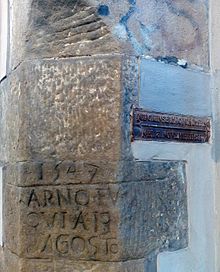
116:) floods on August 13, 1547 (left) and November 3, 1844 (metal plate on the right). Photographed in Via delle Casine.
88:
646:
289:
124:
is a point that represents the maximum rise of a body of water over land. Such a mark is often the result of a
631:
274:
555:
490:
278:
433:
223:
621:
611:
93:
156:, this line is formed by the highest position of the tide, and moves up and down the beach on a
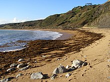
56:
641:
352:
205:
616:
133:
579:
636:
342:
329:
294:
214:
61:
464:
281:, "the Admirals power extended even to the high water mark, and into the main streams".
626:
196:
605:
285:
239:
161:
149:
77:
505:
Water
Boundaries: Demystifying Land Boundaries Adjacent to Tidal Or Navigable Waters
418:
Water
Boundaries: Demystifying Land Boundaries Adjacent to Tidal Or Navigable Waters
271:
231:
358:
347:
337:
210:
144:
and is typically composed of debris left by high tide. The area at the top of a
17:
319:
218:
are abundant in the rotting seaweed, and these invertebrates provide food for
200:
104:
584:, Court of Appeals of Indiana, Opinion 46A03-1508-PL-1116, December 7, 2016"
227:
379:
Summary of floods in the United States, January 1992 through
September 1993
113:
97:
49:
38:
30:
This article is about the height of water over land. For other uses, see
243:
188:
164:
81:
582:
Gunderson v. State of
Indiana, Indiana Department of Natural Resources
235:
192:
176:
168:
65:
405:
The Water
Dictionary: A Comprehensive Reference of Water Terminology
251:
219:
145:
129:
125:
103:
87:
71:
55:
43:
247:
172:
157:
153:
109:
152:
is deposited is an example of this phenomenon. Where there are
530:
48:
Sign indicating high water marks of different floods in
288:, the high water mark is also significant because the
37:"tide mark" redirects here. For the company, see
531:"Electronic Code of Federal Regulations (eCFR)"
535:Electronic Code of Federal Regulations (eCFR)
307:United States Environmental Protection Agency
8:
549:"USACE 2005 OHWM Regulatory Guidance Letter"
167:, but can also include a large amount of
428:
426:
370:
448:
446:
481:Gunnleyg Eldevig & Andrew Flack.
303:United States Army Corps of Engineers
7:
160:. The debris is chiefly composed of
262:One kind of high water mark is the
439:. Durham Biodiversity Partnership.
25:
403:Nancy McTigue, James M. Symons,
322:
32:High water mark (disambiguation)
27:Highest level of a body of water
461:North Cornwall District Council
187:The strandline is an important
299:Rivers and Harbors Act of 1899
1:
76:High water mark memorial at
487:Ecology of Portland Harbour
279:Admiral of the English Seas
663:
290:United States Constitution
36:
29:
264:ordinary high water mark
92:High water mark sign in
392:Thinking, Fast and Slow
355:, benches left by lakes
268:average high water mark
183:Ecological significance
117:
101:
85:
69:
53:
348:Measuring storm surge
107:
91:
75:
59:
47:
108:High water marks of
503:Bruce S. Flushman,
416:Bruce S. Flushman,
589:. 9 November 2020.
491:The Heritage Coast
258:Legal significance
195:. In parts of the
118:
102:
86:
70:
60:The strandline at
54:
647:Vertical position
516:Nathaniel Bacon,
390:Daniel Kahneman,
353:Terrace (geology)
206:Talitrus saltator
191:for a variety of
158:fortnightly cycle
16:(Redirected from
654:
591:
590:
588:
576:
570:
569:
567:
566:
560:
554:. Archived from
553:
545:
539:
538:
527:
521:
514:
508:
501:
495:
494:
478:
472:
471:
469:
463:. Archived from
458:
450:
441:
440:
438:
430:
421:
414:
408:
401:
395:
388:
382:
375:
332:
327:
326:
325:
21:
662:
661:
657:
656:
655:
653:
652:
651:
602:
601:
600:
595:
594:
586:
578:
577:
573:
564:
562:
558:
551:
547:
546:
542:
529:
528:
524:
515:
511:
502:
498:
480:
479:
475:
467:
456:
454:"Strandlliines"
452:
451:
444:
436:
432:
431:
424:
415:
411:
407:(2011), p. 284.
402:
398:
394:(2011), p. 137.
389:
385:
376:
372:
367:
343:Mean high water
330:Wetlands portal
328:
323:
321:
318:
295:Clean Water Act
260:
215:Coelopa frigida
185:
175:at sea or from
122:high water mark
62:Ringstead Beach
42:
35:
28:
23:
22:
18:High-water mark
15:
12:
11:
5:
660:
658:
650:
649:
644:
639:
634:
629:
624:
619:
614:
604:
603:
599:
598:External links
596:
593:
592:
571:
540:
522:
520:(1651), p. 44.
509:
507:(2001), p. 72.
496:
473:
470:on 2007-10-18.
442:
422:
420:(2001), p. 73.
409:
396:
383:
369:
368:
366:
363:
362:
361:
356:
350:
345:
340:
334:
333:
317:
314:
259:
256:
197:United Kingdom
184:
181:
171:, either from
26:
24:
14:
13:
10:
9:
6:
4:
3:
2:
659:
648:
645:
643:
640:
638:
635:
633:
632:Riparian zone
630:
628:
625:
623:
620:
618:
615:
613:
610:
609:
607:
597:
585:
583:
575:
572:
561:on 2012-10-07
557:
550:
544:
541:
536:
532:
526:
523:
519:
513:
510:
506:
500:
497:
492:
488:
484:
483:"Strand Line"
477:
474:
466:
462:
455:
449:
447:
443:
435:
429:
427:
423:
419:
413:
410:
406:
400:
397:
393:
387:
384:
380:
374:
371:
364:
360:
357:
354:
351:
349:
346:
344:
341:
339:
336:
335:
331:
320:
315:
313:
310:
308:
304:
300:
296:
291:
287:
286:United States
282:
280:
276:
273:
269:
265:
257:
255:
253:
249:
245:
241:
237:
233:
229:
225:
221:
217:
216:
212:
208:
207:
202:
198:
194:
190:
182:
180:
178:
174:
170:
166:
163:
159:
155:
151:
147:
143:
137:
135:
131:
127:
123:
115:
111:
106:
99:
95:
90:
83:
79:
78:Lake Missoula
74:
67:
63:
58:
51:
46:
40:
33:
19:
581:
574:
563:. Retrieved
556:the original
543:
534:
525:
517:
512:
504:
499:
486:
476:
465:the original
434:"Strandline"
417:
412:
404:
399:
391:
386:
378:
373:
311:
283:
267:
263:
261:
232:pied wagtail
222:such as the
213:
204:
186:
141:
138:
121:
119:
359:Wash margin
338:Chart datum
240:brown hares
220:shore birds
211:seaweed fly
201:sandhoppers
94:Bisset Park
606:Categories
565:2012-10-10
365:References
275:boundaries
224:rock pipit
179:outflows.
142:strandline
622:Hydrology
612:Surveying
228:turnstone
642:Wetlands
316:See also
272:property
238:such as
209:and the
203:such as
114:Florence
98:Virginia
50:Missouri
39:Tidemark
617:Beaches
284:In the
236:mammals
193:animals
189:habitat
165:seaweed
162:rotting
112:river (
82:Montana
637:Rivers
305:, the
234:, and
177:sewage
169:litter
150:debris
148:where
100:, U.S.
84:, U.S.
66:Dorset
52:, U.S.
627:Lakes
587:(PDF)
559:(PDF)
552:(PDF)
468:(PDF)
457:(PDF)
437:(PDF)
248:voles
244:foxes
173:ships
154:tides
146:beach
130:Egypt
126:flood
252:mice
250:and
230:and
134:sign
110:Arno
68:, UK
266:or
608::
533:.
489:.
485:.
459:.
445:^
425:^
254:.
246:,
242:,
226:,
199:,
120:A
96:,
80:,
64:,
580:"
568:.
537:.
493:.
41:.
34:.
20:)
Text is available under the Creative Commons Attribution-ShareAlike License. Additional terms may apply.