103:
81:
111:
119:
89:
860:
848:
826:
127:
209:, where the road is at 119 metres high. Further north, past the cold store, the width of the road narrows. The section of road from the A1 was widened and straightened in 1969 when the cold store was built.
407:
to the west, and North
Rauceby. The road levels out at around a height of 85 metres, and passes Ermine Street Farm to the right. There is a staggered junction and the B6403 finishes at the T-junction at
1234:
378:, the main Roman town on the High Dyke, is in the south-east of the village. The road climbs out of Ancaster, becoming the South Kesteven and North Kesteven boundary all the way to the A17, with
647:
1204:
234:, near Highdike Cottages. The former High Dyke branch railway ran parallel to the High Dyke from the A1, and joined the East Coast Main Line here. There is a right turn for
485:. The alignment is still clear, and to the West of the runways it is used as a housing estate road, before losing its identity south of Bracebridge Heath, around
344:. There is a right turn for Wilsford, and the road is the boundary between Ancaster and South Kesteven, to the east, and with North Kesteven. At Duke's Covert (
1254:
1249:
255:, it passes Ponton Park Wood to the left where the road reaches 118 metres high, and passes through Woodnook, where there is a left turn for
1244:
1224:
1182:
892:
487:
481:
471:
457:
435:
418:
388:
346:
301:
283:
269:
251:
226:
181:
171:
475:, 75m above sea level). It is maintained, on a variety of road types, across Coleby Heath and Harmston Heath. The track is interrupted by
150:
102:
655:
1259:
80:
68:. High Dyke is also a name for the general area between Easton and Great Ponton. On the Ordnance Survey 1:25000 sheets it is spelled
216:. It passes Highdyke Farm to the right, and the road descends and is crossed by a 400 kV overhead line that runs parallel to the
1462:
1264:
566:
537:
260:
830:
1472:
1467:
1347:
138:
in 2008 has included construction of a grade-separated road crossing in place of the disused railway bridge that was part of the
1482:
1363:
1274:
1229:
1477:
902:
110:
1359:
838:
1279:
1415:
135:
61:
45:
1419:
1057:
885:
433:
on the OS maps, as the route of the Viking Way. It is a footpath until it crosses Long Lane on
Leadenham Heath at
246:
95:
1284:
1214:
1209:
1099:
1239:
1007:
371:
351:
399:, where the road is more north–south aligned, north of Ancaster. There is a right turn for North Rauceby. The
1411:
1383:
1269:
1174:
1022:
923:
404:
162:
1154:
1144:
964:
532:(Map) (A1 ed.). 1:25 000. OS Explorer. Ordnance survey of Great Britain. 3 January 2006. § 247.
359:
337:
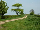
118:
49:
34:
1052:
878:
864:
561:(Map) (A1 ed.). 1:25 000. OS Explorer. Ordnance survey of Great Britain. 7 April 2006. § 272.
194:
1199:
1164:
1047:
1012:
1002:
992:
355:
317:
217:
202:
65:
615:
603:
1104:
375:
296:
153:
east of
Grantham, but all other junctions are conventional grade-level crossroads or T junctions.
1431:
1423:
1407:
1387:
1319:
1219:
997:
928:
413:
341:
230:. There is a left turn before the bridge for Great Ponton, and a right turn after the bridge for
259:. From here to almost Ancaster, the road becomes the boundary of several parishes starting with
88:
56:. It is also the name of a small settlement on that road, 1 mile (1.6 km) south-east from
1443:
1395:
1335:
1303:
1087:
944:
562:
533:
53:
1307:
1299:
1093:
954:
677:
1379:
1367:
466:
235:
143:
582:
295:. Along an avenue of trees the road becomes the parish boundary of Harrowby Without, and
1391:
1355:
1351:
1339:
1114:
1027:
969:
959:
852:
476:
333:
329:
213:
186:
17:
189:
to the right, and the 18-acre Easton Cold Store, built in the late 1960s, and run by
1456:
1435:
1399:
1375:
1159:
1124:
500:
396:
379:
299:, to the east. At this point the road reaches it highest point of 125 metres at
256:
231:
198:
190:
176:
37:
870:
1331:
1327:
1323:
1315:
1169:
1119:
974:
949:
908:
448:
367:
320:, to the west, and Welby. The road gently descends and rises up to a left turn for
310:
288:
239:
221:
166:
57:
41:
1109:
1037:
409:
278:
264:
1371:
1343:
1129:
1077:
452:
400:
313:, and the road gently descends to a right turn for Welby at Pyewipe Cottages.
292:
161:
The modern route begins as the B6403 at the grade-separated junction with the
1082:
795:
769:
699:
363:
743:
725:
628:
825:
1427:
1403:
1139:
1134:
1072:
1062:
1042:
616:"The High Dyke Branch and iron ore lines after BR a preservation attempt"
403:
joins from the east, and follows the road, where the boundary is between
325:
274:
197:. When built, and throughout the 1970s it was thought to be the largest
1439:
1149:
1067:
1032:
462:
425:
The Line of the Roman Road
Continues to the North, still labelled both
206:
126:
447:
throughout the route. It continues northwards across Temple Heath at
122:
High Dike, the route of Ermine Street, North-East of
Boothby Graffoe
1017:
125:
117:
109:
101:
87:
79:
874:
395:
At
Sudbrook House it becomes the boundary between Ancaster and
439:, where it becomes a minor road. Close to this crossroads is
392:
where the road crosses a small river at 60 m altitude.
267:
to the right. On
Spittlegate Heath there is a roundabout at
443:, the spelling in contrast to the Ordnance Survey's use of
328:
Heath. At this point the road becomes the boundary between
648:"Millions poured into Norbert Dentressangle's Easton site"
316:
At Welby
Pastures the road becomes the boundary between
273:
where the road briefly becomes the A52. To the west is
836:
98:
94:
This is part of the descent from Stoke Tunnel, where
1192:
983:
937:
916:
185:), and runs north–south. There is a right turn for
455:the alignment turns slightly more to the north at
416:. The Roman alignment is slightly to the west at
382:to the east. There is a dip in the road known as
146:used to export iron ore between 1916 and 1973.
92:The East Coast Main Line crosses Ermine Street.
886:
559:Lincoln: Sleaford, Metheringham & Navenby
134:Recent rebuilding of the A1 road junction at
8:
451:and across Wellingore Heath. Just east of
291:, and the High Dyke continues ahead as the
224:there is a railway bridge for the ECML, at
893:
879:
871:
629:"Christian Salvesen's 'Easton Cold Store'"
33:is a minor road following a length of the
604:"The High Dyke Branch in latter BR days"
366:at traffic lights, and passes under the
287:), the A52 deviates to the right toward
175:). At Easton Farm, it meets the line of
843:
618:, Flickr.com. Retrieved 24 October 2011
606:, Flickr.com. Retrieved 24 October 2011
553:
551:
549:
530:Grantham: Bottesford & Colsterworth
524:
522:
520:
518:
516:
512:
309:to the right. There is a left turn for
1183:List of civil parishes in Lincolnshire
744:"Ermine Street (from railway bridge)"
635:. Geograph project. 19 November 2006.
201:in Europe. To the left is a turn for
151:Prince William of Gloucester Barracks
84:New bridge over the A1 at Woolsthorpe
7:
700:"The B6403, High Dike joins the A52"
27:Minor road in Lincolnshire, England
149:There is a roundabout adjacent to
25:
732:. Geograph project. 25 July 2006.
261:Londonthorpe and Harrowby Without
858:
846:
824:
776:. Geograph project. 19 July 2010
706:. Geograph project. 12 June 2012
350:, 92 m elevation) it meets
1364:Grimsby Fishing Heritage Centre
750:. Geograph project. 1 June 2007
332:and Barkston, to the west, and
796:"Ermine Street (Coleby heath)"
340:, to the east. To the left is
106:Between Londonthorpe and Welby
1:
680:. Historic Houses Association
646:Addy, Rod (29 October 2009).
358:, and the road descends into
1205:Parliamentary constituencies
1416:Museum of Lincolnshire Life
277:(A52), and to the right is
136:Woolsthorpe-by-Colsterworth
46:Woolsthorpe-by-Colsterworth
1499:
1312:History and notable places
1255:Grade II* listed buildings
281:(B1176). At Cold Harbour (
247:Little Ponton and Stroxton
1293:
585:. National Railway Museum
491:still at 75 m high.
212:There is a left turn for
130:High Dyke on Coleby Heath
40:in the English county of
1463:Villages in Lincolnshire
1250:Grade I listed buildings
372:Ancaster railway station
52:, and onwards nearly to
1473:North Kesteven District
1468:South Kesteven District
1420:St James' Church, Louth
1412:Market Rasen Racecourse
924:North East Lincolnshire
831:High Dyke, Lincolnshire
678:"Easton walled gardens"
479:on Waddington Heath at
60:, near to the mouth of
18:High Dyke, Lincolnshire
1483:Roman roads in England
131:
123:
115:
107:
99:
85:
1478:Roads in Lincolnshire
1296:Historic subdivisions
938:Boroughs or districts
800:OS grid square SK9860
774:OS grid square SK9845
748:OS grid square SK9844
730:OS grid square SK9638
704:OS grid square SK9534
652:Foodmanufacture.co.uk
633:OS grid square SK9426
461:, and continues past
207:Easton Walled Gardens
195:Norbert Dentressangle
129:
121:
113:
105:
91:
83:
1165:Wainfleet All Saints
833:at Wikimedia Commons
658:on 28 September 2011
238:and a left turn for
218:East Coast Main Line
66:East Coast Main Line
1440:Winceby Battlefield
1384:Kinema in the Woods
1260:Scheduled monuments
986:(cities in italics)
917:Unitary authorities
376:Ancaster Roman Town
1424:Tattershall Castle
1408:Lincolnshire Coast
1388:Kingdom of Lindsey
1320:Bolingbroke Castle
998:Barton-upon-Humber
929:North Lincolnshire
726:"Pyewipe cottages"
342:RAF Barkston Heath
132:
124:
116:
108:
100:
86:
1450:
1449:
1444:Woolsthorpe Manor
1404:Lincolnshire Fens
1396:Lincoln Cathedral
1336:Cross Keys Bridge
1088:Kirton in Lindsey
984:Major settlements
903:Ceremonial county
829:Media related to
802:. 24 October 2011
362:. It crosses the
114:North of Ancaster
54:Bracebridge Heath
16:(Redirected from
1490:
1275:Lord Lieutenants
911:
905:
895:
888:
881:
872:
863:
862:
861:
851:
850:
849:
842:
828:
812:
811:
809:
807:
792:
786:
785:
783:
781:
766:
760:
759:
757:
755:
740:
734:
733:
722:
716:
715:
713:
711:
696:
690:
689:
687:
685:
674:
668:
667:
665:
663:
654:. Archived from
643:
637:
636:
625:
619:
613:
607:
601:
595:
594:
592:
590:
579:
573:
572:
555:
544:
543:
526:
490:
484:
474:
469:to Coleby Mill (
460:
438:
421:
391:
349:
304:
286:
272:
263:to the left and
254:
229:
184:
179:from the south (
174:
140:High Dyke branch
21:
1498:
1497:
1493:
1492:
1491:
1489:
1488:
1487:
1453:
1452:
1451:
1446:
1380:Isle of Axholme
1368:Grimsby Minster
1360:Gibraltar Point
1310:
1289:
1225:Monastic houses
1188:
1177:
985:
979:
933:
912:
907:
901:
899:
869:
859:
857:
847:
845:
837:
821:
816:
815:
805:
803:
794:
793:
789:
779:
777:
768:
767:
763:
753:
751:
742:
741:
737:
724:
723:
719:
709:
707:
698:
697:
693:
683:
681:
676:
675:
671:
661:
659:
645:
644:
640:
627:
626:
622:
614:
610:
602:
598:
588:
586:
581:
580:
576:
569:
557:
556:
547:
540:
528:
527:
514:
509:
497:
486:
480:
470:
467:Boothby Graffoe
456:
434:
417:
387:
345:
300:
282:
268:
250:
236:Boothby Pagnell
225:
180:
170:
159:
144:mineral railway
93:
78:
28:
23:
22:
15:
12:
11:
5:
1496:
1494:
1486:
1485:
1480:
1475:
1470:
1465:
1455:
1454:
1448:
1447:
1392:Lincoln Castle
1356:Freiston Shore
1352:Frampton Marsh
1340:Crowland Abbey
1294:
1291:
1290:
1288:
1287:
1282:
1277:
1272:
1267:
1262:
1257:
1252:
1247:
1245:Country Houses
1242:
1237:
1232:
1227:
1222:
1217:
1212:
1207:
1202:
1196:
1194:
1190:
1189:
1187:
1186:
1172:
1167:
1162:
1157:
1152:
1147:
1142:
1137:
1132:
1127:
1122:
1117:
1115:Market Deeping
1112:
1107:
1102:
1097:
1090:
1085:
1080:
1075:
1070:
1065:
1060:
1055:
1050:
1045:
1040:
1035:
1030:
1028:Burgh le Marsh
1025:
1020:
1015:
1010:
1005:
1000:
995:
989:
987:
981:
980:
978:
977:
972:
970:South Kesteven
967:
962:
960:North Kesteven
957:
952:
947:
941:
939:
935:
934:
932:
931:
926:
920:
918:
914:
913:
900:
898:
897:
890:
883:
875:
868:
867:
865:United Kingdom
855:
835:
834:
820:
819:External links
817:
814:
813:
787:
761:
735:
717:
691:
669:
638:
620:
608:
596:
574:
567:
545:
538:
511:
510:
508:
505:
504:
503:
496:
493:
477:RAF Waddington
441:High Dyke Farm
334:North Kesteven
330:South Kesteven
214:Stoke Rochford
187:Burton Coggles
158:
155:
77:
74:
26:
24:
14:
13:
10:
9:
6:
4:
3:
2:
1495:
1484:
1481:
1479:
1476:
1474:
1471:
1469:
1466:
1464:
1461:
1460:
1458:
1445:
1441:
1437:
1436:Usher Gallery
1433:
1429:
1425:
1421:
1417:
1413:
1409:
1405:
1401:
1400:Lincoln Cliff
1397:
1393:
1389:
1385:
1381:
1377:
1376:Humber Bridge
1373:
1369:
1365:
1361:
1357:
1353:
1349:
1345:
1341:
1337:
1333:
1329:
1325:
1321:
1317:
1313:
1309:
1305:
1301:
1297:
1292:
1286:
1283:
1281:
1280:High Sheriffs
1278:
1276:
1273:
1271:
1268:
1266:
1263:
1261:
1258:
1256:
1253:
1251:
1248:
1246:
1243:
1241:
1238:
1236:
1233:
1231:
1228:
1226:
1223:
1221:
1218:
1216:
1213:
1211:
1208:
1206:
1203:
1201:
1198:
1197:
1195:
1191:
1185:
1184:
1180:
1176:
1173:
1171:
1168:
1166:
1163:
1161:
1160:Sutton-on-Sea
1158:
1156:
1153:
1151:
1148:
1146:
1143:
1141:
1138:
1136:
1133:
1131:
1128:
1126:
1125:North Hykeham
1123:
1121:
1118:
1116:
1113:
1111:
1108:
1106:
1103:
1101:
1098:
1096:
1095:
1091:
1089:
1086:
1084:
1081:
1079:
1076:
1074:
1071:
1069:
1066:
1064:
1061:
1059:
1056:
1054:
1051:
1049:
1046:
1044:
1041:
1039:
1036:
1034:
1031:
1029:
1026:
1024:
1021:
1019:
1016:
1014:
1011:
1009:
1006:
1004:
1001:
999:
996:
994:
991:
990:
988:
982:
976:
973:
971:
968:
966:
965:South Holland
963:
961:
958:
956:
953:
951:
948:
946:
943:
942:
940:
936:
930:
927:
925:
922:
921:
919:
915:
910:
904:
896:
891:
889:
884:
882:
877:
876:
873:
866:
856:
854:
844:
840:
832:
827:
823:
822:
818:
801:
797:
791:
788:
775:
771:
765:
762:
749:
745:
739:
736:
731:
727:
721:
718:
705:
701:
695:
692:
679:
673:
670:
657:
653:
649:
642:
639:
634:
630:
624:
621:
617:
612:
609:
605:
600:
597:
584:
578:
575:
570:
568:9780319238202
564:
560:
554:
552:
550:
546:
541:
539:9780319238332
535:
531:
525:
523:
521:
519:
517:
513:
506:
502:
501:Ermine Street
499:
498:
494:
492:
489:
483:
478:
473:
468:
464:
459:
454:
450:
446:
442:
437:
432:
428:
427:Ermine Street
423:
420:
415:
411:
406:
402:
398:
397:North Rauceby
393:
390:
385:
381:
380:South Rauceby
377:
373:
369:
365:
361:
357:
353:
348:
343:
339:
335:
331:
327:
323:
319:
314:
312:
308:
307:Harrowby Lane
303:
298:
294:
290:
285:
280:
276:
271:
266:
262:
258:
257:Little Ponton
253:
248:
243:
241:
237:
233:
232:Bassingthorpe
228:
223:
219:
215:
210:
208:
204:
200:
196:
192:
191:XPO Logistics
188:
183:
178:
177:Ermine Street
173:
168:
164:
156:
154:
152:
147:
145:
141:
137:
128:
120:
112:
104:
97:
90:
82:
75:
73:
71:
67:
63:
59:
55:
51:
47:
43:
39:
38:Ermine Street
36:
32:
19:
1332:Cadwell Park
1328:Bourne Abbey
1324:Boston Stump
1316:Belton House
1311:
1295:
1181:
1178:
1170:Woodhall Spa
1120:Market Rasen
1092:
1058:Gainsborough
975:West Lindsey
950:East Lindsey
909:Lincolnshire
804:. Retrieved
799:
790:
778:. Retrieved
773:
770:"The Hollow"
764:
752:. Retrieved
747:
738:
729:
720:
708:. Retrieved
703:
694:
682:. Retrieved
672:
660:. Retrieved
656:the original
651:
641:
632:
623:
611:
599:
587:. Retrieved
583:"Mallard 75"
577:
558:
529:
449:Temple Bruer
444:
440:
430:
426:
424:
410:Byard's Leap
394:
383:
368:Poacher Line
324:named after
321:
315:
311:Londonthorpe
306:
289:Threekingham
244:
240:Great Ponton
222:Great Ponton
211:
167:Colsterworth
160:
148:
139:
133:
69:
62:Stoke Tunnel
58:Great Ponton
44:, between
42:Lincolnshire
30:
29:
1110:Mablethorpe
1100:Long Sutton
1038:Cleethorpes
352:King Street
279:Old Somerby
265:Old Somerby
193:, formerly
1457:Categories
1372:Haxey Hood
1344:Donna Nook
1130:Scunthorpe
1078:Horncastle
1008:Bottesford
806:3 December
780:3 December
754:3 December
710:3 December
684:3 December
662:24 October
507:References
453:Wellingore
401:Viking Way
384:The Hollow
322:Heath Lane
305:, meeting
199:cold store
35:Roman Road
1432:The Wolds
1285:Transport
1265:Windmills
1215:Geography
1210:Education
1179:See also:
1175:Winterton
1083:Immingham
1023:Broughton
445:High Dike
431:High Dike
412:with the
405:Normanton
76:Junctions
70:High Dike
31:High Dyke
1428:The Wash
1348:Far Ings
1304:Kesteven
1240:Politics
1155:Stamford
1145:Spalding
1140:Sleaford
1135:Skegness
1073:Holbeach
1063:Grantham
1043:Crowland
495:See also
488:SK981652
482:SK985626
472:SK989600
458:SK994564
436:SK991517
419:SK989494
389:SK986452
360:Ancaster
347:SK979425
338:Wilsford
326:Barkston
302:SK956364
284:SK950347
275:Grantham
270:SK948340
252:SK942317
227:SK939292
205:and the
182:SK937261
172:SK930249
50:Ancaster
1308:Lindsey
1300:Holland
1270:History
1230:Museums
1220:Diocese
1150:Spilsby
1094:Lincoln
1068:Grimsby
1053:Epworth
1033:Caistor
955:Lincoln
853:England
839:Portals
463:Navenby
96:Mallard
64:on the
1193:Topics
1048:Crowle
1013:Bourne
1003:Boston
993:Alford
945:Boston
589:2 July
565:
536:
356:Bourne
318:Syston
203:Easton
1235:SSSIs
1105:Louth
1018:Brigg
465:and
386:, at
354:from
297:Welby
293:B6403
220:. At
157:Route
1200:Flag
808:2013
782:2013
756:2013
712:2013
686:2013
664:2011
591:2013
563:ISBN
534:ISBN
429:and
364:A153
336:and
142:, a
48:and
906:of
414:A17
374:.
370:at
245:At
165:at
1459::
1442:,
1438:,
1434:,
1430:,
1426:,
1422:,
1418:,
1414:,
1410:,
1406:,
1402:,
1398:,
1390:,
1386:,
1382:,
1378:,
1374:,
1370:,
1366:,
1362:,
1358:,
1354:,
1350:,
1346:,
1342:,
1338:,
1334:,
1330:,
1326:,
1322:,
1318:,
1314::
1306:,
1302:,
1298::
798:.
772:.
746:.
728:.
702:.
650:.
631:.
548:^
515:^
422:.
249:,
242:.
163:A1
72:.
1394:,
894:e
887:t
880:v
841::
810:.
784:.
758:.
714:.
688:.
666:.
593:.
571:.
542:.
169:(
20:)
Text is available under the Creative Commons Attribution-ShareAlike License. Additional terms may apply.