184:
196:
224:
38:
49:
208:
305:
329:
317:
265:
30:
22:
273:
much longer than it once was, and Baker Street has a different course. Some existing buildings were retained on the canal side or incorporated into the shopping centre. These include listed buildings Pillar and Lucy
Warehouses (c.1838), Sudbrooke House (1840s), Llanthony Provender Mill (1862), and Downings Malthouse (1893).
183:
272:
Most of High
Orchard was redeveloped as Gloucester Quays shopping centre and associated buildings in the early 2000s. The surviving streets are High Orchard Street, Baker Street, Church Street, Llanthony Road, Southgate Street, and Merchants' Road. St Luke's Street no longer exists, Church Street is
231:
In July 1912, a fire broke out at J. A. Matthew & Co. in High
Orchard Street and Llanthony Road that destroyed a 400ft long factory and nine houses in High Orchard Street. It also seriously damaged six houses in Exhibition Street. The fire was visible from
149:
The area was centred on High
Orchard Street which ran between Llanthony Road to the north and Baker Street to the south. Other streets were Merchants' Street which ran parallel to High Orchard Street, St Luke's Street, and Church Street.
195:
157:
built a branch line from the city station to High
Orchard immediately south of Baker Street, and which ran north through the area's industrial buildings into Gloucester Docks. South of the branch line was the works of the
125:
which benefited from the opening of the
Gloucester and Sharpness Canal in 1827 and, from 1848, new railway connections. Firms imported timber, prepared it for the building industry, and preserved it by
304:
207:
177:
and consecrated in 1841. There was also a
Norwegian Chapel immediately south of the railway line, and a Mission Room on the corner of Llanthony Road and Southgate Street.
236:, and was extinguished by fire fighters from Stroud and Cheltenham as the Gloucester engine was out of action. Over 200 men were made unemployed as a result of the fire.
1013:
223:
159:
279:
Other listed buildings along
Llanthony Road and Southgate Street are St Lukes House, the Mariners Hall, 172 Southgate Street, and 182/184 Southgate Street.
276:
Llanthony
Provender Mill was seriously damaged in an arson attack in 2015 which left it a "dilapidated shell". It was subsequently rebuilt as luxury flats.
37:
245:, an agricultural co-operative, owned buildings at Baker's Quay (1955) and a former maltings (1983) at High Orchard, and in 1983 employed 383 people.
48:
916:
768:
383:
242:
97:
shopping centre and associated buildings, with some original buildings surviving as part of the shopping centre and along the canal side.
345:
753:
883:
852:
821:
790:
732:
701:
670:
639:
608:
577:
538:
904:
499:
82:
It was centred on High
Orchard Street which ran between Llanthony Road to the north and Baker Street to the south. To the west was
316:
878:
847:
816:
785:
727:
696:
665:
634:
603:
572:
964:
253:
189:
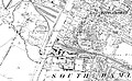
1805 map of Gloucester after the construction of the Gloucester and Sharpness Canal but before the development of High Orchard
462:
239:
A carpet manufacturer moved to the area in the late 1930s and by 1975 there was a carpet factory there employing 250 people.
170:
72:
489:
282:
In 2017, the last four surviving dockers' cottages (1902) in High Orchard Street were released for sale after renovation.
1003:
328:
146:. The cabinet makers J. A. Matthew & Co. built a large manufactory in 1894 that was destroyed by fire in 1912.
1008:
452:
233:
940:
252:
from the building, much of it German or Dutch of the fifteenth to the eighteenth centuries, was reused at
291:
928:
83:
514:
295:
139:
76:
268:
High Orchard Street in the Gloucester Quays development with former Matthews factory on the right
407:
376:
201:
High Orchard on an 1880s Ordnance Survey map showing timber yards on the east bank of the canal
495:
458:
166:
121:
The area was developed in the 19th century, and from the 1830s was particularly known for its
106:
90:. Immediately south of Baker Street was the terminus of the High Orchard branch railway line.
64:
931:
Hugh Conway-Jones, Gloucester Docks & the Sharpness Canal, 2008. Retrieved 22 March 2019.
874:
843:
812:
781:
723:
692:
661:
630:
599:
568:
555:
435:
227:
High Orchard Street (looking north), aftermath of the J.A. Matthews & Co fire, July 1912
174:
127:
94:
87:
68:
394:
378:
The Docks Conservation Area (Conservation Area No. 3) Appraisal & Management Proposals
154:
138:
machinery was made at High Orchard Works (1851), while Atlas Works (1860) was the home of
63:
in England that was developed in the 19th century on the former orchard of the Priory of
264:
997:
249:
956:
907:
Daniel Chipperfield, Gloucestershire Live, 4 August 2017. Retrieved 21 March 2019.
756:
Daniel Chipperfield, Gloucestershire Live, 20 April 2017. Retrieved 22 March 2019.
769:
Gloucester's most exclusive flats unveiled - and they look completely different.
122:
771:
Daniel Chipperfield, Gloucestershire Live, 12 May 2018. Retrieved 4 April 2019.
143:
60:
979:
966:
290:
High Orchard has two bridges that cross the Gloucester and Sharpness Canal;
135:
29:
21:
905:
Take a look inside old dockers' cottages transformed for the 21st century.
131:
110:
109:, founded in 1136 by monks in Wales who retreated to Gloucester and
263:
222:
79:'s Atlas Works and a number of other significant local employers.
47:
36:
28:
20:
453:
Gloucester in Old Photographs: From the County Library Collection
142:
who made industrial machinery with a specialism in heavy-duty
105:
High Orchard was sited on the former orchard of the Priory of
754:
Arson pair cheered as they torched historic Gloucester mill.
298:(2008) in the south on the newly constructed St Ann Way.
310:
Llanthony Road Bridge looking east along Llanthony Road
556:
Gloucester, 1835-1985: Economic development 1914-85.
436:
Gloucester, 1835-1985: Economic development to 1914.
943:Urban Realm, 8 June 2009. Retrieved 22 March 2019.
248:The Church of St. Luke was demolished in 1934 and
165:There was a small amount of housing served by the
52:Pillar & Lucy Warehouse at Baker's Quay, 2009
558:British History Online. Retrieved 21 March 2019.
517:British History Online. Retrieved 18 March 2019.
438:British History Online. Retrieved 21 March 2019.
397:British History Online. Retrieved 21 March 2019.
541:Visit Gloucestershire. Retrieved 22 March 2019.
160:Gloucester Railway Carriage and Wagon Company
134:. The flour-milling industry was present and
67:(1136). The area was closely associated with
8:
539:Even More photos of Gloucester in the 1900s.
213:High Orchard on a c.1900 Ordnance Survey map
71:immediately to the north, and served by the
382:Gloucester City Council, Gloucester, 2007.
957:High Orchard before and after photographs.
919:Eadon Consulting. Retrieved 22 March 2019.
551:
549:
547:
75:and railway transport. It was the site of
525:
523:
431:
429:
408:"Medieval priory restoration work starts"
25:Llanthony Provender Mill, 2009, canalside
764:
762:
474:
472:
470:
93:Most of the area is now the site of the
446:
444:
357:
300:
179:
573:"Church of the Holy Trinity (1419405)"
59:was an industrial area of the city of
16:Industrial area in Gloucester, England
1014:Industrial history of Gloucestershire
113:after attacks by the local populace.
44:(1885), made by Fielding & Platt.
7:
879:"182/184 Southgate Street (1245610)"
666:"Llanthony Provender Mill (1271710)"
457:Gloucester: Alan Sutton. pp. 78-79.
491:The Branch Lines of Gloucestershire
346:Priday, Metford and Company Limited
322:Llanthony Road Bridge looking north
42:Tweddell's 150-Ton Riveting Machine
884:National Heritage List for England
853:National Heritage List for England
822:National Heritage List for England
791:National Heritage List for England
733:National Heritage List for England
702:National Heritage List for England
671:National Heritage List for England
640:National Heritage List for England
609:National Heritage List for England
578:National Heritage List for England
14:
243:West Midland Farmers' Association
848:"172 Southgate Street (1245637)"
395:Medieval Gloucester: Topography.
327:
315:
303:
206:
194:
182:
941:Bridge gives Gloucester a lift.
494:. Stroud: Amberley Publishing.
728:"Downings Malthouse (1271708)"
697:"Downings Malthouse (1271707)"
73:Gloucester and Sharpness Canal
33:Llanthony Provender Mill, 2009
1:
529:Ordnance Survey map, c. 1880.
478:Ordnance Survey map, c. 1900.
604:"Pillar Warehouse (1271711)"
635:"Sudbrooke House (1245763)"
1030:
786:"St Lukes House (1245762)"
917:High Orchard Lift Bridge.
817:"Mariners Hall (1245761)"
488:Maggs, Colin G. (2013).
367:, Vol. 60 (1885), p. 88.
515:St. Luke, High Orchard.
130:it or treating it with
980:51.858768°N 2.256072°W
294:in the north, and the
269:
228:
53:
45:
34:
26:
292:Llanthony Road Bridge
267:
226:
51:
40:
32:
24:
985:51.858768; -2.256072
929:High Orchard Bridge.
450:Voyce, Jill. (1985)
140:Fielding & Platt
77:Fielding & Platt
1004:Areas of Gloucester
976: /
334:High Orchard Bridge
296:High Orchard Bridge
254:Holy Trinity Church
414:. 14 February 2017
270:
229:
171:Church of St. Luke
54:
46:
35:
27:
167:Church of England
107:Llanthony Secunda
65:Llanthony Secunda
1021:
1009:Gloucester Docks
991:
990:
988:
987:
986:
981:
977:
974:
973:
972:
969:
944:
938:
932:
926:
920:
914:
908:
902:
896:
895:
893:
891:
875:Historic England
871:
865:
864:
862:
860:
844:Historic England
840:
834:
833:
831:
829:
813:Historic England
809:
803:
802:
800:
798:
782:Historic England
778:
772:
766:
757:
751:
745:
744:
742:
740:
724:Historic England
720:
714:
713:
711:
709:
693:Historic England
689:
683:
682:
680:
678:
662:Historic England
658:
652:
651:
649:
647:
631:Historic England
627:
621:
620:
618:
616:
600:Historic England
596:
590:
589:
587:
585:
569:Historic England
565:
559:
553:
542:
536:
530:
527:
518:
512:
506:
505:
485:
479:
476:
465:
448:
439:
433:
424:
423:
421:
419:
404:
398:
392:
386:
374:
368:
362:
331:
319:
307:
210:
198:
186:
175:Thomas Fulljames
95:Gloucester Quays
88:Southgate Street
86:and to the east
69:Gloucester Docks
1029:
1028:
1024:
1023:
1022:
1020:
1019:
1018:
994:
993:
984:
982:
978:
975:
970:
967:
965:
963:
962:
953:
948:
947:
939:
935:
927:
923:
915:
911:
903:
899:
889:
887:
873:
872:
868:
858:
856:
842:
841:
837:
827:
825:
811:
810:
806:
796:
794:
780:
779:
775:
767:
760:
752:
748:
738:
736:
722:
721:
717:
707:
705:
691:
690:
686:
676:
674:
660:
659:
655:
645:
643:
629:
628:
624:
614:
612:
598:
597:
593:
583:
581:
567:
566:
562:
554:
545:
537:
533:
528:
521:
513:
509:
502:
487:
486:
482:
477:
468:
449:
442:
434:
427:
417:
415:
406:
405:
401:
393:
389:
375:
371:
363:
359:
354:
342:
335:
332:
323:
320:
311:
308:
288:
262:
221:
214:
211:
202:
199:
190:
187:
155:Midland Railway
119:
103:
17:
12:
11:
5:
1027:
1025:
1017:
1016:
1011:
1006:
996:
995:
960:
959:
952:
951:External links
949:
946:
945:
933:
921:
909:
897:
866:
835:
804:
773:
758:
746:
715:
684:
653:
622:
591:
560:
543:
531:
519:
507:
500:
480:
466:
440:
425:
399:
387:
384:Archived here.
369:
356:
355:
353:
350:
349:
348:
341:
338:
337:
336:
333:
326:
324:
321:
314:
312:
309:
302:
287:
284:
261:
258:
256:, Longlevens.
220:
217:
216:
215:
212:
205:
203:
200:
193:
191:
188:
181:
173:, designed by
118:
115:
102:
99:
15:
13:
10:
9:
6:
4:
3:
2:
1026:
1015:
1012:
1010:
1007:
1005:
1002:
1001:
999:
992:
989:
958:
955:
954:
950:
942:
937:
934:
930:
925:
922:
918:
913:
910:
906:
901:
898:
886:
885:
880:
876:
870:
867:
855:
854:
849:
845:
839:
836:
824:
823:
818:
814:
808:
805:
793:
792:
787:
783:
777:
774:
770:
765:
763:
759:
755:
750:
747:
735:
734:
729:
725:
719:
716:
704:
703:
698:
694:
688:
685:
673:
672:
667:
663:
657:
654:
642:
641:
636:
632:
626:
623:
611:
610:
605:
601:
595:
592:
580:
579:
574:
570:
564:
561:
557:
552:
550:
548:
544:
540:
535:
532:
526:
524:
520:
516:
511:
508:
503:
501:9781445625614
497:
493:
492:
484:
481:
475:
473:
471:
467:
464:
460:
456:
454:
447:
445:
441:
437:
432:
430:
426:
413:
409:
403:
400:
396:
391:
388:
385:
381:
379:
373:
370:
366:
361:
358:
351:
347:
344:
343:
339:
330:
325:
318:
313:
306:
301:
299:
297:
293:
285:
283:
280:
277:
274:
266:
259:
257:
255:
251:
250:stained glass
246:
244:
240:
237:
235:
225:
218:
209:
204:
197:
192:
185:
180:
178:
176:
172:
168:
163:
161:
156:
153:In 1848, the
151:
147:
145:
141:
137:
136:flour-milling
133:
129:
124:
116:
114:
112:
108:
101:Early history
100:
98:
96:
91:
89:
85:
80:
78:
74:
70:
66:
62:
58:
50:
43:
39:
31:
23:
19:
961:
936:
924:
912:
900:
888:. Retrieved
882:
869:
857:. Retrieved
851:
838:
826:. Retrieved
820:
807:
795:. Retrieved
789:
776:
749:
737:. Retrieved
731:
718:
706:. Retrieved
700:
687:
675:. Retrieved
669:
656:
644:. Retrieved
638:
625:
613:. Retrieved
607:
594:
582:. Retrieved
576:
563:
534:
510:
490:
483:
451:
416:. Retrieved
411:
402:
390:
377:
372:
365:The Engineer
364:
360:
289:
281:
278:
275:
271:
260:21st century
247:
241:
238:
230:
219:20th century
164:
152:
148:
123:timber yards
120:
117:19th century
104:
92:
84:Baker's Quay
81:
57:High Orchard
56:
55:
41:
18:
983: /
998:Categories
968:51°51′32″N
463:0862992583
352:References
144:hydraulics
61:Gloucester
971:2°15′22″W
128:kyanizing
890:21 March
859:21 March
828:21 March
797:21 March
739:21 March
708:21 March
677:21 March
646:21 March
615:21 March
584:18 March
418:21 March
412:BBC News
340:See also
132:creosote
111:Hereford
286:Bridges
234:Cranham
498:
461:
892:2019
861:2019
830:2019
799:2019
741:2019
710:2019
679:2019
648:2019
617:2019
586:2019
496:ISBN
459:ISBN
420:2019
169:'s
1000::
881:.
877:.
850:.
846:.
819:.
815:.
788:.
784:.
761:^
730:.
726:.
699:.
695:.
668:.
664:.
637:.
633:.
606:.
602:.
575:.
571:.
546:^
522:^
469:^
443:^
428:^
410:.
162:.
894:.
863:.
832:.
801:.
743:.
712:.
681:.
650:.
619:.
588:.
504:.
455:.
422:.
380:.
Text is available under the Creative Commons Attribution-ShareAlike License. Additional terms may apply.