86:
1705:
617:(Dysinger Rd., Robinson Rd., Lockport Bypass, Saunders Settlement Rd., Town Line Rd.), east-west roadway from the Royalton town line, through the town south of the city. The route then travels north on the western outskirts of the City of Lockport by the way of the Lockport Bypass onto Saunders Settlement Rd. (NY 31). The route then runs concurrently with NY 31 until NY 31's intersection with NY 270 where that route has its northern terminus. NY 93 then travels north at that intersection and onward into the Town of Cambria when NY 93 reaches NY 104.
71:
61:
412:
146:
165:
1109:) – A community bordering the east side of Lockport; primarily a residential neighborhood of detached, single family homes built in the 1920s. A typical neighborhood home is about 3 bedrooms, 1-1/2 baths approximately 1,500 sq. ft. Median age ca. 1925. Entry into the neighborhood is from Chestnut Ridge Road or Davison Road onto Windermere Road.
611:
600:
589:
578:
1211:) – A location east of the City of Lockport. The stretch of Akron Road from Lincoln Avenue northwest to the Lockport city line was settled by the Shook family approximately in the 1830s. The name began appearing on local maps in 1927, long after the last Shook owned property there, and was printed as late as 1978.
1009:
In the town, the population was spread out, with 25.3% under the age of 18, 8.3% from 18 to 24, 30.4% from 25 to 44, 24.2% from 45 to 64, and 11.9% who were 65 years of age or older. The median age was 37 years. For every 100 females, there were 96.6 males. For every 100 females age 18 and over,
1005:
living together, 10.7% had a female householder with no husband present, and 30.3% were non-families. 25.3% of all households were made up of individuals, and 8.3% had someone living alone who was 65 years of age or older. The average household size was 2.52 and the average family size was 3.03.
1288:
in South
Lockport. As of 2007, the mall was all but vacant, and demolition began in April 2011. Demolition had been mostly completed but was halted on June 9, 2011, after finding a number of federally protected baby seagulls had been nesting the roof. All that remains of the former mall is
85:
595:(Chesnut Ridge Rd.), north-south roadway that begins at Chesnut Ridge Rd./Rochester Rd. intersection just outside the City of Lockport and continues through the town for a short distance before entering the Town of Royalton.
499:, the town has a total area of 44.7 square miles (115.8 km), of which 44.6 square miles (115.6 km) is land and 0.1 square mile (0.2 km) (0.18%) is water.
1013:
The median income for a household in the town was $ 45,977, and the median income for a family was $ 55,414. Males had a median income of $ 41,166 versus $ 25,810 for females. The
584:(Saunders Settlement Rd., Chesnut Ridge Rd., Rochester Rd.), east-west highway through the town from the Cambria town line through the City of Lockport to the Royalton town line.
2239:
1633:
962:
of 2010, there were 20,529 people, 8,293 households, and 5,482 families residing in the town. There were 8,680 housing units. The racial makeup of the town was 91.1%
2254:
106:
1512:
2244:
1042:
606:(Transit Rd., Lake Ave.), north-south Highway through the town from the Amherst town line through the City of Lockport north to the Newfane town line.
389:
1626:
1428:
1879:
1826:
1788:
1715:
1676:
1362:
484:
423:
43:
399:
70:
2249:
1619:
1046:
1224:
1182:
1140:
1080:
1796:
1314:
340:
254:
247:
240:
233:
210:
60:
983:
967:
1611:
1001:(2000 Census) There were 7,537 households, out of which 33.3% had children under the age of 18 living with them, 55.4% were
1030:
975:
434:, United States. The population was 20,529 at the 2010 census. The name is derived from the series of canal locks on the
2045:
1844:
1801:
1124:
176:
2115:
2095:
2015:
1964:
1407:
987:
971:
496:
1038:
1466:
2055:
2050:
1959:
1924:
1919:
1914:
1811:
1034:
2140:
2080:
2075:
2070:
1974:
1733:
1694:
1684:
1271:
1060:
937:
922:
907:
892:
877:
862:
847:
832:
817:
802:
787:
772:
757:
742:
727:
712:
697:
682:
667:
652:
563:
454:
2130:
2125:
2110:
2100:
2025:
1939:
1929:
1909:
1869:
1643:
1262:
1214:
427:
377:
181:
138:
91:
1535:
1499:
1488:
1477:
1455:
2204:
2155:
2150:
2060:
1989:
1984:
1839:
1778:
1689:
1258:
614:
603:
592:
581:
511:
2120:
2105:
991:
1548:
2181:
2175:
2145:
2030:
1949:
1894:
1854:
1367:
529:
480:
1336:
469:
and helped make the area a bastion of anti-slavery. The Town of
Lockport was established in 1824 from
2211:
2035:
2020:
2010:
1899:
1816:
1806:
1773:
995:
350:
2234:
1969:
1753:
979:
963:
539:
2165:
1994:
1944:
1889:
1768:
1763:
1728:
1665:
1435:
557:
545:
533:
474:
443:
1381:
2135:
2090:
2065:
2004:
1999:
1979:
1954:
1864:
1834:
1748:
1743:
1723:
1266:
1014:
551:
523:
470:
1017:
for the town was $ 22,194. About 6.5% of families and 7.7% of the population were below the
2085:
1934:
1859:
1849:
1758:
1130:
431:
169:
95:
1574:
2040:
503:
204:
411:
1904:
1254:
17:
1293:
department store building, which was turned into a VA Clinic and storage cubes. A new
2228:
1536:
U.S. Geological Survey
Geographic Names Information System: Lockport (town), New York
1500:
U.S. Geological Survey
Geographic Names Information System: Lockport (town), New York
1489:
U.S. Geological Survey
Geographic Names Information System: Lockport (town), New York
1478:
U.S. Geological Survey
Geographic Names Information System: Lockport (town), New York
1456:
U.S. Geological Survey
Geographic Names Information System: Lockport (town), New York
1281:
1277:
382:
150:
1285:
1018:
439:
219:
196:
1658:
1290:
507:
435:
157:
1239:
1226:
1197:
1184:
1155:
1142:
1095:
1082:
121:
108:
331:
1121:– A location north of the City of Lockport, next to the fair grounds
1021:, including 10.8% of those under age 18 and 2.8% of those age 65 or over.
2195:‡This populated place also has portions in an adjacent county or counties
1002:
365:
1294:
466:
1127:– A location east of the City of Lockport, and north of Route 31
959:
510:
passes through the north part of the town and the City of
Lockport.
1217:– A community bordering the south side of the City of Lockport
477:, the same year the canal was completed up to the City of Lockport.
410:
357:
336:
1429:"2020 CENSUS - SCHOOL DISTRICT REFERENCE MAP: Niagara County, NY"
1357:
1297:
supercenter now lies on part of the former footprint of the mall.
610:
599:
588:
577:
1615:
1607:"For Lockportians Anywhere In The World...It's The Road Home"
453:
is in the south-central part of the county and surrounds the
1703:
1606:
1403:
1601:
1274:– Located in the north-central part of the town
2190:
2164:
1878:
1825:
1787:
1714:
1675:
1257:on the north town line, located at the junction of
398:
388:
376:
364:
347:
330:
322:
314:
306:
301:
293:
285:
277:
269:
264:
217:
202:
192:
187:
175:
156:
137:
34:
1068:Communities and locations in the Town of Lockport
1175:– A location north of the City of Lockport
1133:– A hamlet on the south border of the town
998:people of any race were 2.6% of the population.
1513:"WHAT'S IN A NAME: History, heritage, lore..."
1627:
8:
438:. The locks lift boats from the lowland of
1634:
1620:
1612:
625:
502:The south border of the town is formed by
31:
1261:(Lockport-Olcott Road / Lake Avenue) and
1043:Royalton-Hartland Central School District
1169:) – A location northwest of Rapids
2255:1824 establishments in New York (state)
2240:Buffalo–Niagara Falls metropolitan area
1337:"Population and Housing Unit Estimates"
1306:
387:
363:
329:
300:
292:
263:
230:
186:
136:
101:
82:
54:
49:
1358:"National Register Information System"
645:
571:Major highways in the Town of Lockport
566:- Town surrounds the City of Lockport.
514:marks the west town line of Lockport.
281:44.84 sq mi (116.14 km)
273:44.90 sq mi (116.28 km)
1511:Miles/milesj@gnnewspaper.com, Joyce.
1115:– North of the City of Lockport
397:
375:
346:
321:
313:
305:
284:
276:
268:
216:
201:
191:
174:
155:
7:
1363:National Register of Historic Places
1033:. Small portions of the town are in
485:National Register of Historic Places
1549:"Demolition date for Lockport Mall"
990:, and 2.1% from two or more races.
289:0.05 sq mi (0.13 km)
1642:Municipalities and communities of
1382:"Census of Population and Housing"
635:
25:
2245:Towns in Niagara County, New York
1547:Sanders, Nancy (March 29, 2011).
1047:Starpoint Central School District
1573:McKinley, David (June 9, 2011).
1516:Lockport Union-Sun & Journal
1029:Most of Lockport Town is in the
609:
598:
587:
576:
163:
144:
84:
69:
59:
1039:Newfane Central School District
29:Town in New York, United States
415:Location within Niagara County
1:
1317:. United States Census Bureau
1035:Akron Central School District
1031:Lockport City School District
326:448.10/sq mi (173.01/km)
1265:(Ridge Road), partly in the
1408:United States Census Bureau
1315:"2016 U.S. Gazetteer Files"
497:United States Census Bureau
315: • Estimate
2271:
2250:Towns in New York (state)
2200:
1701:
1656:
951:
936:
921:
906:
891:
876:
861:
846:
831:
816:
801:
786:
771:
756:
741:
726:
711:
696:
681:
666:
651:
644:
639:
634:
631:
518:Adjacent cities and towns
465:Many early settlers were
102:
83:
55:
50:
41:
1645:Niagara County, New York
1602:Town of Lockport webpage
297:630 ft (192 m)
1010:there were 94.6 males.
615:New York State Route 93
604:New York State Route 78
593:New York State Route 77
582:New York State Route 31
512:New York State Route 78
18:Highland Park, New York
1708:
1575:"Lockport Bird Rescue"
416:
2182:Tuscarora Reservation
2176:Tonawanda Reservation
1707:
1404:"U.S. Census website"
1368:National Park Service
1240:43.22250°N 78.67694°W
1198:43.15944°N 78.66306°W
1156:43.10694°N 78.66722°W
1096:43.17917°N 78.65583°W
952:U.S. Decennial Census
627:Historical population
481:Cold Springs Cemetery
414:
349: • Summer (
122:43.15056°N 78.67694°W
2213:United States portal
323: • Density
1245:43.22250; -78.67694
1236: /
1203:43.15944; -78.66306
1194: /
1161:43.10694; -78.66722
1152: /
1113:County Fair Grounds
1101:43.17917; -78.65583
1092: /
628:
239:• Darlene DiCarlo (
127:43.15056; -78.67694
118: /
1845:Niagara University
1709:
1436:U.S. Census Bureau
1125:Nottingham Estates
626:
483:was listed on the
444:Niagara Escarpment
417:
307: • Total
286: • Water
270: • Total
2222:
2221:
2116:Streeters Corners
2016:Molyneaux Corners
1370:. March 13, 2009.
1280:– A former
1252:
1220:Wrights Corners (
1210:
1168:
1108:
1015:per capita income
956:
955:
540:Town of Pendleton
495:According to the
409:
408:
278: • Land
209:Mark C. Crocker (
193: • Type
94:and the state of
16:(Redirected from
2262:
2214:
2207:
2056:Pleasant Corners
2051:Pendleton Center
1960:Gilberts Corners
1925:Comstock Corners
1920:Colonial Village
1915:Carlisle Gardens
1706:
1668:
1661:
1651:
1646:
1636:
1629:
1622:
1613:
1590:
1589:
1587:
1585:
1570:
1564:
1563:
1561:
1559:
1544:
1538:
1533:
1527:
1526:
1524:
1522:
1508:
1502:
1497:
1491:
1486:
1480:
1475:
1469:
1467:LivingPlaces.com
1464:
1458:
1453:
1447:
1446:
1444:
1442:
1433:
1425:
1419:
1418:
1416:
1414:
1400:
1394:
1393:
1391:
1389:
1378:
1372:
1371:
1354:
1348:
1347:
1345:
1343:
1333:
1327:
1326:
1324:
1322:
1311:
1272:City of Lockport
1251:
1250:
1248:
1247:
1246:
1241:
1237:
1234:
1233:
1232:
1229:
1221:
1209:
1208:
1206:
1205:
1204:
1199:
1195:
1192:
1191:
1190:
1187:
1179:
1167:
1166:
1164:
1163:
1162:
1157:
1153:
1150:
1149:
1148:
1145:
1137:
1107:
1106:
1104:
1103:
1102:
1097:
1093:
1090:
1089:
1088:
1085:
1077:
1074:Carlisle Gardens
1061:City of Lockport
984:Pacific Islander
972:African American
647:
642:
637:
629:
613:
602:
591:
580:
564:City of Lockport
558:Town of Hartland
546:Town of Royalton
534:Town of Clarence
455:City of Lockport
451:Town of Lockport
354:
168:
167:
166:
149:
148:
147:
133:
132:
130:
129:
128:
123:
119:
116:
115:
114:
111:
88:
73:
63:
51:Town of Lockport
32:
21:
2270:
2269:
2265:
2264:
2263:
2261:
2260:
2259:
2225:
2224:
2223:
2218:
2212:
2206:New York portal
2205:
2196:
2186:
2167:
2160:
2141:Warrens Corners
2076:Royalton Center
2071:Roosevelt Beach
2000:McNalls Corners
1975:Hickory Corners
1881:
1874:
1821:
1783:
1710:
1704:
1699:
1695:North Tonawanda
1671:
1666:
1659:
1652:
1649:
1644:
1640:
1598:
1593:
1583:
1581:
1572:
1571:
1567:
1557:
1555:
1546:
1545:
1541:
1534:
1530:
1520:
1518:
1510:
1509:
1505:
1498:
1494:
1487:
1483:
1476:
1472:
1465:
1461:
1454:
1450:
1440:
1438:
1431:
1427:
1426:
1422:
1412:
1410:
1402:
1401:
1397:
1387:
1385:
1380:
1379:
1375:
1356:
1355:
1351:
1341:
1339:
1335:
1334:
1330:
1320:
1318:
1313:
1312:
1308:
1304:
1267:Town of Newfane
1244:
1242:
1238:
1235:
1230:
1227:
1225:
1223:
1222:
1202:
1200:
1196:
1193:
1188:
1185:
1183:
1181:
1180:
1160:
1158:
1154:
1151:
1146:
1143:
1141:
1139:
1138:
1100:
1098:
1094:
1091:
1086:
1083:
1081:
1079:
1078:
1070:
1055:
1053:Notable natives
1027:
1003:married couples
976:Native American
640:
624:
573:
552:Town of Newfane
524:Town of Cambria
520:
504:Tonawanda Creek
493:
463:
372:
348:
260:
253:• Paul Siejak (
229:
228:
205:Town Supervisor
164:
162:
145:
143:
126:
124:
120:
117:
112:
109:
107:
105:
104:
98:
79:
78:
77:
76:
67:
66:
46:
37:
30:
23:
22:
15:
12:
11:
5:
2268:
2266:
2258:
2257:
2252:
2247:
2242:
2237:
2227:
2226:
2220:
2219:
2217:
2216:
2209:
2201:
2198:
2197:
2194:
2192:
2188:
2187:
2185:
2184:
2179:
2172:
2170:
2162:
2161:
2159:
2158:
2153:
2148:
2143:
2138:
2133:
2131:Towers Corners
2128:
2126:Terrys Corners
2123:
2118:
2113:
2111:Stella Niagara
2108:
2103:
2101:South Somerset
2098:
2093:
2088:
2083:
2078:
2073:
2068:
2063:
2058:
2053:
2048:
2043:
2038:
2033:
2028:
2026:North Hartland
2023:
2018:
2013:
2008:
2002:
1997:
1992:
1987:
1982:
1977:
1972:
1967:
1962:
1957:
1952:
1947:
1942:
1940:Dickersonville
1937:
1932:
1930:Coolidge Beach
1927:
1922:
1917:
1912:
1910:Cambria Center
1907:
1902:
1897:
1892:
1886:
1884:
1876:
1875:
1873:
1872:
1870:South Lockport
1867:
1862:
1857:
1852:
1847:
1842:
1837:
1831:
1829:
1823:
1822:
1820:
1819:
1814:
1809:
1804:
1799:
1793:
1791:
1785:
1784:
1782:
1781:
1776:
1771:
1766:
1761:
1756:
1751:
1746:
1741:
1736:
1731:
1726:
1720:
1718:
1712:
1711:
1702:
1700:
1698:
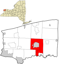
1697:
1692:
1687:
1681:
1679:
1673:
1672:
1657:
1654:
1653:
1641:
1639:
1638:
1631:
1624:
1616:
1610:
1609:
1604:
1597:
1596:External links
1594:
1592:
1591:
1579:WGRZ Channel 2
1565:
1553:WIVB Channel 4
1539:
1528:
1503:
1492:
1481:
1470:
1459:
1448:
1420:
1395:
1373:
1349:
1328:
1305:
1303:
1300:
1299:
1298:
1275:
1269:
1218:
1215:South Lockport
1212:
1176:
1170:
1134:
1128:
1122:
1116:
1110:
1069:
1066:
1065:
1064:
1054:
1051:
1026:
1023:
954:
953:
949:
948:
945:
943:
940:
934:
933:
930:
928:
925:
919:
918:
915:
913:
910:
904:
903:
900:
898:
895:
889:
888:
885:
883:
880:
874:
873:
870:
868:
865:
859:
858:
855:
853:
850:
844:
843:
840:
838:
835:
829:
828:
825:
823:
820:
814:
813:
810:
808:
805:
799:
798:
795:
793:
790:
784:
783:
780:
778:
775:
769:
768:
765:
763:
760:
754:
753:
750:
748:
745:
739:
738:
735:
733:
730:
724:
723:
720:
718:
715:
709:
708:
705:
703:
700:
694:
693:
690:
688:
685:
679:
678:
675:
673:
670:
664:
663:
660:
658:
655:
649:
648:
643:
638:
633:
623:
620:
619:
618:
607:
596:
585:
572:
569:
568:
567:
561:
555:
549:
543:
537:
527:
519:
516:
492:
489:
462:
459:
428:Niagara County
407:
406:
403:
396:
395:
392:
386:
385:
380:
374:
373:
370:
368:
362:
361:
355:
345:
344:
334:
328:
327:
324:
320:
319:
316:
312:
311:
308:
304:
303:
299:
298:
295:
291:
290:
287:
283:
282:
279:
275:
274:
271:
267:
266:
262:
261:
259:
258:
251:
246:• Pat Dufour (
244:
237:
232:• Tom Keough (
226:
225:
224:
222:
215:
214:
207:
200:
199:
194:
190:
189:
185:
184:
179:
173:
172:
160:
154:
153:
141:
135:
134:
100:
99:
92:Niagara County
89:
81:
80:
74:
68:
64:
58:
57:
56:
53:
52:
48:
47:
42:
39:
38:
35:
28:
24:
14:
13:
10:
9:
6:
4:
3:
2:
2267:
2256:
2253:
2251:
2248:
2246:
2243:
2241:
2238:
2236:
2233:
2232:
2230:
2215:
2210:
2208:
2203:
2202:
2199:
2193:
2189:
2183:
2180:
2177:
2174:
2173:
2171:
2169:
2163:
2157:
2156:Wolcottsville
2154:
2152:
2151:West Somerset
2149:
2147:
2144:
2142:
2139:
2137:
2134:
2132:
2129:
2127:
2124:
2122:
2119:
2117:
2114:
2112:
2109:
2107:
2104:
2102:
2099:
2097:
2094:
2092:
2089:
2087:
2084:
2082:
2081:St. Johnsburg
2079:
2077:
2074:
2072:
2069:
2067:
2064:
2062:
2061:Porter Center
2059:
2057:
2054:
2052:
2049:
2047:
2044:
2042:
2039:
2037:
2034:
2032:
2029:
2027:
2024:
2022:
2019:
2017:
2014:
2012:
2009:
2006:
2003:
2001:
1998:
1996:
1993:
1991:
1990:Johnson Creek
1988:
1986:
1985:Hopkins Beach
1983:
1981:
1978:
1976:
1973:
1971:
1968:
1966:
1963:
1961:
1958:
1956:
1953:
1951:
1948:
1946:
1943:
1941:
1938:
1936:
1933:
1931:
1928:
1926:
1923:
1921:
1918:
1916:
1913:
1911:
1908:
1906:
1903:
1901:
1898:
1896:
1893:
1891:
1888:
1887:
1885:
1883:
1877:
1871:
1868:
1866:
1863:
1861:
1858:
1856:
1853:
1851:
1848:
1846:
1843:
1841:
1838:
1836:
1833:
1832:
1830:
1828:
1824:
1818:
1815:
1813:
1810:
1808:
1805:
1803:
1800:
1798:
1795:
1794:
1792:
1790:
1786:
1780:
1777:
1775:
1772:
1770:
1767:
1765:
1762:
1760:
1757:
1755:
1752:
1750:
1747:
1745:
1742:
1740:
1737:
1735:
1732:
1730:
1727:
1725:
1722:
1721:
1719:
1717:
1713:
1696:
1693:
1691:
1690:Niagara Falls
1688:
1686:
1683:
1682:
1680:
1678:
1674:
1670:
1669:
1662:
1655:
1650:United States
1647:
1637:
1632:
1630:
1625:
1623:
1618:
1617:
1614:
1608:
1605:
1603:
1600:
1599:
1595:
1580:
1576:
1569:
1566:
1554:
1550:
1543:
1540:
1537:
1532:
1529:
1517:
1514:
1507:
1504:
1501:
1496:
1493:
1490:
1485:
1482:
1479:
1474:
1471:
1468:
1463:
1460:
1457:
1452:
1449:
1437:
1430:
1424:
1421:
1409:
1405:
1399:
1396:
1383:
1377:
1374:
1369:
1365:
1364:
1359:
1353:
1350:
1338:
1332:
1329:
1316:
1310:
1307:
1301:
1296:
1292:
1287:
1283:
1282:shopping mall
1279:
1278:Lockport Mall
1276:
1273:
1270:
1268:
1264:
1260:
1256:
1249:
1219:
1216:
1213:
1207:
1177:
1174:
1171:
1165:
1135:
1132:
1129:
1126:
1123:
1120:
1119:Highland Park
1117:
1114:
1111:
1105:
1075:
1072:
1071:
1067:
1063:
1062:
1057:
1056:
1052:
1050:
1048:
1044:
1040:
1036:
1032:
1024:
1022:
1020:
1016:
1011:
1007:
1004:
999:
997:
993:
989:
985:
981:
977:
973:
969:
965:
961:
950:
946:
944:
941:
939:
935:
931:
929:
926:
924:
920:
916:
914:
911:
909:
905:
901:
899:
896:
894:
890:
886:
884:
881:
879:
875:
871:
869:
866:
864:
860:
856:
854:
851:
849:
845:
841:
839:
836:
834:
830:
826:
824:
821:
819:
815:
811:
809:
806:
804:
800:
796:
794:
791:
789:
785:
781:
779:
776:
774:
770:
766:
764:
761:
759:
755:
751:
749:
746:
744:
740:
736:
734:
731:
729:
725:
721:
719:
716:
714:
710:
706:
704:
701:
699:
695:
691:
689:
686:
684:
680:
676:
674:
671:
669:
665:
661:
659:
656:
654:
650:
630:
621:
616:
612:
608:
605:
601:
597:
594:
590:
586:
583:
579:
575:
574:
570:
565:
562:
559:
556:
553:
550:
547:
544:
541:
538:
535:
531:
528:
525:
522:
521:
517:
515:
513:
509:
505:
500:
498:
490:
488:
486:
482:
478:
476:
472:
468:
460:
458:
456:
452:
447:
445:
441:
437:
433:
429:
425:
421:
413:
404:
401:
393:
391:
384:
381:
379:
369:
367:
359:
356:
352:
342:
341:Eastern (EST)
338:
335:
333:
325:
317:
309:
296:
288:
280:
272:
256:
252:
249:
245:
242:
238:
235:
231:
227:Members' List
223:
221:
218: •
212:
208:
206:
203: •
198:
195:
183:
180:
178:
171:
161:
159:
152:
151:United States
142:
140:
131:
103:Coordinates:
97:
93:
87:
72:
62:
45:
40:
33:
27:
19:
2168:reservations
2121:Sunset Beach
2106:South Wilson
1738:
1664:
1582:. Retrieved
1578:
1568:
1556:. Retrieved
1552:
1542:
1531:
1519:. Retrieved
1515:
1506:
1495:
1484:
1473:
1462:
1451:
1439:. Retrieved
1423:
1411:. Retrieved
1398:
1386:. Retrieved
1384:. Census.gov
1376:
1361:
1352:
1340:. Retrieved
1331:
1319:. Retrieved
1309:
1286:Transit Road
1253:) – A
1172:
1118:
1112:
1073:
1058:
1028:
1019:poverty line
1012:
1008:
1000:
986:, 0.6% from
957:
622:Demographics
501:
494:
479:
464:
450:
448:
440:Lake Ontario
419:
418:
220:Town Council
197:Town Council
90:Location in
26:
2146:Wendelville
2031:North Ridge
1950:East Wilson
1895:Beach Ridge
1855:Ransomville
1660:County seat
1521:November 4,
1441:November 5,
1413:January 31,
1291:The Bon-Ton
1284:located on
1243: /
1201: /
1178:Shooktown (
1159: /
1099: /
988:other races
560:- northeast
542:- southwest
530:Erie County
371:14094-14095
125: /
2235:Erie Canal
2229:Categories
2036:Orangeport
2011:Model City
1900:Blairville
1817:Youngstown
1807:Middleport
1774:Wheatfield
1302:References
1231:78°40′37″W
1228:43°13′21″N
1189:78°39′47″W
1186:43°09′34″N
1147:78°40′02″W
1144:43°06′25″N
1087:78°39′21″W
1084:43°10′45″N
958:As of the
508:Erie Canal
436:Erie Canal
402:feature ID
302:Population
188:Government
113:78°40′37″W
2191:Footnotes
2046:Pendleton
2021:Nashville
1970:Hess Road
1754:Pendleton
1558:March 29,
1173:Ridge Lea
1136:Raymond (
1025:Education
491:Geography
487:in 2004.
442:past the
390:FIPS code
378:Area code
366:ZIP codes
332:Time zone
294:Elevation
2096:Somerset
1995:Mapleton
1965:Hartland
1945:Dysinger
1890:Appleton
1802:Lewiston
1789:Villages
1769:Somerset
1764:Royalton
1739:Lockport
1734:Lewiston
1729:Hartland
1685:Lockport
1667:Lockport
992:Hispanic
982:, 0.01%
475:Royalton
432:New York
420:Lockport
394:36-43093
170:New York
110:43°9′2″N
96:New York
36:Lockport
2136:Walmore
2091:Shawnee
2066:Raymond
2005:Millers
1980:Hoffman
1955:Elberta
1882:hamlets
1865:Sanborn
1840:Newfane
1835:Gasport
1749:Niagara
1744:Newfane
1724:Cambria
1584:July 9,
1388:June 4,
1342:June 9,
1321:July 5,
1295:Walmart
978:, 1.0%
974:, 0.4%
966:, 4.8%
554:- north
536:- south
471:Cambria
467:Quakers
461:History
405:0979165
182:Niagara
139:Country
2166:Indian
2086:Sawyer
1935:Corwin
1860:Rapids
1850:Olcott
1812:Wilson
1797:Barker
1779:Wilson
1759:Porter
1677:Cities
1263:NY 104
1255:hamlet
1131:Rapids
1045:, and
996:Latino
960:census
942:20,563
927:20,529
912:19,655
897:16,596
882:12,942
797:−23.6%
722:−77.6%
702:13,523
687:12,323
677:138.7%
632:Census
548:- east
526:- west
506:. The
318:20,094
310:20,529
177:County
2041:Pekin
1880:Other
1716:Towns
1432:(PDF)
1259:NY 78
980:Asian
968:Black
964:White
917:18.4%
902:28.2%
887:58.3%
872:26.0%
867:8,177
857:64.6%
852:6,492
842:24.8%
837:3,945
827:16.2%
822:3,160
812:48.4%
807:2,720
792:1,833
782:−7.2%
777:2,399
767:−6.8%
762:2,585
752:−2.6%
747:2,773
737:−6.1%
732:2,847
717:3,032
692:35.0%
672:9,125
657:3,823
422:is a
360:(EDT)
358:UTC-4
337:UTC-5
158:State
1905:Burt
1827:CDPs
1586:2011
1560:2011
1523:2017
1443:2023
1415:2008
1390:2015
1344:2017
1323:2017
1059:See
947:0.2%
938:2020
932:4.4%
923:2010
908:2000
893:1990
878:1980
863:1970
848:1960
833:1950
818:1940
803:1930
788:1920
773:1910
758:1900
743:1890
728:1880
713:1870
707:9.7%
698:1860
683:1850
668:1840
653:1830
641:Note
636:Pop.
473:and
449:The
424:town
400:GNIS
265:Area
75:Logo
65:Flag
44:Town
994:or
970:or
426:in
383:716
351:DST
2231::
1663::
1648:,
1577:.
1551:.
1434:.
1406:.
1366:.
1360:.
1049:.
1041:,
1037:,
646:%±
532:,
457:.
446:.
430:,
2178:‡
2007:‡
1635:e
1628:t
1621:v
1588:.
1562:.
1525:.
1445:.
1417:.
1392:.
1346:.
1325:.
1076:(
662:—
353:)
343:)
339:(
257:)
255:R
250:)
248:R
243:)
241:R
236:)
234:R
213:)
211:R
20:)
Text is available under the Creative Commons Attribution-ShareAlike License. Additional terms may apply.