39:
55:
388:
62:
329:, MP. The town was recorded as diminished in 1929. The local railway station had been opened under the name of Milne, but was altered to Hilltown in 1939. The railway closed in 1984. Hilltown Post Office opened on 2 January 1914 and closed on 4 April 1985.
663:
656:
649:
302:
It was created in the 1860s when closer settlement came to the Mid-North, allowing grain farming by self-employed farmers. The government town of
Hilltown was surveyed in September 1865. The
317:
It was proposed to rename it
Yakkalo in 1916 and Milne in 1926, but neither took effect. Subsequent public infrastructure, since closed, included a railway siding and primary school. The
348:
is located in the south-west corner of the locality, on the corner of RM Williams Way and
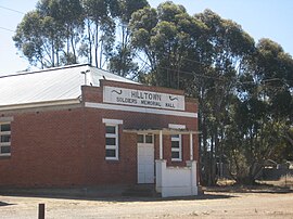
Cornwell Road. The Hilltown Soldiers' Memorial Hall is still available for community use.
182:
170:
579:
267:
54:
87:
160:
306:
at
Hilltown were sold by public auction in March 1866. Street names of the surveyed township honored pioneering pastoralists of the region such as
623:
802:
322:
980:
673:
387:
38:
918:
822:
365:
953:
897:
877:
727:
717:
847:
747:
742:
469:
948:
928:
923:
817:
80:
797:
777:
762:
712:
279:
247:
175:
892:
872:
857:
837:
827:
326:
230:
832:
887:
812:
787:
772:
752:
737:
722:
237:
215:
205:
641:
882:
852:
792:
782:
757:
707:
333:
275:
242:
210:
842:
867:
862:
807:
702:
697:
732:
692:
500:
369:
345:
222:
142:
126:
523:
687:
549:
461:
431:
318:
291:
311:
325:
which is the cadastral division in which the town was established. It was named in 1860 after Sir
959:
307:
601:
187:
933:
287:
283:
271:
29:
974:
274:. The former town centre is located on Hilltown Road, which runs north-south between
943:
938:
913:
332:
A private subdivision named Dudley formerly existed on the border of
Hilltown and
495:
102:
89:
303:
400:
282:, while the unsealed Harvey Highway connects the former town centre to
504:. Clare, SA: National Library of Australia. 14 April 1939. p. 7
645:
557:
439:
473:
438:. Government of South Australia. SA0042842. Archived from
321:
passed the town in 1922, the station was named for the
336:; it has now been subsumed into the two localities.
906:
680:
181:
169:
159:
151:
141:
133:
118:
79:
23:
194:
556:. Government of South Australia. Archived from
657:
268:District Council of Clare and Gilbert Valleys
8:
472:. 29 January 2009. SA0007587. Archived from
123:
664:
650:
642:
386:
37:
20:
426:
424:
422:
357:
462:"Placename Details: Hundred of Milne"
235:
220:
203:
196:
7:
604:. Clare and Gilbert Valleys Council
624:"Hilltown Soldiers' Memorial Hall"
14:
674:Clare and Gilbert Valleys Council
374:Australian Census 2021 QuickStats
43:Soldiers' Memorial Hall, Hilltown
370:"Hilltown (suburb and locality)"
286:. It is about 4 km east of
165:Clare and Gilbert Valley Council
61:
60:
53:
407:. Government of South Australia
366:Australian Bureau of Statistics
954:Spring Gully Conservation Park
496:"New Road from Clare to Blyth"
319:Riverton-Spalding railway line
1:
470:Government of South Australia
672:Towns and localities of the
199:Localities around Hilltown:
997:
155:348 m (1,142 ft)
466:Property Location Browser
253:
197:
193:
48:
36:
981:Towns in South Australia
554:Property Location Viewer
436:Property Location Viewer
18:Town in South Australia
405:Location SA Map Viewer
346:Clare Valley Aerodrome
528:Post Office Reference
292:Spalding railway line
266:is a locality in the
681:Towns and localities
626:. Monument Australia
312:Charles Brown Fisher
103:33.6865°S 138.6364°E
907:Geographic features
183:Federal division(s)
171:State electorate(s)
99: /
960:Mount Lofty Ranges
580:"Hilltown SA 5455"
560:on 12 October 2016
476:on 7 December 2015
442:on 12 October 2016
308:John Harris Browne
108:-33.6865; 138.6364
968:
967:
803:Polish Hill River
261:
260:
257:
256:
988:
666:
659:
652:
643:
636:
635:
633:
631:
620:
614:
613:
611:
609:
598:
592:
591:
589:
587:
576:
570:
569:
567:
565:
546:
540:
539:
537:
535:
530:. Premier Postal
520:
514:
513:
511:
509:
492:
486:
485:
483:
481:
458:
452:
451:
449:
447:
428:
417:
416:
414:
412:
401:"Hilltown, 5455"
397:
391:
390:
384:
382:
380:
368:(28 June 2022).
362:
323:Hundred of Milne
290:, on the former
195:
125:
114:
113:
111:
110:
109:
104:
100:
97:
96:
95:
92:
64:
63:
57:
41:
32:
26:
21:
996:
995:
991:
990:
989:
987:
986:
985:
971:
970:
969:
964:
934:Wakefield River
902:
676:
670:
640:
639:
629:
627:
622:
621:
617:
607:
605:
600:
599:
595:
585:
583:
578:
577:
573:
563:
561:
548:
547:
543:
533:
531:
522:
521:
517:
507:
505:
494:
493:
489:
479:
477:
460:
459:
455:
445:
443:
430:
429:
420:
410:
408:
399:
398:
394:
378:
376:
364:
363:
359:
354:
342:
300:
288:RM Williams Way
284:RM Williams Way
272:South Australia
107:
105:
101:
98:
93:
90:
88:
86:
85:
75:
74:
73:
72:
71:
70:
69:
65:
44:
30:South Australia
28:
27:
24:
19:
12:
11:
5:
994:
992:
984:
983:
973:
972:
966:
965:
963:
962:
956:
951:
946:
941:
936:
931:
926:
921:
916:
910:
908:
904:
903:
901:
900:
895:
890:
885:
880:
875:
870:
865:
860:
855:
850:
845:
840:
835:
830:
825:
823:Salter Springs
820:
815:
810:
805:
800:
795:
790:
785:
780:
775:
770:
765:
760:
755:
750:
745:
740:
735:
730:
725:
720:
715:
710:
705:
700:
695:
690:
684:
682:
678:
677:
671:
669:
668:
661:
654:
646:
638:
637:
615:
593:
571:
541:
515:
501:Northern Argus
487:
453:
418:
392:
356:
355:
353:
350:
341:
338:
299:
296:
259:
258:
255:
254:
251:
250:
245:
240:
234:
233:
228:
225:
219:
218:
213:
208:
202:
201:
191:
190:
185:
179:
178:
173:
167:
166:
163:
157:
156:
153:
149:
148:
145:
139:
138:
135:
131:
130:
120:
116:
115:
83:
77:
76:
67:
66:
59:
58:
52:
51:
50:
49:
46:
45:
42:
34:
33:
17:
13:
10:
9:
6:
4:
3:
2:
993:
982:
979:
978:
976:
961:
957:
955:
952:
950:
947:
945:
942:
940:
937:
935:
932:
930:
927:
925:
922:
920:
919:Gilbert River
917:
915:
912:
911:
909:
905:
899:
898:Woolshed Flat
896:
894:
891:
889:
886:
884:
881:
879:
878:Tothill Creek
876:
874:
871:
869:
866:
864:
861:
859:
856:
854:
851:
849:
846:
844:
841:
839:
836:
834:
831:
829:
826:
824:
821:
819:
816:
814:
811:
809:
806:
804:
801:
799:
796:
794:
791:
789:
786:
784:
781:
779:
776:
774:
771:
769:
766:
764:
761:
759:
756:
754:
751:
749:
746:
744:
741:
739:
736:
734:
731:
729:
728:Boconnoc Park
726:
724:
721:
719:
718:Black Springs
716:
714:
711:
709:
706:
704:
701:
699:
696:
694:
691:
689:
686:
685:
683:
679:
675:
667:
662:
660:
655:
653:
648:
647:
644:
625:
619:
616:
603:
597:
594:
582:. Google Maps
581:
575:
572:
559:
555:
551:
545:
542:
529:
525:
519:
516:
503:
502:
497:
491:
488:
475:
471:
467:
463:
457:
454:
441:
437:
433:
427:
425:
423:
419:
406:
402:
396:
393:
389:
375:
371:
367:
361:
358:
351:
349:
347:
339:
337:
335:
330:
328:
327:William Milne
324:
320:
315:
313:
309:
305:
297:
295:
293:
289:
285:
281:
277:
273:
269:
265:
252:
249:
246:
244:
241:
239:
236:
232:
229:
226:
224:
221:
217:
214:
212:
209:
207:
204:
200:
192:
189:
186:
184:
180:
177:
174:
172:
168:
164:
162:
158:
154:
150:
146:
144:
140:
136:
132:
128:
121:
117:
112:
84:
82:
78:
56:
47:
40:
35:
31:
22:
16:
944:Finnis Point
939:Skilly Hills
914:Clare Valley
873:Tothill Belt
848:Stanley Flat
838:Spring Gully
767:
748:Giles Corner
743:Farrell Flat
628:. Retrieved
618:
606:. Retrieved
596:
584:. Retrieved
574:
562:. Retrieved
558:the original
553:
544:
532:. Retrieved
527:
518:
506:. Retrieved
499:
490:
478:. Retrieved
474:the original
465:
456:
444:. Retrieved
440:the original
435:
409:. Retrieved
404:
395:
377:. Retrieved
373:
360:
343:
331:
316:
301:
263:
262:
198:
15:
949:Peters Hill
833:Spring Farm
818:Saddleworth
630:16 February
608:16 February
586:16 February
564:16 February
534:16 February
508:19 February
480:18 February
446:16 February
411:16 February
143:Postcode(s)
134:Established
106: /
94:138°38′11″E
81:Coordinates
929:Hutt River
924:Hill River
798:Penwortham
778:Leasingham
763:Hill River
753:Gillentown
713:Benbournie
524:"Hilltown"
432:"Hilltown"
352:References
304:first lots
280:Hill River
248:Hill River
119:Population
91:33°41′11″S
958:Northern
893:Watervale
858:Stockport
828:Sevenhill
231:Gum Creek
152:Elevation
975:Category
888:Waterloo
853:Steelton
813:Riverton
788:Marrabel
773:Hoyleton
768:Hilltown
738:Emu Flat
723:Bungaree
550:"Dudley"
340:Features
264:Hilltown
238:Bungaree
227:Hilltown
216:Leighton
206:Euromina
68:Hilltown
25:Hilltown
883:Undalya
843:Stanley
793:Mintaro
783:Manoora
758:Halbury
708:Barinia
602:"Halls"
379:28 June
334:Barinia
298:History
276:Andrews
243:Barinia
211:Andrews
868:Tarnma
863:Tarlee
808:Rhynie
703:Auburn
698:Armagh
385:
161:LGA(s)
733:Clare
693:Anama
223:Anama
176:Frome
688:Alma
632:2016
610:2016
588:2016
566:2016
536:2016
510:2016
482:2016
448:2016
413:2016
381:2022
344:The
310:and
278:and
188:Grey
147:5455
137:1866
127:2021
122:42 (
270:of
124:SAL
977::
552:.
526:.
498:.
468:.
464:.
434:.
421:^
403:.
372:.
314:.
294:.
665:e
658:t
651:v
634:.
612:.
590:.
568:.
538:.
512:.
484:.
450:.
415:.
383:.
129:)
Text is available under the Creative Commons Attribution-ShareAlike License. Additional terms may apply.