300:
187:
63:
49:
241:
346:
for the neighborhood is 06519. As of 2010, the population of this ZIP code was 16,428 with an ethnic makeup of 50.5% Hispanic or Latino, 9.8% non-Hispanic white, 36.9% non-Hispanic
African American, 0.7% Native American, 1.2% Asian, 0.1% Pacific Islander, 0.1% non-Hispanic from some other race and
279:. City Point, which is located south of the railroad tracks, was traditionally a separate neighborhood but official neighborhood planning maps now include it in The Hill. The block formed by Redfield, West, Congress, and Columbus is also a state historic district known as
275:. This area south of Columbus Avenue originally was known as the Oyster Point Quarter, while the area north of Columbus Avenue was known as Sodom Hill. The Trowbridge Square section and the southern half of the City Point section are listed as historic districts on the
178:
Originally a distinct suburb of New Haven, The Hill began its urban development in the early 1800s. The sub-neighborhood south of
Columbus Ave now known as Trowbridge Square was established in the 1830s by brothers Nathaniel and
197:
In the middle of the century, waves of Irish and German immigrants began pouring into the neighborhood. African-Americans migrated from the
American South, and this neighborhood also served as a stop on the
286:
Columbus Avenue, Washington Avenue, and Howard Avenue are the three main arteries of the Hill. Between
Washington Avenue and I-95, the area immediately fronting Howard Avenue has been designated as the
315:. The expansion of this Medical campus area is a source of tension with the bordering residential areas. The residential areas of the Hill are mostly working-class and minority neighborhoods.
472:
652:
402:
280:
465:
213:
as originally planned. In 2013, New Haven began work to downgrade the Oak Street
Connector into city streets in an effort to reconnect The Hill to
481:
319:
76:
267:
at the south. The southeastern part of the neighborhood (south of
Columbus Avenue) is roughly divided into three sections: Kimberly Square,
276:
458:
268:
62:
225:
183:. Known at first as the village of Spireworth, this enclave was founded as a rare example of a racially integrated planned community.
323:
299:
288:
327:
48:
364:
205:
In 1957 a sizable swath of the Hill containing 881 households and 350 businesses was flattened to make way for the
595:
585:
575:
186:
555:
525:
504:
108:
322:, and some light-industrial businesses such as the Lupi-Legna Bakery. Public schools and libraries include
308:
221:
167:
163:
159:
53:
626:
621:
570:
535:
530:
485:
272:
256:
616:
550:
509:
229:
565:
560:
252:
206:
199:
191:
540:
433:
417:
312:
631:
590:
545:
214:
210:
155:
499:
389:
E. M. Brown, New Haven: A guide to architecture and urban design, Yale
University Press, 1976.
264:
245:
120:
331:
600:
180:
646:
113:
154:. As early as 1800, this area was known as "Sodom Hill". Located directly south of
580:
190:
Oak Street, in a section of the Hill that was fully demolished to make way for the
403:"Old as 'The Hill:' New Haven neighborhood's history on display at museum (video)"
220:
The neighborhood includes a number of historic structures, including the former
151:
125:
17:
260:
450:
91:
78:
147:
135:
343:
240:
158:, this neighborhood is home to residential areas, some light industry,
303:
Welch
Training School, on the National Register of Historic Places
298:
239:
185:
454:
318:
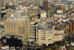
The Hill is also home to New Haven's main railroad station,
307:
The Hill neighborhood contains the majority of buildings of
209:, a 1.1 mile highway stub that was never extended toward
27:
Neighborhood of New Haven in
Connecticut, United States
609:
518:
492:
232:, all on the National Register of Historic Places.
131:
119:
107:
32:
429:
427:
466:
397:
395:
281:Redfield & West Streets Historic District
8:
334:Leadership Academy and the Wilson Library.
473:
459:
451:
29:
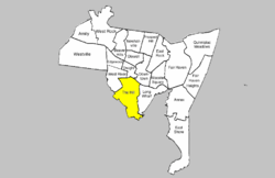
146:is the southwesternmost neighborhood of
653:Neighborhoods in New Haven, Connecticut
356:
106:
71:
59:
45:
259:neighborhood at the east, the city of
444:2010 census report for 06519 zip code
372:(Map). New Haven City Plan Department
130:
118:
67:location of The Hill within New Haven
7:
277:National Register of Historic Places
255:and Legion Ave. at the north, the
226:New Haven Jewish Home for the Aged
25:
324:Hill Regional Career High School
61:
47:
289:Howard Avenue Historic District
1:
347:3.6% from two or more races.
328:Betsy Ross Arts Magnet School
253:Route 34/Oak Street Connector
251:The Hill is bounded by the
669:
72:
60:
46:
41:Neighborhood of New Haven
39:
309:Yale-New Haven Hospital
222:Ahavas Sholem Synagogue
168:Yale School of Medicine
164:Yale-New Haven Hospital
160:New Haven Union Station
54:Yale-New Haven Hospital
304:
248:
194:
302:
243:
230:Welch Training School
189:
207:Oak Street Connector
200:Underground Railroad
192:Oak Street Connector
313:Yale Medical School
88: /
632:Fair Haven Heights
591:Quinnipiac Meadows
305:
249:
215:Downtown New Haven
195:
156:Downtown New Haven
640:
639:
418:"The Yale Herald"
416:Gibbons, Lauren.
269:Trowbridge Square
265:Long Island Sound
263:at the west, and
246:Trowbridge Square
228:, and the former
141:
140:
92:41.296°N 72.937°W
16:(Redirected from
660:
500:Amity-West Hills
475:
468:
461:
452:
445:
442:
436:
431:
422:
421:
413:
407:
406:
399:
390:
387:
381:
380:
378:
377:
371:
361:
332:Roberto Clemente
103:
102:
100:
99:
98:
93:
89:
86:
85:
84:
81:
65:
51:
30:
21:
18:Hill (New Haven)
668:
667:
663:
662:
661:
659:
658:
657:
643:
642:
641:
636:
605:
514:
488:
479:
449:
448:
443:
439:
434:Hello New Haven
432:
425:
415:
414:
410:
401:
400:
393:
388:
384:
375:
373:
369:
363:
362:
358:
353:
340:
297:
238:
176:
97:41.296; -72.937
96:
94:
90:
87:
82:
79:
77:
75:
74:
68:
56:
42:
35:
28:
23:
22:
15:
12:
11:
5:
666:
664:
656:
655:
645:
644:
638:
637:
635:
634:
629:
624:
619:
613:
611:
607:
606:
604:
603:
601:Wooster Square
598:
593:
588:
583:
578:
573:
568:
563:
558:
553:
548:
543:
538:
533:
528:
522:
520:
516:
515:
513:
512:
507:
502:
496:
494:
490:
489:
480:
478:
477:
470:
463:
455:
447:
446:
437:
423:
408:
391:
382:
355:
354:
352:
349:
339:
336:
296:
293:
237:
234:
181:Simeon Jocelyn
175:
172:
139:
138:
133:
129:
128:
123:
117:
116:
111:
105:
104:
70:
69:
66:
58:
57:
52:
44:
43:
40:
37:
36:
33:
26:
24:
14:
13:
10:
9:
6:
4:
3:
2:
665:
654:
651:
650:
648:
633:
630:
628:
625:
623:
620:
618:
615:
614:
612:
608:
602:
599:
597:
594:
592:
589:
587:
586:Prospect Hill
584:
582:
579:
577:
574:
572:
569:
567:
564:
562:
559:
557:
554:
552:
549:
547:
544:
542:
539:
537:
534:
532:
529:
527:
524:
523:
521:
517:
511:
508:
506:
503:
501:
498:
497:
495:
491:
487:
483:
482:Neighborhoods
476:
471:
469:
464:
462:
457:
456:
453:
441:
438:
435:
430:
428:
424:
419:
412:
409:
404:
398:
396:
392:
386:
383:
368:
367:
360:
357:
350:
348:
345:
337:
335:
333:
329:
325:
321:
320:Union Station
316:
314:
310:
301:
294:
292:
290:
284:
282:
278:
274:
270:
266:
262:
258:
254:
247:
244:Houses along
242:
235:
233:
231:
227:
223:
218:
216:
212:
208:
203:
201:
193:
188:
184:
182:
173:
171:
169:
165:
161:
157:
153:
149:
145:
137:
134:
127:
124:
122:
115:
114:United States
112:
110:
101:
73:Coordinates:
64:
55:
50:
38:
31:
19:
581:Newhallville
526:Beaver Hills
440:
411:
385:
374:. Retrieved
365:
359:
341:
338:Demographics
317:
306:
285:
250:
219:
204:
196:
177:
143:
142:
162:as well as
152:Connecticut
126:Connecticut
95: /
627:Fair Haven
622:East Shore
596:West River
576:Mill River
571:Long Wharf
536:City Point
531:Cedar Hill
376:2009-02-06
351:References
273:City Point
261:West Haven
257:Long Wharf
83:72°56′13″W
80:41°17′46″N
617:The Annex
556:East Rock
510:Westville
505:West Rock
486:New Haven
236:Geography
148:New Haven
136:New Haven
647:Category
566:The Hill
561:Edgewood
546:Downtown
344:ZIP code
166:and the
144:The Hill
34:The Hill
541:Dixwell
519:Central
295:Economy
174:History
109:Country
551:Dwight
271:, and
224:, the
370:(PDF)
211:Derby
121:State
610:East
493:West
366:Hill
342:The
311:and
132:City
484:of
649::
426:^
394:^
330:,
326:,
291:.
283:.
217:.
202:.
170:.
150:,
474:e
467:t
460:v
420:.
405:.
379:.
20:)
Text is available under the Creative Commons Attribution-ShareAlike License. Additional terms may apply.