311:, and represented a shift in the approach to mental illness in the region. Where previously those with mental illnesses were held at Lyttelton Gaol, the hospital was founded on the principles of moral management, providing a more supportive environment for patients. Commitment to this approach varied throughout the hospital's existence, until it was closed in 1999 due to replacement by the neighbouring Hillmorton Hospital. The final buildings of the former Sunnyside Hospital were demolished in April 2007 to make way for additional housing, a move which was met with protest due to the architectural and cultural significance of the structures. Hillmorton Hospital continues to act as a dedicated mental health facility for the city from nearby to the original Sunnyside location.
315:
47:
244:
251:
236:
229:
463:. There were 1,089 households, comprising 1,383 males and 1,455 females, giving a sex ratio of 0.95 males per female. The median age was 38.2 years (compared with 37.4 years nationally), with 483 people (17.0%) aged under 15 years, 570 (20.1%) aged 15 to 29, 1,323 (46.6%) aged 30 to 64, and 462 (16.3%) aged 65 or older.
511:
Of those at least 15 years old, 552 (23.4%) people had a bachelor's or higher degree, and 420 (17.8%) people had no formal qualifications. The median income was $ 35,300, compared with $ 31,800 nationally. 378 people (16.1%) earned over $ 70,000 compared to 17.2% nationally. The employment status of
330:
monastery to be established as the order's first New
Zealand presence. The monastery was originally founded in a pre-existing homestead in June 1933, with the first wing not being completed until four years later. This was followed by the addition of a subsequent wing in 1950, since which point the
302:
Hillmorton takes its name from Hill Morton Farm, the property of John
Twigger, who settled in the area in 1863. Land from the subdivision of this farm was advertised for sale in a local newspaper in 1879 as being "part of Twigger's property known as Hillmorton". At the same time as Twigger settled
523:
Southern
Regional Health School is a special school. It had a roll of 19 as of August 2024. It provides education for children throughout the South Island who are too ill to attend a regular school.
801:
319:
520:
Hillmorton High School is a secondary school catering for years 7 to 13. It had a roll of 1318 as of August 2024. The school opened in 1961 as Hoon Hay Post
Primary School.
388:
Hillmorton covers 2.92 km (1.13 sq mi). It had an estimated population of 2,930 as of June 2023, with a population density of 1,003 people per km.
67:
46:
985:
856:
119:
359:
South of
Halswell Road, except Coppell Place which is part of Hillmorton (properties on this section of Haslwell Road are part of Hillmorton)
286:, New Zealand. The suburb is centred around the intersection of Lincoln Road and Hoon hay Road, two arterial routes which form part of
512:
those at least 15 was that 1,260 (53.5%) people were employed full-time, 342 (14.5%) were part-time, and 63 (2.7%) were unemployed.
569:
1689:
1586:
148:
1576:
488:
Although some people chose not to answer the census's question about religious affiliation, 49.4% had no religion, 37.6% were
340:
1632:
1607:
378:
291:
287:
652:
623:
107:
540:
1612:
1476:
630:
489:
1561:
1501:
1451:
978:
887:
1658:
1627:
1284:
1244:
1173:
1122:
1011:
308:
124:
1637:
1536:
1506:
1345:
1052:
1042:
1037:
681:
753:
933:
909:
1622:
1516:
1511:
1466:
1234:
1198:
1163:
1097:
872:
505:
497:
475:
460:
456:
452:
1047:
597:
1668:
1566:
1416:
1390:
1370:
1350:
1304:
1294:
1289:
1279:
1274:
1224:
1183:
1168:
1148:
1102:
601:
374:
368:
343:
River flows along the northern boundary of
Hillmorton which along with Curletts Road is the boundary with
214:
209:
861:
1663:
1602:
1486:
1431:
1426:
1421:
1385:
1324:
1314:
1208:
1188:
1112:
1077:
1007:
971:
1127:
689:
1617:
1531:
1269:
1249:
1158:
1117:
1032:
501:
479:
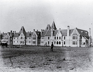
307:, Christchurch's first mental asylum. The buildings were constructed in a gothic style by architect
1521:
1481:
1360:
1153:
1082:
1067:
314:
1193:
1178:
304:
51:
727:
1571:
1365:
493:
1062:
701:
1446:
1526:
1319:
365:
South of
Lincoln Road (properties on this section of Lincoln Road are part of Hillmorton)
832:
471:
1203:
1092:
1683:
1461:
775:
994:
283:
112:
467:
485:
The percentage of people born overseas was 26.0, compared with 27.1% nationally.
998:
482:, and 3.2% other ethnicities. People may identify with more than one ethnicity.
353:
West of
Templetons Road. (properties on Templetons Road are part of Hillmorton)
1642:
1581:
1471:
1411:
350:
327:
264:
371:
West of
Wrights Road (properties on Wrights Road are not part of Hillmorton)
82:
69:
1496:
1456:
1436:
1395:
1254:
1057:
963:
1441:
1340:
1299:
1264:
1229:
1087:
1072:
362:
356:
271:
257:
1380:
1375:
1355:
1309:
1239:
1107:
405:
1541:
1143:
344:
221:
37:
331:
monastery has maintained their presence in the heart of
Hillmorton.
1491:
313:
780:
Carmelite Monastery of Christ the King Christchurch, New Zealand
967:
945:
592:
590:
400:
859:. Statistics New Zealand. March 2020. Hillmorton (325000).
882:
880:
680:
Blake-Palmer, Geoffrey. 1966. 'Hospitals, Mental', In
326:
In 1933, Hillmorton was also chosen as the site for a
1651:
1595:
1554:
1404:
1333:
1217:
1136:
1025:
1018:
192:
184:
179:
171:
166:
147:
130:
118:
106:
98:
28:
459:, and an increase of 678 people (31.4%) since the
347:. Hillmorton also borders several other suburbs:
934:Education Counts: Southern Regional Health School
946:"Kia Ora! Welcome to the Southern Health School"
827:
825:
823:
821:
54:, once the best-known institution of Hillmorton
851:
849:
979:
541:"Wards, Councillors and Community Boards map"
455:, an increase of 183 people (6.9%) since the
8:
910:"Miscellaneous Local Historical Information"
857:"Statistical area 1 dataset for 2018 Census"
451:Hillmorton had a population of 2,838 at the
391:
802:"2021-Community-Profiles-Spreydon-Ward.pdf"
303:the area, 1863 also saw the opening of the
1022:
986:
972:
964:
390:
203:
25:
915:. Christchurch City Libraries. p. 80
873:Education Counts: Hillmorton High School
532:
294:which runs to the north of the suburb.
178:
165:
97:
62:
58:
43:
598:"Population estimate tables - NZ.Stat"
564:
562:
862:2018 Census place summary: Hillmorton
191:
183:
170:
146:
129:
117:
105:
7:
708:. Underground Overground Archaeology
890:. New Zealand Ministry of Education
782:. Carmelite Monastery, Christchurch
159:Waihoro Spreydon-Cashmere-Heathcote
23:Suburb in Christchurch, New Zealand
16:Suburb of Christchurch, New Zealand
14:
948:. Southern Regional Health School
653:"Christchurch Place Names: A – M"
156:Waipuna Halswell-Hornby-Riccarton
732:my.christchurchcitylibraries.com
466:Ethnicities were 77.1% European/
322:Church, Hillmorton, Christchurch
249:
242:
234:
227:
45:
1587:Tauhinukorokio / Mount Pleasant
1567:Avon-Heathcote Estuary / Ihutai
888:"New Zealand Schools Directory"
686:An Encyclopaedia of New Zealand
377:to the North, separated by the
1633:International Antarctic Centre
624:"Christchurch Street Names: H"
508:and 2.5% had other religions.
379:Christchurch Southern Motorway
292:Christchurch Southern Motorway
1:
833:"Address and Postcode Finder"
734:. Christchurch City Libraries
662:. Christchurch City Libraries
660:christchurchcitylibraries.com
282:is a suburb of south-western
250:
228:
243:
235:
175:292 ha (722 acres)
1613:Christchurch Adventure Park
688:. (Accessed 19 August 2007)
631:Christchurch City Libraries
547:. Christchurch City Council
1706:
1596:Facilities and attractions
1577:Ōpāwaho / Heathcote River
1005:
444:
418:—
341:Heathcote River (Ōpāwaho)
125:Christchurch City Council
63:
59:
44:
35:
1638:Margaret Mahy Playground
570:"ArcGIS Web Application"
83:43.555231°S 172.591994°E
1690:Suburbs of Christchurch
1623:Ferrymead Regional Park
574:statsnz.maps.arcgis.com
494:Māori religious beliefs
453:2018 New Zealand census
706:Christchurch Uncovered
602:Statistics New Zealand
323:
88:-43.555231; 172.591994
1603:Akaroa Marine Reserve
754:"Hillmorton Hospital"
392:Historical population
317:
1618:Christchurch Gondola
1562:Avon River / Ōtākaro
1012:Christchurch Central
728:"Sunnyside Hospital"
1555:Geographic features
1482:Murray Aynsley Hill
700:Watson, Katharine.
393:
196:Hillmorton Hospital
79: /
1194:South New Brighton
1179:North New Brighton
756:. Hospital website
702:"Inside an asylum"
622:Harper, Margaret.
324:
305:Sunnyside Hospital
290:and feed into the
185: • Total
52:Sunnyside Hospital
1677:
1676:
1572:Lyttelton Harbour
1550:
1549:
449:
448:
277:
276:
200:
199:
172: • Land
1697:
1669:Regional Council
1608:Cathedral Square
1447:Heathcote Valley
1405:Southern suburbs
1026:Northern suburbs
1023:
1019:Populated places
988:
981:
974:
965:
958:
957:
955:
953:
942:
936:
931:
925:
924:
922:
920:
914:
906:
900:
899:
897:
895:
884:
875:
870:
864:
860:
853:
844:
843:
841:
839:
829:
816:
815:
813:
811:
806:
798:
792:
791:
789:
787:
772:
766:
765:
763:
761:
750:
744:
743:
741:
739:
724:
718:
717:
715:
713:
697:
691:
678:
672:
671:
669:
667:
657:
649:
643:
642:
640:
638:
628:
619:
613:
612:
610:
608:
594:
585:
584:
582:
580:
566:
557:
556:
554:
552:
537:
407:
402:
394:
288:State Highway 75
253:
252:
246:
245:
241:
238:
237:
231:
230:
204:
94:
93:
91:
90:
89:
84:
80:
77:
76:
75:
72:
49:
26:
1705:
1704:
1700:
1699:
1698:
1696:
1695:
1694:
1680:
1679:
1678:
1673:
1647:
1591:
1546:
1527:Taylors Mistake
1400:
1334:Western suburbs
1329:
1320:Upper Riccarton
1218:Central suburbs
1213:
1137:Eastern suburbs
1132:
1014:
1001:
992:
962:
961:
951:
949:
944:
943:
939:
932:
928:
918:
916:
912:
908:
907:
903:
893:
891:
886:
885:
878:
871:
867:
855:
854:
847:
837:
835:
831:
830:
819:
809:
807:
804:
800:
799:
795:
785:
783:
774:
773:
769:
759:
757:
752:
751:
747:
737:
735:
726:
725:
721:
711:
709:
699:
698:
694:
682:A. H. McLintock
679:
675:
665:
663:
655:
651:
650:
646:
636:
634:
626:
621:
620:
616:
606:
604:
596:
595:
588:
578:
576:
568:
567:
560:
550:
548:
539:
538:
534:
529:
518:
386:
337:
300:
254:
247:
239:
232:
202:
201:
162:
149:Community board
143:
120:Local authority
87:
85:
81:
78:
73:
70:
68:
66:
65:
55:
40:
31:
24:
17:
12:
11:
5:
1703:
1701:
1693:
1692:
1682:
1681:
1675:
1674:
1672:
1671:
1666:
1661:
1655:
1653:
1649:
1648:
1646:
1645:
1640:
1635:
1630:
1625:
1620:
1615:
1610:
1605:
1599:
1597:
1593:
1592:
1590:
1589:
1584:
1579:
1574:
1569:
1564:
1558:
1556:
1552:
1551:
1548:
1547:
1545:
1544:
1539:
1534:
1529:
1524:
1519:
1514:
1509:
1504:
1499:
1494:
1489:
1484:
1479:
1477:Mount Pleasant
1474:
1469:
1464:
1459:
1454:
1449:
1444:
1439:
1434:
1429:
1424:
1419:
1414:
1408:
1406:
1402:
1401:
1399:
1398:
1393:
1388:
1383:
1378:
1373:
1368:
1363:
1358:
1353:
1348:
1343:
1337:
1335:
1331:
1330:
1328:
1327:
1322:
1317:
1312:
1307:
1302:
1297:
1292:
1287:
1282:
1277:
1272:
1267:
1262:
1257:
1252:
1247:
1242:
1237:
1232:
1227:
1221:
1219:
1215:
1214:
1212:
1211:
1206:
1204:Waimairi Beach
1201:
1196:
1191:
1186:
1181:
1176:
1171:
1166:
1161:
1156:
1151:
1146:
1140:
1138:
1134:
1133:
1131:
1130:
1125:
1120:
1115:
1110:
1105:
1100:
1095:
1093:McLeans Island
1090:
1085:
1080:
1075:
1070:
1065:
1060:
1055:
1050:
1045:
1040:
1035:
1029:
1027:
1020:
1016:
1015:
1006:
1003:
1002:
993:
991:
990:
983:
976:
968:
960:
959:
937:
926:
901:
876:
865:
845:
817:
793:
767:
745:
719:
692:
673:
644:
614:
586:
558:
531:
530:
528:
525:
517:
514:
447:
446:
442:
441:
438:
435:
431:
430:
427:
424:
420:
419:
416:
413:
409:
408:
403:
398:
385:
382:
336:
333:
299:
296:
275:
274:
269:
267:
261:
260:
255:
248:
233:
226:
224:
218:
217:
212:
207:
198:
197:
194:
190:
189:
186:
182:
181:
177:
176:
173:
169:
168:
164:
163:
161:
160:
157:
153:
151:
145:
144:
142:
141:
138:
134:
132:
131:Electoral ward
128:
127:
122:
116:
115:
110:
104:
103:
100:
96:
95:
61:
60:
57:
56:
50:
42:
41:
36:
33:
32:
29:
22:
21:
20:
15:
13:
10:
9:
6:
4:
3:
2:
1702:
1691:
1688:
1687:
1685:
1670:
1667:
1665:
1662:
1660:
1657:
1656:
1654:
1650:
1644:
1641:
1639:
1636:
1634:
1631:
1629:
1626:
1624:
1621:
1619:
1616:
1614:
1611:
1609:
1606:
1604:
1601:
1600:
1598:
1594:
1588:
1585:
1583:
1580:
1578:
1575:
1573:
1570:
1568:
1565:
1563:
1560:
1559:
1557:
1553:
1543:
1540:
1538:
1535:
1533:
1530:
1528:
1525:
1523:
1520:
1518:
1515:
1513:
1510:
1508:
1505:
1503:
1502:Richmond Hill
1500:
1498:
1495:
1493:
1490:
1488:
1485:
1483:
1480:
1478:
1475:
1473:
1470:
1468:
1465:
1463:
1462:Kennedys Bush
1460:
1458:
1455:
1453:
1450:
1448:
1445:
1443:
1440:
1438:
1435:
1433:
1430:
1428:
1425:
1423:
1420:
1418:
1415:
1413:
1410:
1409:
1407:
1403:
1397:
1394:
1392:
1389:
1387:
1384:
1382:
1379:
1377:
1374:
1372:
1369:
1367:
1364:
1362:
1359:
1357:
1354:
1352:
1349:
1347:
1344:
1342:
1339:
1338:
1336:
1332:
1326:
1323:
1321:
1318:
1316:
1313:
1311:
1308:
1306:
1303:
1301:
1298:
1296:
1293:
1291:
1288:
1286:
1283:
1281:
1278:
1276:
1273:
1271:
1268:
1266:
1263:
1261:
1258:
1256:
1253:
1251:
1248:
1246:
1243:
1241:
1238:
1236:
1233:
1231:
1228:
1226:
1223:
1222:
1220:
1216:
1210:
1207:
1205:
1202:
1200:
1197:
1195:
1192:
1190:
1187:
1185:
1182:
1180:
1177:
1175:
1172:
1170:
1167:
1165:
1162:
1160:
1157:
1155:
1152:
1150:
1147:
1145:
1142:
1141:
1139:
1135:
1129:
1126:
1124:
1121:
1119:
1116:
1114:
1111:
1109:
1106:
1104:
1101:
1099:
1096:
1094:
1091:
1089:
1086:
1084:
1081:
1079:
1076:
1074:
1071:
1069:
1068:Coutts Island
1066:
1064:
1061:
1059:
1056:
1054:
1051:
1049:
1046:
1044:
1041:
1039:
1036:
1034:
1031:
1030:
1028:
1024:
1021:
1017:
1013:
1009:
1004:
1000:
996:
989:
984:
982:
977:
975:
970:
969:
966:
947:
941:
938:
935:
930:
927:
911:
905:
902:
889:
883:
881:
877:
874:
869:
866:
863:
858:
852:
850:
846:
834:
828:
826:
824:
822:
818:
803:
797:
794:
781:
777:
771:
768:
755:
749:
746:
733:
729:
723:
720:
707:
703:
696:
693:
690:
687:
683:
677:
674:
661:
654:
648:
645:
632:
625:
618:
615:
603:
599:
593:
591:
587:
575:
571:
565:
563:
559:
546:
542:
536:
533:
526:
524:
521:
515:
513:
509:
507:
503:
499:
495:
491:
486:
483:
481:
477:
473:
469:
464:
462:
458:
454:
443:
439:
436:
433:
432:
428:
425:
422:
421:
417:
414:
411:
410:
404:
399:
396:
395:
389:
383:
381:
380:
376:
372:
370:
366:
364:
360:
358:
354:
352:
348:
346:
342:
334:
332:
329:
321:
316:
312:
310:
309:John Campbell
306:
297:
295:
293:
289:
285:
281:
273:
270:
268:
266:
263:
262:
259:
256:
225:
223:
220:
219:
216:
213:
211:
208:
206:
205:
195:
187:
174:
158:
155:
154:
152:
150:
139:
136:
135:
133:
126:
123:
121:
114:
111:
109:
101:
92:
64:Coordinates:
53:
48:
39:
34:
27:
19:
1659:City Council
1452:Hillsborough
1285:Phillipstown
1259:
1245:Central City
1174:New Brighton
1123:Spencerville
995:Christchurch
952:24 September
950:. Retrieved
940:
929:
919:24 September
917:. Retrieved
904:
894:17 September
892:. Retrieved
868:
836:. Retrieved
808:. Retrieved
796:
784:. Retrieved
779:
770:
758:. Retrieved
748:
736:. Retrieved
731:
722:
710:. Retrieved
705:
695:
685:
676:
664:. Retrieved
659:
647:
635:. Retrieved
633:. p. 95
617:
605:. Retrieved
579:24 September
577:. Retrieved
573:
549:. Retrieved
544:
535:
522:
519:
510:
504:, 0.8% were
500:, 0.5% were
496:, 2.7% were
487:
484:
465:
450:
387:
384:Demographics
373:
367:
361:
355:
349:
338:
325:
318:St Martin's
301:
284:Christchurch
279:
278:
113:Christchurch
18:
1628:Hagley Park
1537:Westmorland
1507:Scarborough
1043:Bottle Lake
999:New Zealand
545:ccc.govt.nz
492:, 0.5% had
461:2006 census
457:2013 census
102:New Zealand
86: /
74:172°35′31″E
1652:Government
1582:Port Hills
1517:St Martins
1512:Somerfield
1472:Moncks Bay
1412:Aidanfield
1346:Broomfield
1260:Hillmorton
1235:Barrington
1199:Southshore
1164:Dallington
1053:Brooklands
1038:Bishopdale
607:25 October
527:References
351:Aidanfield
280:Hillmorton
265:Aidanfield
240:Hillmorton
180:Population
71:43°33′19″S
30:Hillmorton
1497:Redcliffs
1467:Lansdowne
1457:Huntsbury
1437:Ferrymead
1417:Beckenham
1396:Yaldhurst
1391:Templeton
1371:Islington
1305:St Albans
1290:Riccarton
1280:Middleton
1255:Fendalton
1225:Addington
1184:Parklands
1169:Marshland
1103:Northwood
1098:Northcote
1058:Casebrook
786:23 August
776:"History"
738:23 August
712:23 August
666:23 August
551:14 August
516:Education
490:Christian
375:Middleton
369:Addington
335:Geography
328:Carmelite
215:Addington
210:Middleton
193:Hospitals
1684:Category
1487:Oaklands
1442:Halswell
1432:Cracroft
1422:Cashmere
1386:Sockburn
1351:Burnside
1341:Avonhead
1325:Woolston
1315:Sydenham
1300:Spreydon
1295:Richmond
1275:Merivale
1265:Hoon Hay
1230:Avonside
1189:Prestons
1149:Avondale
1088:Mairehau
1078:Harewood
1073:Edgeware
1048:Bridgend
506:Buddhist
478:, 16.3%
476:Pasifika
445:Source:
363:Spreydon
357:Hoon Hay
320:Anglican
272:Hoon Hay
258:Spreydon
140:Spreydon
137:Halswell
1643:Tūranga
1532:Waltham
1427:Clifton
1381:Russley
1376:Paparua
1356:Hei Hei
1310:Strowan
1270:Linwood
1250:Bromley
1240:Bryndwr
1209:Wainoni
1159:Burwood
1118:Shirley
1113:Redwood
1108:Papanui
1063:Chaneys
1033:Belfast
838:16 June
810:16 June
684:, ed.,
474:, 3.8%
470:, 8.9%
406:±% p.a.
298:History
99:Country
1542:Wigram
1522:Sumner
1361:Hornby
1154:Bexley
1144:Aranui
1083:Kainga
760:30 May
637:31 May
502:Muslim
468:Pākehā
440:+1.34%
429:+2.99%
345:Wigram
222:Wigram
38:Suburb
1664:Mayor
1492:Opawa
913:(PDF)
805:(PDF)
656:(PDF)
627:(PDF)
498:Hindu
480:Asian
472:Māori
437:2,838
426:2,655
415:2,160
188:2,930
1366:Ilam
1128:Styx
1008:Seat
954:2021
921:2021
896:2024
840:2021
812:2021
788:2020
762:2020
740:2020
714:2020
668:2020
639:2020
609:2023
581:2021
553:2020
434:2018
423:2013
412:2006
401:Pop.
397:Year
339:The
167:Area
108:City
1686::
1010::
997:,
879:^
848:^
820:^
778:.
730:.
704:.
658:.
629:.
600:.
589:^
572:.
561:^
543:.
987:e
980:t
973:v
956:.
923:.
898:.
842:.
814:.
790:.
764:.
742:.
716:.
670:.
641:.
611:.
583:.
555:.
Text is available under the Creative Commons Attribution-ShareAlike License. Additional terms may apply.