40:
636:
84:
153:
55:
65:
91:
368:. The area was colonized by German settlers in the second half of the 13th century. The coexistence of Czechs and Germans was mostly peaceful, which changed only after 1935, when many Germans tended to Nazism. In 1945, the German population was
746:
643:
Hlubočany is poor in monuments. The only protected cultural monument is a rural house from the second half of the 19th century, which is evidence of the specific mud houses typical of this region.
768:
39:
707:
827:
646:
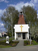
In the centre of Hlubočany is the Chapel of Saint
Florian. It was built in 1935 on the site of an older Baroque chapel. A small chapel is also in Terešov.
369:
1281:
1007:
83:
1260:
1184:
1255:
1233:
1107:
1002:
898:
888:
115:
1162:
982:
883:
820:
1157:
177:
1228:
1223:
1112:
1047:
1012:
948:
913:
1206:
1057:
933:
903:
165:
987:
269:
813:
64:
54:
938:
754:
732:
667:
1238:
1062:
635:
1167:
1152:
854:
318:
248:
170:
663:
805:
1142:
961:
943:
350:
258:
859:
728:
972:
843:
314:
182:
1127:
306:
1212:
1102:
893:
1195:
1147:
1067:
1027:
992:
322:
158:
1275:
1243:
1052:
1072:
997:
967:
954:
364:
Until 1945, Hlubočany and Terešov belonged to the German-speaking enclave called
1201:
1189:
1173:
1077:
928:
918:
877:
864:
1179:
1042:
1017:
977:
870:
130:
117:
239:
1249:
1137:
838:
342:
1218:
1132:
1117:
1097:
1092:
1087:
1082:
1037:
1032:
1022:
908:
627:
There are no railways or major roads passing through the municipality.
353:. The highest point is at 355 m (1,165 ft) above sea level.
1122:
265:
244:
708:"S památníkem německým starousedlíkům si Vyškov zatím neví rady"
550:
474:
398:
346:
30:
809:
333:
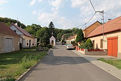
The village of Terešov is an administrative part of Hlubočany.
341:
Hlubočany is located about 5 kilometres (3 mi) south of
545:
469:
393:
798:
769:"Výsledky vyhledávání: Kulturní památky, obec Hlubočany"
686:
291:
372:
and the municipality was resettled by Czech families.
361:
The first written mention of Hlubočany is from 1141.
729:"Historický lexikon obcí České republiky 1869–2011"
286:
276:
255:
238:
230:
222:
217:
209:
201:
196:
188:
176:
164:
146:
21:
664:"Population of Municipalities – 1 January 2024"
349:. It lies in an agricultural landscape in the
16:Municipality in South Moravian, Czech Republic
821:
8:
380:
747:"Population Census 2021: Population by sex"
828:
814:
806:
379:
18:
681:
679:
677:
634:
775:(in Czech). National Heritage Institute
655:
285:
275:
237:
216:
208:
195:
187:
145:
110:
76:
48:
36:
254:
229:
221:
200:
175:
163:
7:
345:and 26 km (16 mi) east of
313:) is a municipality and village in
205:8.06 km (3.11 sq mi)
773:Ústřední seznam kulturních památek
14:
90:
710:(in Czech). iDNES.cz. 2012-03-05
325:. It has about 500 inhabitants.
151:
89:
82:
63:
53:
38:
103:Location in the Czech Republic
1:
44:Terešov, a part of Hlubočany
1282:Villages in Vyškov District
1298:
689:(in Czech). Obec Hlubočany
384:
850:
615:
411:—
111:
77:
49:
37:
28:
755:Czech Statistical Office
733:Czech Statistical Office
668:Czech Statistical Office
213:273 m (896 ft)
639:Chapel of Saint Florian
640:
366:Vyškov Language Island
310:
234:67/km (170/sq mi)
1013:Křižanovice u Vyškova
638:
381:Historical population
319:South Moravian Region
257: • Summer (
131:49.23056°N 17.00028°E
329:Administrative parts
231: • Density
1168:Rostěnice-Zvonovice
860:Bohdalice-Pavlovice
382:
127: /
1239:Vážany nad Litavou
1063:Moravské Málkovice
641:
223: • Total
202: • Total
136:49.23056; 17.00028
1269:
1268:
962:Ivanovice na Hané
944:Hoštice-Heroltice
620:
619:
611:
610:
535:
534:
459:
458:
300:
299:
1289:
1153:Račice-Pístovice
939:Hostěrádky-Rešov
855:Bohaté Málkovice
842:and villages of
830:
823:
816:
807:
802:
801:
799:Official website
784:
783:
781:
780:
765:
759:
758:
743:
737:
736:
725:
719:
718:
716:
715:
704:
698:
697:
695:
694:
683:
672:
671:
660:
616:Source: Censuses
552:
547:
539:
538:
476:
471:
463:
462:
400:
395:
387:
386:
383:
296:
293:
262:
157:
155:
154:
142:
141:
139:
138:
137:
132:
128:
125:
124:
123:
120:
93:
92:
86:
67:
57:
42:
19:
1297:
1296:
1292:
1291:
1290:
1288:
1287:
1286:
1272:
1271:
1270:
1265:
973:Kobeřice u Brna
846:
844:Vyškov District
834:
797:
796:
793:
788:
787:
778:
776:
767:
766:
762:
751:Public Database
745:
744:
740:
727:
726:
722:
713:
711:
706:
705:
701:
692:
690:
685:
684:
675:
662:
661:
657:
652:
633:
625:
378:
359:
351:Litenčice Hills
339:
331:
315:Vyškov District
290:
282:
256:
189:First mentioned
152:
150:
135:
133:
129:
126:
121:
118:
116:
114:
113:
107:
106:
105:
104:
101:
100:
99:
98:
94:
73:
72:
71:
70:
61:
60:
45:
33:
24:
17:
12:
11:
5:
1295:
1293:
1285:
1284:
1274:
1273:
1267:
1266:
1264:
1263:
1258:
1253:
1246:
1241:
1236:
1231:
1226:
1221:
1216:
1209:
1204:
1199:
1196:Slavkov u Brna
1192:
1187:
1182:
1177:
1170:
1165:
1160:
1155:
1150:
1145:
1143:Prusy-Boškůvky
1140:
1135:
1130:
1125:
1120:
1115:
1110:
1105:
1100:
1095:
1090:
1085:
1080:
1075:
1070:
1065:
1060:
1055:
1050:
1045:
1040:
1035:
1030:
1025:
1020:
1015:
1010:
1005:
1000:
995:
990:
985:
980:
975:
970:
965:
958:
951:
946:
941:
936:
931:
926:
921:
916:
911:
906:
901:
896:
891:
886:
881:
874:
867:
862:
857:
851:
848:
847:
835:
833:
832:
825:
818:
810:
804:
803:
792:
791:External links
789:
786:
785:
760:
738:
720:
699:
673:
654:
653:
651:
648:
632:
629:
624:
621:
618:
617:
613:
612:
609:
608:
605:
602:
598:
597:
594:
591:
587:
586:
583:
580:
576:
575:
572:
569:
565:
564:
561:
558:
554:
553:
548:
543:
536:
533:
532:
529:
526:
522:
521:
518:
515:
511:
510:
507:
504:
500:
499:
496:
493:
489:
488:
485:
482:
478:
477:
472:
467:
460:
457:
456:
453:
450:
446:
445:
442:
439:
435:
434:
431:
428:
424:
423:
420:
417:
413:
412:
409:
406:
402:
401:
396:
391:
377:
374:
358:
355:
338:
335:
330:
327:
323:Czech Republic
298:
297:
288:
284:
283:
280:
278:
274:
273:
263:
253:
252:
242:
236:
235:
232:
228:
227:
224:
220:
219:
215:
214:
211:
207:
206:
203:
199:
198:
194:
193:
190:
186:
185:
180:
174:
173:
171:South Moravian
168:
162:
161:
159:Czech Republic
148:
144:
143:
109:
108:
102:
96:
95:
88:
87:
81:
80:
79:
78:
75:
74:
68:
62:
58:
52:
51:
50:
47:
46:
43:
35:
34:
29:
26:
25:
22:
15:
13:
10:
9:
6:
4:
3:
2:
1294:
1283:
1280:
1279:
1277:
1262:
1259:
1257:
1254:
1252:
1251:
1247:
1245:
1242:
1240:
1237:
1235:
1232:
1230:
1227:
1225:
1222:
1220:
1217:
1215:
1214:
1210:
1208:
1205:
1203:
1200:
1198:
1197:
1193:
1191:
1188:
1186:
1183:
1181:
1178:
1176:
1175:
1171:
1169:
1166:
1164:
1161:
1159:
1156:
1154:
1151:
1149:
1146:
1144:
1141:
1139:
1136:
1134:
1131:
1129:
1126:
1124:
1121:
1119:
1116:
1114:
1111:
1109:
1106:
1104:
1101:
1099:
1096:
1094:
1091:
1089:
1086:
1084:
1081:
1079:
1076:
1074:
1071:
1069:
1066:
1064:
1061:
1059:
1056:
1054:
1051:
1049:
1046:
1044:
1041:
1039:
1036:
1034:
1031:
1029:
1026:
1024:
1021:
1019:
1016:
1014:
1011:
1009:
1006:
1004:
1001:
999:
996:
994:
991:
989:
986:
984:
981:
979:
976:
974:
971:
969:
966:
964:
963:
959:
957:
956:
952:
950:
947:
945:
942:
940:
937:
935:
932:
930:
927:
925:
922:
920:
917:
915:
912:
910:
907:
905:
902:
900:
897:
895:
892:
890:
887:
885:
882:
880:
879:
875:
873:
872:
868:
866:
863:
861:
858:
856:
853:
852:
849:
845:
841:
840:
831:
826:
824:
819:
817:
812:
811:
808:
800:
795:
794:
790:
774:
770:
764:
761:
757:. 2021-03-27.
756:
752:
748:
742:
739:
735:. 2015-12-21.
734:
730:
724:
721:
709:
703:
700:
688:
682:
680:
678:
674:
670:. 2024-05-17.
669:
665:
659:
656:
649:
647:
644:
637:
630:
628:
622:
614:
606:
603:
600:
599:
595:
592:
589:
588:
584:
581:
578:
577:
573:
570:
567:
566:
562:
559:
556:
555:
549:
544:
541:
540:
537:
530:
527:
524:
523:
519:
516:
513:
512:
508:
505:
502:
501:
497:
494:
491:
490:
486:
483:
480:
479:
473:
468:
465:
464:
461:
454:
451:
448:
447:
443:
440:
437:
436:
432:
429:
426:
425:
421:
418:
415:
414:
410:
407:
404:
403:
397:
392:
389:
388:
385:
375:
373:
371:
367:
362:
356:
354:
352:
348:
344:
336:
334:
328:
326:
324:
320:
316:
312:
308:
304:
295:
289:
279:
271:
267:
264:
260:
250:
246:
243:
241:
233:
225:
212:
204:
191:
184:
181:
179:
172:
169:
167:
160:
149:
140:
112:Coordinates:
85:
66:
56:
41:
32:
27:
20:
1248:
1211:
1194:
1172:
960:
953:
923:
894:Dobročkovice
876:
869:
839:market towns
837:
777:. Retrieved
772:
763:
750:
741:
731:(in Czech).
723:
712:. Retrieved
702:
691:. Retrieved
658:
645:
642:
626:
376:Demographics
365:
363:
360:
340:
332:
302:
301:
69:Coat of arms
31:Municipality
1261:Zelená Hora
1078:Nemochovice
1008:Křižanovice
884:Chvalkovice
277:Postal code
134: /
1244:Velešovice
1180:Ruprechtov
1158:Radslavice
1128:Podbřežice
1053:Milešovice
871:Brankovice
779:2024-08-26
714:2022-01-12
693:2024-04-11
650:References
311:Hobitschau
218:Population
119:49°13′50″N
1213:Švábenice
1108:Nové Sady
1103:Nížkovice
1048:Medlovice
1003:Křenovice
998:Krásensko
968:Ježkovice
955:Hvězdlice
924:Hlubočany
914:Habrovany
899:Dražovice
889:Dětkovice
687:"Vítejte"
623:Transport
337:Geography
303:Hlubočany
292:hlubocany
240:Time zone
210:Elevation
97:Hlubočany
23:Hlubočany
1276:Category
1219:Topolany
1207:Studnice
1202:Snovídky
1190:Šaratice
1185:Rybníček
1174:Rousínov
1163:Rašovice
1148:Pustiměř
1133:Podivice
1118:Orlovice
1098:Nevojice
1093:Nesovice
1088:Nemotice
1083:Nemojany
1068:Mouřínov
1058:Milonice
1038:Lysovice
1028:Lovčičky
1023:Letonice
993:Kožušice
983:Komořany
934:Holubice
929:Hodějice
919:Heršpice
904:Drnovice
878:Bučovice
865:Bošovice
370:expelled
178:District
122:17°0′1″E
1073:Němčany
1043:Malínky
1018:Kučerov
988:Kozlany
978:Kojátky
909:Drysice
836:Towns,
357:History
321:of the
317:in the
287:Website
147:Country
1256:Zbýšov
1250:Vyškov
1234:Vážany
1229:Uhřice
1224:Tučapy
1138:Podomí
1123:Otnice
1113:Olšany
949:Hrušky
631:Sights
574:−12.4%
563:−10.9%
509:−13.6%
455:+10.3%
444:+10.9%
343:Vyškov
307:German
281:682 01
183:Vyškov
166:Region
156:
1033:Luleč
607:+0.4%
596:+2.9%
585:−2.7%
531:−9.0%
520:+6.5%
498:+0.3%
487:−3.5%
433:+5.3%
422:+4.7%
266:UTC+2
245:UTC+1
601:2021
590:2011
579:2001
568:1991
557:1980
546:Pop.
542:Year
525:1970
514:1961
503:1950
492:1930
481:1921
470:Pop.
466:Year
449:1910
438:1900
427:1890
416:1880
405:1869
394:Pop.
390:Year
347:Brno
270:CEST
197:Area
192:1141
59:Flag
604:492
593:490
582:476
571:489
560:558
528:626
517:688
506:646
495:748
484:746
452:773
441:701
430:632
419:600
408:573
294:.cz
259:DST
249:CET
226:542
1278::
771:.
753:.
749:.
676:^
666:.
551:±%
475:±%
399:±%
309::
829:e
822:t
815:v
782:.
717:.
696:.
305:(
272:)
268:(
261:)
251:)
247:(
Text is available under the Creative Commons Attribution-ShareAlike License. Additional terms may apply.