213:
220:
25:
131:
347:
212:
290:
Originally the mountain which is visible today lay 200 metres below the surface. When the region was uplifted the outer layers were carried away leaving the hard
169:
352:
320:
357:
108:
46:
89:
162:
61:
42:
68:
297:
The slopes of the
Hochkelberg are covered today with dense beech woods with a variety of species. The ruins of
75:
35:
321:
Map service of the
Landscape Information System of the Rhineland-Palatinate Nature Conservation Office (
57:
342:
284:
276:
232:
82:
248:
336:
272:
298:
268:
136:
24:
184:
171:
291:
130:
236:
149:
255:
280:
18:
316:
314:
247:
200:
161:
148:
143:
123:
49:. Unsourced material may be challenged and removed.
8:
348:Mountains and hills of Rhineland-Palatinate
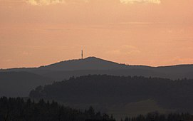
283:. Below the summit of the Hochkelberg is a
267:is one of the ten highest mountains in the
120:
275:, at the southern foot of which lies the
109:Learn how and when to remove this message
16:Mountain in Rhineland-Palatinate, Germany
135:The summit of the Hochkelberg seen from
310:
323:Naturschutzverwaltung Rheinland-Pfalz
7:
263:At 674.9 metres (2,214 ft) the
47:adding citations to reliable sources
219:
14:
301:buildings may also be seen here.
353:Mountains and hills of the Eifel
218:
211:
129:
23:
279:, an explosion crater lake or
34:needs additional citations for
1:
358:Mountains under 1000 metres
271:in Germany. It is a former
374:
205:
128:
185:50.272689°N 6.952707°E
43:improve this article
190:50.272689; 6.952707
181: /
285:transmission tower
144:Highest point
277:Mosbrucher Weiher
261:
260:
119:
118:
111:
93:
365:
327:
318:
251:
222:
221:
215:
196:
195:
193:
192:
191:
186:
182:
179:
178:
177:
174:
156:
133:
121:
114:
107:
103:
100:
94:
92:
51:
27:
19:
373:
372:
368:
367:
366:
364:
363:
362:
333:
332:
331:
330:
319:
312:
307:
249:
243:
242:
241:
240:
239:
233:Rheinland-Pfalz
230:
229:
228:
227:
223:
189:
187:
183:
180:
175:
172:
170:
168:
167:
157:(2,214 ft)
154:
139:
115:
104:
98:
95:
52:
50:
40:
28:
17:
12:
11:
5:
371:
369:
361:
360:
355:
350:
345:
335:
334:
329:
328:
309:
308:
306:
303:
259:
258:
253:
245:
244:
231:
225:
224:
217:
216:
210:
209:
208:
207:
206:
203:
202:
198:
197:
165:
159:
158:
152:
146:
145:
141:
140:
134:
126:
125:
117:
116:
99:September 2024
31:
29:
22:
15:
13:
10:
9:
6:
4:
3:
2:
370:
359:
356:
354:
351:
349:
346:
344:
341:
340:
338:
326:
324:
317:
315:
311:
304:
302:
300:
295:
293:
288:
286:
282:
278:
274:
273:stratovolcano
270:
266:
257:
254:
252:
246:
238:
234:
214:
204:
199:
194:
166:
164:
160:
153:
151:
147:
142:
138:
132:
127:
122:
113:
110:
102:
91:
88:
84:
81:
77:
74:
70:
67:
63:
60: –
59:
58:"Hochkelberg"
55:
54:Find sources:
48:
44:
38:
37:
32:This article
30:
26:
21:
20:
322:
296:
289:
269:Vulkan Eifel
264:
262:
250:Parent range
155:674.9 m
105:
96:
86:
79:
72:
65:
53:
41:Please help
36:verification
33:
343:Vulkaneifel
265:Hochkelberg
226:Hochkelberg
188: /
163:Coordinates
124:Hochkelberg
337:Categories
305:References
173:50°16′22″N
69:newspapers
201:Geography
176:6°57′10″E
150:Elevation
137:Gänsehals
292:basaltic
237:Germany
83:scholar
294:core.
85:
78:
71:
64:
56:
299:Roman
256:Eifel
90:JSTOR
76:books
281:maar
62:news
45:by
339::
313:^
287:.
235:,
325:)
112:)
106:(
101:)
97:(
87:·
80:·
73:·
66:·
39:.
Text is available under the Creative Commons Attribution-ShareAlike License. Additional terms may apply.