367:
971:
165:
172:
381:
29:
894:
337:
395:
325:
888:
353:
294:
known as the Tipton Till Plain. As a result, while the average elevation of this upland region is 1100±100 feet above sea level, the topographic relief is gentle where the "hill" is no more than 30 feet higher than the surrounding landscape of gently rolling farmland. While the high topography seen
317:
255:
digital elevation data which is now considered to be outdated. Using newer elevation tools such as USGS's 3DEP, the top of
Hoosier Hill is closer to 1,255.48 feet (382.67 meters) above sea level. Hoosier Hill is in the rural area of
313:
According to the local government, the wooden sign with the words, "INDIANA'S HIGHEST POINT" would frequently be stolen, so in 2016 the wooden sign was permanently replaced by an engraved boulder.
607:
303:
in south central
Indiana, can be mistaken to be a high point (where relief is 400–500 feet from valley to hilltop), the elevations of hilltops ranges from 800 to 1050 feet.
1012:
616:
283:
candidate named Kyle
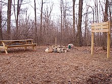
Cummings (Troop 820 from Lakeside Park, Kentucky), in cooperation with the property owner, built a trail, sign and picnic area at the high point.
84:
953:
1036:
286:
Geologically, the hill sits in the
Dearborn Upland, an area of high terrain in southeast Indiana that sits on top of the geologic structure known as the
1046:
257:
600:
1041:
164:
1005:
280:
279:
Hoosier Hill sits on private property owned by Kim E. Goble. The high point sits in a forested area surrounded by farmland. In 2005, an
593:
423:
413:
920:
449:
418:
307:
252:
69:
998:
218:
265:
77:
532:
817:
797:
742:
585:
251:
with a claimed elevation of 1,257 feet (383 meters) above sea level. Hoosier Hill's claimed elevation is based on
1031:
782:
712:
507:
268:. The nearest intersection to the high point is Elliot Road and County Line Road. The nearest major landmark is
970:
777:
296:
767:
757:
54:
978:
807:
261:
197:
802:
386:
372:
827:
752:
533:"First to climb 48 state high points, Arthur H. Marshall blazed a path that few choose to follow"
408:
64:
847:
717:
273:
982:
902:
772:
747:
358:
126:
571:
893:
852:
707:
667:
632:
429:
287:
213:
28:
316:
948:
943:
910:
842:
832:
792:
762:
732:
722:
677:
662:
647:
642:
553:
400:
291:
336:
1025:
928:
862:
822:
702:
692:
652:
300:
269:
206:
933:
877:
857:
672:
657:
231:
867:
787:
737:
290:. However, Hoosier Hill is located in a portion of the upland buried underneath
485:
461:
872:
812:
727:
687:
624:
348:
99:
86:
682:
324:
938:
248:
201:
511:
33:
The "summit" of
Hoosier Hill, the highest point in Indiana, June 2018.
837:
637:
44:
887:
335:
329:
323:
315:
310:. He completed the task in 1936 after standing atop Hoosier Hill.
617:
Highest natural points of U.S. states, district, and territories
589:
508:"Kyle Cummings Eagle Project Transforms Indiana's Hoosier Hill"
340:
Hoosier Hill, Indiana. The "summit" is in the grove. June 2018
306:
A.H. Marshall was the first person to successfully climb each
141:
138:
135:
986:
320:
Visitors at
Hoosier Hill, the highest point in Indiana
919:
901:
623:
230:
225:
212:
193:
152:
132:
129:
120:
115:
76:
63:
53:
43:
38:
21:
247:is the highest natural point in the U.S. state of
16:Highest natural point in the U.S. state of Indiana
1006:
601:
8:
1013:
999:
608:
594:
586:
18:
442:
426:, Indiana's second highest named point
486:"Pinnacle of Indiana in Wayne County"
432:, Indiana's third highest named point
7:
967:
965:
276:11 miles (18 km) to the south.
171:
1037:Landforms of Wayne County, Indiana
985:. You can help Knowledge (XXG) by
510:. HighPointers.org. Archived from
332:in the center marks the highpoint.
14:
554:"Example of stolen/replaced sign"
414:Index of Indiana-related articles
969:
892:
886:
419:List of U.S. states by elevation
393:
379:
365:
351:
170:
163:
125:
27:
1047:Central Indiana geography stubs
1:
1042:Highest points of U.S. states
949:U.S. Minor Outlying Islands
574:. Indiana Geological Survey
1063:
964:
49:1,257 ft (383 m)
884:
157:
100:40.0012194°N 84.8486889°W
26:
939:Northern Mariana Islands
572:"Landscapes of Indiana"
462:"Hoosier Hill, Indiana"
297:Brown County State Park
105:40.0012194; -84.8486889
59:297 ft (91 m)
981:location article is a
341:
333:
321:
979:Wayne County, Indiana
339:
327:
319:
70:U.S. state high point
911:District of Columbia
387:United States portal
373:North America portal
308:U.S. state highpoint
299:, which sits in the
264:to the northwest of
954:U.S. Virgin Islands
96: /
409:Outline of Indiana
342:
334:
322:
39:Highest point
994:
993:
962:
961:
258:Franklin Township
242:
241:
1054:
1032:Hills of Indiana
1015:
1008:
1001:
973:
966:
896:
890:
610:
603:
596:
587:
582:
580:
579:
558:
557:
550:
544:
543:
541:
540:
529:
523:
522:
520:
519:
504:
498:
497:
495:
493:
482:
476:
475:
473:
472:
458:
452:
447:
403:
398:
397:
396:
389:
384:
383:
382:
375:
370:
369:
368:
361:
359:Geography portal
356:
355:
354:
234:
174:
173:
167:
148:
147:
144:
143:
140:
137:
134:
131:
111:
110:
108:
107:
106:
101:
97:
94:
93:
92:
89:
31:
19:
1062:
1061:
1057:
1056:
1055:
1053:
1052:
1051:
1022:
1021:
1020:
1019:
963:
958:
915:
897:
891:
882:
619:
614:
577:
575:
570:
567:
562:
561:
552:
551:
547:
538:
536:
531:
530:
526:
517:
515:
506:
505:
501:
491:
489:
484:
483:
479:
470:
468:
460:
459:
455:
448:
444:
439:
430:Weed Patch Hill
399:
394:
392:
385:
380:
378:
371:
366:
364:
357:
352:
350:
347:
288:Cincinnati Arch
232:
205:
189:
188:
187:
186:
185:
182:
181:
180:
179:
175:
128:
124:
104:
102:
98:
95:
90:
87:
85:
83:
82:
34:
17:
12:
11:
5:
1060:
1058:
1050:
1049:
1044:
1039:
1034:
1024:
1023:
1018:
1017:
1010:
1003:
995:
992:
991:
974:
960:
959:
957:
956:
951:
946:
941:
936:
931:
929:American Samoa
925:
923:
917:
916:
914:
913:
907:
905:
899:
898:
885:
883:
881:
880:
875:
870:
865:
860:
855:
850:
845:
840:
835:
830:
828:South Carolina
825:
820:
815:
810:
805:
800:
795:
793:North Carolina
790:
785:
780:
775:
770:
765:
760:
755:
750:
745:
740:
735:
730:
725:
720:
715:
710:
705:
700:
695:
690:
685:
680:
675:
670:
665:
660:
655:
650:
645:
640:
635:
629:
627:
621:
620:
615:
613:
612:
605:
598:
590:
584:
583:
566:
565:External links
563:
560:
559:
545:
524:
499:
477:
466:Peakbagger.com
453:
441:
440:
438:
435:
434:
433:
427:
421:
416:
411:
405:
404:
401:Indiana portal
390:
376:
362:
346:
343:
292:glacial debris
240:
239:
236:
228:
227:
223:
222:
216:
210:
209:
195:
191:
190:
183:
177:
176:
169:
168:
162:
161:
160:
159:
158:
155:
154:
150:
149:
122:
118:
117:
113:
112:
80:
74:
73:
67:
61:
60:
57:
51:
50:
47:
41:
40:
36:
35:
32:
24:
23:
15:
13:
10:
9:
6:
4:
3:
2:
1059:
1048:
1045:
1043:
1040:
1038:
1035:
1033:
1030:
1029:
1027:
1016:
1011:
1009:
1004:
1002:
997:
996:
990:
988:
984:
980:
975:
972:
968:
955:
952:
950:
947:
945:
942:
940:
937:
935:
932:
930:
927:
926:
924:
922:
918:
912:
909:
908:
906:
904:
900:
895:
889:
879:
876:
874:
871:
869:
868:West Virginia
866:
864:
861:
859:
856:
854:
851:
849:
846:
844:
841:
839:
836:
834:
831:
829:
826:
824:
821:
819:
816:
814:
811:
809:
806:
804:
801:
799:
796:
794:
791:
789:
786:
784:
781:
779:
776:
774:
773:New Hampshire
771:
769:
766:
764:
761:
759:
756:
754:
751:
749:
746:
744:
741:
739:
736:
734:
733:Massachusetts
731:
729:
726:
724:
721:
719:
716:
714:
711:
709:
706:
704:
701:
699:
696:
694:
691:
689:
686:
684:
681:
679:
676:
674:
671:
669:
666:
664:
661:
659:
656:
654:
651:
649:
646:
644:
641:
639:
636:
634:
631:
630:
628:
626:
622:
618:
611:
606:
604:
599:
597:
592:
591:
588:
573:
569:
568:
564:
555:
549:
546:
535:. Oregon Live
534:
528:
525:
514:on 2010-11-02
513:
509:
503:
500:
487:
481:
478:
467:
463:
457:
454:
451:
446:
443:
436:
431:
428:
425:
422:
420:
417:
415:
412:
410:
407:
406:
402:
391:
388:
377:
374:
363:
360:
349:
344:
338:
331:
326:
318:
314:
311:
309:
304:
302:
301:Norman Upland
298:
293:
289:
284:
282:
277:
275:
271:
270:Interstate 70
267:
263:
259:
254:
250:
246:
237:
235:
233:Easiest route
229:
224:
220:
217:
215:
211:
208:
207:United States
203:
199:
196:
192:
166:
156:
151:
146:
123:
121:Pronunciation
119:
114:
109:
91:84°50′55.28″W
81:
79:
75:
71:
68:
66:
62:
58:
56:
52:
48:
46:
42:
37:
30:
25:
20:
987:expanding it
976:
833:South Dakota
823:Rhode Island
818:Pennsylvania
798:North Dakota
697:
576:. Retrieved
548:
537:. Retrieved
527:
516:. Retrieved
512:the original
502:
490:. Retrieved
480:
469:. Retrieved
465:
456:
445:
312:
305:
285:
278:
262:Wayne County
245:Hoosier Hill
244:
243:
198:Wayne County
178:Hoosier Hill
88:40°0′04.39″N
22:Hoosier Hill
944:Puerto Rico
921:Territories
748:Mississippi
663:Connecticut
281:Eagle Scout
221:Spartanburg
103: /
78:Coordinates
1026:Categories
863:Washington
783:New Mexico
778:New Jersey
653:California
578:2009-02-17
539:2014-02-15
518:2008-12-17
471:2008-12-17
437:References
55:Prominence
873:Wisconsin
838:Tennessee
743:Minnesota
718:Louisiana
424:Sand Hill
153:Geography
45:Elevation
903:District
858:Virginia
808:Oklahoma
788:New York
763:Nebraska
753:Missouri
738:Michigan
728:Maryland
713:Kentucky
693:Illinois
668:Delaware
658:Colorado
648:Arkansas
488:. WayNet
345:See also
274:Richmond
226:Climbing
214:Topo map
194:Location
878:Wyoming
853:Vermont
758:Montana
698:Indiana
678:Georgia
673:Florida
643:Arizona
633:Alabama
249:Indiana
202:Indiana
184:Indiana
65:Listing
813:Oregon
768:Nevada
708:Kansas
683:Hawaii
638:Alaska
625:States
492:2 June
266:Bethel
116:Naming
977:This
843:Texas
723:Maine
688:Idaho
330:cairn
238:Drive
983:stub
934:Guam
848:Utah
803:Ohio
703:Iowa
494:2014
450:SRTM
328:The
272:and
253:SRTM
219:USGS
72:44th
295:at
1028::
464:.
260:,
200:,
142:ər
136:uː
1014:e
1007:t
1000:v
989:.
609:e
602:t
595:v
581:.
556:.
542:.
521:.
496:.
474:.
204:,
145:/
139:ʒ
133:h
130:ˈ
127:/
Text is available under the Creative Commons Attribution-ShareAlike License. Additional terms may apply.