34:
79:
51:
86:
58:
437:
363:
In addition to a portion being designated as a
National Historic Site, the rice paddies, residences and surrounding land of 761 hectares (approximately 7 kilometers east–west by 2 kilometers north–south) is designated as a “landscape planning area” in accordance with the Landscape Act, and the
353:
Chūson-ji has preserved two illustrated maps of
Honederamura Shōen drawn in the Kamakura period, which indicate that the landscape is almost unchanged since that time. The estate is also mentioned in the Kamakura period chronicle
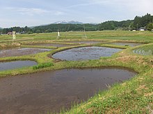
295:. The plain is surrounded by low mountains with heights of around 300 meters, and is a well-watered area with natural springs and the Honedera River flowing eastward through the plain to the Iwai River. The
33:
78:
441:
291:
The
Honederamura Shōen ruins are located in the Genbi neighborhood of Ichinoseki City on a terraced plain on the left bank of the Iwai River east from
377:
488:
135:
478:
50:
493:
419:
401:
483:
365:
473:
324:
254:
448:
339:
280:
223:
453:
328:
268:
109:
314:
272:
178:
123:
264:
201:
303:
and was originally a donation by the monk Jizaibō Renkō to provide for the upkeep of the
292:
467:
347:
356:
300:
397:
310:
415:
458:
305:
336:
150:
137:
343:
436:
319:
259:
276:
113:
279:. A portion of the site (48.8 hectares) was designated a
364:
central portion of 366 hectares has been designated an
323:
from Chuzon-ji, an arrangement with continued after
212:
207:
197:
192:
184:
174:
166:
129:
119:
105:
368:under the Cultural Properties Protection Act.
244:
238:
267:, located in what is now part of the city of
8:
342:, the estate came under the control of the
19:
85:
57:
32:
18:
389:
378:List of Historic Sites of Japan (Iwate)
257:containing the ruins of a large-scale
7:
331:clan and redrew the borders of the
442:Ichinoseki-Hondera rural landscape
14:
435:
84:
77:
56:
49:
281:National Historic Site of Japan
224:National Historic Site of Japan
1:
489:Archaeological sites in Japan
449:Ichinoseki city official site
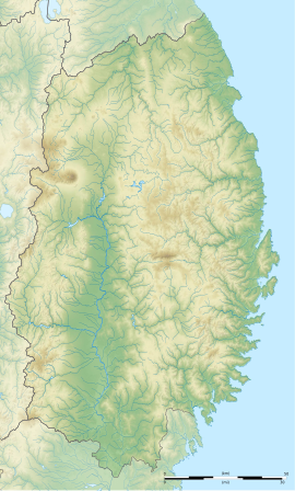
366:Important cultural landscape
68:Show map of Iwate Prefecture
479:History of Iwate Prefecture
420:Agency for Cultural Affairs
402:Agency for Cultural Affairs
245:
510:
317:. It as administered by a
93:Honederamura Shōen (Japan)
239:
220:
43:
31:
24:
246:Honederamura Shōen iseki
234:Honederamura Shōen ruins
170:110 m (361 ft)
38:Honederamura Shōen ruins
494:Historic Sites of Japan
151:38.98167°N 140.95167°E
444:at Wikimedia Commons
309:sutra repository at
325:Minamoto no Yoritomo
299:dates from the late
255:archaeological site
156:38.98167; 140.95167
147: /
21:
459:Official Home Page
454:Official guidebook
340:Tokugawa shogunate
213:Public access
20:Honederamura Shōen
16:Archeological Site
484:Ichinoseki, Iwate
440:Media related to
329:Northern Fujiwara
269:Ichinoseki, Iwate
231:
230:
110:Ichinoseki, Iwate
96:Show map of Japan
65:Location in Japan
501:
439:
424:
423:
412:
406:
405:
394:
327:defeated of the
252:
251:
248:
242:
241:
162:
161:
159:
158:
157:
152:
148:
145:
144:
143:
140:
97:
88:
87:
81:
69:
60:
59:
53:
36:
22:
509:
508:
504:
503:
502:
500:
499:
498:
474:Kamakura period
464:
463:
433:
428:
427:
418:(in Japanese).
414:
413:
409:
400:(in Japanese).
396:
395:
391:
386:
374:
289:
265:Kamakura period
263:manor from the
249:
236:
227:
226:
202:Kamakura period
155:
153:
149:
146:
141:
138:
136:
134:
133:
101:
100:
99:
98:
95:
94:
91:
90:
89:
72:
71:
70:
67:
66:
63:
62:
61:
39:
27:
17:
12:
11:
5:
507:
505:
497:
496:
491:
486:
481:
476:
466:
465:
462:
461:
456:
451:
432:
431:External links
429:
426:
425:
407:
388:
387:
385:
382:
381:
380:
373:
370:
293:Mount Kurikoma
288:
285:
229:
228:
222:
221:
218:
217:
214:
210:
209:
205:
204:
199:
195:
194:
190:
189:
186:
182:
181:
176:
172:
171:
168:
164:
163:
131:
127:
126:
121:
117:
116:
107:
103:
102:
92:
83:
82:
76:
75:
74:
73:
64:
55:
54:
48:
47:
46:
45:
44:
41:
40:
37:
29:
28:
25:
15:
13:
10:
9:
6:
4:
3:
2:
506:
495:
492:
490:
487:
485:
482:
480:
477:
475:
472:
471:
469:
460:
457:
455:
452:
450:
447:
446:
445:
443:
438:
430:
421:
417:
411:
408:
403:
399:
393:
390:
383:
379:
376:
375:
371:
369:
367:
361:
359:
358:
351:
349:
348:Sendai Domain
345:
341:
338:
334:
330:
326:
322:
321:
316:
312:
308:
307:
302:
298:
294:
286:
284:
282:
278:
274:
273:Tōhoku region
270:
266:
262:
261:
256:
247:
235:
225:
219:
215:
211:
206:
203:
200:
196:
191:
188:48.8 hectares
187:
183:
180:
177:
173:
169:
165:
160:
132:
128:
125:
124:Tōhoku region
122:
118:
115:
111:
108:
104:
80:
52:
42:
35:
30:
23:
434:
410:
392:
362:
357:Azuma Kagami
355:
352:
335:. Under the
332:
318:
304:
301:Heian period
296:
290:
258:
233:
232:
416:"一関本寺の農村景観"
154: /
142:140°57′06″E
130:Coordinates
468:Categories
384:References
337:Edo period
208:Site notes
179:settlement
139:38°58′54″N
398:"骨寺村荘園遺跡"
344:Date clan
315:Hiraizumi
311:Chūson-ji
283:in 2005.
372:See also
287:Overview
167:Altitude
106:Location
271:in the
240:骨寺村荘園遺跡
198:Periods
193:History
26:骨寺村荘園遺跡
253:is an
120:Region
333:shōen
320:bettō
306:Kyōzō
297:shōen
277:Japan
260:shōen
114:Japan
185:Area
175:Type
346:of
313:in
275:of
216:Yes
470::
360:.
350:.
243:,
112:,
422:.
404:.
250:)
237:(
Text is available under the Creative Commons Attribution-ShareAlike License. Additional terms may apply.