516:
638:) showcases various volcanic rocks and sedimentary rocks formed about 146 million years ago. The siltstone beds were interbedded with volcanic tuffite. Tuffite is a sedimentary rock with a volcanic origin. It formed by fine volcanic ash deposited in water, forming a sedimentary bed of volcanic ash. Other than that, there is also a black cherty mudstone on Lai Chi Chong, which is believed to be formed by mud deposited together with silica-rich materials. The black color indicated an oxygen depleted deposition environment. These black mudstones beds exhibits a slump fold structure. Large coherent mass of loosely consolidated materials might have slid down along a slope and folded the mudstone beds.
224:
468:
28:
480:
240:
532:
492:
504:
544:
692:
680:
232:
668:
863:
322:
In 2008, the Hong Kong government commissioned a study to investigate the feasibility of establishing a geopark. The study identified two suitable regions, namely the north-eastern New
Territories and Sai Kung. The government subsequently set up a geopark to cover both regions. The geopark was
515:
627:
formed about 280 million years ago. Various fossils such as ammonites, corals and bivalves were found on Ma Shi Chau. Sitting right next to the Tolo
Channel fault system, various sheared features and folds can be observed.
575:. It contains many deep red coloured rocks formed during a period of global warming in Tertiary. Oxidation rate of iron increased due to higher temperature and humidity, forming the iron oxide (rust)
657:
in northeastern Hong Kong. It is the easternmost outlying island of Hong Kong. Tung Ping Chau is a popular holiday destination for locals. Its attractions, such as wave erosion landscape, the
605:, are at the northeastern tip of the Tolo channel. Various deformation and erosion features can be seen from these rocks. One of the famous features is the Devil's fist formed by
789:
467:
479:
371:) is located in southeastern Hong Kong, immediately to the south of the High Island peninsula and to the northwest of the Ninepin group of islands. It consists of
1085:
491:
1310:
852:
503:
1305:
347:) is the home of the columnar-jointed volcanic tuff. Most of the columns are sub-vertical, straight-sided and parallel. It covers a large area around
531:
1300:
1295:
1106:
1014:
1009:
825:
585:), as the Chinese name Chek Chau implies, Port Island is a place of red earth. The ground on the entire island is rust-coloured conglomerate and
223:
1186:
1080:
751:
785:
266:), was inaugurated on 3 November 2009. It is a single entity of land area over 150 km across parts of the eastern and northeastern
453:, from where it can easily be reached by small boat. The island is underlain by older volcanic-related sedimentary rocks. There is a
1114:
1250:
1244:
1226:
992:
845:
691:
661:
that resembles a sponge cake structure and the unusually flat lay of the island itself, draw thousands of visitors annually.
251:
135:
47:
149:
61:
955:
1129:
1124:
1101:
1029:
1004:
422:) is located on the eastern side of Hong Kong, forms a series of offshore islands. Numerous inclined columnar jointed
1232:
1075:
987:
838:
774:
27:
727:
717:
543:
430:
and coastal scenery around the
Ninepin Group. Columns in the Ninepin Group are as large as 3-meters in diameter.
972:
722:
388:
1215:
275:
1238:
967:
927:
356:
340:
239:
601:. The oldest rocks in Hong Kong, the Bluff Head formation, formed about 400 million years ago during the
1266:
1154:
1149:
977:
352:
712:
372:
311:
950:
934:
803:
1169:
1044:
679:
348:
667:
1119:
1034:
866:
698:
624:
571:) is a harbour hugged by Double Island, Crescent Island and Crooked Island with north-eastern
307:
300:
286:
762:
1159:
830:
297:
172:
84:
960:
880:
602:
572:
267:
119:
hoeng1 gong2 lyun4 hap6 gwok3 gaau3 fo1 man4 zou2 zik1 sai3 gaai3 dei6 zat1 gung1 jyun4*2
17:
1164:
1039:
423:
293:
1289:
1221:
912:
907:
890:
885:
631:
450:
415:
380:
227:
Volcanic tuffs with hexagonal columnar jointing at East Dam of High Island
Reservoir
1208:
1203:
895:
598:
564:
446:
438:
324:
179:
91:
616:
231:
1049:
982:
902:
732:
606:
521:
Columnar jointing near Po Pin Chau (not to be confused with the dark-colored
646:
586:
578:
400:
193:
105:
399:
coastline a distinctive appearance, and leading to the development of many
997:
917:
654:
404:
200:
112:
281:
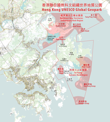
The Hong Kong UNESCO Global
Geopark consists of two geological regions:
610:
454:
306:
the
Northeast New Territories Sedimentary Rock Region, which comprises
862:
613:
along the sandstone bedding forming the shape of the “Ghost fingers”.
922:
427:
271:
509:
Po Pin Chau, a stack island near the High Island
Reservoir East Dam
658:
522:
396:
230:
26:
497:
Twisted columnar jointing near the High Island
Reservoir East Dam
804:"Chief Executive opens Hong Kong National Geopark (with photos)"
458:
290:
834:
395:). Columnar-jointed rocks underlie these islands, giving their
310:
formed in different geologic periods, showcasing the complete
820:
752:
discoverhongkong.com : Hong Kong UNESCO Global
Geopark
98:
Xiānggǎng Liánhéguó Jiào Kē Wén Zǔzhī Shìjiè Dìzhì Gōngyuán
485:
Columnar jointing near the High Island
Reservoir East Dam
473:
Columnar jointing near the High Island Reservoir East Dam
205:
117:
826:
Proposal to set up a Geopark in Hong Kong, March 2009
184:
96:
303:, which are of international geological significance
1259:
1196:
1178:
1142:
1094:
1068:
1061:
1023:
943:
873:
199:
192:
178:
171:
166:
148:
134:
129:
111:
104:
90:
83:
78:
60:
46:
37:
790:Agriculture, Fisheries and Conservation Department
289:Volcanic Rock Region, with its widely distributed
555:Northeast New Territories Sedimentary Rock Region
597:The area includes the north and south shores of
537:Sea Cave near the High Island Reservoir East Dam
243:Devil's Fist at Bluff Head (Wong Chuk Kok Tsui)
207:hoeng1 gong2 gwok3 gaa1 dei6 zat1 gung1 jyun4*2
1086:Hong Kong University of Science and Technology
846:
154:
140:
66:
52:
8:
351:in the eastern part of Hong Kong, including
806:. Government of Hong Kong. 3 November 2009.
775:"Proposal to set up a Geopark in Hong Kong"
1065:
1020:
861:
853:
839:
831:
163:
75:
457:reaching to a small island nearby at low
1107:French International School of Hong Kong
323:formally inaugurated by Chief Executive
238:
222:
1015:Public housing estates in Tseung Kwan O
1010:Historic churches of Sai Kung Peninsula
821:Hong Kong UNESCO Global Geopark website
744:
663:
463:
1187:Sai Kung & Clearwater Bay Magazine
593:North and south coasts of Tolo Channel
34:
1081:Caritas Institute of Higher Education
7:
1311:Protected areas established in 2009
786:Environmental Protection Department
589:formed similarly during Teritary.
274:listed the geopark as part of its
25:
1115:HKMLC Queen Maud Secondary School
1306:2009 establishments in Hong Kong
690:
678:
666:
542:
530:
514:
502:
490:
478:
466:
312:geological history of Hong Kong.
1301:Global Geoparks Network members
1296:Hong Kong UNESCO Global Geopark
1269:(fatal injury at Tseung Kwan O)
993:Tseung Kwan O Industrial Estate
248:Hong Kong UNESCO Global Geopark
206:
186:Xiānggǎng Guójiā Dìzhì Gōngyuán
118:
38:Hong Kong UNESCO Global Geopark
650:
635:
620:
582:
568:
442:
419:
392:
384:
376:
368:
344:
263:
255:
185:
155:
141:
97:
67:
53:
1:
331:Sai Kung Volcanic Rock Region
956:Clear Water Bay Country Park
560:Double Haven and Port Island
1130:Hong Kong Adventist College
1125:Hong Kong Adventist Academy
1030:Clear Water Bay First Beach
1005:Tseung Kwan O Sports Ground
1327:
1076:Hong Kong Design Institute
988:Sai Kung East Country Park
449:, to the southeast of the
260:Hong Kong National Geopark
130:Hong Kong National Geopark
1276:
728:List of National Geoparks
718:Conservation in Hong Kong
217:
162:
74:
42:
1278:This list is incomplete.
973:Hong Kong Global Geopark
723:Protected areas of China
270:. On 18 September 2011,
136:Traditional Chinese
48:Traditional Chinese
18:Hong Kong Global Geopark
367:Ung Kong Island Group (
276:Global Geoparks Network
150:Simplified Chinese
62:Simplified Chinese
1214:Leung Shuen Wan Chau (
968:Haven of Hope Hospital
928:Tseung Kwan O New Town
244:
236:
228:
32:
1267:Death of Chow Tsz-lok
978:Kiu Tsui Country Park
353:High Island Reservoir
242:
234:
226:
30:
1110:Tsueng Kwan O Campus
713:Geology of Hong Kong
549:South Ninepin Island
445:) is located in the
327:on 3 November 2009.
951:Cham Shan Monastery
935:Tseung Kwan O South
782:Legislative Council
1045:Silverstrand Beach
567:or Yan Chau Tong (
525:in the foreground)
349:Sai Kung Peninsula
245:
237:
229:
33:
1283:
1282:
1138:
1137:
1120:Hong Kong Academy
1111:
1095:Primary/secondary
1057:
1056:
1035:Hap Mun Bay Beach
867:Sai Kung District
701:on Tung Ping Chau
699:wave-cut platform
625:sedimentary rocks
308:sedimentary rocks
301:columnar jointing
221:
220:
213:
212:
173:Standard Mandarin
125:
124:
85:Standard Mandarin
16:(Redirected from
1318:
1109:
1066:
1021:
865:
855:
848:
841:
832:
808:
807:
800:
794:
793:
792:. February 2009.
779:
771:
765:
760:
754:
749:
694:
682:
670:
652:
637:
622:
584:
570:
546:
534:
518:
506:
494:
482:
470:
444:
421:
394:
386:
378:
370:
346:
265:
257:
256:香港聯合國教科文組織世界地質公園
209:
208:
188:
187:
164:
158:
157:
144:
143:
121:
120:
100:
99:
76:
70:
69:
68:香港联合国教科文组织世界地质公园
56:
55:
54:香港聯合國教科文組織世界地質公園
35:
21:
1326:
1325:
1321:
1320:
1319:
1317:
1316:
1315:
1286:
1285:
1284:
1279:
1272:
1255:
1231:Ngau Mei Chau (
1192:
1174:
1134:
1102:Evangel College
1090:
1053:
1019:
961:Clear Water Bay
939:
881:Clear Water Bay
869:
859:
817:
812:
811:
802:
801:
797:
777:
773:
772:
768:
763:Geopark leaflet
761:
757:
750:
746:
741:
709:
702:
695:
686:
683:
674:
671:
644:
623:) presents the
603:Devonian Period
595:
573:New Territories
562:
557:
550:
547:
538:
535:
526:
519:
510:
507:
498:
495:
486:
483:
474:
471:
436:
413:
365:
338:
333:
320:
268:New Territories
23:
22:
15:
12:
11:
5:
1324:
1322:
1314:
1313:
1308:
1303:
1298:
1288:
1287:
1281:
1280:
1277:
1274:
1273:
1271:
1270:
1263:
1261:
1257:
1256:
1254:
1253:
1248:
1242:
1241:(Sheep Island)
1236:
1233:Shelter Island
1229:
1224:
1219:
1212:
1211:(Sharp Island)
1206:
1200:
1198:
1194:
1193:
1191:
1190:
1182:
1180:
1176:
1175:
1173:
1172:
1167:
1162:
1157:
1152:
1146:
1144:
1140:
1139:
1136:
1135:
1133:
1132:
1127:
1122:
1117:
1112:
1104:
1098:
1096:
1092:
1091:
1089:
1088:
1083:
1078:
1072:
1070:
1063:
1059:
1058:
1055:
1054:
1052:
1047:
1042:
1040:Kiu Tsui Beach
1037:
1032:
1027:
1025:
1018:
1017:
1012:
1007:
1002:
1001:
1000:
990:
985:
980:
975:
970:
965:
964:
963:
953:
947:
945:
941:
940:
938:
937:
932:
931:
930:
925:
920:
910:
905:
900:
899:
898:
888:
883:
877:
875:
871:
870:
860:
858:
857:
850:
843:
835:
829:
828:
823:
816:
815:External links
813:
810:
809:
795:
766:
755:
743:
742:
740:
737:
736:
735:
730:
725:
720:
715:
708:
705:
704:
703:
696:
689:
687:
684:
677:
675:
672:
665:
647:Tung Ping Chau
643:
642:Tung Ping Chau
640:
594:
591:
561:
558:
556:
553:
552:
551:
548:
541:
539:
536:
529:
527:
520:
513:
511:
508:
501:
499:
496:
489:
487:
484:
477:
475:
472:
465:
435:
432:
424:volcanic rocks
412:
409:
364:
363:Ung Kong Group
361:
337:
334:
332:
329:
319:
316:
315:
314:
304:
294:volcanic rocks
235:Tung Ping Chau
219:
218:
215:
214:
211:
210:
203:
197:
196:
194:Yue: Cantonese
190:
189:
182:
176:
175:
169:
168:
167:Transcriptions
160:
159:
152:
146:
145:
138:
132:
131:
127:
126:
123:
122:
115:
109:
108:
106:Yue: Cantonese
102:
101:
94:
88:
87:
81:
80:
79:Transcriptions
72:
71:
64:
58:
57:
50:
44:
43:
40:
39:
24:
14:
13:
10:
9:
6:
4:
3:
2:
1323:
1312:
1309:
1307:
1304:
1302:
1299:
1297:
1294:
1293:
1291:
1275:
1268:
1265:
1264:
1262:
1258:
1252:
1249:
1246:
1243:
1240:
1237:
1234:
1230:
1228:
1225:
1223:
1222:Ninepin Group
1220:
1217:
1213:
1210:
1209:Kiu Tsui Chau
1207:
1205:
1202:
1201:
1199:
1195:
1189:
1188:
1184:
1183:
1181:
1177:
1171:
1168:
1166:
1163:
1161:
1158:
1156:
1155:Tseung Kwan O
1153:
1151:
1150:Tiu Keng Leng
1148:
1147:
1145:
1141:
1131:
1128:
1126:
1123:
1121:
1118:
1116:
1113:
1108:
1105:
1103:
1100:
1099:
1097:
1093:
1087:
1084:
1082:
1079:
1077:
1074:
1073:
1071:
1067:
1064:
1060:
1051:
1048:
1046:
1043:
1041:
1038:
1036:
1033:
1031:
1028:
1026:
1022:
1016:
1013:
1011:
1008:
1006:
1003:
999:
996:
995:
994:
991:
989:
986:
984:
981:
979:
976:
974:
971:
969:
966:
962:
959:
958:
957:
954:
952:
949:
948:
946:
942:
936:
933:
929:
926:
924:
921:
919:
916:
915:
914:
913:Tseung Kwan O
911:
909:
908:Tiu Keng Leng
906:
904:
901:
897:
894:
893:
892:
891:Tai Mong Tsai
889:
887:
886:Sai Kung Town
884:
882:
879:
878:
876:
872:
868:
864:
856:
851:
849:
844:
842:
837:
836:
833:
827:
824:
822:
819:
818:
814:
805:
799:
796:
791:
787:
783:
776:
770:
767:
764:
759:
756:
753:
748:
745:
738:
734:
731:
729:
726:
724:
721:
719:
716:
714:
711:
710:
706:
700:
693:
688:
681:
676:
669:
664:
662:
660:
656:
648:
641:
639:
633:
632:Lai Chi Chong
629:
626:
618:
614:
612:
608:
604:
600:
592:
590:
588:
580:
576:
574:
566:
559:
554:
545:
540:
533:
528:
524:
517:
512:
505:
500:
493:
488:
481:
476:
469:
464:
462:
460:
456:
452:
451:Sai Kung Town
448:
440:
433:
431:
429:
425:
417:
416:Ninepin Group
411:Ninepin Group
410:
408:
406:
402:
398:
390:
382:
381:Basalt Island
374:
362:
360:
358:
354:
350:
342:
335:
330:
328:
326:
317:
313:
309:
305:
302:
299:
295:
292:
288:
284:
283:
282:
279:
277:
273:
269:
261:
253:
249:
241:
233:
225:
216:
204:
202:
198:
195:
191:
183:
181:
177:
174:
170:
165:
161:
153:
151:
147:
139:
137:
133:
128:
116:
114:
110:
107:
103:
95:
93:
89:
86:
82:
77:
73:
65:
63:
59:
51:
49:
45:
41:
36:
29:
19:
1251:Yim Tin Tsai
1247:(Urn Island)
1245:Tai Tau Chau
1227:Pak Sha Chau
1204:Kau Sai Chau
1185:
1143:MTR stations
896:Wong Mo Ying
798:
781:
769:
758:
747:
685:Double Haven
645:
630:
615:
599:Tolo Channel
596:
577:
565:Double Haven
563:
447:Port Shelter
439:Sharp Island
437:
434:Sharp Island
414:
389:Bluff Island
366:
357:Tai Long Wan
339:
325:Donald Tsang
321:
280:
259:
258:), formerly
247:
246:
180:Hanyu Pinyin
92:Hanyu Pinyin
31:Overview map
1216:High Island
673:Ma Shi Chau
617:Ma Shi Chau
579:Port Island
341:High Island
336:High Island
296:displaying
1290:Categories
1239:Yeung Chau
1170:LOHAS Park
1050:Trio Beach
983:LOHAS Park
903:Ta Ku Ling
739:References
733:Lai Chi Wo
653:) sits in
607:weathering
405:sea arches
1062:Education
944:Landmarks
587:siltstone
401:sea caves
373:Wang Chau
298:prismatic
1160:Hang Hau
1069:Tertiary
998:TVB City
918:Hang Hau
707:See also
655:Mirs Bay
287:Sai Kung
264:香港國家地質公園
201:Jyutping
156:香港国家地质公园
142:香港國家地質公園
113:Jyutping
1260:History
1197:Islands
1024:Beaches
611:erosion
523:dolosse
455:tombolo
426:create
318:History
252:Chinese
1165:Po Lam
923:Po Lam
428:cliffs
387:) and
272:UNESCO
254::
1179:Media
874:Areas
778:(PDF)
659:shale
397:cliff
788:and
609:and
459:tide
420:果洲群島
403:and
393:沙塘口山
369:甕缸群島
355:and
291:tuff
285:the
651:東平洲
636:荔枝莊
621:馬屎洲
569:印洲塘
443:橋咀洲
385:火石洲
379:),
345:糧船灣
1292::
784:.
780:.
697:A
583:赤洲
461:.
407:.
377:橫洲
359:.
278:.
1235:)
1218:)
854:e
847:t
840:v
649:(
634:(
619:(
581:(
441:(
418:(
391:(
383:(
375:(
343:(
262:(
250:(
20:)
Text is available under the Creative Commons Attribution-ShareAlike License. Additional terms may apply.