40:
17:
94:(2,656 m) is located. The mountain is also the highest in the whole of the Allgäu Alps. In the west the range is bounded along this side branch by a line that reaches from Holzgau in the south, runs along the Höhenbachtal and Rossgumpental valleys to the Öfnerkar in the north. The boundaries of the main ridge of the Hornbach chain are formed in the north by the
29:
458:
405:
453:
380:
311:
The side branch of the
Hornbachspitze - in the extreme west of the chain - branches southwards and includes the following peaks:
114:, where it unites with the Hornbachtal. At the junction of the two valleys lies the easternmost mountain of the group, the
86:
from the main line of the Allgäu Alps and runs in a gentle arc from north to east. In the far west, it branches at the
282:
372:
218:
463:
288:
252:
366:
319:
258:
164:
91:
44:
264:
228:
182:
152:
294:
246:
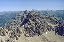
325:
194:
188:
176:
146:
87:
39:
341:
240:
347:
200:
170:
300:
212:
115:
95:
71:
331:
16:
391:
385:
376:
33:
276:
127:
138:
The most important peaks on the main ridge of the
Hornbach chain, from west to east, are:
90:
and a side ridge runs southwards in which the most important peak of the whole chain, the
55:
206:
111:
99:
83:
63:
447:
270:
123:
130:(2,632 m), which are all in the ten most important summits of the Allgäu Alps.
234:
158:
119:
421:
407:
21:
107:
103:
67:
118:. On the main ridge of the Hornbach chain, the highest peaks are the
28:
62:) is a string of mountains, about 15 kilometres long, in the
38:
27:
388:2/1 Allgäuer-Lechtaler Alpen – West (2004 edition)
394:2/2 Allgäuer-Lechtaler Alpen – Ost (2006 edition)
313:
140:
20:Northern view of the Hornbach chain from the
8:
32:The Hornbach chain from the south with the
459:Mountain ranges of Tyrol (federal state)
15:
338:
316:
225:
143:
7:
369:Allgäuer Alpen und Ammergauer Alpen
82:The Hornbach chain branches at the
14:
98:valley with its settlement of
1:
43:The Hornbach chain from the
480:
454:Mountain ranges of Europe
373:Bergverlag Rudolf Rother
126:(2,608 m) and the
102:, in the south by the
59:
47:
36:
25:
422:47.33278°N 10.46222°E
42:
31:
19:
122:(2,609 m), the
417: /
359:Literature and maps
289:Wasserfallkarspitze
427:47.33278; 10.46222
367:Alpenvereinsführer
320:Großer Krottenkopf
253:Woleckleskarspitze
92:Großer Krottenkopf
48:
45:Großer Krottenkopf
37:
26:
392:Alpenvereinskarte
386:Alpenvereinskarte
356:
355:
309:
308:
259:Jungfrauenspitzen
165:Hermannskarspitze
471:
441:
440:
438:
437:
436:
434:
429:
428:
423:
418:
415:
414:
413:
410:
375:, Munich, 2004.
364:Dieter Seibert:
314:
277:Urbeleskarspitze
265:Gliegerkarspitze
229:Bretterkarspitze
183:Wolfebnerspitzen
153:Faulewandspitzen
141:
128:Urbeleskarspitze
479:
478:
474:
473:
472:
470:
469:
468:
444:
443:
432:
430:
426:
424:
420:
419:
416:
411:
408:
406:
404:
403:
401:
361:
295:Schwellenspitze
247:Sattelkarspitze
136:
80:
12:
11:
5:
477:
475:
467:
466:
461:
456:
446:
445:
400:
399:External links
397:
396:
395:
389:
383:
360:
357:
354:
353:
352:
351:
350:– 2,226 m
345:
344:– 2,393 m
337:
336:
335:
334:– 2,388 m
329:
328:– 2,533 m
326:Ramstallspitze
323:
322:– 2,656 m
307:
306:
305:
304:
303:– 2,464 m
298:
297:– 2,496 m
292:
291:– 2,557 m
286:
285:– 2,416 m
280:
279:– 2,632 m
274:
273:– 2,608 m
268:
267:– 2,575 m
262:
261:– 2,390 m
256:
255:– 2,522 m
250:
249:– 2,552 m
244:
243:– 2,206 m
238:
237:– 2,594 m
232:
231:– 2,324 m
224:
223:
222:
221:– 2,262 m
216:
215:– 2,402 m
210:
209:– 2,587 m
207:Kreuzkarspitze
204:
203:– 2,198 m
198:
197:– 2,499 m
195:Balschtespitze
192:
191:– 2,322 m
189:Schöneggerkopf
186:
185:– 2,432 m
180:
179:– 2,493 m
177:Plattenspitzen
174:
173:– 2,552 m
168:
167:– 2,472 m
162:
161:– 2,609 m
156:
155:– 2,480 m
150:
149:– 2,533 m
147:Hornbachspitze
135:
132:
112:Vorderhornbach
100:Hinterhornbach
88:Hornbachspitze
79:
76:
52:Hornbach chain
24:(2,592 m)
13:
10:
9:
6:
4:
3:
2:
476:
465:
462:
460:
457:
455:
452:
451:
449:
442:
439:
433:Bretterspitze
398:
393:
390:
387:
384:
382:
381:3-7633-1126-2
378:
374:
370:
368:
363:
362:
358:
349:
346:
343:
342:Rothornspitze
340:
339:
333:
330:
327:
324:
321:
318:
317:
315:
312:
302:
299:
296:
293:
290:
287:
284:
283:Zwölferspitze
281:
278:
275:
272:
271:Bretterspitze
269:
266:
263:
260:
257:
254:
251:
248:
245:
242:
241:Häselgehrberg
239:
236:
233:
230:
227:
226:
220:
217:
214:
211:
208:
205:
202:
199:
196:
193:
190:
187:
184:
181:
178:
175:
172:
169:
166:
163:
160:
157:
154:
151:
148:
145:
144:
142:
139:
134:List of peaks
133:
131:
129:
125:
124:Bretterspitze
121:
117:
113:
109:
105:
101:
97:
93:
89:
85:
77:
75:
73:
69:
65:
61:
60:Hornbachkette
57:
53:
46:
41:
35:
30:
23:
18:
402:
365:
348:Jöchelspitze
310:
235:Noppenspitze
201:Schreierkopf
171:Ilfenspitzen
137:
81:
51:
49:
464:Allgäu Alps
425: /
301:Klimmspitze
213:Söllerköpfe
159:Marchspitze
120:Marchspitze
116:Klimmspitze
96:Hornbachtal
84:Öfnerspitze
64:Allgäu Alps
448:Categories
431: (
412:10°27′44″E
409:47°19′58″N
332:Strahlkopf
78:Geography
70:state of
22:Hochvogel
68:Austrian
34:Kogelsee
219:Rotwand
108:Holzgau
104:Lechtal
66:in the
379:
56:German
106:from
72:Tyrol
377:ISBN
50:The
110:to
450::
371:.
74:.
58::
435:)
54:(
Text is available under the Creative Commons Attribution-ShareAlike License. Additional terms may apply.