160:
200:
167:
452:
193:
858:
873:
850:
835:
36:
429:
zone with cold, snowy winters, and mild summers. Winter temperatures can drop below −20 °C with wind chill factors below −30 °C. This climate supports the
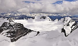
Bugaboo Glacier on the peak's north slope and smaller unnamed glaciers on the east and west slopes.
159:
916:
786:
402:. The peak is named in association with Howser Creek which in turn is named after prospector Fred Hauser who found placer gold there in the late 1800s.
101:
115:
779:
399:
615:
487:
292:
422:
926:
379:
759:
192:
608:
Aerial
Geology; A High-Altitude Tour of North America's Spectacular Volcanoes, Canyons, Glaciers, Lakes, Craters, and Peaks
772:
444:
382:
via Howser Creek. Howser Peak is more notable for its steep rise above local terrain than for its absolute elevation as
108:
682:
289:
819:
921:
579:
911:
584:
386:
is significant with the south aspect rising 1,380 meters (4,527 ft) in 2.5 km (1.6 mi).
367:
259:
249:
73:
63:
662:
636:
86:
711:
307:
574:
295:
882:
815:
737:
383:
320:
96:
729:
611:
483:
426:
273:
824:
719:
456:
363:
239:
284:
715:
398:" by J.M. Thorington in 1947, and it was officially adopted on October 29, 1962, by the
375:
371:
266:
366:, Canada. It is located south of the Bugaboo Glacier and is the southernmost point of
905:
657:
631:
810:
806:
741:
439:
406:
359:
337:
325:
277:
78:
17:
764:
503:
410:
343:
724:
699:
527:
733:
374:
from Howser Peak drains north into
Bugaboo Creek which is a tributary of the
130:
117:
35:
547:
355:
229:
53:
480:
Canadian
Mountain Place Names: The Rockies and Columbia Mountains
478:
Glen W. Boles, William Lowell Putnam, Roger W. Laurilla (2006),
768:
700:"Updated world map of the Köppen−Geiger climate classification"
313:
396:
A Climber's Guide to the
Interior Ranges of British Columbia
698:
Peel, M. C.; Finlayson, B. L.; McMahon, T. A. (2007).
336:
331:
319:
306:
301:
283:
265:
255:
245:
235:
225:
146:
107:
95:
85:
72:
62:
52:
47:
28:
780:
8:
409:of the peak was made on August 28, 1916, by
787:
773:
765:
25:
723:
394:The mountain's toponym was published in "
626:
624:
602:
600:
569:
567:
474:
472:
468:
917:Three-thousanders of British Columbia
7:
802:
498:
496:
23:Mountain in British Columbia, Canada
199:
166:
400:Geographical Names Board of Canada
42:(Marmolata left and Flattop right)
14:
413:and Captain Albert H. MacCarthy.
871:
856:
848:
833:
450:
198:
191:
165:
158:
34:
504:"Howser Peak, British Columbia"
354:is a 3,094-metre (10,151-foot)
795:Places adjacent to Howser Peak
425:, Howser Peak is located in a
1:
872:
834:
606:Mary Caperton Morton (2017),
445:Geography of British Columbia
423:Köppen climate classification
102:Mountains of British Columbia
58:3,094 m (10,151 ft)
857:
849:
580:Geographical Names Data Base
528:"Howser Peak, Peakvisor.com"
182:Show map of British Columbia
179:Location in British Columbia
91:2.96 km (1.84 mi)
943:
548:"Howser Peak - 10,111' BC"
15:
800:
725:10.5194/hess-11-1633-2007
151:
33:
687:, Americanalpineclub.org
585:Natural Resources Canada
482:, Rocky Mountain Books,
68:262 m (860 ft)
16:Not to be confused with
704:Hydrol. Earth Syst. Sci
683:Eaton Cromwell (1931),
368:Bugaboo Provincial Park
260:Bugaboo Provincial Park
927:Kootenay Land District
378:; as well as south to
250:Kootenay Land District
131:50.70472°N 116.78361°W
40:North aspect, centered
663:BC Geographical Names
637:BC Geographical Names
685:In the Bugaboo Group
457:Mountains portal
212:Howser Peak (Canada)
136:50.70472; -116.78361
716:2007HESS...11.1633P
256:Protected area
127: /
883:The Four Squatters
384:topographic relief
215:Show map of Canada
48:Highest point
922:Purcell Mountains
899:
898:
894:
893:
427:subarctic climate
349:
348:
314:Million years ago
274:Purcell Mountains
934:
875:
874:
860:
859:
852:
851:
837:
836:
825:Anniversary Peak
803:
789:
782:
775:
766:
746:
745:
727:
710:(5): 1633–1644.
695:
689:
680:
674:
673:
671:
670:
654:
648:
647:
645:
644:
628:
619:
610:, Timber Press,
604:
595:
594:
592:
591:
571:
562:
561:
559:
558:
544:
538:
537:
535:
534:
524:
518:
517:
515:
514:
500:
491:
476:
455:
454:
453:
370:. Precipitation
364:British Columbia
269:
240:British Columbia
216:
202:
201:
195:
183:
169:
168:
162:
142:
141:
139:
138:
137:
132:
128:
125:
124:
123:
120:
38:
26:
942:
941:
937:
936:
935:
933:
932:
931:
912:Columbia Valley
902:
901:
900:
895:
861:
816:Marmolata Spire
809:
796:
793:
755:
750:
749:
697:
696:
692:
681:
677:
668:
666:
656:
655:
651:
642:
640:
630:
629:
622:
605:
598:
589:
587:
573:
572:
565:
556:
554:
552:listsofjohn.com
546:
545:
541:
532:
530:
526:
525:
521:
512:
510:
502:
501:
494:
477:
470:
465:
451:
449:
436:
419:
392:
276:
267:
221:
220:
219:
218:
217:
214:
213:
210:
209:
208:
207:
203:
186:
185:
184:
181:
180:
177:
176:
175:
174:
170:
135:
133:
129:
126:
121:
118:
116:
114:
113:
43:
41:
24:
21:
12:
11:
5:
940:
938:
930:
929:
924:
919:
914:
904:
903:
897:
896:
892:
891:
888:
885:
879:
878:
876:
869:
866:
865:
862:
847:
845:
841:
840:
838:
831:
828:
827:
822:
813:
801:
798:
797:
794:
792:
791:
784:
777:
769:
763:
762:
754:
753:External links
751:
748:
747:
690:
675:
658:"Howser Creek"
649:
620:
596:
563:
539:
519:
508:Peakbagger.com
492:
467:
466:
464:
461:
460:
459:
447:
442:
435:
432:
418:
415:
391:
388:
376:Columbia River
347:
346:
340:
334:
333:
329:
328:
323:
317:
316:
310:
304:
303:
299:
298:
287:
281:
280:
271:
263:
262:
257:
253:
252:
247:
243:
242:
237:
233:
232:
227:
223:
222:
211:
205:
204:
197:
196:
190:
189:
188:
187:
178:
172:
171:
164:
163:
157:
156:
155:
154:
153:
152:
149:
148:
144:
143:
111:
105:
104:
99:
93:
92:
89:
83:
82:
81:(3,412 m)
76:
70:
69:
66:
60:
59:
56:
50:
49:
45:
44:
39:
31:
30:
22:
13:
10:
9:
6:
4:
3:
2:
939:
928:
925:
923:
920:
918:
915:
913:
910:
909:
907:
889:
886:
884:
881:
880:
877:
870:
868:
867:
864:Bugaboo Creek
863:
855:
846:
843:
842:
839:
832:
830:
829:
826:
823:
821:
820:Hound's Tooth
817:
814:
812:
808:
805:
804:
799:
790:
785:
783:
778:
776:
771:
770:
767:
761:
758:Howser Peak:
757:
756:
752:
743:
739:
735:
731:
726:
721:
717:
713:
709:
705:
701:
694:
691:
688:
686:
679:
676:
665:
664:
659:
653:
650:
639:
638:
633:
632:"Howser Peak"
627:
625:
621:
617:
616:9781604698350
613:
609:
603:
601:
597:
586:
582:
581:
576:
575:"Howser Peak"
570:
568:
564:
553:
549:
543:
540:
529:
523:
520:
509:
505:
499:
497:
493:
489:
488:9781894765794
485:
481:
475:
473:
469:
462:
458:
448:
446:
443:
441:
438:
437:
433:
431:
428:
424:
421:Based on the
416:
414:
412:
408:
403:
401:
397:
389:
387:
385:
381:
377:
373:
369:
365:
361:
357:
353:
345:
341:
339:
335:
330:
327:
324:
322:
318:
315:
311:
309:
305:
300:
297:
294:
291:
288:
286:
282:
279:
275:
272:
270:
264:
261:
258:
254:
251:
248:
244:
241:
238:
234:
231:
228:
224:
194:
161:
150:
145:
140:
112:
110:
106:
103:
100:
98:
94:
90:
88:
84:
80:
77:
75:
71:
67:
65:
61:
57:
55:
51:
46:
37:
32:
27:
19:
890:Bugaboo Pass
887:Howser Creek
853:
811:Flattop Peak
807:Howser Spire
707:
703:
693:
684:
678:
667:. Retrieved
661:
652:
641:. Retrieved
635:
607:
588:. Retrieved
578:
555:. Retrieved
551:
542:
531:. Retrieved
522:
511:. Retrieved
507:
479:
440:The Bugaboos
420:
407:first ascent
404:
395:
393:
380:Duncan River
360:The Bugaboos
351:
350:
338:First ascent
326:Granodiorite
321:Type of rock
296:Howser Creek
278:The Bugaboos
268:Parent range
79:Howser Spire
18:Howser Spire
854:Howser Peak
411:Conrad Kain
352:Howser Peak
344:Conrad Kain
308:Age of rock
206:Howser Peak
173:Howser Peak
134: /
122:116°47′01″W
109:Coordinates
74:Parent peak
29:Howser Peak
906:Categories
844:East Creek
669:2023-02-08
643:2023-02-08
590:2023-02-08
557:2023-02-08
533:2023-02-08
513:2023-02-08
463:References
119:50°42′17″N
64:Prominence
734:1027-5606
490:, p. 127.
147:Geography
87:Isolation
54:Elevation
434:See also
342:1916 by
332:Climbing
285:Topo map
246:District
236:Province
760:weather
742:9654551
712:Bibcode
618:, p. 42
417:Climate
390:History
302:Geology
226:Country
97:Listing
740:
732:
614:
486:
372:runoff
356:summit
230:Canada
738:S2CID
293:82K10
730:ISSN
612:ISBN
484:ISBN
405:The
312:135
720:doi
362:of
358:in
290:NTS
908::
736:.
728:.
718:.
708:11
706:.
702:.
660:.
634:.
623:^
599:^
583:.
577:.
566:^
550:.
506:.
495:^
471:^
818:/
788:e
781:t
774:v
744:.
722::
714::
672:.
646:.
593:.
560:.
536:.
516:.
20:.
Text is available under the Creative Commons Attribution-ShareAlike License. Additional terms may apply.