911:
601:
45:
62:
95:
102:
69:
333:
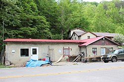
The Smoot Creek post office serviced a community in
Letcher County near Smoot Creek waterway from 1890 to 1914. The post office moved with coal camps, changing names to Dalna in 1918 and Elsiecoal in 1923. In 1932, Hot Spot was named for the Hot Spot Coal Company. It since has frequently been noted
971:
952:
524:
986:
976:
945:
517:
465:
130:
262:
94:
44:
938:
510:
438:
61:
334:
on lists of unusual place names. Its associated post office was renamed
Premium in 1942. The Premium post office closed in 2022.
213:
981:
785:
404:
310:
502:
430:
Welcome to
Horneytown, North Carolina, Population: 15: An insider's guide to 201 of the world's weirdest and wildest places
184:
910:
918:
680:
534:
278:
250:
189:
162:
394:
372:
881:
858:
612:
775:
760:
580:
665:
888:
590:
556:
293:, United States. It was named for the Hot Spot Coal Company. Other names for the community have been
223:
795:
790:
645:
635:
630:
625:
35:
863:
820:
780:
755:
735:
710:
685:
655:
322:
428:
815:
810:
770:
715:
690:
670:
660:
620:
585:
575:
461:
434:
400:
922:
455:
853:
835:
825:
800:
730:
725:
720:
705:
695:
830:
700:
675:
805:
765:
750:
286:
965:
745:
255:
868:
549:
845:
373:
U.S. Geological Survey
Geographic Names Information System: Hot Spot, Kentucky
172:
145:
132:
282:
204:
481:
290:
238:
177:
351:
230:
209:
567:
506:
600:
599:
926:
972:
Unincorporated communities in
Letcher County, Kentucky
454:
Strecker, Zoe; Finch, Jackie
Sheckler (July 1, 2009).
844:
644:
611:
566:
261:
249:
237:
220:
203:
195:
183:
171:
161:
26:
21:
Unincorporated community in
Kentucky, United States
16:
Unincorporated community in
Kentucky, United States
946:
518:
399:. University Press of Kentucky. p. 145.
8:
309:. It has frequently been noted on lists of
953:
939:
525:
511:
503:
23:
987:Letcher County, Kentucky geography stubs
460:. Rowman & Littlefield. p. 11.
321:Hot Spot is located near Smoot Creek on
343:
236:
202:
194:
160:
125:
53:
41:
977:Unincorporated communities in Kentucky
260:
248:
219:
182:
170:
7:
907:
905:
604:Location of Letcher County, Kentucky
388:
386:
384:
382:
380:
925:. You can help Knowledge (XXG) by
533:Municipalities and communities of
14:
909:
101:
100:
93:
68:
67:
60:
43:
1:
117:Show map of the United States
114:Location in the United States
921:state location article is a
457:Kentucky Off the Beaten Path
433:. Adams Media. pp. x.
393:Rennick, Robert M. (1987).
1003:
904:
199:1,066 ft (325 m)
877:
597:
547:
126:
54:
42:
33:
919:Letcher County, Kentucky
536:Letcher County, Kentucky
427:Parker, Quentin (2010).
279:unincorporated community
36:Unincorporated community
354:. zipdatamaps.com. 2022
982:Coal towns in Kentucky
605:
603:
222: • Summer (
146:37.12750°N 82.91667°W
890:United States portal
482:"Hot Spot, Kentucky"
396:Kentucky Place Names
84:Show map of Kentucky
81:Location in Kentucky
311:unusual place names
151:37.12750; -82.91667
142: /
606:
352:"Premium ZIP Code"
323:Kentucky Route 160
49:Former post office
28:Hot Spot, Kentucky
934:
933:
899:
898:
467:978-0-7627-5790-9
272:
271:
994:
955:
948:
941:
913:
906:
891:
884:
602:
559:
552:
542:
537:
527:
520:
513:
504:
497:
496:
494:
492:
478:
472:
471:
451:
445:
444:
424:
418:
417:
415:
413:
390:
375:
370:
364:
363:
361:
359:
348:
227:
157:
156:
154:
153:
152:
147:
143:
140:
139:
138:
135:
118:
104:
103:
97:
85:
71:
70:
64:
47:
24:
1002:
1001:
997:
996:
995:
993:
992:
991:
962:
961:
960:
959:
902:
900:
895:
889:
883:Kentucky portal
882:
873:
840:
647:
640:
607:
595:
562:
557:
550:
543:
540:
535:
531:
501:
500:
490:
488:
486:www.kyatlas.com
480:
479:
475:
468:
453:
452:
448:
441:
426:
425:
421:
411:
409:
407:
392:
391:
378:
371:
367:
357:
355:
350:
349:
345:
340:
331:
319:
245:
221:
150:
148:
144:
141:
136:
133:
131:
129:
128:
122:
121:
120:
119:
116:
115:
112:
111:
110:
109:
105:
88:
87:
86:
83:
82:
79:
78:
77:
76:
72:
50:
38:
29:
22:
17:
12:
11:
5:
1000:
998:
990:
989:
984:
979:
974:
964:
963:
958:
957:
950:
943:
935:
932:
931:
914:
897:
896:
894:
893:
886:
878:
875:
874:
872:
871:
866:
861:
856:
850:
848:
842:
841:
839:
838:
833:
828:
823:
818:
813:
808:
803:
798:
793:
788:
783:
778:
773:
768:
763:
758:
753:
748:
743:
738:
733:
728:
723:
718:
713:
708:
703:
698:
693:
688:
683:
681:Defeated Creek
678:
673:
668:
663:
658:
652:
650:
646:Unincorporated
642:
641:
639:
638:
633:
628:
623:
617:
615:
609:
608:
598:
596:
594:
593:
588:
583:
578:
572:
570:
564:
563:
548:
545:
544:
532:
530:
529:
522:
515:
507:
499:
498:
473:
466:
446:
439:
419:
405:
376:
365:
342:
341:
339:
336:
330:
327:
318:
315:
287:Letcher County
270:
269:
266:
259:
258:
253:
247:
246:
243:
241:
235:
234:
228:
218:
217:
207:
201:
200:
197:
193:
192:
187:
181:
180:
175:
169:
168:
165:
159:
158:
124:
123:
113:
107:
106:
99:
98:
92:
91:
90:
89:
80:
74:
73:
66:
65:
59:
58:
57:
56:
55:
52:
51:
48:
40:
39:
34:
31:
30:
27:
20:
15:
13:
10:
9:
6:
4:
3:
2:
999:
988:
985:
983:
980:
978:
975:
973:
970:
969:
967:
956:
951:
949:
944:
942:
937:
936:
930:
928:
924:
920:
915:
912:
908:
903:
892:
887:
885:
880:
879:
876:
870:
867:
865:
862:
860:
859:Indian Bottom
857:
855:
852:
851:
849:
847:
843:
837:
834:
832:
829:
827:
824:
822:
819:
817:
814:
812:
809:
807:
804:
802:
799:
797:
794:
792:
789:
787:
784:
782:
779:
777:
774:
772:
769:
767:
764:
762:
759:
757:
754:
752:
749:
747:
744:
742:
739:
737:
734:
732:
729:
727:
724:
722:
719:
717:
714:
712:
709:
707:
704:
702:
699:
697:
694:
692:
689:
687:
684:
682:
679:
677:
674:
672:
669:
667:
664:
662:
659:
657:
654:
653:
651:
649:
643:
637:
634:
632:
629:
627:
624:
622:
619:
618:
616:
614:
610:
592:
589:
587:
584:
582:
579:
577:
574:
573:
571:
569:
565:
561:
560:
553:
546:
541:United States
538:
528:
523:
521:
516:
514:
509:
508:
505:
491:September 10,
487:
483:
477:
474:
469:
463:
459:
458:
450:
447:
442:
440:9781440507397
436:
432:
431:
423:
420:
408:
402:
398:
397:
389:
387:
385:
383:
381:
377:
374:
369:
366:
353:
347:
344:
337:
335:
328:
326:
324:
316:
314:
312:
308:
304:
300:
296:
292:
288:
284:
280:
276:
267:
264:
257:
254:
252:
242:
240:
232:
229:
225:
215:
214:Eastern (EST)
211:
208:
206:
198:
191:
188:
186:
179:
176:
174:
167:United States
166:
164:
155:
127:Coordinates:
96:
63:
46:
37:
32:
25:
19:
927:expanding it
916:
901:
776:Little Colly
761:Kingdom Come
740:
581:Fleming-Neon
555:
489:. Retrieved
485:
476:
456:
449:
429:
422:
410:. Retrieved
395:
368:
358:November 11,
356:. Retrieved
346:
332:
320:
306:
302:
298:
294:
274:
273:
18:
846:Ghost towns
666:Carbon Glow
648:communities
551:County seat
317:Description
295:Smoot Creek
281:and former
149: /
966:Categories
591:Whitesburg
558:Whitesburg
406:0813126312
338:References
265:feature ID
796:Partridge
791:Oven Fork
636:Payne Gap
631:Millstone
626:McRoberts
412:April 28,
303:Elsiecoal
283:coal town
251:Area code
205:Time zone
196:Elevation
137:82°55′0″W
134:37°7′39″N
864:Red Star
821:Thornton
781:Linefork
756:Jeremiah
741:Hot Spot
736:Hemphill
711:Farraday
686:Democrat
656:Beefhide
291:Kentucky
275:Hot Spot
239:ZIP code
178:Kentucky
108:Hot Spot
75:Hot Spot
816:Skyline
811:Sergent
771:Letcher
716:Gaskill
691:Dongola
671:Cromona
661:Burdine
621:Mayking
586:Jenkins
576:Blackey
329:History
307:Premium
190:Letcher
163:Country
854:Hubert
836:Whitco
826:Tillie
801:Roxana
731:Hallie
726:Gordon
721:Gilley
706:Ermine
696:Dunham
568:Cities
464:
437:
403:
305:, and
277:is an
268:494624
185:County
917:This
831:Ulvah
701:Eolia
676:Deane
299:Dalna
244:41845
233:(EDT)
231:UTC-4
210:UTC-5
173:State
923:stub
806:Seco
786:Neon
766:Kona
751:Isom
613:CDPs
493:2019
462:ISBN
435:ISBN
414:2013
401:ISBN
360:2022
263:GNIS
746:Ice
285:in
256:606
224:DST
968::
869:Uz
554::
539:,
484:.
379:^
325:.
313:.
301:,
297:,
289:,
954:e
947:t
940:v
929:.
526:e
519:t
512:v
495:.
470:.
443:.
416:.
362:.
226:)
216:)
212:(
Text is available under the Creative Commons Attribution-ShareAlike License. Additional terms may apply.