215:) should receive a level of protection. Accordingly, the government designated these areas as "national park direction areas", giving powers for planning decisions taken by local authorities to be reviewed by central government. Following a further review of landscape protection in 1978, additional areas, including the northern part of the island of Hoy and the western part of the Orkney mainland, were identified as worthy of protection due to their landscape qualities. Accordingly, in 1981 the direction areas were replaced by the national scenic area designation, which were based on the 1978 recommendations and thus included the area entitled Hoy and West Mainland. The defined area remains as originally mapped in 1978, but was redesignated under new legislation in 2010.
330:
44:
1604:
28:
276:
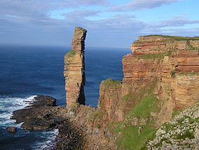
The dramatic coastline of Hoy greets visitors travelling to Orkney by ferry from the
Scottish mainland. It has extremes of many kinds: some of the highest sea cliffs in the UK at St John's Head, which reach 350 m; a light-stone precarious sea stack taller than the facing cliff – the
159:
National scenic areas are primarily designated due to the scenic qualities of an area, however NSAs may well have other special qualities, for example related to culture, history, archaeology, geology or wildlife. Areas with such qualities may be protected via other national and international
152:, as well as parts of the surrounding sea. It is one of 40 such areas in Scotland, which are defined so as to identify areas of exceptional scenery and to ensure its protection by restricting certain forms of development. The Hoy and West Mainland NSA covers 24,407
260:
The bold, rounded hills of North Hoy are a dominant feature across the area, and contrast with the pastoral landscape of West
Mainland. Human activity has played an important part in producing the current landscape, with the
1120:
778:
597:
705:
647:
727:
1399:
1235:
926:
1342:
70:
187:, a committee, chaired by Sir Douglas Ramsay, was established to consider preservation of the landscape in Scotland. The report, published in 1945 proposed that five areas (
575:
400:– a stone circle 104 metres in diameter, originally composed of 60 stones set within a circular ditch up to 3 metres deep and 10 metres wide, forming a
1564:
1469:
318:
of geology, topography, archaeology and land use". The area shows evidence of having been settled and farmed for many thousands of years. The view of the town of
651:
1463:
1290:
1203:
196:
188:
1628:
1347:
1147:
218:
Although the national scenic area designation provides a degree of additional protection via the planning process, there are no bodies equivalent to a
527:
161:
814:
1522:
862:
1633:
967:
891:
507:. The area is important for it seabird assemblage, which regularly supports 120,000 individual seabirds during the breeding season.
437:
in Orkney that is cut from stone rather than built from stones and may be the only example of a
Neolithic rock-cut tomb in Britain.
673:
941:
843:
1156:
133:
1140:
983:
446:
168:
910:
383:
1643:
1484:
1133:
338:
266:
253:
1176:
223:
156:
in total, consisting of 16,479 ha of land with a further 7928 ha being marine (i.e. below low tide).
1550:
1273:
480:
468:
219:
172:
531:
492:
287:
227:
453:
The entire Hoy portion of the NSA is designated as an SAC, primarily for its upland and coastal habitats.
1245:
231:
329:
1638:
749:
1580:
350:
164:
463:
The Loch of
Stenness is designated as an SAC due to its marine species (including marine mammals).
1409:
992:
504:
281:; patches of northernmost scattered, hardy woodland and the remote possibility of locally extant
1455:
1317:
1230:
963:
887:
810:
426:
230:) can produce a management strategy for each one, only the three national scenic areas within
204:
859:
1509:
496:
433:, which lies in the Rackwick valley on the edge of the national scenic area. It is the only
300:
270:
249:
184:
141:
43:
1608:
1190:
945:
914:
866:
847:
500:
467:
The Hoy portion of the NSA, along with much of the adjoining sea area, is designated as a
411:
397:
369:
361:
304:
680:
1419:
1391:
1332:
1258:
1198:
938:
840:
434:
419:
401:
322:, and its link with the sea were also identified as "special qualities" of the area by
308:
292:
278:
145:
54:
33:
1622:
1427:
1307:
1214:
1168:
430:
418:
There are also neolithic remains on Hoy, the most prominent of which is a megalithic
365:
269:
sitting at the heart of the scattered farm steadings and stone dykes surrounding the
1125:
1225:
804:
488:
282:
212:
160:
designations that overlap with the NSA designation. Hoy and West
Mainland includes
1095:
345:
monuments found in the West
Mainland portion of the area. The name was adopted by
1588:
1558:
1517:
1475:
1362:
1357:
1352:
1312:
1253:
1219:
472:
245:
208:
200:
137:
1488:
1480:
1404:
1380:
1337:
1296:
1263:
829:
484:
407:
404:. It has been estimated that the structure took 80,000 man-hours to construct.
323:
315:
314:
West
Mainland by contrast presents a softer landscape, described by SNH as "a
296:
192:
121:
27:
85:
72:
1570:
1494:
1180:
907:
457:
342:
319:
262:
1540:
1532:
1327:
1209:
1160:
1073:
1051:
1029:
1007:
553:
460:
is designated as an SAC due to its fens, heaths and vegetated sea cliffs.
423:
387:
357:
153:
149:
58:
1498:
1322:
1302:
1285:
373:
1437:
1281:
476:
346:
987:
625:
1372:
391:
377:
328:
353:
in 1999. The site of patrimony currently consists of four sites:
1129:
307:, never used in combat. The highest point in the archipelago,
368:, aligned so that its central chamber is illuminated on the
394:, the largest of which is 6 metres (19 ft) high.
291:) documented in 1908 at Heldale Water. The most northerly
706:"National Scenic Areas: background, guidance and policy"
471:
due to its importance for nine breeding bird species:
962:. Newton Abbott: David and Charles Ltd. p. 48.
779:"The special qualities of the National Scenic Areas"
650:. Cairngorms National Park Authority. Archived from
598:"The special qualities of the National Scenic Areas"
1579:
1549:
1531:
1508:
1454:
1436:
1418:
1390:
1371:
1272:
1244:
1189:
1167:
1098:. Joint Nature Conservation Committee. 21 July 2005
784:. Scottish Natural Heritage. 2010. pp. 286–294
456:638 ha of heath and coast to the northwest of
117:
109:
101:
64:
50:
20:
1121:The special qualities of the National Scenic Areas
728:"Development management and National Scenic Areas"
36:, at the western side of Hoy, seen from the south.
648:"History Leading to the Cairngorms National Park"
295:stand here built to defend the south entrance to
877:
875:
752:. Dumfries and Galloway council. 8 December 2017
1141:
8:
960:Orkney and Shetland: An Archaeological Guide
929:Historic Scotland. Retrieved 16 August 2009.
773:
771:
769:
767:
603:. Scottish Natural Heritage. 2010. p. 2
554:"Hoy and West Mainland National Scenic Area"
376:who left one of the largest collections of
1148:
1134:
1126:
620:
618:
21:Hoy and West Mainland National Scenic Area
17:
917:. Orkneyjar. Retrieved 16 September 2008.
869:. Orkneyjar. Retrieved 16 September 2008.
850:. Orkneyjar. Retrieved 11 February 2008.
809:. Edinburgh: Canongate. pp. 344–6.
530:. SNH. 20 December 2010. Archived from
516:
136:(NSA) covering parts of the islands of
886:. Edinburgh: Birlinn. pp. 28–29.
522:
520:
410:– a cluster of eight houses making up
337:The national scenic area includes the
7:
414:’s best-preserved Neolithic village.
349:when it proclaimed these sites as a
234:have current management strategies.
179:Creation of the national scenic area
49:
167:in Scotland, and there are several
1400:South Lewis, Harris and North Uist
14:
1629:National scenic areas of Scotland
1236:Scarba, Lunga and the Garvellachs
948:Orkneyjar. Retrieved 27 May 2010.
927:"Skara Brae Prehistoric Village"
908:" The Ring o' Brodgar, Stenness "
860:"The Standing Stones o' Stenness"
422:carved out of a titanic block of
1602:
1030:"Stromness Heaths and Coast SAC"
882:Wickham-Jones, Caroline (2007).
333:The Standing Stones of Stenness.
105:244 km (94 sq mi)
42:
26:
1343:Morar, Moidart and Ardnamurchan
303:in 1814 towards the end of the
108:
803:Haswell-Smith, Hamish (2004).
750:"National Scenic Areas (NSAs)"
674:"National Scenic Areas Review"
528:"National Scenic Areas - Maps"
197:Glen Coe-Ben Nevis-Black Mount
1:
984:Historic Environment Scotland
447:Special Areas of Conservation
189:Loch Lomond and the Trossachs
169:Special Areas of Conservation
988:"Hoy, Dwarfie Stane (1597)"
679:. SNH. 1997. Archived from
384:Standing Stones of Stenness
1660:
1565:Loch Rannoch and Glen Lyon
1470:Loch Rannoch and Glen Lyon
884:Orkney: A Historical Guide
441:Conservations designations
380:inscriptions in the world.
1634:Protected areas of Orkney
1598:
339:Heart of Neolithic Orkney
324:Scottish Natural Heritage
267:Heart of Neolithic Orkney
254:Heart of Neolithic Orkney
41:
25:
939:"The Dwarfie Stane, Hoy"
173:Special Protection Areas
1096:"SPA Description (Hoy)"
626:"Sitelink - Map Search"
576:"National Scenic Areas"
481:great black-backed gull
469:Special Protection Area
220:national park authority
1464:Ben Nevis and Glen Coe
1291:Ben Nevis and Glen Coe
1204:Ben Nevis and Glen Coe
1052:"Loch of Stenness SAC"
493:black-legged kittiwake
449:(SAC) within the NSA:
334:
288:Salvelinus inframundus
228:Orkney Islands Council
1518:Eildon and Leaderfoot
1446:Hoy and West Mainland
1348:North West Sutherland
1246:Dumfries and Galloway
1157:National scenic areas
958:Laing, Lloyd (1974).
386:– the four remaining
332:
238:Landscape and scenery
232:Dumfries and Galloway
130:Hoy and West Mainland
1254:East Stewartry Coast
944:2 March 2012 at the
913:15 July 2017 at the
846:16 June 2017 at the
806:The Scottish Islands
165:World Heritage Sites
134:national scenic area
1609:Scotland portal
1581:West Dunbartonshire
865:7 June 2017 at the
429:, and known as the
372:. It was looted by
351:World Heritage Site
118:Governing body
82: /
1405:South Uist Machair
1392:Na h-Eileanan Siar
686:on 6 February 2018
654:on 15 January 2018
505:red-throated diver
335:
1616:
1615:
1456:Perth and Kinross
1318:Glen Strathfarrar
816:978-1-84195-454-7
427:Old Red Sandstone
265:monuments of the
224:local authorities
205:Glen Strathfarrar
127:
126:
1651:
1644:Mainland, Orkney
1607:
1606:
1605:
1510:Scottish Borders
1150:
1143:
1136:
1127:
1108:
1107:
1105:
1103:
1092:
1086:
1085:
1083:
1081:
1070:
1064:
1063:
1061:
1059:
1048:
1042:
1041:
1039:
1037:
1026:
1020:
1019:
1017:
1015:
1004:
998:
997:
980:
974:
973:
955:
949:
936:
930:
924:
918:
905:
899:
897:
879:
870:
857:
851:
838:
832:
827:
821:
820:
800:
794:
793:
791:
789:
783:
775:
762:
761:
759:
757:
746:
740:
739:
737:
735:
724:
718:
717:
715:
713:
702:
696:
695:
693:
691:
685:
678:
670:
664:
663:
661:
659:
644:
638:
637:
635:
633:
622:
613:
612:
610:
608:
602:
594:
588:
587:
585:
583:
572:
566:
565:
563:
561:
550:
544:
543:
541:
539:
524:
497:peregrine falcon
445:There are three
271:Loch of Stenness
250:Mainland, Orkney
185:Second World War
175:within the NSA.
97:
96:
94:
93:
92:
87:
83:
80:
79:
78:
75:
46:
30:
18:
1659:
1658:
1654:
1653:
1652:
1650:
1649:
1648:
1619:
1618:
1617:
1612:
1603:
1601:
1594:
1575:
1545:
1527:
1523:Upper Tweeddale
1504:
1450:
1432:
1414:
1386:
1367:
1268:
1240:
1191:Argyll and Bute
1185:
1163:
1154:
1117:
1112:
1111:
1101:
1099:
1094:
1093:
1089:
1079:
1077:
1072:
1071:
1067:
1057:
1055:
1050:
1049:
1045:
1035:
1033:
1028:
1027:
1023:
1013:
1011:
1006:
1005:
1001:
982:
981:
977:
970:
957:
956:
952:
946:Wayback Machine
937:
933:
925:
921:
915:Wayback Machine
906:
902:
894:
881:
880:
873:
867:Wayback Machine
858:
854:
848:Wayback Machine
839:
835:
828:
824:
817:
802:
801:
797:
787:
785:
781:
777:
776:
765:
755:
753:
748:
747:
743:
733:
731:
726:
725:
721:
711:
709:
704:
703:
699:
689:
687:
683:
676:
672:
671:
667:
657:
655:
646:
645:
641:
631:
629:
624:
623:
616:
606:
604:
600:
596:
595:
591:
581:
579:
574:
573:
569:
559:
557:
552:
551:
547:
537:
535:
534:on 12 June 2018
526:
525:
518:
513:
443:
412:Northern Europe
398:Ring of Brodgar
370:winter solstice
362:chambered cairn
293:Martello Towers
244:Main articles:
240:
181:
90:
88:
84:
81:
76:
73:
71:
69:
68:
37:
12:
11:
5:
1657:
1655:
1647:
1646:
1641:
1636:
1631:
1621:
1620:
1614:
1613:
1599:
1596:
1595:
1593:
1592:
1585:
1583:
1577:
1576:
1574:
1573:
1568:
1562:
1555:
1553:
1547:
1546:
1544:
1543:
1537:
1535:
1529:
1528:
1526:
1525:
1520:
1514:
1512:
1506:
1505:
1503:
1502:
1492:
1478:
1473:
1467:
1460:
1458:
1452:
1451:
1449:
1448:
1442:
1440:
1434:
1433:
1431:
1430:
1424:
1422:
1420:North Ayrshire
1416:
1415:
1413:
1412:
1407:
1402:
1396:
1394:
1388:
1387:
1385:
1384:
1377:
1375:
1369:
1368:
1366:
1365:
1360:
1355:
1350:
1345:
1340:
1335:
1333:Kyle of Tongue
1330:
1325:
1320:
1315:
1310:
1305:
1300:
1294:
1288:
1278:
1276:
1270:
1269:
1267:
1266:
1261:
1256:
1250:
1248:
1242:
1241:
1239:
1238:
1233:
1228:
1223:
1217:
1212:
1207:
1201:
1195:
1193:
1187:
1186:
1184:
1183:
1173:
1171:
1165:
1164:
1155:
1153:
1152:
1145:
1138:
1130:
1124:
1123:
1116:
1115:External links
1113:
1110:
1109:
1087:
1065:
1043:
1021:
999:
975:
968:
950:
931:
919:
900:
892:
871:
852:
833:
822:
815:
795:
763:
741:
719:
697:
665:
639:
614:
589:
567:
545:
515:
514:
512:
509:
465:
464:
461:
454:
442:
439:
435:chambered tomb
420:chambered tomb
416:
415:
405:
402:henge monument
395:
381:
305:Napoleonic War
279:Old Man of Hoy
258:
257:
239:
236:
226:(in this case
183:Following the
180:
177:
162:one of the six
146:Orkney Islands
125:
124:
119:
115:
114:
111:
107:
106:
103:
99:
98:
86:58.94°N 3.20°W
66:
62:
61:
52:
48:
47:
39:
38:
34:Old Man of Hoy
31:
23:
22:
13:
10:
9:
6:
4:
3:
2:
1656:
1645:
1642:
1640:
1637:
1635:
1632:
1630:
1627:
1626:
1624:
1611:
1610:
1597:
1590:
1587:
1586:
1584:
1582:
1578:
1572:
1571:The Trossachs
1569:
1566:
1563:
1560:
1557:
1556:
1554:
1552:
1548:
1542:
1539:
1538:
1536:
1534:
1530:
1524:
1521:
1519:
1516:
1515:
1513:
1511:
1507:
1500:
1496:
1493:
1490:
1486:
1482:
1479:
1477:
1474:
1471:
1468:
1465:
1462:
1461:
1459:
1457:
1453:
1447:
1444:
1443:
1441:
1439:
1435:
1429:
1426:
1425:
1423:
1421:
1417:
1411:
1408:
1406:
1403:
1401:
1398:
1397:
1395:
1393:
1389:
1382:
1379:
1378:
1376:
1374:
1370:
1364:
1361:
1359:
1356:
1354:
1351:
1349:
1346:
1344:
1341:
1339:
1336:
1334:
1331:
1329:
1326:
1324:
1321:
1319:
1316:
1314:
1311:
1309:
1308:Dornoch Firth
1306:
1304:
1303:Cuillin Hills
1301:
1298:
1295:
1292:
1289:
1287:
1283:
1280:
1279:
1277:
1275:
1271:
1265:
1262:
1260:
1257:
1255:
1252:
1251:
1249:
1247:
1243:
1237:
1234:
1232:
1229:
1227:
1224:
1221:
1218:
1216:
1215:Kyles of Bute
1213:
1211:
1208:
1205:
1202:
1200:
1197:
1196:
1194:
1192:
1188:
1182:
1178:
1175:
1174:
1172:
1170:
1169:Aberdeenshire
1166:
1162:
1158:
1151:
1146:
1144:
1139:
1137:
1132:
1131:
1128:
1122:
1119:
1118:
1114:
1097:
1091:
1088:
1075:
1069:
1066:
1053:
1047:
1044:
1031:
1025:
1022:
1009:
1003:
1000:
995:
994:
989:
985:
979:
976:
971:
969:0-7153-6305-0
965:
961:
954:
951:
947:
943:
940:
935:
932:
928:
923:
920:
916:
912:
909:
904:
901:
895:
893:9781841585963
889:
885:
878:
876:
872:
868:
864:
861:
856:
853:
849:
845:
842:
837:
834:
831:
830:IUCN Red List
826:
823:
818:
812:
808:
807:
799:
796:
780:
774:
772:
770:
768:
764:
751:
745:
742:
729:
723:
720:
707:
701:
698:
682:
675:
669:
666:
653:
649:
643:
640:
627:
621:
619:
615:
599:
593:
590:
577:
571:
568:
555:
549:
546:
533:
529:
523:
521:
517:
510:
508:
506:
502:
498:
494:
490:
486:
482:
478:
474:
470:
462:
459:
455:
452:
451:
450:
448:
440:
438:
436:
432:
431:Dwarfie Stane
428:
425:
421:
413:
409:
406:
403:
399:
396:
393:
389:
385:
382:
379:
375:
371:
367:
366:passage grave
363:
359:
356:
355:
354:
352:
348:
344:
341:, a group of
340:
331:
327:
325:
321:
317:
312:
311:, is on Hoy.
310:
306:
302:
298:
294:
290:
289:
284:
280:
274:
272:
268:
264:
256:
255:
251:
247:
242:
241:
237:
235:
233:
229:
225:
222:, and whilst
221:
216:
214:
210:
206:
202:
198:
194:
190:
186:
178:
176:
174:
170:
166:
163:
157:
155:
151:
147:
143:
139:
135:
131:
123:
120:
116:
112:
104:
100:
95:
67:
63:
60:
56:
53:
45:
40:
35:
29:
24:
19:
16:
1600:
1445:
1264:Nith Estuary
1259:Fleet Valley
1231:Lynn of Lorn
1226:Loch na Keal
1100:. Retrieved
1090:
1078:. Retrieved
1076:. NatureScot
1068:
1056:. Retrieved
1054:. NatureScot
1046:
1034:. Retrieved
1032:. NatureScot
1024:
1012:. Retrieved
1010:. NatureScot
1002:
991:
978:
959:
953:
934:
922:
903:
883:
855:
836:
825:
805:
798:
786:. Retrieved
754:. Retrieved
744:
732:. Retrieved
730:. NatureScot
722:
710:. Retrieved
708:. NatureScot
700:
688:. Retrieved
681:the original
668:
656:. Retrieved
652:the original
642:
630:. Retrieved
628:. NatureScot
605:. Retrieved
592:
580:. Retrieved
578:. NatureScot
570:
558:. Retrieved
556:. NatureScot
548:
536:. Retrieved
532:the original
466:
444:
417:
336:
313:
286:
283:Orkney charr
275:
259:
243:
217:
213:Glen Cannich
182:
158:
129:
128:
91:58.94; -3.20
15:
1639:Hoy, Orkney
1589:Loch Lomond
1559:Loch Lomond
1476:Loch Tummel
1428:North Arran
1363:Wester Ross
1358:Trotternish
1353:Small Isles
1313:Glen Affric
1220:Loch Lomond
473:arctic skua
360:– a unique
209:Glen Affric
201:Wester Ross
110:Established
89: /
65:Coordinates
1623:Categories
1489:St Fillans
1481:River Earn
1381:Cairngorms
1338:Loch Shiel
1297:Cairngorms
841:"Maeshowe"
788:24 January
756:24 January
690:5 February
658:15 January
607:24 January
538:24 January
511:References
485:great skua
408:Skara Brae
316:palimpsest
297:Scapa Flow
193:Cairngorms
122:NatureScot
1495:River Tay
1181:Lochnagar
1080:6 October
1074:"Hoy SPA"
1058:6 October
1036:6 October
1014:6 October
1008:"Hoy SAC"
734:6 October
712:6 October
632:6 October
582:6 October
560:6 October
489:guillemot
458:Stromness
388:megaliths
343:Neolithic
320:Stromness
309:Ward Hill
263:neolithic
1551:Stirling
1541:Shetland
1533:Shetland
1410:St Kilda
1328:Knoydart
1274:Highland
1210:Knapdale
1161:Scotland
1102:21 March
942:Archived
911:Archived
863:Archived
844:Archived
424:Devonian
358:Maeshowe
301:Longhope
150:Scotland
142:Mainland
59:Scotland
51:Location
1499:Dunkeld
1323:Kintail
1286:Coigach
1177:Deeside
993:Canmore
374:Vikings
144:in the
74:58°56′N
1591:(part)
1567:(part)
1561:(part)
1485:Comrie
1472:(part)
1466:(part)
1438:Orkney
1383:(part)
1299:(part)
1293:(part)
1282:Assynt
1222:(part)
1206:(part)
966:
890:
813:
501:puffin
477:fulmar
347:UNESCO
191:, the
77:3°12′W
55:Orkney
1373:Moray
782:(PDF)
684:(PDF)
677:(PDF)
601:(PDF)
392:henge
390:of a
378:runic
132:is a
1199:Jura
1179:and
1104:2018
1082:2020
1060:2020
1038:2020
1016:2020
964:ISBN
888:ISBN
811:ISBN
790:2018
758:2018
736:2020
714:2020
692:2018
660:2018
634:2020
609:2018
584:2020
562:2020
540:2018
503:and
364:and
252:and
203:and
171:and
140:and
113:1981
102:Area
32:The
1487:to
1159:in
299:at
246:Hoy
148:of
138:Hoy
1625::
990:.
986:.
874:^
766:^
617:^
519:^
499:,
495:,
491:,
487:,
483:,
479:,
475:,
326:.
273:.
248:,
199:,
195:,
154:ha
57:,
1501:)
1497:(
1491:)
1483:(
1284:-
1149:e
1142:t
1135:v
1106:.
1084:.
1062:.
1040:.
1018:.
996:.
972:.
898:.
896:.
819:.
792:.
760:.
738:.
716:.
694:.
662:.
636:.
611:.
586:.
564:.
542:.
285:(
211:-
207:-
Text is available under the Creative Commons Attribution-ShareAlike License. Additional terms may apply.