38:
55:
728:
91:
534:
711:
166:
515:
98:
62:
343:
During history the inhabitants had been engaged in the production of pottery. At the end of 18th century in Hrnčiarske Zalužany existed the production of bricks and skids. Pottery production still exists, in the village is production cooperative and quite a few small private producers.
791:
37:
54:
772:
801:
569:
353:
126:
765:
90:
758:
519:
599:
562:
337:
619:
264:
329:
499:
The records for genealogical research are available at the state archive "Statny Archiv in Banska
Bystrica, Slovakia"
433:
555:
727:
699:
461:
401:
373:
735:
669:
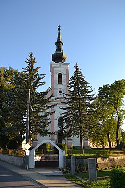
309:
183:
75:
254:
158:
796:
539:
738:
190:
639:
178:
609:
333:
289:
579:
305:
195:
624:
742:
694:
679:
614:
533:
325:
785:
547:
301:
689:
654:
604:
402:"Hustota obyvateľstva - obce [om7014rr_ukaz: Rozloha (Štvorcový meter)]"
684:
664:
649:
485:
503:
Roman
Catholic church records (births/marriages/deaths): 1716-1900 (parish B)
141:
128:
674:
591:
514:
710:
659:
634:
313:
171:
644:
297:
527:
277:
468:(in Slovak). Statistical Office of the Slovak Republic. 2022-03-31
440:(in Slovak). Statistical Office of the Slovak Republic. 2015-04-17
408:(in Slovak). Statistical Office of the Slovak Republic. 2022-03-31
380:(in Slovak). Statistical Office of the Slovak Republic. 2022-03-31
551:
746:
273:
263:
253:
243:
235:
230:
222:
214:
209:
201:
189:
177:
157:
21:
374:"Počet obyvateľov podľa pohlavia - obce (ročne)"
792:Villages and municipalities in Poltár District
766:
563:
8:
354:List of municipalities and towns in Slovakia
486:http://www.hrnciarskezaluzany.sk/index.html
428:
426:
424:
422:
110:Location of Hrnčiarske Zalužany in Slovakia
97:
61:
773:
759:
570:
556:
548:
532:
18:
328:in 1918, Hrnčiarske Zalužany was part of
336:. From 1939 to 1945, it was part of the
324:Before the establishment of independent
543:of living people in Hrnciarske Zaluzany
365:
272:
262:
242:
229:
221:
208:
200:
156:
121:
74:Location of Hrnčiarske Zalužany in the
46:
34:
802:Banská Bystrica Region geography stubs
396:
394:
252:
234:
213:
188:
176:
7:
724:
722:
456:
454:
218:6.09 km (2.35 sq mi)
745:. You can help Knowledge (XXG) by
80:Show map of Banská Bystrica Region
14:
726:
709:
513:
164:
96:
89:
60:
53:
36:
1:
462:"Hustota obyvateľstva - obce"
818:
721:
434:"Základná charakteristika"
706:
586:
278:www.hrnciarskezaluzany.sk
122:
47:
35:
28:
330:Gömör and Kishont County
226:223 m (732 ft)
42:Church of the Assumption
16:Municipality in Slovakia
736:Banská Bystrica Region
495:Genealogical resources
310:Banská Bystrica Region
293:
76:Banská Bystrica Region
640:Kokava nad Rimavicou
522:at Wikimedia Commons
113:Show map of Slovakia
630:Hrnčiarske Zalužany
520:Hrnčiarske Zalužany
286:Hrnčiarske Zalužany
138: /
104:Hrnčiarske Zalužany
68:Hrnčiarske Zalužany
23:Hrnčiarske Zalužany
578:Municipalities of
334:Kingdom of Hungary
236: • Total
215: • Total
754:
753:
719:
718:
518:Media related to
466:www.statistics.sk
438:www.statistics.sk
406:www.statistics.sk
378:www.statistics.sk
294:Fazekaszsaluzsány
283:
282:
142:48.400°N 19.867°E
809:
775:
768:
761:
730:
723:
714:
713:
572:
565:
558:
549:
536:
531:
530:
528:Official website
517:
488:
483:
477:
476:
474:
473:
458:
449:
448:
446:
445:
430:
417:
416:
414:
413:
398:
389:
388:
386:
385:
370:
170:
168:
167:
153:
152:
150:
149:
148:
143:
139:
136:
135:
134:
131:
114:
100:
99:
93:
81:
64:
63:
57:
40:
19:
817:
816:
812:
811:
810:
808:
807:
806:
782:
781:
780:
779:
720:
715:
708:
704:
582:
580:Poltár District
576:
526:
525:
510:
497:
492:
491:
484:
480:
471:
469:
460:
459:
452:
443:
441:
432:
431:
420:
411:
409:
400:
399:
392:
383:
381:
372:
371:
367:
362:
350:
338:Slovak Republic
322:
306:Poltár District
249:
202:First mentioned
184:Banská Bystrica
165:
163:
146:
144:
140:
137:
132:
129:
127:
125:
124:
118:
117:
116:
115:
112:
111:
108:
107:
106:
105:
101:
84:
83:
82:
79:
78:
72:
71:
70:
69:
65:
43:
31:
24:
17:
12:
11:
5:
815:
813:
805:
804:
799:
797:Gemer (region)
794:
784:
783:
778:
777:
770:
763:
755:
752:
751:
731:
717:
716:
707:
705:
703:
702:
697:
692:
687:
682:
677:
672:
667:
662:
657:
652:
647:
642:
637:
632:
627:
625:Hrnčiarska Ves
622:
617:
612:
607:
602:
596:
595:
587:
584:
583:
577:
575:
574:
567:
560:
552:
546:
545:
537:
523:
509:
508:External links
506:
505:
504:
496:
493:
490:
489:
478:
450:
418:
390:
364:
363:
361:
358:
357:
356:
349:
346:
326:Czechoslovakia
321:
318:
281:
280:
275:
271:
270:
267:
261:
260:
257:
251:
250:
247:
245:
241:
240:
237:
233:
232:
228:
227:
224:
220:
219:
216:
212:
211:
207:
206:
203:
199:
198:
193:
187:
186:
181:
175:
174:
161:
155:
154:
147:48.400; 19.867
120:
119:
109:
103:
102:
95:
94:
88:
87:
86:
85:
73:
67:
66:
59:
58:
52:
51:
50:
49:
48:
45:
44:
41:
33:
32:
29:
26:
25:
22:
15:
13:
10:
9:
6:
4:
3:
2:
814:
803:
800:
798:
795:
793:
790:
789:
787:
776:
771:
769:
764:
762:
757:
756:
750:
748:
744:
741:article is a
740:
737:
732:
729:
725:
712:
701:
698:
696:
693:
691:
688:
686:
683:
681:
678:
676:
673:
671:
668:
666:
663:
661:
658:
656:
653:
651:
648:
646:
643:
641:
638:
636:
633:
631:
628:
626:
623:
621:
618:
616:
613:
611:
610:České Brezovo
608:
606:
603:
601:
598:
597:
594:
593:
589:
588:
585:
581:
573:
568:
566:
561:
559:
554:
553:
550:
544:
542:
538:
535:
529:
524:
521:
516:
512:
511:
507:
502:
501:
500:
494:
487:
482:
479:
467:
463:
457:
455:
451:
439:
435:
429:
427:
425:
423:
419:
407:
403:
397:
395:
391:
379:
375:
369:
366:
359:
355:
352:
351:
347:
345:
341:
339:
335:
331:
327:
319:
317:
315:
311:
307:
303:
299:
295:
291:
287:
279:
276:
268:
266:
258:
256:
246:
238:
225:
217:
204:
197:
194:
192:
185:
182:
180:
173:
162:
160:
151:
123:Coordinates:
92:
77:
56:
39:
27:
20:
747:expanding it
733:
629:
590:
540:
498:
481:
470:. Retrieved
465:
442:. Retrieved
437:
410:. Retrieved
405:
382:. Retrieved
377:
368:
342:
323:
302:municipality
285:
284:
259:+421 47
30:Municipality
332:within the
248:980 12
244:Postal code
145: /
786:Categories
472:2022-03-31
444:2022-03-31
412:2022-03-31
384:2022-03-31
360:References
231:Population
739:geography
695:Veľká Ves
600:Breznička
290:Hungarian
265:Car plate
255:Area code
223:Elevation
680:Šoltýska
655:Mládzovo
635:Kalinovo
620:Hradište
615:Ďubákovo
605:Cinobaňa
541:Surnames
348:See also
314:Slovakia
191:District
172:Slovakia
685:Uhorské
665:Rovňany
650:Málinec
320:History
308:in the
304:in the
298:village
296:) is a
274:Website
159:Country
133:19°52′E
130:48°24′N
700:Zlatno
690:Utekáč
675:Sušany
592:Poltár
196:Poltár
179:Region
169:
734:This
670:Selce
660:Ozdín
743:stub
645:Krná
300:and
210:Area
205:1362
312:of
239:828
788::
464:.
453:^
436:.
421:^
404:.
393:^
376:.
340:.
316:.
292::
269:PT
774:e
767:t
760:v
749:.
571:e
564:t
557:v
475:.
447:.
415:.
387:.
288:(
Text is available under the Creative Commons Attribution-ShareAlike License. Additional terms may apply.