40:
289:
57:
87:
94:
64:
311:
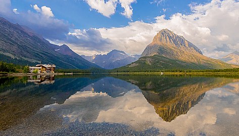
255:, the largest hotel in the park, is along the east shore of the lake. Many hiking trails originate from the area and scenic tour boats provide access to the lake for visitors.
288:
429:
56:
282:
are the largest mountains immediately west of the lake. It consists of two basins, each between 15 feet (4.6 m) and 30 feet (9.1 m) in depth.
434:
86:
355:
321:
142:
266:
to the immediate southwest. The mountains immediately west of the lake rise 3,000 feet (910 m) above the lake. The fast disappearing
346:
351:
378:
240:
119:
315:
263:
39:
341:
123:
279:
258:
Swiftcurrent Lake lies at 4,878 feet (1,487 m) above sea level. Nearby lakes include the much larger
271:
270:
is one of several glaciers and snowfields that provide water for the streams that replenish the lake.
295:
252:
267:
275:
259:
184:
402:
423:
174:
128:
236:
244:
157:
144:
17:
310:
248:
222:
214:
206:
198:
194:
183:
173:
134:
115:
32:
135:
8:
373:
371:
44:Swiftcurrent Lake in Glacier National Park
29:
93:
63:
356:United States Department of the Interior
322:List of lakes in Glacier County, Montana
333:
284:
430:Lakes of Glacier National Park (U.S.)
7:
347:Geographic Names Information System
25:
403:"Swiftcurrent Lake, Montana, USA"
435:Lakes of Glacier County, Montana
309:
287:
92:
85:
62:
55:
38:
352:United States Geological Survey
221:
213:
205:
197:
27:Lake in Glacier County, Montana
1:
114:
106:Show map of the United States
226:4,878 ft (1,487 m)
120:Glacier National Park (U.S.)
451:
210:.5 mi (0.80 km)
49:
37:
218:30 ft (9.1 m)
202:1 mi (1.6 km)
124:Glacier County, Montana
158:48.79528°N 113.66139°W
241:Glacier National Park
318:at Wikimedia Commons
163:48.79528; -113.66139
342:"Swiftcurrent Lake"
154: /
76:Show map of Montana
379:"Many Glacier, MT"
296:Many Glacier Hotel
253:Many Glacier Hotel
235:is located in the
405:. lakelubbers.com
382:(Map (USGS Quad))
316:Swiftcurrent Lake
314:Media related to
233:Swiftcurrent Lake
230:
229:
223:Surface elevation
100:Swiftcurrent Lake
70:Swiftcurrent Lake
33:Swiftcurrent Lake
16:(Redirected from
442:
414:
413:
411:
410:
399:
393:
392:
390:
389:
383:
375:
366:
365:
363:
362:
338:
313:
291:
268:Grinnell Glacier
262:to the east and
169:
168:
166:
165:
164:
159:
155:
152:
151:
150:
147:
137:
107:
96:
95:
89:
77:
66:
65:
59:
42:
30:
21:
450:
449:
445:
444:
443:
441:
440:
439:
420:
419:
418:
417:
408:
406:
401:
400:
396:
387:
385:
381:
377:
376:
369:
360:
358:
340:
339:
335:
330:
306:
299:
292:
187: countries
162:
160:
156:
153:
148:
145:
143:
141:
140:
127:
111:
110:
109:
108:
105:
104:
103:
102:
101:
97:
80:
79:
78:
75:
74:
73:
72:
71:
67:
45:
28:
23:
22:
15:
12:
11:
5:
448:
446:
438:
437:
432:
422:
421:
416:
415:
394:
367:
332:
331:
329:
326:
325:
324:
319:
305:
302:
301:
300:
293:
286:
276:Grinnell Point
264:Lake Josephine
260:Lake Sherburne
228:
227:
224:
220:
219:
216:
212:
211:
208:
204:
203:
200:
196:
195:
192:
191:
188:
181:
180:
177:
171:
170:
138:
132:
131:
117:
113:
112:
99:
98:
91:
90:
84:
83:
82:
81:
69:
68:
61:
60:
54:
53:
52:
51:
50:
47:
46:
43:
35:
34:
26:
24:
14:
13:
10:
9:
6:
4:
3:
2:
447:
436:
433:
431:
428:
427:
425:
404:
398:
395:
380:
374:
372:
368:
357:
353:
349:
348:
343:
337:
334:
327:
323:
320:
317:
312:
308:
307:
303:
297:
290:
285:
283:
281:
277:
273:
269:
265:
261:
256:
254:
250:
246:
242:
238:
234:
225:
217:
209:
201:
193:
190:United States
189:
186:
182:
178:
176:
172:
167:
139:
133:
130:
129:United States
125:
121:
118:
88:
58:
48:
41:
36:
31:
19:
18:Iceberg Notch
407:. Retrieved
397:
386:. Retrieved
359:. Retrieved
345:
336:
280:Mount Wilbur
257:
237:Many Glacier
232:
231:
384:. TopoQuest
298:on the left
272:Mount Gould
199:Max. length
161: /
149:113°39′41″W
136:Coordinates
424:Categories
409:2021-09-10
388:2011-01-30
361:2011-01-30
328:References
294:Lake with
245:U.S. state
239:region of
215:Max. depth
207:Max. width
146:48°47′43″N
243:, in the
304:See also
116:Location
251:. The
249:Montana
179:Natural
185:Basin
278:and
175:Type
247:of
426::
370:^
354:,
350:.
344:.
274:,
122:,
412:.
391:.
364:.
126:,
20:)
Text is available under the Creative Commons Attribution-ShareAlike License. Additional terms may apply.