52:
365:
432:
440:
376:
59:
424:
29:
263:
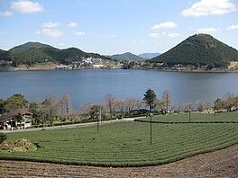
Imuta-ike is surrounded by mountains; Funamidake (498.8 metres (1,636 ft)), San-o-dake (491 metres (1,611 ft)), Katagi-yama (508.8 metres (1,669 ft)), Tōmigashiro (477 metres (1,565 ft)), Ī-moriyama (432 metres (1,417 ft), known due to its beauty also as Imuta-fuji), and
458:
244:
415:
mats. In autumn, villagers used to cut and bundle rushes. Between 1741 and 1763, a 380-meter tunnel water lane was made at the eastern end of the pond, and 15 hectares of rice fields were made. In 1953, Imuta-ike was made a
264:
there is no incoming large river. The outgoing water flows into Sendai River and Hiwagi River. Imuta-ike is in the last stage of the lake-pond formation cycle and is shrinking with the deposition of
51:
276:
is 6.8; the water of the pond contains organic substances. There are many cherry trees around the pond. About one third of its area, to the northwest, is wetland; dotted by
627:
632:
535:
94:
592:
240:
506:
637:
622:
453:
285:
563:
394:, 4 km from east to west and 7 km from north to south. The centre of the domes was depressed forming a
417:
364:
358:
337:
607:
528:
368:
236:
80:
34:
379:
353:
588:
483:
179:
459:
List of
Special Places of Scenic Beauty, Special Historic Sites and Special Natural Monuments
398:. The lava dome formed Iimori-yama. The depression collected water and Imuta-ike was formed.
277:
559:
431:
343:
269:
407:
616:
402:
312:
232:
126:
316:
228:
131:
252:
38:
439:
391:
375:
332:
297:
225:
109:
96:
301:
288:
a
Natural Monument as the "peat forming vegetation of Imuta-ike" in 1921.
306:
265:
248:
423:
395:
348:
412:
28:
478:
438:
430:
422:
405:(1912–1926), Imuta-ike was known for the growth of common rushes (
363:
281:
562:[Imuta-ike Peatland Plant Communities] (in Japanese).
390:
Between 300,000 and 400,000 years ago, there were groups of
273:
161:
0.0005 cubic kilometres (18,000,000 cu ft)
284:. This is very rare in warm areas and the pond was
194:
186:
177:
173:
165:
157:
149:
141:
137:
125:
86:
76:
21:
87:
357:is found, leading to the pond's selection as a
324:
217:
268:. The colour of the pond is brown, 14 on the
8:
243:. Its plant communities were designated a
18:
374:
554:
552:
470:
304:grow thick and in the water, there are
193:
185:
176:
7:
16:Caldera lake in Kagoshima Prefecture
145:0.63 square kilometres (63 ha)
587:2004, University of Nagoya Press ,
529:"Ramsar Sites in Japan – Imutaike"
507:"The Annotated Ramsar List: Japan"
14:
241:Imutaike Prefectural Natural Park
58:
315:. As for fish, species include
57:
50:
27:
164:
156:
148:
140:
247:in 1921 and sixty hectares of
1:
628:Lakes of Kagoshima Prefecture
454:List of Ramsar sites in Japan
75:
296:On the surface of the pond,
564:Agency for Cultural Affairs
536:Ministry of the Environment
654:
633:Natural monuments of Japan
239:, Japan. It forms part of
486:Sites Information Service
325:
245:Natural Monument of Japan
218:
206:
202:
45:
26:
418:Prefectural Natural Park
411:), the raw material for
169:295 metres (968 ft)
153:2.7 metres (8.9 ft)
435:Aerial photograph, 1974
427:Peat forming vegetation
444:
436:
428:
382:
372:
638:Volcanic crater lakes
623:Ramsar sites in Japan
608:Imuta-ike Ramsar Site
442:
434:
426:
378:
367:
338:Carassius langsdorfii
369:Sinanodonta woodiana
309:, nymphaea tetragona
237:Kagoshima Prefecture
81:Kagoshima Prefecture
35:Kagoshima Prefecture
106: /
585:Nihon Koshoushi 2
445:
437:
429:
383:
380:Libellula angelina
373:
354:Libellula angelina
251:were designated a
195:Reference no.
110:31.817°N 130.467°E
210:
209:
166:Surface elevation
645:
595:
581:
575:
574:
572:
570:
556:
547:
546:
544:
542:
533:
525:
519:
518:
516:
514:
503:
497:
496:
494:
492:
475:
330:
328:
327:
278:floating islands
223:
221:
220:
121:
120:
118:
117:
116:
111:
107:
104:
103:
102:
99:
89:
61:
60:
54:
31:
19:
653:
652:
648:
647:
646:
644:
643:
642:
613:
612:
604:
599:
598:
583:Masaaki Tanaka
582:
578:
568:
566:
560:"藺牟田池の泥炭形成植物群落"
558:
557:
550:
540:
538:
531:
527:
526:
522:
512:
510:
505:
504:
500:
490:
488:
477:
476:
472:
467:
450:
388:
344:Oryzias latipes
322:
294:
270:Forel-Ule scale
261:
215:
190:8 November 2005
182:
115:31.817; 130.467
114:
112:
108:
105:
100:
97:
95:
93:
92:
72:
71:
70:
69:
68:
67:
66:
62:
41:
17:
12:
11:
5:
651:
649:
641:
640:
635:
630:
625:
615:
614:
611:
610:
603:
602:External links
600:
597:
596:
576:
548:
520:
498:
469:
468:
466:
463:
462:
461:
456:
449:
446:
408:Juncus effusus
387:
384:
318:Zacco platypus
293:
290:
260:
257:
208:
207:
204:
203:
200:
199:
196:
192:
191:
188:
184:
183:
180:Ramsar Wetland
178:
175:
174:
171:
170:
167:
163:
162:
159:
155:
154:
151:
147:
146:
143:
139:
138:
135:
134:
129:
123:
122:
90:
84:
83:
78:
74:
73:
64:
63:
56:
55:
49:
48:
47:
46:
43:
42:
32:
24:
23:
15:
13:
10:
9:
6:
4:
3:
2:
650:
639:
636:
634:
631:
629:
626:
624:
621:
620:
618:
609:
606:
605:
601:
594:
593:4-8158-0492-3
590:
586:
580:
577:
565:
561:
555:
553:
549:
537:
530:
524:
521:
508:
502:
499:
487:
485:
480:
474:
471:
464:
460:
457:
455:
452:
451:
447:
443:Imuta volcano
441:
433:
425:
421:
419:
414:
410:
409:
404:
401:Prior to the
399:
397:
393:
385:
381:
377:
370:
366:
362:
360:
356:
355:
350:
346:
345:
340:
339:
334:
320:
319:
314:
313:water caltrop
310:
308:
303:
299:
291:
289:
287:
283:
279:
275:
271:
267:
258:
256:
254:
250:
246:
242:
238:
234:
233:Satsumasendai
230:
227:
214:
205:
201:
197:
189:
181:
172:
168:
160:
152:
144:
136:
133:
130:
128:
124:
119:
91:
85:
82:
79:
53:
44:
40:
36:
33:Imuta-ike in
30:
25:
20:
584:
579:
567:. Retrieved
539:. Retrieved
523:
511:. Retrieved
501:
489:. Retrieved
482:
473:
406:
400:
389:
371:in Imuta-ike
352:
342:
336:
317:
305:
295:
280:composed of
262:
229:caldera lake
212:
211:
158:Water volume
142:Surface area
132:caldera lake
479:"Imuta-ike"
359:Ramsar Site
253:Ramsar Site
113: /
88:Coordinates
39:Ramsar Site
617:Categories
465:References
403:Taishō era
392:lava domes
333:Black bass
298:phragmites
286:designated
272:, and its
226:freshwater
187:Designated
150:Max. depth
349:dragonfly
347:. A rare
302:wild rice
259:Geography
255:in 2005.
213:Imuta-ike
65:Imuta-ike
22:Imuta-ike
541:24 March
513:24 March
509:. Ramsar
491:25 April
448:See also
307:brasenia
266:sediment
249:wetlands
101:130°28′E
77:Location
569:17 June
396:caldera
386:History
321:(Oikawa
98:31°49′N
591:
484:Ramsar
413:tatami
532:(PDF)
292:Biota
224:is a
589:ISBN
571:2012
543:2011
515:2011
493:2018
341:and
300:and
282:peat
219:藺牟田池
198:1544
127:Type
37:, a
331:),
231:in
619::
551:^
534:.
481:.
420:.
361:.
351:,
335:,
326:追河
311:,
274:pH
235:,
573:.
545:.
517:.
495:.
329:)
323:(
222:)
216:(
Text is available under the Creative Commons Attribution-ShareAlike License. Additional terms may apply.