74:
43:
473:
81:
345:
cadastral reforms, the villages of
Inahashi and Busetsu were established on October 1, 1889. The two villages merged to form the town of Inabu in 1940. Until September 30, 2003, the town was located within
55:
529:
73:
386:
510:
105:
42:
54:
539:
503:
382:
351:
347:
312:
179:
366:
145:
443:
496:
394:
415:
534:
308:
162:
243:
174:
328:
480:
378:
316:
167:
60:
324:
154:
150:
358:
523:
390:
192:
374:
370:
362:
342:
277:
335:
239:
120:
107:
472:
234:
350:, but from October 1, 2003 to March 31, 2005, the town was located within
267:
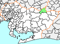
320:
431:平成17年4月1日に旧藤岡町、小原村、足助町、下山村、旭町、稲武町(旧6町村)が合併し、現在の豊田市になりました。
484:
273:
263:
233:
225:
217:
212:
204:
199:
185:
173:
161:
144:
136:
21:
357:On April 1, 2005, Inabu, along with the town of
300:
315:, in the mountainous section of north-central
294:
504:
8:
530:Dissolved municipalities of Aichi Prefecture
479:This Aichi Prefecture location article is a
393:, and has ceased to exist as an independent
338:of 2,928. Its total area was 98.36 km.
511:
497:
18:
406:
258:
232:
211:
198:
135:
100:
66:
51:
39:
334:As of the 2005 census the town had a
272:
262:
224:
216:
208:98.36 km (37.98 sq mi)
203:
184:
172:
160:
143:
7:
469:
467:
16:Former municipality in Chūbu, Japan
483:. You can help Knowledge (XXG) by
14:
471:
79:
72:
53:
41:
1:
80:
448:Aichi Prefectural Government
301:
556:
466:
389:into the expanded city of
121:35.2159889°N 137.5089056°E
295:
283:
259:
254:
250:
101:
67:
52:
40:
33:
25:
126:35.2159889; 137.5089056
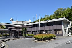
47:former Inabu town hall
540:Aichi geography stubs
377:, and the village of
229:30/km (80/sq mi)
59:Location of Inabu in
383:Higashikamo District
352:Higashikamo District
348:Kitashitara District
313:Higashikamo District
226: • Density
117: /
35:Former municipality
367:Nishikamo District
218: • Total
205: • Total
492:
491:
444:"愛知県の市町村合併 - 愛知県"
416:"山村地域移住情報バンク|豊田市"
361:, the village of
341:During the early
329:Nagano Prefecture
287:
286:
93:Location in Japan
547:
513:
506:
499:
475:
468:
458:
457:
455:
454:
440:
434:
433:
428:
427:
411:
369:), the towns of
317:Aichi Prefecture
306:
304:
298:
297:
168:Aichi Prefecture
132:
131:
129:
128:
127:
122:
118:
115:
114:
113:
110:
83:
82:
76:
61:Aichi Prefecture
57:
45:
28:
19:
555:
554:
550:
549:
548:
546:
545:
544:
520:
519:
518:
517:
464:
462:
461:
452:
450:
442:
441:
437:
425:
423:
413:
412:
408:
403:
325:Gifu Prefecture
292:
190:
125:
123:
119:
116:
111:
108:
106:
104:
103:
97:
96:
95:
94:
91:
90:
89:
88:
84:
63:
48:
36:
29:
26:
24:
17:
12:
11:
5:
553:
551:
543:
542:
537:
532:
522:
521:
516:
515:
508:
501:
493:
490:
489:
476:
460:
459:
435:
405:
404:
402:
399:
285:
284:
281:
280:
275:
271:
270:
265:
261:
260:
257:
256:
252:
251:
248:
247:
237:
231:
230:
227:
223:
222:
219:
215:
214:
210:
209:
206:
202:
201:
197:
196:
187:
183:
182:
177:
171:
170:
165:
159:
158:
148:
142:
141:
138:
134:
133:
112:137°30′32.06″E
99:
98:
92:
86:
85:
78:
77:
71:
70:
69:
68:
65:
64:
58:
50:
49:
46:
38:
37:
34:
31:
30:
22:
15:
13:
10:
9:
6:
4:
3:
2:
552:
541:
538:
536:
535:Toyota, Aichi
533:
531:
528:
527:
525:
514:
509:
507:
502:
500:
495:
494:
488:
486:
482:
477:
474:
470:
465:
449:
445:
439:
436:
432:
422:(in Japanese)
421:
417:
410:
407:
400:
398:
396:
392:
388:
384:
380:
376:
372:
368:
364:
360:
355:
353:
349:
344:
339:
337:
332:
330:
326:
322:
318:
314:
310:
303:
291:
282:
279:
276:
269:
266:
253:
249:
245:
241:
238:
236:
228:
220:
207:
194:
191:(now part of
189:April 1, 2005
188:
181:
178:
176:
169:
166:
164:
156:
152:
149:
147:
139:
130:
109:35°12′57.56″N
102:Coordinates:
75:
62:
56:
44:
32:
20:
485:expanding it
478:
463:
451:. Retrieved
447:
438:
430:
424:. Retrieved
419:
409:
395:municipality
356:
343:Meiji period
340:
333:
323:, bordering
289:
288:
420:Toyota City
365:(both from
311:located in
278:Cryptomeria
180:Higashikamo
124: /
524:Categories
453:2024-02-07
426:2024-02-07
401:References
387:was merged
381:(all from
336:population
213:Population
163:Prefecture
379:Shimoyama
302:Inabu-chō
240:UTC+09:00
235:Time zone
175:District
359:Fujioka
255:Symbols
137:Country
391:Toyota
307:was a
268:Azalea
264:Flower
193:Toyota
186:Merged
146:Region
414:豊田市.
375:Asahi
371:Asuke
363:Obara
321:Japan
290:Inabu
221:2,928
155:Tōkai
151:Chūbu
140:Japan
87:Inabu
23:Inabu
481:stub
373:and
327:and
309:town
274:Tree
200:Area
385:),
296:稲武町
244:JST
27:稲武町
526::
446:.
429:.
418:.
397:.
354:.
331:.
319:,
299:,
512:e
505:t
498:v
487:.
456:.
305:)
293:(
246:)
242:(
195:)
157:)
153:(
Text is available under the Creative Commons Attribution-ShareAlike License. Additional terms may apply.