246:
222:
707:
190:
31:
237:
and on to Pecca Falls, Pecca Twin Falls, Holly Bush Spout and
Thornton Force. A footbridge bridge crosses the Twiss and leads on to Twistleton Lane, which crosses out of the valley of the River Twiss at 285 metres (934 ft). Following Twistleton Lane down past
261:
and flows gently until it reaches the waterfalls walk at
Beezley's Falls Triple Spout (with its three waterfalls side-by side). As the trail continues, you look down 18 metres (59 feet) onto Rival Falls and then onto Baxenghyll
160:
and other newspapers about the scenery in and around
Ingleton, public interest led to the creation of the trail in an area which was previously hidden from view. Paths and bridges were built and the trail opened on
140:, now maintained by the Ingleton Scenery Company. It is claimed that the trail, some 8 kilometres (5 mi) long, and with a vertical rise of 169 m (554 feet) has some of the most spectacular
463:
595:
522:
740:
304:
779:
784:
588:
419:
394:
284:
166:
471:
631:
581:
113:
129:
68:
52:
789:
435:
245:
529:
706:
494:
568:
221:
721:
198:
270:
210:
415:
390:
287:(SSSI) due to the interesting plants and animals and the geological structures located there.
686:
387:
Yorkshire
Landscapes : a photographic tour of England's largest and most varied county
696:
641:
137:
661:
681:
676:
616:
352:
280:
258:
148:
scenery in the north of
England. It is on private land and an entrance fee is charged.
331:
773:
671:
656:
626:
202:
666:
651:
646:
636:
229:
Starting in the
Broadwood car park the trail takes walkers along the banks of the
726:
230:
169:
played a major role in the early success of the trail, attracting visitors from
162:
274:
206:
174:
755:
742:
412:
Yorkshire Dales : local, characterful guides to
Britain's special places
283:
designated the River Twiss and River Doe areas of the
Waterfalls Trail as a
266:, Snow Falls and finally walk through Twistleton Glen and back to Ingleton.
254:
234:
141:
63:
30:
553:
573:
189:
242:
Farm and
Twistleton Hall the walk crosses Oddies Lane to Beezley's Farm.
239:
170:
145:
56:
558:
263:
133:
79:
563:
257:. This river emerges near God's Bridge close to the settlement of
253:
Past
Beezley's the trail starts its descent along the banks of the
193:
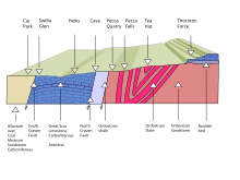
Cross section of the geology of the River Twiss section of the walk
244:
188:
178:
125:
577:
528:. Craven and Pendle Geological Society. Archived from
464:"Taking the plunge – the story behind a stunning walk"
269:
In Ingleton, the Twiss and the Doe meet to form the
714:
609:
109:
101:
93:
85:
75:
62:
48:
40:
23:
305:"The hidden gem that became a tourist hotspot"
589:
8:
414:. Chalfont St Peter: Bradt. pp. 32–33.
569:Detailed Walk description on Car Free Walks
596:
582:
574:
220:
213:rock has been classified as Ordivician.
16:Nature trail in North Yorkshire, England
389:. Oxbow: Windgather Press. p. 44.
296:
128:beginning and ending in the village of
156:Following a number of articles in the
20:
7:
372:
353:"Ingleton Waterfalls Trail: History"
285:Site of Special Scientific Interest
14:
165:, 11 April 1885. The presence of
705:
233:, through Swilla Glenn with its
225:Ingleton Waterfalls Trail symbol
114:Ingleton Scenery Company Limited
29:
495:"Thornton and Twistleton Glens"
470:. 11 April 2008. Archived from
273:, which in turn flows into the
1:
780:Waterfalls of North Yorkshire
785:Footpaths in North Yorkshire
199:North and South Craven fault
523:"Ingleton Waterfalls trail"
436:"Ingleton Waterfalls Trail"
330:Ingleton Waterfalls Trail.
806:
703:
554:Ingleton Waterfalls Trail
124:is a well-known circular
122:Ingleton Waterfalls Trail
69:Ingleton, North Yorkshire
53:Ingleton, North Yorkshire
28:
24:Ingleton Waterfalls Trail
167:Ingleton railway station
89:285 metres (934 ft)
604:Waterfalls of Yorkshire
493:English Nature (1984).
44:8 km (5.0 mi)
410:Bagshaw, Mike (2014).
385:Kennedy, Doug (2017).
332:"History of the Trail"
250:
226:
194:
248:
224:
197:Ingleton lies on the
192:
756:54.15433°N 2.47133°W
443:woodlandtrust.org.uk
752: /
761:54.15433; -2.47133
559:Lancaster Guardian
468:The Yorkshire Post
251:
235:coin embedded tree
227:
195:
158:Lancaster Guardian
735:
734:
421:978-1-84162-549-2
396:978-1-909686-97-7
119:
118:
797:
767:
766:
764:
763:
762:
757:
753:
750:
749:
748:
745:
709:
598:
591:
584:
575:
544:
542:
540:
534:
527:
509:
508:
506:
504:
499:
490:
484:
483:
481:
479:
460:
454:
453:
451:
449:
440:
432:
426:
425:
407:
401:
400:
382:
376:
370:
364:
363:
361:
359:
349:
343:
342:
340:
338:
327:
321:
320:
318:
316:
301:
97:Easy to Moderate
33:
21:
805:
804:
800:
799:
798:
796:
795:
794:
790:Craven District
770:
769:
760:
758:
754:
751:
746:
743:
741:
739:
738:
736:
731:
710:
701:
610:North Yorkshire
605:
602:
564:Natural England
550:
538:
536:
532:
525:
520:
513:
512:
502:
500:
497:
492:
491:
487:
477:
475:
474:on 29 June 2018
462:
461:
457:
447:
445:
438:
434:
433:
429:
422:
409:
408:
404:
397:
384:
383:
379:
371:
367:
357:
355:
351:
350:
346:
336:
334:
329:
328:
324:
314:
312:
303:
302:
298:
293:
219:
187:
154:
138:North Yorkshire
132:in the English
36:
17:
12:
11:
5:
803:
801:
793:
792:
787:
782:
772:
771:
733:
732:
730:
729:
724:
718:
716:
715:West Yorkshire
712:
711:
704:
702:
700:
699:
694:
689:
684:
682:Scaleber Force
679:
674:
669:
664:
659:
654:
649:
644:
639:
634:
632:Cauldron Falls
629:
624:
622:Beezeley Falls
619:
613:
611:
607:
606:
603:
601:
600:
593:
586:
578:
572:
571:
566:
561:
556:
549:
548:External links
546:
535:on 12 May 2013
518:
517:
511:
510:
485:
455:
427:
420:
402:
395:
377:
365:
344:
322:
295:
294:
292:
289:
281:English Nature
259:Chapel-le-Dale
218:
215:
186:
183:
153:
150:
117:
116:
111:
107:
106:
103:
99:
98:
95:
91:
90:
87:
83:
82:
77:
73:
72:
66:
60:
59:
50:
46:
45:
42:
38:
37:
35:Thornton Force
34:
26:
25:
15:
13:
10:
9:
6:
4:
3:
2:
802:
791:
788:
786:
783:
781:
778:
777:
775:
768:
765:
728:
725:
723:
720:
719:
717:
713:
708:
698:
695:
693:
690:
688:
685:
683:
680:
678:
675:
673:
672:Mallyan Spout
670:
668:
665:
663:
660:
658:
655:
653:
650:
648:
645:
643:
640:
638:
635:
633:
630:
628:
625:
623:
620:
618:
615:
614:
612:
608:
599:
594:
592:
587:
585:
580:
579:
576:
570:
567:
565:
562:
560:
557:
555:
552:
551:
547:
545:
531:
524:
521:CPGS (2003).
515:
514:
496:
489:
486:
473:
469:
465:
459:
456:
444:
437:
431:
428:
423:
417:
413:
406:
403:
398:
392:
388:
381:
378:
374:
369:
366:
354:
348:
345:
333:
326:
323:
310:
309:Craven Herald
306:
300:
297:
290:
288:
286:
282:
278:
276:
272:
267:
265:
260:
256:
249:Beezley Falls
247:
243:
241:
236:
232:
223:
216:
214:
212:
208:
204:
203:Carboniferous
200:
191:
184:
182:
180:
176:
172:
168:
164:
159:
151:
149:
147:
143:
139:
135:
131:
127:
123:
115:
112:
110:Maintained by
108:
104:
100:
96:
92:
88:
86:Highest point
84:
81:
78:
74:
70:
67:
65:
61:
58:
54:
51:
47:
43:
39:
32:
27:
22:
19:
737:
691:
662:Janet's Foss
652:Gordale Scar
647:Falling Foss
621:
537:. Retrieved
530:the original
519:
516:Bibliography
501:. Retrieved
488:
476:. Retrieved
472:the original
467:
458:
446:. Retrieved
442:
430:
411:
405:
386:
380:
368:
356:. Retrieved
347:
335:. Retrieved
325:
313:. Retrieved
311:. 1 May 2010
308:
299:
279:
268:
252:
228:
196:
157:
155:
121:
120:
18:
759: /
271:River Greta
231:River Twiss
211:Ingletonian
209:rocks. The
201:, exposing
163:Good Friday
774:Categories
727:Goit Stock
687:Stainforth
291:References
275:River Lune
207:Ordovician
175:Manchester
152:Beginnings
94:Difficulty
71:(circular)
64:Trailheads
747:2°28.28′W
744:54°9.26′N
697:Wain Wath
642:East Gill
373:CPGS 2003
255:River Doe
142:waterfall
692:Thornton
677:Richmond
617:Aysgarth
240:Scar End
217:The walk
171:Bradford
146:woodland
130:Ingleton
105:All year
49:Location
657:Hardraw
627:Catrake
539:5 March
478:18 June
448:18 June
358:16 July
315:18 June
185:Geology
57:England
722:Brontë
667:Kisdon
637:Cotter
503:9 July
418:
393:
337:9 July
134:county
102:Season
80:Hiking
41:Length
533:(PDF)
526:(PDF)
498:(PDF)
439:(PDF)
264:Gorge
179:Leeds
126:trail
541:2014
505:2007
480:2019
450:2019
416:ISBN
391:ISBN
360:2012
339:2007
317:2019
205:and
177:and
144:and
136:of
76:Use
776::
466:.
441:.
307:.
277:.
181:.
173:,
55:,
597:e
590:t
583:v
543:.
507:.
482:.
452:.
424:.
399:.
375:.
362:.
341:.
319:.
Text is available under the Creative Commons Attribution-ShareAlike License. Additional terms may apply.