31:
361:
294:
340:
267:
239:
noted in 1846 that "…as several of the rotten steps gave way under our feet, our position was far from being pleasant. A number of cormorants and other marine birds, too, that had their nests in the crevices of the rock were screaming and wheeling about us at the intrusion." During the gold rush of
310:
in 2014, with a large number of fallen trees. The storm caused widespread damage and led to the closure of parts of the Inland Pack Track for two years. Regeneration can be seen occurring in clearings left from the storm damage. The remaining part of this section of the track includes mature rimus
381:
There is a formed track downstream from the confluence with
Dilemma Creek, on the true left of the Fox River. The track follows the gorge for 2 km, with some climbs around bluffs. There is a river crossing where the route moves to the true right of the Fox River. The route from this point
347:
This 11 kilometres (6.8 mi) section of track follows an old farm road before the route becomes a single track around a swamp in mixed rimu and beech forest. The trail then climbs a ridge between
Bullock Creek and the catchments of the Fox River and then descends to Fossil Creek. The route
322:
in 1995 when a viewing platform above the chasm collapsed, leading to the deaths of 14 people. There is a memorial on the side of the track to those who died. This section of track was renamed the Cave Creek
Memorial Track/Kotihotiho in 2020, as part of the 25 year remembrance of the disaster.
252:
arranged for the construction of the Inland Pack Track in
January-February 1867. The route was not popular with the diggers, because it involved many river crossings, it was difficult to travel along valley floors and proved time-consuming for the diggers and their laden pack horses. The track
351:
After the widespread damage caused by
Cyclone Ita in 2014, the section of the track between Bullock Creek and Fox River was closed for two years, and this led to complaints. It was eventually re-opened in 2016, after the clearance of around 400 fallen trees.
301:
From the junction of the
Pororari River track and the Inland Pack Track, the route continues to the Lower Pororari Swing Bridge, where the shared-use ends. The remaining sections of the Inland Pack Track are for walkers only. The section of track to
372:
is a short side-trip upstream along the bed of the Fox River, from the confluence with
Dilemma Creek. Crossings of the Fox River are required. The Ballroom Overhang is a limestone half-dome shape, formed by erosion at a bend in the river.
326:
From the intersection with the Cave Creek
Memorial Track, the route of the Inland Pack Track follows an old farm road to Bullock Creek. The Bullock Creek road is a 6 kilometres (3.7 mi) long gravel road that provides an exit to
503:
625:
569:
222:
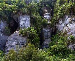
There was no formed road along the
Punakaiki coast until the late 1920s. Early European explorers navigating the coast encountered sheer cliffs at Te Miko, navigable only by climbing ladders totalling 46 feet high (or so
717:
595:
539:
348:
follows Fossil Creek downstream, and there is no formed path. The route then goes along
Dilemma Creek, known for its forested limestone canyon, before meeting the junction of Dilemma Creek with the Fox River.
247:
The cliffs and headlands between Fox River and the Punakaiki River were the greatest obstacles to travel, and many miners died as a result of falls, or from drowning. To mitigate the on-going risks, the
285:
Walkers who take the track down the Pororari River back to Punakaiki from this point will complete the "Punakaiki loop", a round trip of about 11 kilometres (6.8 mi) that takes around 3 hours.
1622:
617:
561:
709:
747:
591:
480:
778:
274:
The trail commences from the south at Waipori Road, where there is a suspension bridge across the Punakaiki River. The section of the trail from the Punakaiki River to the
535:
282:. From the bridge across the Punakaiki River, the track climbs over a low saddle passing through mixed broadleaf forest before dropping into the Pororari River valley.
656:
818:
1283:
1278:
1017:
489:
186:
389:
There is some river bed travel before a forested track section that leads to the Fox River car park at the northern end of the Inland Pack Track.
106:
73:
687:
811:
739:
497:
456:
770:
244:", but the wooden rungs were destroyed by overuse, and travellers slid down the chains instead, or jammed sticks into the links.
1519:
422:
314:
As the track approaches the flat land of the former Bullock Creek Farm, there is a side trail of 4 kilometres (2.5 mi) to
1612:
1544:
804:
1591:
648:
1348:
1010:
328:
1343:
1489:
1338:
1298:
884:
868:
863:
303:
383:
1363:
1464:
1439:
278:
is dual-use – shared between walkers and mountain bikers, and serves as the northern entry or exit point of the
1617:
1499:
1454:
1403:
1076:
1003:
1560:
1459:
1368:
1213:
889:
315:
1479:
1424:
1398:
1182:
1157:
1132:
1061:
914:
30:
1494:
1233:
1177:
1040:
1036:
945:
827:
199:
55:
360:
1534:
232:
1383:
1167:
1142:
984:
319:
1358:
1514:
1429:
1308:
1091:
1086:
894:
211:
36:
679:
293:
1570:
1353:
1303:
1268:
858:
493:
452:
369:
241:
203:
1504:
1106:
462:
224:
1565:
1539:
1509:
1474:
1469:
1328:
1318:
1273:
1152:
1026:
909:
899:
339:
249:
207:
1484:
1388:
1373:
1223:
904:
275:
236:
1606:
1524:
1419:
1378:
1323:
1313:
1258:
1208:
1203:
940:
935:
842:
796:
413:
279:
449:
The Southern Journey: a history of the travelling routes along the coast of Westland
1529:
1444:
1434:
1393:
1293:
1288:
1263:
1066:
952:
1586:
562:"Punakaiki-Pororari Loop: The West Coast track that is one of NZ's best day walks"
1253:
1187:
1172:
307:
266:
995:
1333:
121:
108:
88:
75:
1218:
1162:
968:
466:
62:
1081:
1071:
382:
follows the Fox River Caves Track. These caves were closed following the
228:
1228:
1147:
1137:
1127:
1101:
1111:
1096:
359:
338:
331:
on the coast for those not wanting to complete the full distance.
292:
265:
214:
in the north. It takes two or three days to complete the track.
999:
800:
240:
the 1860s these were replaced by chain ladders, soon known as "
206:
of New Zealand. The full length of the trail commences at the
451:(1st ed.). Christchurch: Mark Pickering. pp. 26–28.
1623:
Hiking and tramping tracks in the West Coast Region
1579:
1553:
1412:
1246:
1196:
1120:
1054:
1047:
977:
961:
923:
877:
851:
835:
182:
165:
157:
140:
61:
51:
43:
23:
412:
649:"West Coast track closure hits local businesses"
386:because of a large rockfall over the entrance.
1284:Blackwater River (Little Grey River tributary)
1011:
812:
8:
442:
440:
318:and the resurgence. This is the site of the
210:in the south, and ends at the mouth of the
1051:
1018:
1004:
996:
819:
805:
797:
740:"Ballroom Overhang, Paparoa National Park"
1279:Blackwater River (Buller River tributary)
771:"DOC huts swept away in earthquake slips"
270:Suspension bridge over the Pororari River
769:van Beynen, Martin (19 November 2016).
398:
618:"Cave Creek Memorial Track/Kotihotiho"
482:Paparoa National Park Resource Summary
20:
781:from the original on 20 February 2021
7:
680:"West Coasters get their track back"
659:from the original on 8 November 2020
530:
528:
526:
524:
406:
404:
402:
572:from the original on 2 January 2021
411:Barnett, Shaun (July–August 2010).
542:from the original on 14 April 2021
509:from the original on 22 March 2022
14:
750:from the original on 26 July 2021
720:from the original on 27 June 2022
628:from the original on 24 June 2022
598:from the original on 24 June 2022
425:from the original on 24 June 2021
262:Punakaiki River to Pororari River
690:from the original on 13 May 2021
678:Arnold, Naomi (19 August 2016).
377:Dilemma Creek to Fox River mouth
253:eventually fell into disrepair.
29:
647:Gudsell, Kate (27 March 2016).
289:Pororari River to Bullock Creek
594:. Department of Conservation.
538:. Department of Conservation.
1:
364:Ballroom overhang – Fox River
1490:Pancake Rocks and Blowholes
1339:Metro Cave / Te Ananui Cave
869:Pancake Rocks and Blowholes
864:Metro Cave / Te Ananui Cave
150:Mountain biking (part only)
35:Limestone cliffs along the
1639:
1413:Facilities and attractions
714:Department of Conservation
622:Department of Conservation
490:Department of Conservation
335:Bullock Creek to Fox River
187:Department of Conservation
16:New Zealand tramping track
1465:Karamea Centennial Museum
1440:Granity Community Library
1034:
710:"Ballroom Overhang Track"
306:was badly damaged during
250:Nelson Provincial Council
103:Fox River mouth car park
28:
1520:Stillwater–Ngākawau Line
1500:Punakaiki Marine Reserve
1455:Kahurangi Marine Reserve
1404:Wharepapa / Arthur Range
384:2016 Kaikōura earthquake
161:198 m (650 ft)
1460:Kahurangi National Park
890:Cave Creek / Kotihotiho
852:Caves and rock features
592:"Pororari River Tracks"
447:Mark Pickering (1993).
316:Cave Creek / Kotihotiho
47:25 km (16 mi)
1480:Ngakawau Hydro Project
1425:Charming Creek Tramway
1399:Waitakere / Nile River
915:Waitakere / Nile River
419:New Zealand Geographic
365:
344:
298:
271:
122:42.03139°S 171.38500°E
89:42.12611°S 171.34556°E
70:Waikori Road car park
1613:Paparoa National Park
1592:Ngāti Apa ki te Rā Tō
1495:Paparoa National Park
946:Pike29 Memorial Track
828:Paparoa National Park
363:
342:
297:Cave Creek resurgence
296:
269:
200:Paparoa National Park
56:Paparoa National Park
1535:Victoria Forest Park
1364:Ōpārara Basin Arches
568:. 28 December 2020.
127:-42.03139; 171.38500
94:-42.12611; 171.34556
1384:Perpendicular Point
1247:Geographic features
985:Cave Creek disaster
744:Wilderness Magazine
684:Wilderness Magazine
536:"Inland Pack Track"
414:"Inland Pack Track"
320:Cave Creek disaster
227:estimated) made of
118: /
85: /
1515:Seddonville Branch
1430:Conns Creek Branch
1087:Inangahua Junction
878:Rivers and streams
366:
345:
299:
272:
198:is a trail in the
37:Fox River (Buller)
1600:
1599:
1450:Inland Pack Track
1369:Ōtūmahana Estuary
1304:Denniston Plateau
1269:Ballroom Overhang
1242:
1241:
993:
992:
931:Inland Pack Track
859:Ballroom Overhang
370:Ballroom Overhang
368:The route to the
356:Ballroom Overhang
196:Inland Pack Track
192:
191:
172:Limestone canyons
24:Inland Pack Track
1630:
1571:Regional Council
1561:District Council
1545:Westport Airport
1505:Reefton Hospital
1107:Springs Junction
1052:
1048:Populated places
1020:
1013:
1006:
997:
821:
814:
807:
798:
791:
790:
788:
786:
766:
760:
759:
757:
755:
736:
730:
729:
727:
725:
706:
700:
699:
697:
695:
675:
669:
668:
666:
664:
644:
638:
637:
635:
633:
614:
608:
607:
605:
603:
588:
582:
581:
579:
577:
558:
552:
551:
549:
547:
532:
519:
518:
516:
514:
508:
487:
477:
471:
470:
444:
435:
434:
432:
430:
416:
408:
311:and many ferns.
133:
132:
130:
129:
128:
123:
119:
116:
115:
114:
111:
100:
99:
97:
96:
95:
90:
86:
83:
82:
81:
78:
33:
21:
1638:
1637:
1633:
1632:
1631:
1629:
1628:
1627:
1618:Buller District
1603:
1602:
1601:
1596:
1575:
1549:
1540:Wangapeka Track
1510:Rockies Incline
1475:Mokihinui Hydro
1470:Koranui Incline
1408:
1329:Lake Christabel
1319:Kahurangi Point
1274:Beautiful River
1238:
1192:
1153:Little Wanganui
1116:
1043:
1030:
1027:Buller District
1024:
994:
989:
973:
957:
919:
910:Punakaiki River
900:Four Mile River
873:
847:
836:Mountain ranges
831:
825:
795:
794:
784:
782:
768:
767:
763:
753:
751:
738:
737:
733:
723:
721:
708:
707:
703:
693:
691:
677:
676:
672:
662:
660:
646:
645:
641:
631:
629:
616:
615:
611:
601:
599:
590:
589:
585:
575:
573:
560:
559:
555:
545:
543:
534:
533:
522:
512:
510:
506:
500:
485:
479:
478:
474:
459:
446:
445:
438:
428:
426:
410:
409:
400:
395:
379:
358:
337:
329:State Highway 6
291:
264:
259:
220:
208:Punakaiki River
178:
153:
136:
126:
124:
120:
117:
112:
109:
107:
105:
104:
93:
91:
87:
84:
79:
76:
74:
72:
71:
39:
17:
12:
11:
5:
1636:
1634:
1626:
1625:
1620:
1615:
1605:
1604:
1598:
1597:
1595:
1594:
1589:
1583:
1581:
1577:
1576:
1574:
1573:
1568:
1563:
1557:
1555:
1551:
1550:
1548:
1547:
1542:
1537:
1532:
1527:
1522:
1517:
1512:
1507:
1502:
1497:
1492:
1487:
1485:Old Ghost Road
1482:
1477:
1472:
1467:
1462:
1457:
1452:
1447:
1442:
1437:
1432:
1427:
1422:
1416:
1414:
1410:
1409:
1407:
1406:
1401:
1396:
1391:
1389:Pororari River
1386:
1381:
1376:
1374:Papahaua Range
1371:
1366:
1361:
1356:
1354:Ngākawau River
1351:
1346:
1344:Mount Augustus
1341:
1336:
1331:
1326:
1321:
1316:
1311:
1306:
1301:
1296:
1291:
1286:
1281:
1276:
1271:
1266:
1261:
1256:
1250:
1248:
1244:
1243:
1240:
1239:
1237:
1236:
1231:
1226:
1224:Sergeants Hill
1221:
1216:
1211:
1206:
1200:
1198:
1194:
1193:
1191:
1190:
1185:
1180:
1175:
1170:
1165:
1160:
1155:
1150:
1145:
1140:
1135:
1130:
1124:
1122:
1118:
1117:
1115:
1114:
1109:
1104:
1099:
1094:
1089:
1084:
1079:
1074:
1069:
1064:
1058:
1056:
1055:Inangahua Ward
1049:
1045:
1044:
1035:
1032:
1031:
1025:
1023:
1022:
1015:
1008:
1000:
991:
990:
988:
987:
981:
979:
975:
974:
972:
971:
965:
963:
959:
958:
956:
955:
950:
949:
948:
943:
933:
927:
925:
924:Walking tracks
921:
920:
918:
917:
912:
907:
905:Pororari River
902:
897:
892:
887:
881:
879:
875:
874:
872:
871:
866:
861:
855:
853:
849:
848:
846:
845:
839:
837:
833:
832:
826:
824:
823:
816:
809:
801:
793:
792:
761:
746:. 5 May 2016.
731:
701:
670:
639:
609:
583:
553:
520:
498:
472:
457:
436:
397:
396:
394:
391:
378:
375:
357:
354:
336:
333:
290:
287:
276:Pororari River
263:
260:
258:
255:
242:Jacob's Ladder
237:Charles Heaphy
219:
216:
190:
189:
184:
180:
179:
177:
176:
173:
169:
167:
163:
162:
159:
155:
154:
152:
151:
148:
144:
142:
138:
137:
135:
134:
101:
67:
65:
59:
58:
53:
49:
48:
45:
41:
40:
34:
26:
25:
15:
13:
10:
9:
6:
4:
3:
2:
1635:
1624:
1621:
1619:
1616:
1614:
1611:
1610:
1608:
1593:
1590:
1588:
1585:
1584:
1582:
1578:
1572:
1569:
1567:
1564:
1562:
1559:
1558:
1556:
1552:
1546:
1543:
1541:
1538:
1536:
1533:
1531:
1528:
1526:
1525:Stockton Mine
1523:
1521:
1518:
1516:
1513:
1511:
1508:
1506:
1503:
1501:
1498:
1496:
1493:
1491:
1488:
1486:
1483:
1481:
1478:
1476:
1473:
1471:
1468:
1466:
1463:
1461:
1458:
1456:
1453:
1451:
1448:
1446:
1443:
1441:
1438:
1436:
1433:
1431:
1428:
1426:
1423:
1421:
1420:Big Rimu Walk
1418:
1417:
1415:
1411:
1405:
1402:
1400:
1397:
1395:
1392:
1390:
1387:
1385:
1382:
1380:
1379:Paparoa Range
1377:
1375:
1372:
1370:
1367:
1365:
1362:
1360:
1359:Ōpārara Basin
1357:
1355:
1352:
1350:
1347:
1345:
1342:
1340:
1337:
1335:
1332:
1330:
1327:
1325:
1324:Karamea Bight
1322:
1320:
1317:
1315:
1314:Glasgow Range
1312:
1310:
1307:
1305:
1302:
1300:
1299:Bullock Creek
1297:
1295:
1292:
1290:
1287:
1285:
1282:
1280:
1277:
1275:
1272:
1270:
1267:
1265:
1262:
1260:
1259:Awakari River
1257:
1255:
1252:
1251:
1249:
1245:
1235:
1232:
1230:
1227:
1225:
1222:
1220:
1217:
1215:
1212:
1210:
1209:Carters Beach
1207:
1205:
1204:Cape Foulwind
1202:
1201:
1199:
1197:Westport Ward
1195:
1189:
1186:
1184:
1181:
1179:
1176:
1174:
1171:
1169:
1166:
1164:
1161:
1159:
1156:
1154:
1151:
1149:
1146:
1144:
1141:
1139:
1136:
1134:
1131:
1129:
1126:
1125:
1123:
1119:
1113:
1110:
1108:
1105:
1103:
1100:
1098:
1095:
1093:
1090:
1088:
1085:
1083:
1080:
1078:
1075:
1073:
1070:
1068:
1065:
1063:
1060:
1059:
1057:
1053:
1050:
1046:
1042:
1038:
1033:
1029:, New Zealand
1028:
1021:
1016:
1014:
1009:
1007:
1002:
1001:
998:
986:
983:
982:
980:
976:
970:
967:
966:
964:
960:
954:
951:
947:
944:
942:
941:Croesus Track
939:
938:
937:
936:Paparoa Track
934:
932:
929:
928:
926:
922:
916:
913:
911:
908:
906:
903:
901:
898:
896:
893:
891:
888:
886:
885:Bullock Creek
883:
882:
880:
876:
870:
867:
865:
862:
860:
857:
856:
854:
850:
844:
843:Paparoa Range
841:
840:
838:
834:
830:, New Zealand
829:
822:
817:
815:
810:
808:
803:
802:
799:
780:
776:
772:
765:
762:
749:
745:
741:
735:
732:
719:
715:
711:
705:
702:
689:
685:
681:
674:
671:
658:
654:
650:
643:
640:
627:
623:
619:
613:
610:
597:
593:
587:
584:
571:
567:
563:
557:
554:
541:
537:
531:
529:
527:
525:
521:
505:
501:
499:0-478-01193-8
495:
491:
484:
483:
476:
473:
468:
464:
460:
458:0-9583289-0-0
454:
450:
443:
441:
437:
424:
420:
415:
407:
405:
403:
399:
392:
390:
387:
385:
376:
374:
371:
362:
355:
353:
349:
343:Dilemma Creek
341:
334:
332:
330:
324:
321:
317:
312:
309:
305:
304:Bullock Creek
295:
288:
286:
283:
281:
280:Paparoa Track
277:
268:
261:
256:
254:
251:
245:
243:
238:
234:
230:
226:
217:
215:
213:
209:
205:
201:
197:
188:
185:
183:Maintained by
181:
174:
171:
170:
168:
164:
160:
158:Highest point
156:
149:
146:
145:
143:
139:
131:
102:
98:
69:
68:
66:
64:
60:
57:
54:
50:
46:
42:
38:
32:
27:
22:
19:
1530:Truman Track
1449:
1445:Heaphy Track
1435:Fenian Track
1394:Scotts Beach
1294:Buller River
1289:Buller Gorge
1264:Awarau River
1067:Blacks Point
953:Truman Track
930:
783:. Retrieved
774:
764:
752:. Retrieved
743:
734:
722:. Retrieved
713:
704:
692:. Retrieved
683:
673:
661:. Retrieved
652:
642:
630:. Retrieved
621:
612:
600:. Retrieved
586:
574:. Retrieved
565:
556:
544:. Retrieved
511:. Retrieved
481:
475:
448:
427:. Retrieved
418:
388:
380:
367:
350:
346:
325:
313:
300:
284:
273:
246:
231:and rotting
221:
195:
193:
175:Dense forest
18:
1349:Mount Haast
1254:Allen River
1188:Waimangaroa
1173:Seddonville
1121:Seddon Ward
1077:Crushington
962:Settlements
308:Cyclone Ita
125: /
113:171°23′06″E
92: /
80:171°20′44″E
1607:Categories
1554:Government
1334:Lewis Pass
1214:Charleston
467:Q112841645
393:References
204:West Coast
110:42°01′53″S
77:42°07′34″S
63:Trailheads
1587:Ngāi Tahu
1309:Fox River
1219:Punakaiki
1183:Summerlea
1163:Mokihinui
1158:Millerton
1133:Denniston
1062:Big River
969:Punakaiki
895:Fox River
513:8 January
233:rātā vine
212:Fox River
1234:Westport
1178:Stockton
1168:Ngakawau
1082:Ikamatua
1072:Cronadun
1041:Westport
779:Archived
748:Archived
718:Archived
688:Archived
657:Archived
626:Archived
596:Archived
570:Archived
540:Archived
504:Archived
492:. 1990.
463:Wikidata
423:Archived
229:harakeke
147:Tramping
52:Location
1229:Te Kuha
1148:Karamea
1138:Granity
1128:Arapito
1102:Reefton
694:30 June
421:(104).
218:History
1143:Hector
1112:Waiuta
1097:Maruia
978:Events
785:3 July
754:2 July
724:2 July
663:3 July
632:2 July
602:2 July
576:2 July
546:2 July
496:
465:
455:
429:2 July
166:Sights
44:Length
1566:Mayor
1092:Lyell
775:Stuff
566:Stuff
507:(PDF)
486:(PDF)
257:Route
225:Haast
1037:Seat
787:2022
756:2022
726:2022
696:2022
665:2022
634:2022
604:2022
578:2022
548:2022
515:2012
494:ISBN
453:ISBN
431:2022
194:The
1580:Iwi
653:RNZ
202:on
141:Use
1609::
1039::
777:.
773:.
742:.
716:.
712:.
686:.
682:.
655:.
651:.
624:.
620:.
564:.
523:^
502:.
488:.
461:.
439:^
417:.
401:^
235:.
1019:e
1012:t
1005:v
820:e
813:t
806:v
789:.
758:.
728:.
698:.
667:.
636:.
606:.
580:.
550:.
517:.
469:.
433:.
Text is available under the Creative Commons Attribution-ShareAlike License. Additional terms may apply.