50:
81:
421:
33:
399:
649:
88:
57:
632:
49:
554:
80:
604:// Ecology and geography of plants and plant communities: Proceedings of the IV International Scientific Conference. - Yekaterinburg, 2018. - April 16. — ISBN 978-5-7741-0341-6
589:Отчет о геологической съемке масштаба 1:50000 и поисках месторождений полезных ископаемых в бассейне нижнего течения р. Иомраутваам на территории листов Р-60-38-В,
669:
391:. It was found during an expedition to Chukotka in the summer of 2011 buried in a 7,000-year-old layer of dirt and was named Khatyrka meteorite.
207:
565:
633:
The
Penzhina-West Kamchatka folded zone and the Ukelayat-Sredinnyi block in the structure of the Koryak Highland and Kamchatka
623:
Collisions in outer space produced an icosahedral phase in the
Khatyrka meteorite never observed previously in the laboratory
340:. It flows in a roughly northeastern direction in the northern section of the range. Finally it meets the right bank of the
363:
639:
674:
306:
128:
65:
471:
617:
627:
602:
Vegetation cover of the North of the
Kamchatka Okrug (Kamchatsky Krai) and its geobotanical zoning
424:
Members of the 2011 expedition that visited the
Iomrautvaam area and found the Khatyrka meteorite.
353:
511:
333:
167:
341:
337:
321:
290:
273:
193:
32:
420:
298:
138:
123:
344:
100 kilometres (62 mi) from its mouth, close to the northeastern end of the ridge.
314:
663:
653:
543:
618:
Astronomy.com - An old meteor yields a new surprise: a never-before-seen material
523:
188:
491:
466:
398:
277:
378:
365:
222:
209:
622:
492:"Река Иомраутваам (Емрауткенваам) in the State Water Register of Russia"
450:
357:
313:. The length of the river is 103 kilometres (64 mi) and the area of is
576:
446:
438:
310:
116:
454:
524:"Топографска карта P-59_60 - Topographic USSR Chart (in Russian)"
442:
566:
Cosmic sleuthing: An origin story for a really weird meteorite
402:
High-resolution electron-microscopy image of natural Al
637:
628:
Khatyrka meteorite found to have third quasicrystal
360:fell in the area of the Iomrautvaam river basin at
269:
264:
256:
248:
238:
199:
187:
173:
161:
153:
144:
134:
122:
112:
107:
21:
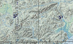
320:The Iomrautvaam is the longest tributary of the
317:1,310 square kilometres (510 sq mi).
587:Звизда Т. В., Мануйлов А. А., Василенко А. М.
414:quasicrystal found in the Khatyrka meteorite.
8:
577:Khatyrka meteorite, Iomrautvaam - Mindat.org
37:Course of the Iomrautvaam in the upper right
95:Iomrautvaam (Far Eastern Federal District)
419:
397:
98:Show map of Far Eastern Federal District
644:
483:
332:The Iomrautvaam has its source in the
18:
507:
505:
70:Show map of Chukotka Autonomous Okrug
7:
437:The river basin is characterized by
670:Rivers of Chukotka Autonomous Okrug
260:1,310 km (510 sq mi)
87:
56:
14:
647:
86:
79:
55:
48:
31:
591:Г; 39-В. Анадырь, 1977. 221 с.
201: • coordinates
1:
179:ca 700 metres (2,300 ft)
145:Physical characteristics
16:River in the Russian Far East
240: • elevation
175: • elevation
163: • location
25:Иомраутваам / Емрауткенваам
691:
395:
302:
555:Water of Russia - Хатырка
307:Chukotka Autonomous Okrug
294:
183:
149:
129:Chukotka Autonomous Okrug
42:
30:
472:List of rivers of Russia
252:103 km (64 mi)
244:60 metres (200 ft)
441:vegetation, including
425:
415:
379:62.65306°N 174.50056°E
223:62.69056°N 174.86250°E
423:
401:
600:V. Yu. Neshataeva,
384:62.65306; 174.50056
375: /
356:, a unique-type of
265:Basin features
228:62.69056; 174.86250
219: /
426:
416:
354:Khatyrka meteorite
348:Khatyrka meteorite
64:Mouth location in
430:
429:
334:Komeutyuyam Range
283:
282:
168:Komeutyuyam Range
682:
675:Koryak Mountains
652:
651:
650:
643:
605:
598:
592:
585:
579:
574:
568:
563:
557:
552:
546:
541:
535:
534:
532:
530:
520:
514:
509:
500:
499:
488:
394:
393:
390:
389:
387:
386:
385:
380:
376:
373:
372:
371:
368:
338:Koryak Highlands
305:) is a river in
304:
296:
234:
233:
231:
230:
229:
224:
220:
217:
216:
215:
212:
176:
164:
99:
90:
89:
83:
71:
59:
58:
52:
35:
19:
690:
689:
685:
684:
683:
681:
680:
679:
660:
659:
658:
648:
646:
638:
614:
609:
608:
599:
595:
586:
582:
575:
571:
564:
560:
553:
549:
542:
538:
528:
526:
522:
521:
517:
512:Atlas of Russia
510:
503:
490:
489:
485:
480:
463:
435:
433:Flora and fauna
413:
409:
405:
383:
381:
377:
374:
369:
366:
364:
362:
361:
350:
330:
241:
227:
225:
221:
218:
213:
210:
208:
206:
205:
202:
174:
162:
139:Anadyr District
124:Federal subject
103:
102:
101:
100:
97:
96:
93:
92:
91:
74:
73:
72:
69:
68:
62:
61:
60:
38:
26:
23:
17:
12:
11:
5:
688:
686:
678:
677:
672:
662:
661:
657:
656:
636:
635:
630:
625:
620:
613:
612:External links
610:
607:
606:
593:
580:
569:
558:
547:
536:
515:
501:
482:
481:
479:
476:
475:
474:
469:
462:
459:
434:
431:
428:
427:
417:
411:
407:
403:
349:
346:
329:
326:
315:drainage basin
281:
280:
271:
267:
266:
262:
261:
258:
254:
253:
250:
246:
245:
242:
239:
236:
235:
203:
200:
197:
196:
191:
185:
184:
181:
180:
177:
171:
170:
165:
159:
158:
155:
151:
150:
147:
146:
142:
141:
136:
132:
131:
126:
120:
119:
114:
110:
109:
105:
104:
94:
85:
84:
78:
77:
76:
75:
63:
54:
53:
47:
46:
45:
44:
43:
40:
39:
36:
28:
27:
24:
15:
13:
10:
9:
6:
4:
3:
2:
687:
676:
673:
671:
668:
667:
665:
655:
645:
641:
634:
631:
629:
626:
624:
621:
619:
616:
615:
611:
603:
597:
594:
590:
584:
581:
578:
573:
570:
567:
562:
559:
556:
551:
548:
545:
540:
537:
525:
519:
516:
513:
508:
506:
502:
498:(in Russian).
497:
493:
487:
484:
477:
473:
470:
468:
465:
464:
460:
458:
456:
452:
448:
444:
440:
432:
422:
418:
400:
396:
392:
388:
359:
355:
347:
345:
343:
339:
335:
327:
325:
323:
318:
316:
312:
308:
303:Емрауткенваам
300:
292:
288:
279:
275:
272:
268:
263:
259:
255:
251:
247:
243:
237:
232:
204:
198:
195:
192:
190:
186:
182:
178:
172:
169:
166:
160:
156:
152:
148:
143:
140:
137:
133:
130:
127:
125:
121:
118:
115:
111:
106:
82:
67:
51:
41:
34:
29:
20:
601:
596:
588:
583:
572:
561:
550:
544:Google Earth
539:
527:. Retrieved
518:
495:
486:
451:dwarf shrubs
436:
351:
331:
319:
286:
284:
529:19 February
382: /
370:174°30′02″E
295:Иомраутваам
287:Iomrautvaam
270:Progression
226: /
214:174°51′45″E
22:Iomrautvaam
664:Categories
496:textual.ru
478:References
467:Khatyrkite
367:62°39′11″N
278:Bering Sea
257:Basin size
211:62°41′26″N
358:meteorite
461:See also
342:Khatyrka
322:Khatyrka
274:Khatyrka
194:Khatyrka
135:District
108:Location
66:Chukotka
447:lichens
336:of the
324:river.
291:Russian
113:Country
654:Russia
640:Portal
455:sedges
453:, and
443:mosses
439:tundra
328:Course
311:Russia
299:Chukot
249:Length
157:
154:Source
117:Russia
189:Mouth
531:2022
352:The
285:The
666::
504:^
494:.
457:.
449:,
445:,
410:Fe
408:24
406:Ni
404:71
309:,
301::
297:;
293::
276:→
642::
533:.
412:5
289:(
Text is available under the Creative Commons Attribution-ShareAlike License. Additional terms may apply.