28:
311:
690:
471:
232:
217:
102:
490:
483:
496:
447:
107:
86:
477:
632:
302:(US 34). That route was absorbed into an extended Iowa 16 in 1944. At the same time, the second Iowa 98 was created from a vacated segment of Iowa 16. The highway was extended over the Des Moines River into Leando in 1954. It was turned over to Van Buren County at the end of 2017.
390:
to Douds. Eleven years later, Iowa 16 and Iowa 98 were connected. Iowa 16 took over all of the former Iowa 98 through Selma and Eldon, while the second version of Iowa 98 was designated over the short spur to Douds. In 1953, Iowa 98 was extended south over the Des
326:
at an intersection with Clay Street. East of the intersection, the road continued as Van Buren County Road V64 (CR V64) while Iowa 98 headed to the west. For the first one-fifth mile (320 m) of its routing, the two-lane highway ran parallel to and approximately 400 feet
394:
On
December 28, 2017, the Iowa Department of Transportation transferred Iowa 98 to the Van Buren County Secondary Roads Department. To cover the cost of maintenance, the DOT paid $ 2.31 million (equivalent to $ 2.82 million in 2023) to the county.
458:
359:. The first version of Iowa 98, Primary Road No. 98, was created with the primary road system in 1920. It was a 6-mile-long (9.7 km)
936:
912:
180:
555:
53:
845:
190:
335:, which is also a CDP. Douds sprawls for three-quarters mile (1.2 km), despite only having a population of 152 in the
668:
287:
185:
379:
twice, at Eldon and at Selma. The next year, that stretch of road was replaced by another that did not cross the river.
344:
611:
172:
200:
336:
319:
862:
404:
260:
153:
299:
744:
717:
368:
256:
195:
771:
331:. The highway then turned to the north and crossed the river. On the northern banks, it entered
508:
355:
There have been two iterations of Iowa 98, both of which have been intricately linked with
343:. North of the intersection, the road continued again as CR V64. The entire route had an
798:
659:
580:
903:
387:
376:
328:
272:
310:
500:
356:
340:
339:. Iowa 98 continued north for another three-quarters mile (1.2 km) until it reached
276:
235:
220:
110:
921:
548:
831:
504:
383:
930:
133:
434:
323:
268:
90:
27:
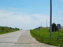
826:
695:
637:
512:
372:
364:
332:
295:
280:
114:
360:
291:
309:
264:
143:
911:
522:
1.000 mi = 1.609 km; 1.000 km = 0.621 mi
286:
There have been two instances of Iowa 98 since Iowa's
607:
549:
2011 Volume of
Traffic on the Primary Road System of Iowa
899:
894:
314:
Iowa 98 before decommissioning in
Village Township
382:In early 1933, Iowa 16 was extended west from
163:
149:
139:
129:
124:
96:
80:
75:
67:
59:
46:
23:
752:(Map). Iowa State Highway Commission. April 1937
725:(Map). Iowa State Highway Commission. March 1936
825:Johnston, Louis; Williamson, Samuel H. (2023).
371:. In early 1936, Iowa 98 was extended to
779:(Map). Iowa State Highway Commission. May 1933
8:
16:Former state highway in Iowa, United States
806:(Map). Iowa State Highway Commission. 1954
588:(Map). Iowa State Highway Commission. 1945
409:
367:to Primary Road No. 8, which later became
209:
916:
575:
573:
543:
541:
539:
691:"Routing of Primary Road No. 98 in 1920"
535:
869:. Marshalltown, Iowa. January 24, 2018
290:was created in 1920. The first was a
20:
913:Template:Attached KML/Iowa Highway 98
468:
462:
444:
438:
7:
421:
63:1.814 mi (2.919 km)
14:
556:Iowa Department of Transportation
494:
488:
481:
475:
469:
445:
259:that ran from south to north in
230:
215:
105:
100:
84:
26:
846:Gross Domestic Product deflator
267:. It began at Clay Street in
1:
937:Former state highways in Iowa
827:"What Was the U.S. GDP Then?"
669:Iowa State Highway Commission
517:Road continues as CR V64
453:Road continues as CR V64
416:
345:annual average daily traffic
612:United States Census Bureau
375:on a road that crossed the
173:Iowa Primary Highway System
953:
318:Iowa 98 began in the
41:Iowa 98 highlighted in red
521:
516:
465:
457:
452:
441:
433:
428:
425:
420:
415:
412:
208:
168:
159:
120:
51:
39:
403:The entire route was in
391:Moines River to Leando.
113: / CR V64 north of
320:census-designated place
800:Iowa State Highway Map
773:Iowa State Highway Map
746:Iowa State Highway Map
719:Iowa State Highway Map
661:Iowa State Highway Map
582:Iowa State Highway Map
507: / CR V64 –
327:(120 m) from the
315:
288:Primary Highway System
608:"U.S. Census website"
313:
917:KML is from Wikidata
450:CR V64 (Clay Street)
848:figures follow the
399:Major intersections
347:of 1060 vehicles.
316:
633:"Iowa Highway 98"
558:. January 1, 2011
527:
526:
306:Route description
246:
245:
242:
241:
47:Route information
944:
907:
879:
878:
876:
874:
867:Times-Republican
859:
853:
843:
841:
839:
822:
816:
815:
813:
811:
805:
795:
789:
788:
786:
784:
778:
768:
762:
761:
759:
757:
751:
741:
735:
734:
732:
730:
724:
714:
708:
707:
705:
703:
687:
681:
680:
678:
676:
666:
656:
650:
649:
647:
645:
629:
623:
622:
620:
618:
604:
598:
597:
595:
593:
587:
577:
568:
567:
565:
563:
553:
545:
499:
498:
497:
492:
491:
486:
485:
484:
479:
478:
473:
472:
459:Village Township
449:
448:
423:
418:
410:
405:Van Buren County
377:Des Moines River
363:which connected
329:Des Moines River
273:Des Moines River
263:in southeastern
261:Van Buren County
238:
234:
233:
223:
219:
218:
210:
109:
108:
104:
103:
88:
87:
30:
21:
952:
951:
947:
946:
945:
943:
942:
941:
927:
926:
918:
915:
910:
909:
908:
892:
888:
883:
882:
872:
870:
863:"State Roundup"
861:
860:
856:
837:
835:
824:
823:
819:
809:
807:
803:
797:
796:
792:
782:
780:
776:
770:
769:
765:
755:
753:
749:
743:
742:
738:
728:
726:
722:
716:
715:
711:
701:
699:
689:
688:
684:
674:
672:
664:
658:
657:
653:
643:
641:
631:
630:
626:
616:
614:
606:
605:
601:
591:
589:
585:
579:
578:
571:
561:
559:
551:
547:
546:
537:
532:
523:
495:
493:
489:
487:
482:
480:
476:
474:
470:
446:
401:
369:U.S. Highway 34
353:
308:
300:U.S. Highway 34
298:to what is now
275:, and ended at
249:Iowa Highway 98
231:
229:
216:
214:
106:
101:
85:
76:Major junctions
42:
35:
34:
33:Iowa Highway 98
31:
17:
12:
11:
5:
950:
948:
940:
939:
929:
928:
925:
924:
891:
890:
889:
887:
886:External links
884:
881:
880:
854:
850:MeasuringWorth
844:United States
832:MeasuringWorth
817:
790:
763:
736:
709:
682:
651:
624:
599:
569:
534:
533:
531:
528:
525:
524:
519:
518:
515:
467:
464:
461:
455:
454:
451:
443:
440:
437:
431:
430:
427:
424:
419:
414:
400:
397:
352:
349:
307:
304:
271:, crossed the
244:
243:
240:
239:
226:
224:
206:
205:
204:
203:
198:
193:
188:
183:
177:
176:
166:
165:
164:Highway system
161:
160:
157:
156:
151:
147:
146:
141:
137:
136:
131:
127:
126:
122:
121:
118:
117:
98:
97:North end
94:
93:
82:
81:South end
78:
77:
73:
72:
69:
65:
64:
61:
57:
56:
52:Maintained by
49:
48:
44:
43:
40:
37:
36:
32:
25:
24:
15:
13:
10:
9:
6:
4:
3:
2:
949:
938:
935:
934:
932:
923:
920:
919:
914:
905:
901:
897:
896:
885:
868:
864:
858:
855:
851:
847:
834:
833:
828:
821:
818:
802:
801:
794:
791:
775:
774:
767:
764:
748:
747:
740:
737:
721:
720:
713:
710:
698:
697:
692:
686:
683:
670:
663:
662:
655:
652:
640:
639:
634:
628:
625:
613:
609:
603:
600:
584:
583:
576:
574:
570:
557:
550:
544:
542:
540:
536:
529:
520:
514:
510:
506:
502:
460:
456:
436:
432:
411:
408:
406:
398:
396:
392:
389:
385:
380:
378:
374:
370:
366:
362:
358:
350:
348:
346:
342:
338:
334:
330:
325:
321:
312:
305:
303:
301:
297:
293:
289:
284:
282:
278:
274:
270:
266:
262:
258:
257:state highway
254:
250:
237:
227:
225:
222:
212:
211:
207:
202:
199:
197:
194:
192:
189:
187:
184:
182:
179:
178:
175:
174:
170:
169:
167:
162:
158:
155:
152:
148:
145:
142:
138:
135:
134:United States
132:
128:
123:
119:
116:
112:
99:
95:
92:
83:
79:
74:
70:
66:
62:
58:
55:
50:
45:
38:
29:
22:
19:
922:End of IA 98
893:
871:. Retrieved
866:
857:
849:
838:November 30,
836:. Retrieved
830:
820:
808:. Retrieved
799:
793:
781:. Retrieved
772:
766:
754:. Retrieved
745:
739:
727:. Retrieved
718:
712:
700:. Retrieved
694:
685:
673:. Retrieved
660:
654:
642:. Retrieved
636:
627:
615:. Retrieved
602:
590:. Retrieved
581:
560:. Retrieved
509:Libertyville
501:Iowa 16
426:Destinations
402:
393:
381:
357:Iowa 16
354:
341:Iowa 16
317:
285:
277:Iowa 16
253:Iowa 98
252:
248:
247:
236:Iowa 99
221:Iowa 96
171:
111:Iowa 16
18:
873:January 24,
810:January 22,
783:January 24,
756:January 24,
729:January 24,
702:January 22,
696:Google Maps
675:January 24,
644:January 24,
638:Google Maps
592:January 24,
562:January 24,
505:Iowa 1
384:Iowa 1
337:2010 Census
294:connecting
554:(Report).
530:References
388:Birmingham
361:spur route
292:spur route
181:Interstate
89:CR V64 in
322:(CDP) of
279:north of
196:Secondary
154:Van Buren
71:1944–2017
931:Category
895:KML file
852:series.
413:Location
255:) was a
150:Counties
125:Location
54:Iowa DOT
693:(Map).
667:(Map).
635:(Map).
617:May 14,
351:History
130:Country
68:Existed
671:. 1919
435:Leando
324:Leando
269:Leando
201:Scenic
91:Leando
60:Length
804:(PDF)
777:(PDF)
750:(PDF)
723:(PDF)
665:(PDF)
586:(PDF)
552:(PDF)
513:Eldon
466:2.919
463:1.814
442:0.000
439:0.000
429:Notes
386:near
373:Selma
365:Eldon
333:Douds
296:Eldon
281:Douds
191:State
140:State
115:Douds
904:help
900:edit
875:2018
840:2023
812:2011
785:2013
758:2013
731:2013
704:2011
677:2013
646:2013
619:2011
594:2013
564:2013
265:Iowa
144:Iowa
503:to
933::
902:•
865:.
829:.
610:.
572:^
538:^
511:,
422:km
417:mi
407:.
283:.
228:→
213:←
186:US
906:)
898:(
877:.
842:.
814:.
787:.
760:.
733:.
706:.
679:.
648:.
621:.
596:.
566:.
251:(
Text is available under the Creative Commons Attribution-ShareAlike License. Additional terms may apply.