
Download coordinates as:
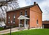
This is a list of properties and historic districts in Iowa that are listed on the National Register of Historic Places. There are listings in all of Iowa's 99 counties, adding up to over 2,300 total.
This National Park Service list is complete through NPS recent listings posted September 13, 2024.
Current listings by county
The following are approximate tallies of current listings by county. These counts are based on entries in the National Register Information Database as of April 24, 2008 and new weekly listings posted since then on the National Register of Historic Places web site. There are frequent additions to the listings and occasional delistings and the counts here are approximate and not official. New entries are added to the official Register on a weekly basis. Also, the counts in this table exclude boundary increase and decrease listings which modify the area covered by an existing property or district and which carry a separate National Register reference number. The numbers of NRHP listings in each county are documented by tables in each of the individual county list-articles.


| County | # of Sites | |
|---|---|---|
| 1 | Adair | 9 |
| 2 | Adams | 4 |
| 3 | Allamakee | 22 |
| 4 | Appanoose | 13 |
| 5 | Audubon | 15 |
| 6 | Benton | 16 |
| 7 | Black Hawk | 50 |
| 8 | Boone | 17 |
| 9 | Bremer | 12 |
| 10 | Buchanan | 20 |
| 11 | Buena Vista | 10 |
| 12 | Butler | 7 |
| 13 | Calhoun | 13 |
| 14 | Carroll | 18 |
| 15 | Cass | 11 |
| 16 | Cedar | 18 |
| 17 | Cerro Gordo | 47 |
| 18 | Cherokee | 12 |
| 19 | Chickasaw | 3 |
| 20 | Clarke | 8 |
| 21 | Clay | 9 |
| 22 | Clayton | 54 |
| 23 | Clinton | 30 |
| 24 | Crawford | 13 |
| 25 | Dallas | 18 |
| 26 | Davis | 12 |
| 27 | Decatur | 7 |
| 28 | Delaware | 14 |
| 29 | Des Moines | 34 |
| 30 | Dickinson | 12 |
| 31 | Dubuque | 85 |
| 32 | Emmet | 3 |
| 33 | Fayette | 29 |
| 34 | Floyd | 20 |
| 35 | Franklin | 12 |
| 36 | Fremont | 9 |
| 37 | Greene | 17 |
| 38 | Grundy | 3 |
| 39 | Guthrie | 8 |
| 40 | Hamilton | 8 |
| 41 | Hancock | 9 |
| 42 | Hardin | 35 |
| 43 | Harrison | 13 |
| 44 | Henry | 53 |
| 45 | Howard | 7 |
| 46 | Humboldt | 6 |
| 47 | Ida | 5 |
| 48 | Iowa | 11 |
| 49 | Jackson | 76 |
| 50 | Jasper | 16 |
| 51 | Jefferson | 29 |
| 52 | Johnson | 94 |
| 53 | Jones | 29 |
| 54 | Keokuk | 10 |
| 55 | Kossuth | 6 |
| 56 | Lee | 47 |
| 57 | Linn | 123 |
| 58 | Louisa | 9 |
| 59 | Lucas | 16 |
| 60 | Lyon | 10 |
| 61 | Madison | 53 |
| 62 | Mahaska | 48 |
| 63 | Marion | 28 |
| 64 | Marshall | 16 |
| 65 | Mills | 6 |
| 66 | Mitchell | 11 |
| 67 | Monona | 11 |
| 68 | Monroe | 11 |
| 69 | Montgomery | 19 |
| 70 | Muscatine | 40 |
| 71 | O'Brien | 3 |
| 72 | Osceola | 1 |
| 73 | Page | 9 |
| 74 | Palo Alto | 4 |
| 75 | Plymouth | 11 |
| 76 | Pocahontas | 3 |
| 77.1 | Polk: Des Moines | 186 |
| 77.2 | Polk: Other | 15 |
| 77.3 | Polk: Total | 201 |
| 78 | Pottawattamie | 41 |
| 79 | Poweshiek | 25 |
| 80 | Ringgold | 5 |
| 81 | Sac | 13 |
| 82.1 | Scott: Davenport: Downtown | 56 |
| 82.2 | Scott: Davenport: East | 91 |
| 82.3 | Scott: Davenport: West | 110 |
| 82.4 | Scott: Davenport: Duplicates | (2) |
| 82.5 | Scott: Other | 31 |
| 82.6 | Scott: Total | 286 |
| 83 | Shelby | 13 |
| 84 | Sioux | 4 |
| 85 | Story | 37 |
| 86 | Tama | 13 |
| 87 | Taylor | 7 |
| 88 | Union | 6 |
| 89 | Van Buren | 20 |
| 90 | Wapello | 31 |
| 91 | Warren | 12 |
| 92 | Washington | 19 |
| 93 | Wayne | 4 |
| 94 | Webster | 15 |
| 95 | Winnebago | 3 |
| 96 | Winneshiek | 34 |
| 97 | Woodbury | 60 |
| 98 | Worth | 6 |
| 99 | Wright | 8 |
| (duplicates) | (4) | |
| Total: | 2,459 | |
| Name on the Register | Image | Date listed | Location | City or town | Description | |
|---|---|---|---|---|---|---|
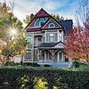
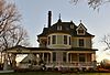
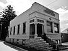
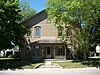
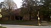
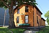
| 1 | Adams County Jail |  |
February 28, 1991 (#91000119) |
1000 Benton Ave. 40°59′32″N 94°44′04″W / 40.992222°N 94.734444°W / 40.992222; -94.734444 (Adams County Jail) | Corning | |
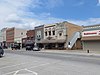
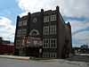
| 2 | Corning Commercial Historic District |  |
May 31, 2012 (#12000318) |
513-824 Davis Ave., 701-829 Benton Ave. & cross streets 40°59′21″N 94°44′05″W / 40.989066°N 94.734809°W / 40.989066; -94.734809 (Corning Commercial Historic District) | Corning | |
| 3 | Corning Opera House | Upload image | September 21, 1993 (#93000954) |
800 Davis Ave. 40°59′25″N 94°44′01″W / 40.990278°N 94.733611°W / 40.990278; -94.733611 (Corning Opera House) | Corning | |
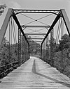
| 4 | Snider Bridge |  |
June 25, 1998 (#98000774) |
220th St. over an unnamed stream 40°59′28″N 94°36′38″W / 40.991111°N 94.610556°W / 40.991111; -94.610556 (Snider Bridge) | Corning |
Former listing
| Name on the Register | Image | Date listed | Date removed | Location | City or town | Description | |
|---|---|---|---|---|---|---|---|
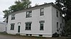
| 1 | Noah Odell House |  |
November 30, 2000 (#00000917) | January 24, 2022 | 1245 240th St. 40°57′35″N 94°50′45″W / 40.959722°N 94.845833°W / 40.959722; -94.845833 (Noah Odell House) | Nodaway |


| Name on the Register | Image | Date listed | Location | City or town | Description | |
|---|---|---|---|---|---|---|
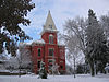
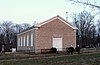
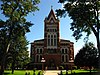
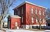
| 1 | Chickasaw County Courthouse |  |
July 2, 1981 (#81000228) |
Prospect St. at Locust Ave. 43°09′36″N 92°18′49″W / 43.16°N 92.313611°W / 43.16; -92.313611 (Chickasaw County Courthouse) | New Hampton | |
| 2 | Chickasaw Octagon House | Upload image | July 17, 1979 (#79000888) |
Court St. 43°02′11″N 92°29′58″W / 43.036389°N 92.499444°W / 43.036389; -92.499444 (Chickasaw Octagon House) | Chickasaw Township | |
| 3 | John Foley House | Upload image | April 16, 1979 (#79000889) |
511 N. Locust St. 43°03′52″N 92°18′49″W / 43.064444°N 92.313611°W / 43.064444; -92.313611 (John Foley House) | New Hampton |
Former listing
| Name on the Register | Image | Date listed | Date removed | Location | City or town | Description | |
|---|---|---|---|---|---|---|---|
| 1 | George Darrow Round Barn | Upload image | June 30, 1986 (#86001421) | September 8, 2022 | County Road T76 43°09′52″N 92°29′46″W / 43.164444°N 92.496111°W / 43.164444; -92.496111 (George Darrow Round Barn) | Alta Vista |


Former listing
| Name on the Register | Image | Date listed | Date removed | Location | City or town | Description | |
|---|---|---|---|---|---|---|---|
| 1 | Brady-Bolibaugh House | Upload image | January 3, 1985 (#85000003) | May 12, 2009 | 217 W. Washington 41°02′12″N 93°45′45″W / 41.036667°N 93.7625°W / 41.036667; -93.7625 (Brady-Bolibaugh House) | Osceola | Demolished in 2008 |


| Name on the Register | Image | Date listed | Location | City or town | Description | |
|---|---|---|---|---|---|---|
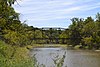
| 1 | Brugjeld-Peterson Family Farmstead District |  |
April 6, 2000 (#00000326) |
2349 450th Ave. 43°18′17″N 94°42′02″W / 43.304722°N 94.700556°W / 43.304722; -94.700556 (Brugjeld-Peterson Family Farmstead District) | Wallingford | |
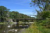
| 2 | Ellsworth Ranch Bridge | 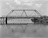 |
July 15, 1998 (#98000869) |
130th St. over the East Fork of the Des Moines River 43°27′36″N 94°34′49″W / 43.46°N 94.580278°W / 43.46; -94.580278 (Ellsworth Ranch Bridge) | Armstrong | |
| 3 | Thomsen Round Barn | Upload image | June 30, 1986 (#86001426) |
Off Iowa Highway 15 43°20′46″N 94°29′52″W / 43.346111°N 94.497778°W / 43.346111; -94.497778 (Thomsen Round Barn) | Armstrong |
| Name on the Register | Image | Date listed | Location | City or town | Description | |
|---|---|---|---|---|---|---|
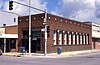
| 1 | Grundy Center High School |  |
September 18, 2020 (#100005565) |
1001 8th St. 42°21′30″N 92°46′26″W / 42.3584°N 92.7740°W / 42.3584; -92.7740 (Grundy Center High School) | Grundy Center | Not the current high school. |
| 2 | Grundy County Courthouse |  |
July 2, 1981 (#81000239) |
Grundy Ave. 42°21′31″N 92°46′18″W / 42.3586°N 92.7717°W / 42.3586; -92.7717 (Grundy County Courthouse) | Grundy Center | |
| 3 | Chris Neessen House | Upload image | January 12, 1984 (#84001253) |
601 E. 4th 42°26′04″N 92°55′29″W / 42.4344°N 92.9247°W / 42.4344; -92.9247 (Chris Neessen House) | Wellsburg |

Former listings
| Name on the Register | Image | Date listed | Date removed | Location | City or town | Description | |
|---|---|---|---|---|---|---|---|
| 1 | Panora-Linden High School | Upload image | July 23, 1974 (#74000786) | May 22, 1998 | Bounded by Main, Market, 1st, and 2nd Sts. | Panora | Torn down in 1991 |


Former listing
| Name on the Register | Image | Date listed | Date removed | Location | City or town | Description | |
|---|---|---|---|---|---|---|---|
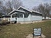
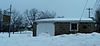
| 1 | South Ward School |  |
November 10, 1982 (#82000408) | September 19, 2019 | 500 S. Elm St. 43°22′03″N 92°07′02″W / 43.3675°N 92.117222°W / 43.3675; -92.117222 (South Ward School) | Cresco |


Former listing
| Name on the Register | Image | Date listed | Date removed | Location | City or town | Description | |
|---|---|---|---|---|---|---|---|
| 1 | Des Moines River Bridge | Upload image | May 15, 1998 (#98000522) | September 19, 2019 | Iowa Highway 3 over the West Fork of the Des Moines River 42°43′55″N 94°15′30″W / 42.731944°N 94.258333°W / 42.731944; -94.258333 (Des Moines River Bridge) | Humboldt | Replaced in 2010 |


Former listings
| Name on the Register | Image | Date listed | Date removed | Location | City or town | Description | |
|---|---|---|---|---|---|---|---|
| 1 | Turner Hall | Upload image | January 22, 1975 (#75000691) | June 21, 2007 | SE corner of Keil and 2nd Streets | Holstein | Demolished in March, 1975 |
Former listings
| Name on the Register | Image | Date listed | Date removed | Location | City or town | Description | |
|---|---|---|---|---|---|---|---|
| 1 | Longbottom Polygonal Barn | Upload image | June 30, 1986 (#86001456) | August 26, 2005 | Off Iowa Highway 226 | Titonka | Destroyed by fire in June 2003 |


Former listing
| Name on the Register | Image | Date listed | Date removed | Location | City or town | Description | |
|---|---|---|---|---|---|---|---|
| 1 | Judge Francis Springer House | Upload image | January 27, 1983 (#83000388) | September 5, 2000 | South of Columbus City | Columbus City | Burned by owner in October 1997. |

| Name on the Register | Image | Date listed | Location | City or town | Description | |
|---|---|---|---|---|---|---|
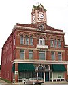
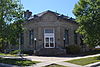
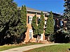
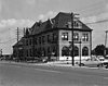
| 1 | Carnegie Library | 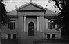 |
April 11, 1977 (#77001504) |
321 10th St. 43°10′47″N 95°51′14″W / 43.179722°N 95.853889°W / 43.179722; -95.853889 (Carnegie Library) | Sheldon | |
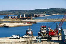
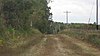
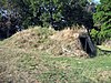
| 2 | Indian Village Site |  |
October 15, 1966 (#66000888) |
Left bank of Waterman Creek, east of Sutherland 42°58′50″N 95°25′22″W / 42.980556°N 95.422778°W / 42.980556; -95.422778 (Indian Village Site) | Sutherland | |
| 3 | O'Brien County Courthouse | 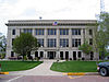 |
July 2, 1981 (#81000656) |
Fir Ave. 43°05′12″N 95°37′38″W / 43.086667°N 95.627222°W / 43.086667; -95.627222 (O'Brien County Courthouse) | Primghar |
| Name on the Register | Image | Date listed | Location | City or town | Description | |
|---|---|---|---|---|---|---|
| 1 | Osceola County Courthouse |  |
July 2, 1981 (#81000261) |
3rd Ave. and 8th St. 43°24′07″N 95°44′51″W / 43.401944°N 95.7475°W / 43.401944; -95.7475 (Osceola County Courthouse) | Sibley |
| Name on the Register | Image | Date listed | Location | City or town | Description | |
|---|---|---|---|---|---|---|
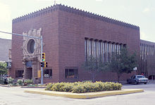
| 1 | Emmetsburg Public Library | 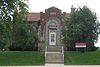 |
May 23, 1983 (#83000397) |
10th St. on Courthouse Sq. 43°05′19″N 94°41′52″W / 43.088611°N 94.697778°W / 43.088611; -94.697778 (Emmetsburg Public Library) | Emmetsburg | |
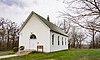
| 2 | First Presbyterian Church | Upload image | May 24, 2010 (#10000276) |
101 1st Ave. SW 42°57′35″N 94°26′47″W / 42.959683°N 94.446417°W / 42.959683; -94.446417 (First Presbyterian Church) | West Bend | |
| 3 | Grotto of the Redemption | 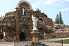 |
February 23, 2001 (#00001679) |
300 N. Broadway 42°57′50″N 94°26′44″W / 42.963889°N 94.445556°W / 42.963889; -94.445556 (Grotto of the Redemption) | West Bend | |
| 4 | Ormsby-Kelly House | Upload image | July 29, 1977 (#77000545) |
2403 W. 7th St. 43°06′46″N 94°41′02″W / 43.112778°N 94.683889°W / 43.112778; -94.683889 (Ormsby-Kelly House) | Emmetsburg |
| Name on the Register | Image | Date listed | Location | City or town | Description | |
|---|---|---|---|---|---|---|
| 1 | Laurens Carnegie Free Library |  |
November 5, 1974 (#74000804) |
263 N. 3rd St. 42°50′54″N 94°50′56″W / 42.848333°N 94.848889°W / 42.848333; -94.848889 (Laurens Carnegie Free Library) | Laurens | |
| 2 | Pocahontas County Courthouse |  |
July 2, 1981 (#81000264) |
Court Sq. 42°44′14″N 94°40′07″W / 42.737222°N 94.668611°W / 42.737222; -94.668611 (Pocahontas County Courthouse) | Pocahontas | |
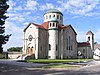
| 3 | Saints Peter and Paul Catholic Church | 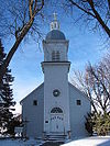 |
March 1, 1994 (#94000086) |
16 2nd Ave., NW. 42°44′05″N 94°40′15″W / 42.734722°N 94.670833°W / 42.734722; -94.670833 (Saints Peter and Paul Catholic Church) | Pocahontas |


Former listings
| Name on the Register | Image | Date listed | Date removed | Location | City or town | Description | |
|---|---|---|---|---|---|---|---|
| 1 | W.J. Buck Polygonal Barn | Upload image | June 30, 1986 (#86001471) | September 8, 2022 | Off U.S. Route 169 40°46′57″N 94°15′25″W / 40.7825°N 94.256944°W / 40.7825; -94.256944 (W.J. Buck Polygonal Barn) | Diagonal |


| Name on the Register | Image | Date listed | Location | City or town | Description | |
|---|---|---|---|---|---|---|
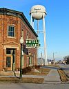
| 1 | Hotel Rea | Upload image | May 8, 2020 (#100004426) |
207 W. State St. 40°45′29″N 93°19′10″W / 40.757968°N 93.319468°W / 40.757968; -93.319468 (Hotel Rea) | Corydon | |
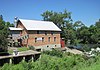
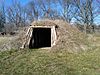
| 2 | Nelson Round Barn | 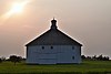 |
November 19, 1986 (#86003189) |
County Road J46 40°42′24″N 93°20′44″W / 40.706667°N 93.345556°W / 40.706667; -93.345556 (Nelson Round Barn) | Allerton | |
| 3 | Pleasant Hill School |  |
May 28, 1975 (#75000701) |
3 miles north of Lineville on U.S. Route 65 40°37′26″N 93°29′48″W / 40.623889°N 93.496667°W / 40.623889; -93.496667 (Pleasant Hill School) | Lineville | |
| 4 | W.H. Tedford House | 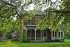 |
March 26, 1979 (#79000947) |
312 S. West St. 40°45′25″N 93°19′24″W / 40.756944°N 93.323333°W / 40.756944; -93.323333 (W.H. Tedford House) | Corydon |
| Name on the Register | Image | Date listed | Location | City or town | Description | |
|---|---|---|---|---|---|---|
| 1 | Round Barn, Norway Township | Upload image | February 27, 1987 (#87000507) |
Off County Road R60 43°29′22″N 93°35′51″W / 43.489444°N 93.5975°W / 43.489444; -93.5975 (Round Barn, Norway Township) | Norway Township | |
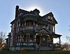
| 2 | Charles J. Thompson House | 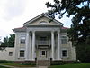 |
November 30, 1978 (#78001271) |
336 N. Clark St. 43°15′58″N 93°38′18″W / 43.266111°N 93.638333°W / 43.266111; -93.638333 (Charles J. Thompson House) | Forest City | |
| 3 | Winnebago County Courthouse |  |
July 2, 1981 (#81000275) |
J St. 43°15′47″N 93°38′19″W / 43.263056°N 93.638611°W / 43.263056; -93.638611 (Winnebago County Courthouse) | Forest City |
Former listings
| Name on the Register | Image | Date listed | Date removed | Location | City or town | Description | |
|---|---|---|---|---|---|---|---|
| 1 | Forest City Public Library | Upload image | April 5, 1984 (#84001609) | March 7, 2016 | E. I St. and Clark 43°15′56″N 93°38′15″W / 43.265556°N 93.6375°W / 43.265556; -93.6375 (Forest City Public Library) | Forest City |


See also
References
- National Park Service, United States Department of the Interior, "National Register of Historic Places: Weekly List Actions", retrieved September 13, 2024.
- "National Register Information System". National Register of Historic Places. National Park Service. April 24, 2008.
- "National Register of Historic Places: Weekly List Actions". National Park Service. Archived from the original on January 26, 2011. Retrieved January 2, 2009.
- Weekly List Actions, National Register of Historic Places website
- The Vander Veer Park Historic District is split between east and west Davenport. The Davenport Downtown Commercial Historic District is split between downtown and west Davenport.
- Effigy Mounds National Monument is split between Allamakee and Clayton counties; Le Grand Bridge (1896) is split between Marshall and Tama counties; County Line Bridge is split between Louisa and Washington counties; Bridgeport Bridge is split between Des Moines and Lee counties
- ^ Numbers represent an alphabetical ordering by significant words. Various colorings, defined here, differentiate National Historic Landmarks and historic districts from other NRHP buildings, structures, sites or objects.
- ^ The eight-digit number below each date is the number assigned to each location in the National Register Information System database, which can be viewed by clicking the number.
- "Welcome to Panora, Iowa -- Home to Beautiful Lake Panorama and the Raccoon River Valley Trail!!". Archived from the original on February 7, 2012. Retrieved January 9, 2012.
- "Turner Hall Now Only a Memory". The Sioux City Journal. March 3, 1975. p. A2. Retrieved June 25, 2022 – via Newspapers.com.
- Springer, Arthur. History of Louisa County Iowa From Its Earliest Settlement to 1912. Vol. 1. Chicago: Clarke, 1912, 13.
- Address derived from this Louisa County Conservation Board page; the NRIS lists the site as "Address Restricted".
- "The Springer House". www.louisacountyhistory.com. Archived from the original on December 8, 2012. Retrieved January 15, 2022.
- "Slipping away". Muscatine Journal. September 27, 1997. p. 9. Retrieved June 26, 2022 – via Newspapers.com.
- Vis, Robert B., and Dale R. Henning. "A Local Sequence for Mill Creek Sites in the Little Sioux River Valley". Plains Anthropologist 14.46 (1969): 253-271: 254.

| Topics | |
|---|---|
| Lists by state |
|
| Lists by insular areas | |
| Lists by associated state | |
| Other areas | |
| Related | |