236:, Mexico, Friar Antonio's ship was overtaken by Dutch pirates who found and confiscated a map drawn by him that depicted California as an island, effectively leaking state-secret information. Spain was not in the habit of willingly sharing information about their expeditions— in fact, maps produced by Sebastián Vizcaíno, the leader of the expedition that brought Fray Antonio De La Ascension to California, were not published until 1802, two hundred years after the expedition occurred. Shortly after the map was confiscated from Friar Antonio's ship, Dutch maps were published depicting California as an island. At the bottom left corner of a British map from 1630 drawn by Henry Briggs is scribbled "California, sometimes supposed to be a part of the western continent, but since by a Spanish chart taken from Hollanders, it is found to be a goodly island". This stolen map was Friar Antonio's, and this quote provides evidence for the spread of knowledge of California as an island. As the Dutch were reputable cartographers, it is thought that word of California as an island began to spread, as the majority of maps depicting California as an island were published after 1622. Throughout the 1600s, the Dutch, Japanese, French, Germans, British, and more all drew California as an island.
247:. Finding a Northwest Passage was something that motivated many of the explorers coming to the California coast at the time, as it would be extremely profitable for Europe if a northern trade route to Asia could be found. In fact, explorers like Sebastián Vizcaíno were operating under orders to sail north until they found the Northwest Passage, and only to turn around if the coast veered northwest, which would imply that there was no waterway and the land was actually connected to Asia. De Fuca's claim remains controversial because there is only one surviving written account of it found, his account as related to an Englishman,
60:
121:. This mapping error was not a one-off event. From the mid-1500s to the late 1700s great controversy surrounded the geography of California. For instance, a Spanish map from 1548 depicts California as a peninsula, while a 1622 Dutch map depicts California as an island. A 1626 Portuguese map depicts the land as a peninsula, while a 1630 British map depicts it as an island. A French map from 1682 only shows the tip of the Baja Peninsula. There are slightly over 1,000 maps in Stanford's
71:
29:
326:'s explorations of the west coast of California in 1602 and 1603. Ascención was a tireless propagandist in favor of Spanish settlement in California, and his later writings referred to the region as an island. As older maps confirm, Spanish authorities and local residents were well aware where the actual northern terminus of the Gulf of California lay, but by extending the coastline north past
224:
Rather than many cartographers independently making the same mistake, it is thought that maps of
California as an island spread due to copying in the early 1600s, since it is known that cartographers of the time frequently made copies of other maps. Interestingly, the first maps depicting California
283:
just off the west coast of
Vancouver Island at about 49° N. His account states "we saw nothing like ; nor is there the least probability that ever any such thing existed." However, Cook describes some bad weather in his account around this time, and did continue on to map most of the outer Pacific
362:
in 1698–1706, in part to provide a practical route between the
Jesuits' missions in Sonoran and Baja California but also to resolve the geographical question. Kino satisfied himself that a land connection must exist, and the 18th century Jesuits generally followed his example. The first report of
196:
and reported on their find. In 1535, Cortés arrived in the bay there and named the area Santa Cruz; he attempted to start a colony but abandoned his efforts after several years due to logistical problems. Cortés' limited information on southern Baja
California apparently led to the naming of the
841:
A Voyage to the
Pacific Ocean: Undertaken by the Command of His Majesty, for Making Discoveries in the Northern Hemisphere, to Determine the Position and Extent of the West Side of North America, its Distance from Asia, and the Practicability of a Northern Passage to Europe,
208:
at the head of the Gulf, which seemed to prove that the region was a peninsula rather than an island. Ulloa was quoted as having described the land he saw on his expedition as, "High and bare, of wretched aspect without any verdure." An expedition under
112:
errors in history, it was propagated on many maps during the 17th and 18th centuries, despite contradictory evidence from various explorers. The legend was initially infused with the idea that
California was a terrestrial paradise, like the
839:
353:
revived the fact that Baja
California was a peninsula. While studying in Europe, Kino had accepted the insularity of California, but when he reached Mexico he began to have doubts. He made a series of overland expeditions from northern
267:. It is possible that explorers and mapmakers in the 17th century could have confused the two (if, in fact, they were aware of de Fuca's voyage), and in any case further exploration was inevitable. Indeed, the famed British explorer
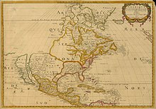
530:
Sabed que a la diestra mano de las Indias ovo una Isla llamada
California mucho llegada a la parte del paraiso terrenal la qual fue poblada de mugeres negras sin que algun varon entre ellas oviesse: que casi como las amazonas
159:
Know, that on the right hand of the Indies there is an island called
California very close to the side of the Terrestrial Paradise; and it is peopled by black women, without any man among them, for they live in the manner of
172:
at the time of
European exploration of California, that it is reasonable that the book inspired the naming of California. The book's description is also thought to have prompted early explorers to misidentify the
375:, now Slovenia). In a June 1701 letter, he wrote about that to his friend Philippus Alberth in Vienna and thus acted as an important intermediary in the dissemination of this knowledge. However,
315:, but was more likely due to the California Superflood of 1605, in which the flooded Central and Indio Valley basins did essentially appear to extend the peninsula hundreds of miles northward).
620:
583:
303:. The expedition descended the Colorado River in 1604 and 1605, and its participants believed that they saw the Gulf of California continuing off to the northwest (presumably behind the
243:
in 1592. De Fuca claimed to have explored the western coast of North America and to have found a large opening that possibly connected to the Atlantic Ocean — the legendary
998:
98:
213:
ascended the lower Colorado River and confirmed Ulloa's finding. Maps published subsequently in Europe during the 16th century, including those by
938:
An anthology of writings that describe Baja California, and the Gulf of California, from sources dated from the mid-sixteenth century to present.
229:
friar Antonio De La Ascension, a priest at the top of the Spanish church, was the first known person to depict California as an island in 1603.
993:
931:
776:
597:
913:
811:
638:
558:
476:
Glen McLaughlin Collection of California as an Island. McLaughlin map number 1189. Green Library, Stanford University, Stanford, CA.
379:, a military companion on several of Kino's treks, expressed scepticism; European cartographers remained divided on the question.
295:
A key role in changing ideas about California seems to have been played by an overland expedition led by the founding governor of
1003:
978:
489:
Glen McLaughlin Collection of California as an Island. McLaughlin map number 2. Green Library, Stanford University, Stanford, CA.
973:
515:
144:
983:
412:
589:
189:
296:
137:
505:
McLaughlin, Glen. Glen McLaughlin Collection of California as an Island, Stanford Libraries. Accessed 15 Feb. 2023.
968:
900:
174:
534:(The first mention of "California" occurs on the unnumbered (verso) page after page CVIII, in the right column.)
988:
368:
248:
197:
region after the legendary California and to an initial but short-lived assumption that it was a large island.
323:
59:
251:. Nonetheless, this account claims de Fuca found a large strait, with a large island at its mouth, at around
486:
473:
387:
364:
616:
308:
256:
210:
431:
395:
304:
870:
Laylander, Don, 2004. "Geographies of Fact and Fantasy: Oñate on the Lower Colorado River, 1604–1605".
382:
Jesuit missionary-explorers in Baja California who attempted to lay the issue finally to rest included
376:
359:
181:
659:
264:
252:
519:
271:
narrowly missed the Strait of Juan de Fuca in March 1778, almost 200 years later. Cook even named
185:
133:
The first known mention of the legend of the "Island of California" was in the 1510 romance novel
28:
407:
276:
201:
102:
75:
40:
897:
California as an Island: A Geographical Misconception Illustrated by 100 Examples from 1625–1770
363:
Kino's discovery and his map from 1701 showing California as a peninsula were sent to Europe by
150:
204:
northward along the Gulf and Pacific coasts of Baja California. Ulloa reached the mouth of the
70:
927:
817:
807:
782:
772:
645:
Sin embargo, es indudable que Cortés, el envidiado, habló de una isla de riqueza fantástica."
634:
593:
564:
554:
372:
244:
214:
688:
263:, while the northern reach of the Gulf of California terminates much farther south, at about
391:
300:
260:
218:
86:
48:
952:
398:
traveled between Sonora and the west coast of Alta California in the period of 1774–1776.
94:
948:
667:
383:
327:
205:
114:
64:
962:
335:
312:
285:
272:
101:
but rather a large island separated from the continent by a strait now known as the
350:
280:
240:
44:
259:
is in fact at around 48° N, as is the southern tip of the large island now called
921:
342:
for England (1579) could be invalidated by the priority of Cortes' claim (1533).
339:
331:
109:
22:
93:) was a long-held global misconception, dating from the 16th century, that the
835:
716:
319:
268:
226:
786:
821:
568:
193:
52:
740:
394:(1766). The matter was settled beyond all dispute when the expeditions of
801:
689:"::: World and Regional Maps Collection, 16th to 19th Centuries :::"
548:
233:
188:, discovered the southern portion of Baja California, around present-day
118:
161:
622:
Descubrimientos y exploraciones en las costas de California, 1532–1650
284:
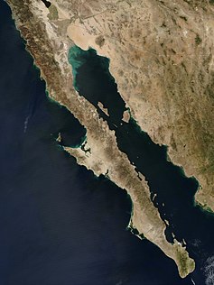
coastline of North America from modern-day northern California to the
47:
in the center of the map marks the approximate location of the modern
846:
766:
630:
627:
Discoveries and explorations along the coast of California, 1532–1650
355:
346:
289:
318:
Reports from Oñate's expedition reached Antonio de la Ascención, a
69:
58:
27:
21:"California Island" redirects here. For the rock music album, see
155:, father of Esplandian. He described the island in this passage:
890:
The Mapping of California as an Island: An Illustrated Checklist
768:
Historical atlas of the American West : with original maps
463:. San Francisco, [Calif.: Book Club of California, 1972. Print.
239:
Another contributing factor may have been the second voyage of
803:
Mapping the West : America's westward movement 1524-1890
168:
It is thought that, because of the widespread popularity of
279:
state) which is at the mouth of the strait, and stopped in
74:
A satellite view of the Baja California peninsula and the
225:
as an island originated after a series of correct maps.
885:. Universidad Nacional Autónoma de México, Mexico City.
436:
California as an Island in Maps - Spotlight at Stanford
123:
Glen McLaughlin Collection of California as an Island
648:(The 1944 edition was the author's doctoral thesis.)
455:
453:
125:, the largest collection of such maps in the world.
221:, correctly showed Baja California as a peninsula.
192:. He was killed by natives but his men returned to
553:. Rochester, N.Y.: University of Rochester Press.
459:Leighly, John, Robert Grabhorn, and Andrew Hoyem.
741:"Brief Report of the Discovery in the South Sea"
184:, a mutineer on an exploring expedition sent by
881:Cartografía y crónicas de la antigua California
604:Cortés Believes Baja California to be an Island
585:The Island of California: A History of the Myth
147:—the sequel to Montalvo's more famous tales of
892:. Saratoga, CA: California Map Society, 1995 .
718:The Biggest Mapping Mistake of 𝗔𝗟𝗟 𝗧𝗜𝗠𝗘
879:
461:California As an Island: An Illustrated Essay
148:
135:
63:The "Island of California", on a 1650 map by
8:
923:Isle of the Amazons In the Vermilion Sea
423:
888:McLaughlin, Glen, with Nancy H. Mayo.
711:
709:
7:
582:Polk, Dora Beale (October 1, 1995).
542:
540:
501:
499:
497:
495:
629:] (in Spanish) (2nd ed.).
200:In 1539, Cortés sent the navigator
926:. Kansas City, MO: 39 West Press.
914:Bibliography of California history
771:. University of California Press.
14:
999:History of the Gulf of California
849:: W. and A. Strahan. p. 263
633:: Ediciones Rialp. p. 140.
275:(at the northwest tip of modern
177:as the island in these legends.
949:California as an Island in Maps
322:friar who had participated in
1:
877:León-Portilla, Miguel. 1989.
872:Southern California Quarterly
658:Wood, Mark (March 11, 2014).
547:Schwartz, Seymour I. (2003).
413:Origin of the name California
33:
994:Obsolete scientific theories
590:University of Nebraska Press
526:The Adventures of Esplandián
516:Rodríguez de Montalvo, Garci
358:to areas within or near the
349:missionary and cartographer
920:MacDonald, Gregory (2019).
367:, a Jesuit missionary from
145:Garci Rodríguez de Montalvo
49:United States–Mexico border
1022:
911:
693:content.lib.washington.edu
660:"The Island of California"
472:Gastaldi, Giacomo (1548).
20:
550:The mismapping of America
330:and eventually even into
175:Baja California peninsula
97:was not part of mainland
521:Las sergas de Esplandián
297:Santa Fe de Nuevo México
232:On the return voyage to
170:Las sergas de Esplandián
138:Las sergas de Esplandián
1004:Etymology of California
979:Latin American folklore
800:Cohen, Paul E. (2002).
664:Pomona College Magazine
108:One of the most famous
901:Map Collectors' Circle
880:
485:Briggs, Henry (1625).
365:Marcus Antonius Kappus
360:Colorado River's delta
351:Eusebio Francisco Kino
257:Strait of Juan de Fuca
166:
149:
136:
90:
78:
67:
56:
974:Symbols of California
806:. New York: Rizzoli.
765:Hayes, Derek (2009).
588:. Spain in the West.
396:Juan Bautista de Anza
305:Sierra de Los Cucapah
157:
73:
62:
31:
984:Mythological islands
895:Tooley, R. V. 1964.
721:, September 14, 2022
617:Portillo, Álvaro del
528:] (in Spanish).
292:on the same voyage.
83:Island of California
211:Hernando de Alarcón
32:Map of California,
951:online exhibit of
487:Map of California.
474:Map of California.
438:. February 7, 2016
408:Mapping California
324:Sebastián Vizcaíno
253:47° north latitude
202:Francisco de Ulloa
103:Gulf of California
91:Isla de California
79:
76:Gulf of California
68:
57:
41:Johannes Vingboons
933:978-1-946358-14-1
778:978-0-520-25652-1
745:American Journeys
739:Bolton, Herbert.
599:978-0-8032-8741-9
388:Ferdinand Konščak
373:Duchy of Carniola
245:Northwest Passage
215:Gerardus Mercator
95:California region
1011:
969:Spanish folklore
937:
883:
859:
858:
856:
854:
832:
826:
825:
797:
791:
790:
762:
756:
755:
753:
751:
736:
730:
729:
728:
726:
713:
704:
703:
701:
699:
685:
679:
678:
676:
674:
655:
649:
647:
613:
607:
606:
579:
573:
572:
544:
535:
533:
512:
506:
503:
490:
483:
477:
470:
464:
457:
448:
447:
445:
443:
428:
392:Wenceslaus Linck
377:Juan Mateo Manje
261:Vancouver Island
219:Abraham Ortelius
154:
141:
43:; restored. The
38:
35:
1021:
1020:
1014:
1013:
1012:
1010:
1009:
1008:
989:Phantom islands
959:
958:
953:Glen McLaughlin
945:
934:
919:
916:
910:
908:Further reading
867:
862:
852:
850:
834:
833:
829:
814:
799:
798:
794:
779:
764:
763:
759:
749:
747:
738:
737:
733:
724:
722:
715:
714:
707:
697:
695:
687:
686:
682:
672:
670:
657:
656:
652:
641:
615:
614:
610:
600:
592:. p. 105.
581:
580:
576:
561:
546:
545:
538:
514:
513:
509:
504:
493:
484:
480:
471:
467:
458:
451:
441:
439:
430:
429:
425:
421:
404:
151:Amadís de Gaula
131:
36:
26:
17:
12:
11:
5:
1019:
1018:
1015:
1007:
1006:
1001:
996:
991:
986:
981:
976:
971:
961:
960:
957:
956:
944:
943:External links
941:
940:
939:
932:
912:Main article:
909:
906:
905:
904:
893:
886:
875:
866:
863:
861:
860:
827:
812:
792:
777:
757:
731:
705:
680:
668:Pomona College
650:
639:
608:
598:
574:
559:
536:
507:
491:
478:
465:
449:
422:
420:
417:
416:
415:
410:
403:
400:
384:Juan de Ugarte
328:Cape Mendocino
206:Colorado River
182:Fortún Ximénez
130:
127:
115:Garden of Eden
65:Nicolas Sanson
16:Phantom island
15:
13:
10:
9:
6:
4:
3:
2:
1017:
1016:
1005:
1002:
1000:
997:
995:
992:
990:
987:
985:
982:
980:
977:
975:
972:
970:
967:
966:
964:
954:
950:
947:
946:
942:
935:
929:
925:
924:
918:
917:
915:
907:
902:
898:
894:
891:
887:
884:
882:
876:
873:
869:
868:
864:
848:
845:Vol. 2.
844:
843:
837:
831:
828:
823:
819:
815:
813:0-8478-2492-6
809:
805:
804:
796:
793:
788:
784:
780:
774:
770:
769:
761:
758:
746:
742:
735:
732:
720:
719:
712:
710:
706:
694:
690:
684:
681:
669:
665:
661:
654:
651:
646:
642:
640:9788432121890
636:
632:
628:
624:
623:
618:
612:
609:
605:
601:
595:
591:
587:
586:
578:
575:
570:
566:
562:
560:1-58046-129-8
556:
552:
551:
543:
541:
537:
532:
527:
523:
522:
517:
511:
508:
502:
500:
498:
496:
492:
488:
482:
479:
475:
469:
466:
462:
456:
454:
450:
437:
433:
427:
424:
418:
414:
411:
409:
406:
405:
401:
399:
397:
393:
389:
385:
380:
378:
374:
370:
366:
361:
357:
352:
348:
343:
341:
337:
336:Francis Drake
333:
329:
325:
321:
316:
314:
313:Lake Cahuilla
310:
309:Laguna Salada
306:
302:
301:Juan de Oñate
298:
293:
291:
287:
286:Bering Strait
282:
278:
274:
273:Cape Flattery
270:
266:
262:
258:
254:
250:
249:Michael Locke
246:
242:
237:
235:
230:
228:
222:
220:
216:
212:
207:
203:
198:
195:
191:
187:
186:Hernán Cortés
183:
178:
176:
171:
165:
163:
156:
153:
152:
146:
142:
140:
139:
128:
126:
124:
120:
116:
111:
106:
104:
100:
99:North America
96:
92:
88:
84:
77:
72:
66:
61:
54:
50:
46:
42:
30:
24:
19:
922:
896:
889:
878:
871:
851:. Retrieved
840:
830:
802:
795:
767:
760:
748:. Retrieved
744:
734:
723:, retrieved
717:
696:. Retrieved
692:
683:
671:. Retrieved
663:
653:
644:
626:
621:
611:
603:
584:
577:
549:
529:
525:
520:
510:
481:
468:
460:
440:. Retrieved
435:
426:
390:(1746), and
381:
369:Kamna Gorica
344:
338:'s claim of
317:
294:
281:Nootka Sound
241:Juan de Fuca
238:
231:
223:
199:
179:
169:
167:
158:
134:
132:
122:
110:cartographic
107:
82:
80:
45:compass rose
18:
874:86:309–324.
836:Cook, James
750:February 2,
442:February 9,
340:Nova Albion
332:Puget Sound
51:, south of
37: 1650
23:Dirty Heads
963:Categories
955:collection
865:References
311:Basin and
277:Washington
269:James Cook
903:, London.
787:494554476
619:(1982) .
518:(1526) .
432:"History"
320:Carmelite
307:into the
227:Carmelite
194:New Spain
180:In 1533,
53:San Diego
838:(1784).
822:50717269
725:March 1,
698:March 1,
673:July 10,
569:51235174
402:See also
386:(1721),
234:Acapulco
119:Atlantis
853:May 31,
162:Amazons
129:History
87:Spanish
930:
847:London
820:
810:
785:
775:
637:
631:Madrid
596:
567:
557:
356:Sonora
347:Jesuit
290:Alaska
255:. The
190:La Paz
625:[
524:[
419:Notes
265:31° N
39:, by
928:ISBN
855:2018
818:OCLC
808:ISBN
783:OCLC
773:ISBN
752:2023
727:2023
700:2023
675:2014
635:ISBN
594:ISBN
565:OCLC
555:ISBN
444:2023
345:The
217:and
81:The
842:...
531:...
288:in
143:by
117:or
965::
899:.
816:.
781:.
743:.
708:^
691:.
666:.
662:.
643:.
602:.
563:.
539:^
494:^
452:^
434:.
334:,
299:,
105:.
89::
34:c.
936:.
857:.
824:.
789:.
754:.
702:.
677:.
571:.
446:.
371:(
164:.
85:(
55:.
25:.
Text is available under the Creative Commons Attribution-ShareAlike License. Additional terms may apply.