500:, Jamboree Heights had a population of 3,057 people, 49.4% female and 50.6% male. The median age of the Jamboree Heights population was 36 years of age, 1 year below the Australian median. 95.3% of people living in Jamboree Heights were born in Australia, compared to the national average of 69.8%; the next most common countries of birth were New Zealand 4.7%, England 3.7%, Vietnam 3%, South Africa 2%, China 1.9%. 92% of people spoke only English at home; the next most common languages were 4% Vietnamese, 2.8% Cantonese, 2.1% Mandarin, 1% Arabic, 0.8% Gujarati.
102:
1013:
979:
667:
86:
109:
458:
The western part of the original land holdings that became the
Centenary Suburbs were part of the Wolston Estate, consisting of 54 farms on an area of 3,000 acres (1,200 ha), offered for auction at Centennial Hall, Brisbane, on 16 October 1901. Only three of the farms sold at the original
1088:
403:
134:
525:
1036:
271:
259:
687:
1183:
712:
1084:
562:). In 2017, the school had an enrolment of 819 students with 61 teachers (50 full-time equivalent) and 27 non-teaching staff (16 full-time equivalent). It includes a
393:, to the south by Sumners Road, to the west by Estate Road and Beanland Street, to the north-west by Lofts Road and Dandenong Road and to the north by the
101:
448:
Wolston Estate was the property of M. B. Goggs, whose father obtained the land forty years previously in the 1860s and after whom Goggs Road is named.
2243:
1028:
1176:
942:
241:
606:
There are multiple bus services going to and from Mount
Ommaney Shopping Centre Bus Exchange to the city and other locations including:
264:
1305:
359:
1169:
934:
679:
522:
Jamboree
Heights State School is a government primary (Early Childhood to Year 6) school for boys and girls at 35 Beanland Street (
907:
623:
There is also a S703 run which is open to the public, but is mainly used by school students heading to
Kenmore State High School.
2069:
862:
781:
23:
2129:
991:
957:
645:
1984:
1355:
815:
1884:
1824:
394:
1630:
1600:
1385:
478:
127:
2109:
1470:
1375:
1290:
570:
2084:
1904:
1779:
1754:
1645:
1555:
1550:
1500:
1330:
50:
2094:
2079:
1979:
1969:
1874:
1819:
1740:
1455:
1425:
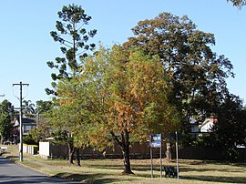
1360:
1300:
1285:
884:
482:
322:
307:
302:
297:
45:
2179:
1879:
1685:
1635:
1535:
1505:
1445:
1435:
1365:
1245:
288:
477:'Centenary Project' to develop land which commenced in 1959. The suburb of Jamboree Heights was named by the
40:
2217:
2174:
2064:
1999:
1964:
1959:
1849:
1839:
1829:
1814:
1799:
1735:
1700:
1585:
1580:
1400:
1370:
1320:
1280:
1255:
314:
400:
The land use of the suburb is predominantly residential. There is a small shopping centre in Guide Street (
2114:
2034:
1949:
1844:
1565:
1545:
1490:
1380:
1345:
1315:
1310:
1270:
1250:
1114:
1062:
995:
961:
649:
595:
511:
504:
497:
371:
195:
179:
2212:
2154:
2104:
2059:
2044:
2039:
2029:
2014:
1954:
1939:
1934:
1919:
1909:
1864:
1859:
1834:
1789:
1759:
1730:
1725:
1660:
1615:
1525:
1515:
1390:
1335:
1325:
1032:
720:
452:
2149:
2144:
2139:
2124:
2119:
2089:
2074:
1989:
1974:
1899:
1804:
1764:
1705:
1695:
1690:
1665:
1640:
1595:
1590:
1575:
1570:
1560:
1520:
1510:
1480:
1475:
1410:
1350:
1295:
1275:
1235:
1220:
776:
574:
2184:
2159:
2054:
2049:
2024:
2009:
1869:
1854:
1784:
1769:
1720:
1715:
1710:
1655:
1650:
1620:
1610:
1495:
1460:
1450:
1430:
1420:
1395:
1225:
1151:
750:
598:
Training Ship (TS Vengeance) located on
Moolanda Street, close to the Centenary State High School.
2202:
2169:
2099:
1994:
1929:
1914:
1809:
1774:
1749:
1605:
1540:
1530:
1485:
1440:
1415:
1405:
1340:
1265:
1240:
1215:
902:
390:
334:
329:
619:
106 (Mount
Ommaney, Sinnamon Park, Oxley, Corinda, Sherwood, Graceville, Chelmer, Indooroopilly)
455:
was created. In 1891, parts of
Yeerongpilly Division were excised to create Sherwood Division.
2134:
2004:
1944:
1889:
1794:
1465:
1260:
1230:
1161:
938:
563:
463:
339:
276:
213:
2019:
1924:
1193:
857:
467:
466:
which contained the
Wolston Estate. In 1925, the Shire of Sherwood was amalgamated into the
363:
246:
35:
1012:
978:
666:
780:. Vol. LVIII, no. 13, 651. Queensland, Australia. 12 October 1901. p. 4.
591:
An
Ambulance Station is located on Westcombe St and can be contacted on (07) 3895 3911.
2222:
1677:
1207:
2237:
2164:
861:. Vol. LXI, no. 1353. Queensland, Australia. 26 October 1901. p. 780.
251:
85:
383:
234:
1140:
807:
588:
A Fire
Station is located at 238 Arrabri Ave and can be phoned on (07) 3279 0536.
569:
There is no secondary school in Jamboree Heights. The nearest secondary school is
2207:
2194:
1197:
897:
585:
A Police Beat is located at 31 Lanena St and can be phoned on (07) 3376 8092.
367:
222:
76:
852:
771:
541:
527:
419:
405:
150:
136:
838:
474:
746:
610:
454 (Riverhills, Mount Ommaney Bus Exchange, Indooroopilly, Toowong, City)
382:
Jamboree Heights is 16.2 km (10.1 mi) by road south west of the
72:
906:. Australian Capital Territory, Australia. 28 December 1967. p. 7.
1625:
1147:. Centre for the Government of Queensland, University of Queensland.
1110:
1058:
218:
1165:
713:"Jamboree Heights – suburb in City of Brisbane (entry 41940)"
613:
460 (Heathwood, Forest Lake, Mt Ommaney, Indooroopilly, City)
1156:
488:
Jamboree Heights State School opened on 29 January 1974.
481:
on 1 July 1969. The name reflects the hosting of the 8th
808:"Suburban conservatism in the Sherwood Shire 1891-1920"
514:, Jamboree Heights had a population of 3,141 people.
507:, Jamboree Heights had a population of 3,093 people.
374:, Jamboree Heights had a population of 3,141 people.
841:" (1901) . Collections. State Library of Queensland.
2193:
1674:
1204:
270:
258:
240:
229:
212:
204:
194:
186:
174:
126:
66:
1152:ourbrisbane.com website, Jamboree Heights section
1111:"Jamboree Heights SS – Special Education Program"
1023:
1021:
283:
887:, 11 November 1961. Retrieved 25 November 2017.
616:453 (Mt Ommaney, Jindalee, Indooroopilly, City)
389:Jamboree Heights is bounded to the east by the
1177:
8:
640:
638:
636:
1184:
1170:
1162:
1011:
977:
929:Queensland Family History Society (2010),
873:– via National Library of Australia.
792:– via National Library of Australia.
665:
462:In 1903, the Sherwood Division became the
84:
63:
1157:Centenary Suburbs Historical Society Inc.
61:Suburb of Brisbane, Queensland, Australia
741:
739:
737:
108:
632:
707:
705:
451:In 1879, the local government area of
1091:from the original on 22 November 2018
1039:from the original on 21 November 2018
327:
312:
295:
285:
7:
1029:"State and non-state school details"
865:from the original on 10 October 2020
801:
799:
784:from the original on 10 October 2020
931:Queensland schools past and present
898:"Scouts head for Brisbane jamboree"
485:in December 1967 and January 1968.
162:Jamboree Heights (centre of suburb)
90:Jamboree Park in Guide Street, 2009
1117:from the original on 4 August 2012
1065:from the original on 4 August 2012
690:from the original on 12 March 2017
14:
935:Queensland Family History Society
818:from the original on 2 March 2020
473:Jamboree Heights was part of the
431:Shopping centre, Jamboree Heights
208:1.2 km (0.5 sq mi)
910:from the original on 21 May 2022
233:16.1 km (10 mi) SW of
107:
100:
2244:Suburbs of the City of Brisbane
1059:"Jamboree Heights State School"
992:Australian Bureau of Statistics
958:Australian Bureau of Statistics
806:Fones, Ralph (1 January 2020).
646:Australian Bureau of Statistics
1:
553:Jamboree Heights State School
395:Mount Ommaney Shopping Centre
479:Queensland Place Names Board
1085:"ACARA School Profile 2017"
571:Centenary State High School
190:2,620/km (6,780/sq mi)
51:GPX (secondary coordinates)
2260:
839:Plan of the Wolston Estate
933:(Version 1.01 ed.),
885:The Sydney Morning Herald
483:Australian Scout Jamboree
345:
286:
282:
95:
83:
46:GPX (primary coordinates)
21:Map all coordinates using
996:"Jamboree Heights (SSC)"
962:"Jamboree Heights (SSC)"
772:"SALE OF WOLSTON ESTATE"
650:"Jamboree Heights (SAL)"
291:around Jamboree Heights:
29:Download coordinates as:
1000:2016 Census QuickStats
966:2011 Census QuickStats
853:"LATEST NEWS IN BRIEF"
717:Queensland Place Names
654:2021 Census QuickStats
596:Australian Naval Cadet
420:27.5581°S 152.932686°E
1033:Queensland Government
721:Queensland Government
684:Brisbane City Council
453:Yeerongpilly Division
41:GPX (all coordinates)
2070:Seventeen Mile Rocks
883:"Town To Be Built",
777:The Brisbane Courier
542:27.5548°S 152.9289°E
425:-27.5581; 152.932686
370:, Australia. In the
151:27.5547°S 152.9327°E
2130:Upper Mount Gravatt
960:(31 October 2012).
751:State of Queensland
537: /
415: /
358:is a south-western
272:Federal division(s)
260:State electorate(s)
146: /
1985:Mount Gravatt East
1356:Enoggera Reservoir
1141:"Jamboree Heights"
918:– via Trove.
903:The Canberra Times
747:"Queensland Globe"
547:-27.5548; 152.9289
391:Centenary Motorway
156:-27.5547; 152.9327
2231:
2230:
1885:Holland Park West
1825:Eight Mile Plains
1145:Queensland Places
944:978-1-921171-26-0
564:special education
464:Shire of Sherwood
353:
352:
349:
348:
2251:
2020:Port of Brisbane
1895:Jamboree Heights
1631:Upper Brookfield
1601:Stafford Heights
1386:Fortitude Valley
1301:Brisbane Airport
1194:City of Brisbane
1186:
1179:
1172:
1163:
1148:
1127:
1126:
1124:
1122:
1107:
1101:
1100:
1098:
1096:
1081:
1075:
1074:
1072:
1070:
1055:
1049:
1048:
1046:
1044:
1025:
1016:
1015:
1010:
1008:
1006:
994:(27 June 2017).
988:
982:
981:
976:
974:
972:
954:
948:
947:
926:
920:
919:
917:
915:
894:
888:
881:
875:
874:
872:
870:
858:The Queenslander
849:
843:
842:
834:
828:
827:
825:
823:
803:
794:
793:
791:
789:
768:
762:
761:
759:
757:
743:
732:
731:
729:
727:
709:
700:
699:
697:
695:
676:
670:
669:
664:
662:
660:
648:(28 June 2022).
642:
561:
560:
558:
557:
556:
554:
549:
548:
543:
538:
535:
534:
533:
530:
468:City of Brisbane
439:
438:
436:
435:
434:
432:
427:
426:
421:
416:
413:
412:
411:
408:
364:City of Brisbane
356:Jamboree Heights
319:Jamboree Heights
284:
247:City of Brisbane
170:
169:
167:
166:
165:
163:
158:
157:
152:
147:
144:
143:
142:
139:
115:Jamboree Heights
111:
110:
104:
88:
79:
69:
68:Jamboree Heights
64:
2259:
2258:
2254:
2253:
2252:
2250:
2249:
2248:
2234:
2233:
2232:
2227:
2189:
2110:Sunnybank Hills
1741:Capalaba West (
1676:
1670:
1471:Lake Manchester
1376:Fig Tree Pocket
1291:Bridgeman Downs
1206:
1200:
1192:Suburbs of the
1190:
1139:
1136:
1131:
1130:
1120:
1118:
1109:
1108:
1104:
1094:
1092:
1083:
1082:
1078:
1068:
1066:
1057:
1056:
1052:
1042:
1040:
1035:. 9 July 2018.
1027:
1026:
1019:
1004:
1002:
990:
989:
985:
970:
968:
956:
955:
951:
945:
928:
927:
923:
913:
911:
896:
895:
891:
882:
878:
868:
866:
851:
850:
846:
836:
835:
831:
821:
819:
805:
804:
797:
787:
785:
770:
769:
765:
755:
753:
745:
744:
735:
725:
723:
711:
710:
703:
693:
691:
680:"Jamboree Ward"
678:
677:
673:
658:
656:
644:
643:
634:
629:
604:
583:
552:
550:
546:
544:
540:
539:
536:
531:
528:
526:
524:
523:
520:
494:
446:
430:
428:
424:
422:
418:
417:
414:
409:
406:
404:
402:
401:
380:
249:
187: • Density
161:
159:
155:
153:
149:
148:
145:
140:
137:
135:
133:
132:
122:
121:
120:
119:
118:
117:
116:
112:
91:
71:
70:
67:
62:
59:
58:
57:
56:
55:
12:
11:
5:
2257:
2255:
2247:
2246:
2236:
2235:
2229:
2228:
2226:
2225:
2223:Moreton Island
2220:
2215:
2210:
2205:
2199:
2197:
2191:
2190:
2188:
2187:
2182:
2177:
2172:
2167:
2162:
2157:
2152:
2147:
2142:
2137:
2132:
2127:
2122:
2117:
2112:
2107:
2102:
2097:
2092:
2087:
2085:South Brisbane
2082:
2077:
2072:
2067:
2062:
2057:
2052:
2047:
2042:
2037:
2032:
2027:
2022:
2017:
2012:
2007:
2002:
1997:
1992:
1987:
1982:
1977:
1972:
1967:
1962:
1957:
1952:
1947:
1942:
1937:
1932:
1927:
1922:
1917:
1912:
1907:
1905:Kangaroo Point
1902:
1897:
1892:
1887:
1882:
1877:
1872:
1867:
1862:
1857:
1852:
1847:
1842:
1837:
1832:
1827:
1822:
1817:
1812:
1807:
1802:
1797:
1792:
1787:
1782:
1780:Coopers Plains
1777:
1772:
1767:
1762:
1757:
1755:Carina Heights
1752:
1747:
1738:
1733:
1728:
1723:
1718:
1713:
1708:
1703:
1698:
1693:
1688:
1682:
1680:
1678:Brisbane River
1672:
1671:
1669:
1668:
1663:
1658:
1653:
1648:
1646:Wavell Heights
1643:
1638:
1633:
1628:
1623:
1618:
1613:
1608:
1603:
1598:
1593:
1588:
1583:
1578:
1573:
1568:
1563:
1558:
1556:Pinjarra Hills
1553:
1551:Petrie Terrace
1548:
1543:
1538:
1533:
1528:
1523:
1518:
1513:
1508:
1503:
1501:Mount Coot-tha
1498:
1493:
1488:
1483:
1478:
1473:
1468:
1463:
1458:
1453:
1448:
1443:
1438:
1433:
1428:
1423:
1418:
1413:
1408:
1403:
1398:
1393:
1388:
1383:
1378:
1373:
1368:
1363:
1358:
1353:
1348:
1343:
1338:
1333:
1331:Chermside West
1328:
1323:
1318:
1313:
1308:
1303:
1298:
1293:
1288:
1283:
1278:
1273:
1268:
1263:
1258:
1253:
1248:
1243:
1238:
1233:
1228:
1223:
1218:
1212:
1210:
1208:Brisbane River
1202:
1201:
1191:
1189:
1188:
1181:
1174:
1166:
1160:
1159:
1154:
1149:
1135:
1134:External links
1132:
1129:
1128:
1102:
1076:
1050:
1017:
983:
949:
943:
921:
889:
876:
844:
829:
795:
763:
733:
701:
671:
631:
630:
628:
625:
621:
620:
617:
614:
611:
603:
600:
582:
579:
519:
516:
493:
490:
445:
442:
379:
376:
351:
350:
347:
346:
343:
342:
337:
332:
326:
325:
320:
317:
311:
310:
305:
300:
294:
293:
280:
279:
274:
268:
267:
262:
256:
255:
244:
238:
237:
231:
227:
226:
216:
210:
209:
206:
202:
201:
198:
192:
191:
188:
184:
183:
176:
172:
171:
130:
124:
123:
114:
113:
106:
105:
99:
98:
97:
96:
93:
92:
89:
81:
80:
60:
54:
53:
48:
43:
38:
32:
26:
19:
18:
17:
13:
10:
9:
6:
4:
3:
2:
2256:
2245:
2242:
2241:
2239:
2224:
2221:
2219:
2216:
2214:
2211:
2209:
2206:
2204:
2201:
2200:
2198:
2196:
2192:
2186:
2183:
2181:
2178:
2176:
2173:
2171:
2168:
2166:
2165:Woolloongabba
2163:
2161:
2158:
2156:
2153:
2151:
2148:
2146:
2143:
2141:
2138:
2136:
2133:
2131:
2128:
2126:
2123:
2121:
2118:
2116:
2113:
2111:
2108:
2106:
2103:
2101:
2098:
2096:
2095:Stones Corner
2093:
2091:
2088:
2086:
2083:
2081:
2080:Sinnamon Park
2078:
2076:
2073:
2071:
2068:
2066:
2063:
2061:
2058:
2056:
2053:
2051:
2048:
2046:
2043:
2041:
2038:
2036:
2033:
2031:
2028:
2026:
2023:
2021:
2018:
2016:
2013:
2011:
2008:
2006:
2003:
2001:
1998:
1996:
1993:
1991:
1988:
1986:
1983:
1981:
1980:Mount Gravatt
1978:
1976:
1973:
1971:
1970:Mount Ommaney
1968:
1966:
1963:
1961:
1958:
1956:
1953:
1951:
1948:
1946:
1943:
1941:
1938:
1936:
1933:
1931:
1928:
1926:
1923:
1921:
1918:
1916:
1913:
1911:
1908:
1906:
1903:
1901:
1898:
1896:
1893:
1891:
1888:
1886:
1883:
1881:
1878:
1876:
1875:Highgate Hill
1873:
1871:
1868:
1866:
1863:
1861:
1858:
1856:
1853:
1851:
1848:
1846:
1843:
1841:
1838:
1836:
1833:
1831:
1828:
1826:
1823:
1821:
1820:East Brisbane
1818:
1816:
1813:
1811:
1808:
1806:
1803:
1801:
1798:
1796:
1793:
1791:
1788:
1786:
1783:
1781:
1778:
1776:
1773:
1771:
1768:
1766:
1763:
1761:
1758:
1756:
1753:
1751:
1748:
1746:
1744:
1739:
1737:
1734:
1732:
1729:
1727:
1724:
1722:
1719:
1717:
1714:
1712:
1709:
1707:
1704:
1702:
1699:
1697:
1694:
1692:
1689:
1687:
1684:
1683:
1681:
1679:
1673:
1667:
1664:
1662:
1659:
1657:
1654:
1652:
1649:
1647:
1644:
1642:
1639:
1637:
1634:
1632:
1629:
1627:
1624:
1622:
1619:
1617:
1614:
1612:
1609:
1607:
1604:
1602:
1599:
1597:
1594:
1592:
1589:
1587:
1584:
1582:
1579:
1577:
1574:
1572:
1569:
1567:
1564:
1562:
1559:
1557:
1554:
1552:
1549:
1547:
1544:
1542:
1539:
1537:
1534:
1532:
1529:
1527:
1524:
1522:
1519:
1517:
1514:
1512:
1509:
1507:
1504:
1502:
1499:
1497:
1494:
1492:
1489:
1487:
1484:
1482:
1479:
1477:
1474:
1472:
1469:
1467:
1464:
1462:
1459:
1457:
1456:Kenmore Hills
1454:
1452:
1449:
1447:
1444:
1442:
1439:
1437:
1434:
1432:
1429:
1427:
1426:Indooroopilly
1424:
1422:
1419:
1417:
1414:
1412:
1409:
1407:
1404:
1402:
1399:
1397:
1394:
1392:
1389:
1387:
1384:
1382:
1379:
1377:
1374:
1372:
1369:
1367:
1364:
1362:
1361:England Creek
1359:
1357:
1354:
1352:
1349:
1347:
1344:
1342:
1339:
1337:
1334:
1332:
1329:
1327:
1324:
1322:
1319:
1317:
1314:
1312:
1309:
1307:
1304:
1302:
1299:
1297:
1294:
1292:
1289:
1287:
1286:Bracken Ridge
1284:
1282:
1279:
1277:
1274:
1272:
1269:
1267:
1264:
1262:
1259:
1257:
1254:
1252:
1249:
1247:
1244:
1242:
1239:
1237:
1234:
1232:
1229:
1227:
1224:
1222:
1219:
1217:
1214:
1213:
1211:
1209:
1203:
1199:
1195:
1187:
1182:
1180:
1175:
1173:
1168:
1167:
1164:
1158:
1155:
1153:
1150:
1146:
1142:
1138:
1137:
1133:
1116:
1112:
1106:
1103:
1090:
1086:
1080:
1077:
1064:
1060:
1054:
1051:
1038:
1034:
1030:
1024:
1022:
1018:
1014:
1001:
997:
993:
987:
984:
980:
967:
963:
959:
953:
950:
946:
940:
936:
932:
925:
922:
909:
905:
904:
899:
893:
890:
886:
880:
877:
864:
860:
859:
854:
848:
845:
840:
833:
830:
817:
813:
809:
802:
800:
796:
783:
779:
778:
773:
767:
764:
752:
748:
742:
740:
738:
734:
722:
718:
714:
708:
706:
702:
689:
685:
681:
675:
672:
668:
655:
651:
647:
641:
639:
637:
633:
626:
624:
618:
615:
612:
609:
608:
607:
601:
599:
597:
592:
589:
586:
580:
578:
576:
572:
567:
565:
559:
517:
515:
513:
508:
506:
501:
499:
491:
489:
486:
484:
480:
476:
471:
469:
465:
460:
456:
454:
449:
443:
441:
437:
398:
396:
392:
387:
385:
377:
375:
373:
369:
365:
361:
357:
344:
341:
338:
336:
333:
331:
328:
324:
323:Sinnamon Park
321:
318:
316:
313:
309:
308:Sinnamon Park
306:
304:
303:Mount Ommaney
301:
299:
298:Mount Ommaney
296:
292:
290:
281:
278:
275:
273:
269:
266:
265:Mount Ommaney
263:
261:
257:
253:
252:Jamboree Ward
248:
245:
243:
239:
236:
232:
228:
224:
220:
217:
215:
211:
207:
203:
199:
197:
193:
189:
185:
181:
177:
173:
168:
131:
129:
125:
103:
94:
87:
82:
78:
74:
65:
52:
49:
47:
44:
42:
39:
37:
34:
33:
31:
30:
25:
24:OpenStreetMap
22:
16:
2180:Yeerongpilly
1894:
1880:Holland Park
1742:
1686:Acacia Ridge
1675:South of the
1636:Upper Kedron
1536:Nudgee Beach
1506:Mount Crosby
1446:Kelvin Grove
1436:Karana Downs
1366:Everton Park
1306:Brisbane CBD
1246:Auchenflower
1205:North of the
1144:
1119:. Retrieved
1105:
1093:. Retrieved
1079:
1067:. Retrieved
1053:
1041:. Retrieved
1003:. Retrieved
999:
986:
969:. Retrieved
965:
952:
930:
924:
912:. Retrieved
901:
892:
879:
867:. Retrieved
856:
847:
832:
820:. Retrieved
811:
786:. Retrieved
775:
766:
754:. Retrieved
724:. Retrieved
716:
692:. Retrieved
683:
674:
657:. Retrieved
653:
622:
605:
594:There is an
593:
590:
587:
584:
568:
521:
509:
502:
495:
492:Demographics
487:
472:
461:
457:
450:
447:
399:
388:
384:Brisbane CBD
381:
355:
354:
287:
235:Brisbane CBD
178:3,141 (
28:
27:
20:
15:
2218:Moreton Bay
2208:Cowan Cowan
2195:Moreton Bay
2175:Wynnum West
2065:Seven Hills
2000:Norman Park
1965:Morningside
1960:Middle Park
1850:Greenslopes
1840:Forest Lake
1830:Ellen Grove
1815:Dutton Park
1800:Doolandella
1736:Cannon Hill
1701:Archerfield
1586:Spring Hill
1581:Shorncliffe
1401:Gordon Park
1371:Ferny Grove
1321:Chapel Hill
1281:Bowen Hills
1256:Banks Creek
1121:21 November
1095:22 November
1069:21 November
1043:21 November
659:28 February
545: /
532:152°55′44″E
512:2021 census
505:2016 census
498:2011 census
423: /
410:152°55′58″E
372:2021 census
315:Middle Park
196:Postcode(s)
180:2021 census
154: /
141:152°55′58″E
128:Coordinates
2115:Tarragindi
2035:Riverhills
1950:Manly West
1845:Graceville
1566:Pullenvale
1546:Paddington
1491:Mitchelton
1381:Fitzgibbon
1346:Eagle Farm
1316:Carseldine
1311:Brookfield
1271:Bellbowrie
1251:Bald Hills
1198:Queensland
1005:20 October
726:25 January
627:References
581:Facilities
551: (
529:27°33′17″S
429: (
407:27°33′29″S
368:Queensland
175:Population
160: (
138:27°33′17″S
77:Queensland
2213:Kooringal
2155:Willawong
2105:Sunnybank
2060:Salisbury
2045:Rochedale
2040:Robertson
2030:Richlands
2015:Parkinson
1955:Mansfield
1940:Mackenzie
1935:MacGregor
1920:Larapinta
1910:Karawatha
1865:Heathwood
1860:Hawthorne
1835:Fairfield
1790:Coorparoo
1760:Carindale
1731:Camp Hill
1726:Calamvale
1661:Wooloowin
1616:Teneriffe
1526:Northgate
1516:Newmarket
1391:Gaythorne
1336:Clayfield
1326:Chermside
812:UQ eSpace
602:Transport
566:program.
518:Education
459:auction.
378:Geography
223:UTC+10:00
214:Time zone
2238:Category
2150:Westlake
2145:West End
2140:Wakerley
2125:Tingalpa
2120:Tennyson
2090:Stretton
2075:Sherwood
1990:Murarrie
1975:Moorooka
1900:Jindalee
1805:Drewvale
1765:Chandler
1706:Balmoral
1696:Annerley
1691:Algester
1666:Zillmere
1641:Virginia
1596:Stafford
1591:St Lucia
1576:Sandgate
1571:Red Hill
1561:Pinkenba
1521:Newstead
1511:New Farm
1481:McDowall
1476:Lutwyche
1411:Hamilton
1351:Enoggera
1296:Brighton
1276:Boondall
1236:Ashgrove
1221:Alderley
1115:Archived
1089:Archived
1063:Archived
1037:Archived
971:30 March
914:31 March
908:Archived
863:Archived
816:Archived
782:Archived
756:29 March
694:12 March
688:Archived
575:Jindalee
230:Location
73:Brisbane
2185:Yeronga
2160:Wishart
2055:Runcorn
2050:Rocklea
2025:Ransome
2010:Pallara
1870:Hemmant
1855:Gumdale
1785:Corinda
1770:Chelmer
1743:defunct
1721:Burbank
1716:Bulimba
1711:Belmont
1656:Windsor
1651:Wilston
1626:Toowong
1621:The Gap
1611:Taringa
1496:Moggill
1461:Keperra
1451:Kenmore
1431:Kalinga
1421:Herston
1396:Geebung
1226:Anstead
822:2 March
510:In the
503:In the
496:In the
444:History
362:in the
289:Suburbs
75:,
2203:Bulwer
2170:Wynnum
2100:Sumner
1995:Nathan
1930:Lytton
1915:Kuraby
1810:Durack
1775:Chuwar
1750:Carina
1606:Taigum
1541:Nundah
1531:Nudgee
1486:Milton
1441:Kedron
1416:Hendra
1406:Grange
1341:Deagon
1266:Bardon
1241:Aspley
1216:Albion
941:
869:21 May
788:21 May
475:Hooker
360:suburb
335:Sumner
330:Sumner
242:LGA(s)
2135:Wacol
2005:Oxley
1945:Manly
1890:Inala
1795:Darra
1466:Kholo
1261:Banyo
1231:Ascot
340:Darra
277:Oxley
1925:Lota
1123:2018
1097:2018
1071:2018
1045:2018
1007:2018
973:2020
939:ISBN
916:2020
871:2019
824:2020
790:2019
758:2020
728:2020
696:2017
661:2023
219:AEST
205:Area
200:4074
573:in
440:).
36:KML
2240::
1196:,
1143:.
1113:.
1087:.
1061:.
1031:.
1020:^
998:.
964:.
937:,
900:.
855:.
814:.
810:.
798:^
774:.
749:.
736:^
719:.
715:.
704:^
686:.
682:.
652:.
635:^
577:.
470:.
397:.
386:.
366:,
1745:)
1185:e
1178:t
1171:v
1125:.
1099:.
1073:.
1047:.
1009:.
975:.
837:"
826:.
760:.
730:.
698:.
663:.
555:)
433:)
254:)
250:(
225:)
221:(
182:)
164:)
Text is available under the Creative Commons Attribution-ShareAlike License. Additional terms may apply.