217:
165:
27:
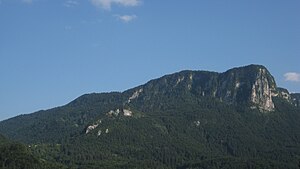
79:), originally known as Mount Kotlič, located on the southern part of the plateau, is its highest peak and reaches an elevation of 1,411 metres (4,629 ft). The northern part of the plateau has elevations up to 1,100 metres (3,600 ft).
258:
108:
287:
277:
297:
292:
178:
251:
121:(in Slovenian and English). Department of Geography, Faculty of Arts, University of Ljubljana. p. 9. Archived from
244:
282:
169:
122:
83:
115:
The
Geography of Jelovica with an Emphasis on the Possibilities of the Development of Tourism
82:
Iron ore was dug in
Jelovica in the past. During World War II, Jelovica was a refuge for the
72:
48:
20:
228:
271:
216:
87:
61:
149:(1:75,000 map). Vienna: Vienna: K. u. k. Militärgeographisches Institut. 1914.
193:
180:
110:
Geografija
Jelovice s poudarkom na možnostih razvoja turizma: diplomsko delo
164:
224:
57:
65:
26:
53:
232:
30:
Northern foot of
Jelovica, with the rocky Hag's Tooth (
86:. Nowadays, it is a protected area as part of the
252:
31:
8:
259:
245:
25:
99:
47:
7:
213:
211:
60:. It is the easternmost part of the
14:
215:
163:
19:For the village in Serbia, see
1:
231:. You can help Knowledge by
36:) visible at its right side
314:
288:Karst plateaus of Slovenia
278:Plateaus in Upper Carniola
210:
18:
298:Slovenia geography stubs
56:plateau in northwestern
293:Natura 2000 in Slovenia
227:geography article is a
76:
37:
32:
194:46.30139°N 14.13028°E
49:[jɛˈlɔːʋitsa]
29:
172:at Wikimedia Commons
107:Eržen, Saša (2007).
64:and is overgrown by
190: /
16:Plateau in Slovenia
199:46.30139; 14.13028
38:
240:
239:
168:Media related to
84:Slovene Partisans
305:
261:
254:
247:
219:
212:
205:
204:
202:
201:
200:
195:
191:
188:
187:
186:
183:
167:
151:
150:
143:
137:
136:
134:
133:
127:
120:
104:
51:
46:
35:
313:
312:
308:
307:
306:
304:
303:
302:
268:
267:
266:
265:
208:
198:
196:
192:
189:
184:
181:
179:
177:
176:
160:
155:
154:
145:
144:
140:
131:
129:
125:
118:
106:
105:
101:
96:
77:Partizanski vrh
71:Partisan Peak (
44:
24:
21:Jelovica, Pirot
17:
12:
11:
5:
311:
309:
301:
300:
295:
290:
285:
280:
270:
269:
264:
263:
256:
249:
241:
238:
237:
220:
174:
173:
159:
158:External links
156:
153:
152:
138:
98:
97:
95:
92:
15:
13:
10:
9:
6:
4:
3:
2:
310:
299:
296:
294:
291:
289:
286:
284:
281:
279:
276:
275:
273:
262:
257:
255:
250:
248:
243:
242:
236:
234:
230:
226:
221:
218:
214:
209:
206:
203:
171:
166:
162:
161:
157:
148:
142:
139:
128:on 2011-08-15
124:
116:
112:
111:
103:
100:
93:
91:
89:
85:
80:
78:
74:
69:
67:
63:
59:
55:
50:
42:
34:
28:
22:
233:expanding it
222:
207:
175:
147:Radmannsdorf
146:
141:
130:. Retrieved
123:the original
114:
109:
102:
81:
70:
40:
39:
283:Julian Alps
197: /
88:Natura 2000
62:Julian Alps
272:Categories
132:2012-04-05
94:References
45:pronounced
225:Slovenian
185:14°7′49″E
182:46°18′5″N
90:network.
33:Babji zob
170:Jelovica
68:forest.
58:Slovenia
41:Jelovica
73:Slovene
52:) is a
117:]
66:spruce
223:This
126:(PDF)
119:(PDF)
113:[
54:karst
229:stub
274::
75::
260:e
253:t
246:v
235:.
135:.
43:(
23:.
Text is available under the Creative Commons Attribution-ShareAlike License. Additional terms may apply.