326:
314:
48:
32:
55:
274:. In early 1979, a permanent pool of 2,000 acre-feet was established behind the dam for sediment control purposes "to decrease aggradation in the Rio Grande channel and thereby maintain or improve channel conveyance for Rio Grande Compact deliveries." In October of 1984, the pool was increased to 3,000 acre-feet.
277:
In 2001, the pool was gradually drained in order to deliver sediment directly downstream to the sediment-deficient Rio Grande and increase water availability. This caused a sharp reduction in recreation at the now dry reservoir, and in 2015, the area was closed to the public. Today, without sediment
297:
Today, the reservoir is left dry, and recreation is limited. There is no access to the dam or lakebed. All land surrounding the reservoir, including a small day-use area with picnic facilities and a scenic overlook, is the property of
735:
269:
Originally, the dam operated on a 48-hour hold regiment after storm events and during the spring runoff. This was to allow sediments to settle out of suspension before releasing the waters downstream into the
242:
for flood control and storm water management in the spring and early summer seasons. The dam is owned by the Corps of
Engineers, and operated by the Corps and the Cochiti Lake Project Office.
740:
488:
407:
745:
325:
313:
481:
375:
750:
47:
474:
516:
720:
251:
231:
151:
431:
350:
94:
725:
286:
The reservoir it creates, Jemez Canyon
Reservoir, has a normal water surface of 2.2 square miles and a maximum capacity of 264,700
290:. Recreation was historically high when there was a permanent pool of 2,000-3,000 acre feet due to its proximity to the growing
730:
497:
291:
259:
715:
653:
208:
82:
526:
456:
379:
521:
133:
628:
658:
618:
220:
638:
408:"ENVIRONMENTAL ASSESSMENT AND FINDING OF NO SIGNIFICANT IMPACT, Jemez Canyon Dam Recreation Area Closure"
643:
376:"Bureau of Reclamation - San Juan-Chama & Rio Grande Projects - Jemez Canyon Reservoir Fact Sheets"
633:
623:
531:
31:
587:
511:
435:
354:
299:
263:
679:
547:
227:
709:
694:
278:
control or recreation functions, the dam operates solely for flood-control purposes.
216:
129:
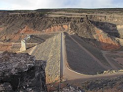
234:, with a height of 150 feet and a length at its crest of 870 feet. It impounds the
684:
648:
577:
466:
597:
592:
572:
567:
562:
552:
255:
235:
689:
674:
602:
271:
212:
109:
96:
557:
287:
188:
470:
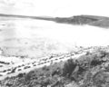
262:. Shortly after, in May-June 1958, high spring runoff in the
736:
Buildings and structures in
Bernalillo County, New Mexico
667:
611:
540:
504:
258:to protect farmland and property downstream in the
194:
183:
178:
170:
162:
157:
147:
139:
125:
88:
78:
70:
24:
319:Jemez Canyon Dam with a full reservoir in May 1958
302:. Access is restricted to the day-use area only.
741:Bodies of water of Bernalillo County, New Mexico
250:Jemez Canyon Dam was constructed in 1953 by the
331:People recreating at the reservoir in May 1958
482:
8:
746:United States Army Corps of Engineers dams
489:
475:
467:
266:filled the reservoir to 71,220 acre-feet.
62:Location of Jemez Canyon Dam in New Mexico
21:
402:
400:
398:
396:
54:
342:
309:
16:Dam in Sandoval County, New Mexico, USA
517:Middle Rio Grande Conservancy District
252:United States Army Corps of Engineers
232:United States Army Corps of Engineers
152:United States Army Corps of Engineers
7:
207:(National ID # NM00003) is a dam in
19:Dam in Sandoval County, New Mexico
14:
751:1953 establishments in New Mexico
324:
312:
53:
46:
30:
230:was constructed in 1953 by the
498:Rio Grande dams and diversions
198:2.2 square miles (5.7 km)
1:
292:Albuquerque metropolitan area
721:Dams in the Rio Grande basin
457:"Jemez Canyon Dam Reservoir"
254:to control flooding on the
83:Sandoval County, New Mexico
767:
522:Middle Rio Grande Project
41:
29:
726:Reservoirs in New Mexico
219:, a few miles north of
731:Dams completed in 1953
527:San Juan–Chama Project
240:Jemez Canyon Reservoir
110:35.39437°N 106.54702°W
174:870 feet (270 m)
532:Closed Basin Project
166:150 feet (46 m)
115:35.39437; -106.54702
184:Total capacity
106: /
716:Dams in New Mexico
512:Rio Grande Project
432:"Jemez Canyon Dam"
351:"Jemez Canyon Dam"
703:
702:
260:Rio Grande Valley
202:
201:
195:Surface area
158:Dam and spillways
140:Opening date
758:
668:Pecos River dams
491:
484:
477:
468:
461:
460:
453:
447:
446:
444:
443:
434:. Archived from
428:
422:
421:
419:
417:
412:
404:
391:
390:
388:
387:
378:. Archived from
372:
366:
365:
363:
362:
353:. Archived from
347:
328:
316:
300:Santa Ana Pueblo
205:Jemez Canyon Dam
134:water management
121:
120:
118:
117:
116:
111:
107:
104:
103:
102:
99:
57:
56:
50:
34:
25:Jemez Canyon Dam
22:
766:
765:
761:
760:
759:
757:
756:
755:
706:
705:
704:
699:
663:
607:
536:
500:
495:
465:
464:
455:
454:
450:
441:
439:
430:
429:
425:
415:
413:
410:
406:
405:
394:
385:
383:
374:
373:
369:
360:
358:
349:
348:
344:
339:
332:
329:
320:
317:
308:
284:
264:Jemez Mountains
248:
209:Sandoval County
114:
112:
108:
105:
100:
97:
95:
93:
92:
66:
65:
64:
63:
60:
59:
58:
37:
20:
17:
12:
11:
5:
764:
762:
754:
753:
748:
743:
738:
733:
728:
723:
718:
708:
707:
701:
700:
698:
697:
692:
687:
682:
680:Santa Rosa Dam
677:
671:
669:
665:
664:
662:
661:
656:
651:
646:
641:
636:
631:
626:
621:
615:
613:
612:Diversion dams
609:
608:
606:
605:
600:
595:
590:
588:Elephant Butte
585:
580:
575:
570:
565:
560:
555:
550:
544:
542:
538:
537:
535:
534:
529:
524:
519:
514:
508:
506:
502:
501:
496:
494:
493:
486:
479:
471:
463:
462:
448:
423:
392:
367:
341:
340:
338:
335:
334:
333:
330:
323:
321:
318:
311:
307:
304:
283:
280:
247:
244:
200:
199:
196:
192:
191:
185:
181:
180:
176:
175:
172:
168:
167:
164:
160:
159:
155:
154:
149:
145:
144:
141:
137:
136:
127:
123:
122:
90:
86:
85:
80:
76:
75:
72:
68:
67:
61:
52:
51:
45:
44:
43:
42:
39:
38:
35:
27:
26:
18:
15:
13:
10:
9:
6:
4:
3:
2:
763:
752:
749:
747:
744:
742:
739:
737:
734:
732:
729:
727:
724:
722:
719:
717:
714:
713:
711:
696:
695:Red Bluff Dam
693:
691:
688:
686:
683:
681:
678:
676:
673:
672:
670:
666:
660:
657:
655:
654:International
652:
650:
647:
645:
642:
640:
637:
635:
632:
630:
627:
625:
622:
620:
617:
616:
614:
610:
604:
601:
599:
596:
594:
591:
589:
586:
584:
581:
579:
576:
574:
571:
569:
566:
564:
561:
559:
556:
554:
551:
549:
546:
545:
543:
539:
533:
530:
528:
525:
523:
520:
518:
515:
513:
510:
509:
507:
503:
499:
492:
487:
485:
480:
478:
473:
472:
469:
458:
452:
449:
438:on 2012-10-12
437:
433:
427:
424:
409:
403:
401:
399:
397:
393:
382:on 2012-10-04
381:
377:
371:
368:
357:on 2012-10-12
356:
352:
346:
343:
336:
327:
322:
315:
310:
305:
303:
301:
295:
293:
289:
281:
279:
275:
273:
267:
265:
261:
257:
253:
245:
243:
241:
237:
233:
229:
224:
222:
218:
217:United States
214:
210:
206:
197:
193:
190:
186:
182:
177:
173:
169:
165:
161:
156:
153:
150:
146:
142:
138:
135:
131:
130:Flood control
128:
124:
119:
91:
87:
84:
81:
77:
74:United States
73:
69:
49:
40:
33:
28:
23:
685:Brantley Dam
583:Jemez Canyon
582:
541:Storage dams
451:
440:. Retrieved
436:the original
426:
414:. Retrieved
384:. Retrieved
380:the original
370:
359:. Retrieved
355:the original
345:
296:
285:
276:
268:
249:
239:
225:
204:
203:
256:Jemez River
236:Jemez River
228:earthen dam
221:Albuquerque
113: /
101:106°32′49″W
89:Coordinates
710:Categories
690:Avalon Dam
675:Sumner Dam
629:San Acacia
548:Rio Grande
442:2012-08-28
386:2012-08-28
361:2012-08-28
337:References
282:Recreation
272:Rio Grande
213:New Mexico
132:and storm
98:35°23′40″N
659:Riverside
619:Angostura
416:April 21,
288:acre-feet
238:creating
215:, in the
189:acre-feet
179:Reservoir
36:Jemez Dam
649:American
639:Leasburg
578:Galisteo
505:Projects
187:264,700
148:Owner(s)
79:Location
644:Mesilla
598:Amistad
593:Caballo
573:Cochiti
568:Abiquiu
563:El Vado
553:Platoro
306:Gallery
246:History
126:Purpose
71:Country
634:Percha
624:Isleta
603:Falcon
171:Length
163:Height
558:Heron
411:(PDF)
418:2024
226:The
143:1953
712::
395:^
294:.
223:.
211:,
490:e
483:t
476:v
459:.
445:.
420:.
389:.
364:.
Text is available under the Creative Commons Attribution-ShareAlike License. Additional terms may apply.