57:
39:
1469:
1459:
1449:
1439:
1429:
1419:
1409:
1399:
1389:
1379:
1369:
1359:
1349:
1344:
1334:
1324:
1314:
1304:
1294:
1284:
1274:
1264:
1254:
1249:
1239:
1229:
1208:
1188:
1183:
1168:
1158:
1148:
1138:
1128:
1123:
1113:
1108:
1098:
1093:
1083:
1073:
1063:
1053:
1043:
983:
973:
963:
645:
488:
238:
219:
695:
1198:
1178:
1013:
1003:
993:
1027:
78:
64:
436:
between
January and June 2020 due to bushfire damage and landslips from heavy rain and floods, and closure of the same section in March 2021 due to landslips and parts of the road washed away due to heavy rain and flooding. On May 25, 2021, the road was reopened at Hampton with Stop / Slow
419:
updated road classifications and the way they could be declared within New South Wales. Under this act, Jenolan Caves Road today retains its declaration as part of Main Road 253, from
Hartley to Jenolan Caves (and continuing northwest via Oberon to Bathurst).
825:
An Act to amend the Main Roads Act, 1924-1927; to confer certain further powers upon the MRB; to amend the Local
Government Act, 1919, and certain other Acts; to validate certain payments and other matters; and for purposes connected
937:
930:
848:
An Act to make provision with respect to the roads of New South Wales; to repeal the State Roads Act 1986, the Crown and Other Roads Act 1990 and certain other enactments; and for other purposes.
923:
380:
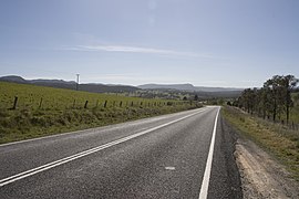
The road is fully sealed across its entire length. The road is as narrow as one lane on the 5-Mile, Grand Arch, and 2-Mile sections, but the majority of the road is two lanes wide.
56:
741:
1829:
872:
803:
An Act to provide for the better construction, maintenance, and financing of main roads; to provide for developmental roads; to constitute a Main Roads Board
996:
897:
138:
105:
851:
806:
1938:
2063:
1901:
1886:
1851:
1824:
1006:
829:
713:
1696:
1771:
428:
The road has been closed several times over the years due to bushfires and landslips. Two notable closures were the section between
779:
377:. From there it continues northwest on the 2-Mile section before turning into Edith Road at the Kanangra Walls Road intersection.
1916:
1721:
1731:
563:
499:
334:
357:
The road starts at the intersection of the Great
Western Highway and Blackmans Creek Road, then travels south and crosses the
1741:
412:
to provide for additional declarations of State
Highways and Trunk Roads, this was amended to Main Road 253 on 8 April 1929.
1876:
1746:
393:
38:
1911:
96:
1931:
1891:
1819:
1736:
1691:
1141:
634:
1392:
1191:
966:
1945:
1716:
653:
338:
1766:
1372:
622:
593:
572:
551:
542:
530:
495:
475:
429:
405:
369:
intersection. Next it winds south to the 5-Mile section which descends to the Grand Arch. It then goes through
346:
327:
323:
299:
295:
291:
273:
247:
2068:
1896:
1452:
700:
649:
608:
342:
1756:
1636:
584:
1786:
1711:
1706:
1671:
1568:
1076:
1066:
845:
708:
491:
401:
319:
241:
396:
provided for the declaration of Main Roads, roads partially funded by the State government through the
1986:
1976:
1906:
1881:
1796:
1781:
1593:
1533:
1498:
800:
437:
restrictions. The 5-Mile section was still closed. The 2-Mile section was reopened on May 10, 2021.
1761:
1686:
1603:
1442:
1287:
1151:
1131:
1101:
718:
400:(MRB). Main Road No. 253 was declared along this road on 8 August 1928, from the intersection with
374:
915:
2032:
1952:
1651:
1563:
1382:
1277:
1242:
2006:
1751:
1631:
1588:
1573:
1518:
1513:
1508:
1352:
1086:
986:
868:
207:
822:
408:) via Hampton to Jenolan Caves (and continuing northwest to Oberon); with the passing of the
2037:
1856:
1834:
1776:
1598:
1578:
1543:
1538:
1432:
1116:
1016:
397:
694:
1991:
1866:
1811:
1661:
1656:
1646:
1608:
1558:
1267:
1201:
1171:
1046:
947:
855:
833:
810:
525:
470:
311:
29:
2011:
1981:
1959:
1924:
1861:
1806:
1801:
1726:
1701:
1681:
1666:
1641:
1548:
1462:
1402:
1337:
1327:
1317:
1307:
1161:
1056:
771:
617:
604:
366:
362:
258:
194:
2057:
2001:
1871:
1791:
1676:
1472:
1412:
1257:
1211:
433:
370:
2042:
1996:
1841:
1528:
1503:
1297:
976:
673:
658:
Southwestern terminus of road, Tourist Route 1 continues northwest along Edith Road
778:. No. 110. National Library of Australia. 17 August 1928. pp. 3814–20.
2016:
1422:
746:
1846:
1583:
1523:
1488:
1362:
1232:
1026:
690:
509:
358:
153:
140:
120:
107:
1493:
898:"- Landslides close Jenolan Caves precinct again as terrible luck continues"
315:
919:
873:"Schedule of Classified Roads and Unclassified Regional Roads"
642:
485:
361:(Glenroy Bridge). From there it travels southwest and ascends
663:
1.000 mi = 1.609 km; 1.000 km = 0.621 mi
2025:
1969:
1617:
1481:
1220:
1034:
954:
287:
282:
264:
254:
231:
226:
213:
203:
193:
185:
177:
172:
95:
23:
776:Government Gazette of the State of New South Wales
657:
503:
333:The road is a part of Tourist Drive 1 linking the
931:
766:
764:
504:Northern terminus of road and Tourist Route 1
448:
8:
997:Pacific Motorway (Brisbane–Brunswick Heads)
938:
924:
916:
444:
37:
20:
648:Edith Road (Tourist Route 1) –
736:
734:
730:
365:, then continues to Hampton and to the
632:
626:
603:
597:
582:
576:
561:
555:
540:
534:
519:
513:
508:
479:
77:
63:
7:
1007:Pacific Motorway (Sydney–Newcastle)
714:List of highways in New South Wales
782:from the original on 3 August 2022
410:Main Roads (Amendment) Act of 1929
16:Road in New South Wales, Australia
14:
1467:
1457:
1447:
1437:
1427:
1417:
1407:
1397:
1387:
1377:
1367:
1357:
1347:
1342:
1332:
1322:
1312:
1302:
1292:
1282:
1272:
1262:
1252:
1247:
1237:
1227:
1206:
1196:
1186:
1181:
1176:
1166:
1156:
1146:
1136:
1126:
1121:
1111:
1106:
1096:
1091:
1081:
1071:
1061:
1051:
1041:
1025:
1011:
1001:
991:
981:
971:
961:
946:Road infrastructure in regional
693:
643:
486:
236:
217:
76:
62:
55:
878:. Government of New South Wales
562:Lowther Siding Road –
541:McKanes Falls Road –
373:and leads to a parking lot at
1:
394:Parliament of New South Wales
1697:Fitzgerald (Raymond Terrace)
2064:Highways in New South Wales
1142:Newcastle Inner City Bypass
900:. Oberon Review. March 2021
772:"Main Roads Act, 1924-1927"
635:Kanangra-Boyd National Park
46:Jenolan Caves Road, Hartley
2085:
846:State of New South Wales,
823:State of New South Wales,
801:State of New South Wales,
1939:Murrumbidgee (Carrathool)
1732:Hampden (Kangaroo Valley)
1023:
662:
638:
629:
621:
616:
612:
600:
592:
588:
579:
571:
567:
558:
550:
546:
537:
529:
524:
516:
482:
474:
469:
464:
461:
458:
455:
452:
447:
189:49.7 km (31 mi)
50:
45:
36:
1902:Williams (Clarence Town)
669:
583:Hampton Road –
274:Jenolan, New South Wales
248:Hartley, New South Wales
154:33.832835°S 149.998862°E
121:33.542435°S 150.167072°E
1453:Snowy Mountains Highway
701:Australian Roads portal
1877:Tea Gardens-Hawks Nest
854:11 August 2022 at the
832:12 August 2022 at the
809:11 August 2022 at the
633:Kanangra Walls Road –
390:Main Roads Act of 1924
159:-33.832835; 149.998862
126:-33.542435; 150.167072
1932:Hampden (Wagga Wagga)
1772:MacDonald (St Albans)
1692:Fitzgearld (Aberdeen)
1569:Murray Valley Highway
1077:Great Western Highway
1067:Central Coast Highway
709:Highways in Australia
492:Great Western Highway
402:Great Western Highway
320:Great Western Highway
242:Great Western Highway
1917:Yowaka (Greigs Flat)
1594:Solitary Islands Way
1534:Goulburn-Oberon Road
1499:Bathurst-Ilford Road
742:"Jenolan Caves Road"
166: (Southwest end)
133: (Northeast end)
1604:Wombeyan Caves Road
1443:Silver City Highway
1288:Castlereagh Highway
1152:Newcastle Link Road
1132:New England Highway
1102:Mid-Western Highway
441:Major intersections
415:The passing of the
388:The passing of the
375:Jenolan Caves House
310:is a rural road in
173:General information
150: /
117: /
1946:Old Cobram-Barooga
1767:Lennox (Glenbrook)
1564:Macleay Valley Way
1554:Jenolan Caves Road
1383:Lachlan Valley Way
1278:Burley Griffin Way
1243:Bells Line of Road
308:Jenolan Caves Road
25:Jenolan Caves Road
2051:
2050:
1970:Vehicular ferries
1897:Victoria (Picton)
1762:Karuah (Monkerai)
1589:Remembrance Drive
1519:Carnarvon Highway
1514:Camden Valley Way
1509:Bylong Valley Way
1353:Kamilaroi Highway
1087:Illawarra Highway
987:Hunter Expressway
869:Transport for NSW
684:
683:
494:(A32) –
417:Roads Act of 1993
326:to Edith Road at
305:
304:
288:Major settlements
208:Transport for NSW
2076:
1912:Wollombi (Bulga)
1624:(disused/former)
1599:Thunderbolts Way
1579:Old Hume Highway
1544:Henry Parkes Way
1539:Henry Lawson Way
1471:
1470:
1461:
1460:
1451:
1450:
1441:
1440:
1433:Riverina Highway
1431:
1430:
1421:
1420:
1411:
1410:
1401:
1400:
1391:
1390:
1381:
1380:
1371:
1370:
1361:
1360:
1351:
1350:
1346:
1345:
1336:
1335:
1326:
1325:
1316:
1315:
1306:
1305:
1296:
1295:
1286:
1285:
1276:
1275:
1266:
1265:
1256:
1255:
1251:
1250:
1241:
1240:
1231:
1230:
1210:
1209:
1200:
1199:
1190:
1189:
1185:
1184:
1180:
1179:
1170:
1169:
1160:
1159:
1150:
1149:
1140:
1139:
1130:
1129:
1125:
1124:
1117:Mitchell Highway
1115:
1114:
1110:
1109:
1100:
1099:
1095:
1094:
1085:
1084:
1075:
1074:
1065:
1064:
1055:
1054:
1045:
1044:
1029:
1017:Princes Motorway
1015:
1014:
1005:
1004:
995:
994:
985:
984:
975:
974:
965:
964:
940:
933:
926:
917:
910:
909:
907:
905:
894:
888:
887:
885:
883:
877:
865:
859:
858:10 November 1924
843:
837:
820:
814:
813:10 November 1924
798:
792:
791:
789:
787:
768:
759:
758:
756:
754:
738:
703:
698:
697:
677:
670:
647:
646:
490:
489:
450:
445:
398:Main Roads Board
278:
250:
240:
239:
221:
220:
165:
164:
162:
161:
160:
155:
151:
148:
147:
146:
143:
132:
131:
129:
128:
127:
122:
118:
115:
114:
113:
110:
80:
79:
66:
65:
59:
41:
21:
2084:
2083:
2079:
2078:
2077:
2075:
2074:
2073:
2054:
2053:
2052:
2047:
2021:
1965:
1637:Balun Bindarray
1622:
1621:
1620:
1619:
1613:
1609:Yass Valley Way
1559:Kosciuszko Road
1477:
1468:
1458:
1448:
1438:
1428:
1418:
1408:
1398:
1388:
1378:
1368:
1358:
1348:
1343:
1333:
1323:
1313:
1303:
1293:
1283:
1273:
1268:Bruxner Highway
1263:
1253:
1248:
1238:
1228:
1216:
1207:
1202:Princes Highway
1197:
1192:Pacific Highway
1187:
1182:
1177:
1172:Olympic Highway
1167:
1157:
1147:
1137:
1127:
1122:
1112:
1107:
1097:
1092:
1082:
1072:
1062:
1052:
1047:Barrier Highway
1042:
1030:
1021:
1012:
1002:
992:
982:
972:
967:Federal Highway
962:
950:
948:New South Wales
944:
914:
913:
903:
901:
896:
895:
891:
881:
879:
875:
871:(August 2022).
867:
866:
862:
856:Wayback Machine
844:
840:
834:Wayback Machine
821:
817:
811:Wayback Machine
799:
795:
785:
783:
770:
769:
762:
752:
750:
740:
739:
732:
727:
699:
692:
689:
680:
672:
668:
664:
644:
487:
443:
426:
386:
355:
312:New South Wales
272:
271:
246:
245:
237:
227:Major junctions
222:Tourist Route 1
218:
158:
156:
152:
149:
144:
141:
139:
137:
136:
125:
123:
119:
116:
111:
108:
106:
104:
103:
91:
90:
89:
88:
87:
86:
85:
81:
73:
72:
71:
67:
32:
30:New South Wales
27:
26:
17:
12:
11:
5:
2082:
2080:
2072:
2071:
2069:Oberon Council
2066:
2056:
2055:
2049:
2048:
2046:
2045:
2040:
2035:
2029:
2027:
2023:
2022:
2020:
2019:
2014:
2009:
2004:
1999:
1994:
1989:
1987:Lower Portland
1984:
1979:
1977:Berowra Waters
1973:
1971:
1967:
1966:
1964:
1963:
1956:
1949:
1942:
1935:
1928:
1920:
1919:
1914:
1909:
1904:
1899:
1894:
1889:
1884:
1879:
1874:
1869:
1864:
1859:
1854:
1849:
1844:
1839:
1838:
1837:
1832:
1827:
1822:
1814:
1809:
1804:
1799:
1794:
1789:
1787:Macleay Valley
1784:
1779:
1774:
1769:
1764:
1759:
1754:
1749:
1744:
1739:
1734:
1729:
1724:
1719:
1714:
1709:
1707:George Chaffey
1704:
1699:
1694:
1689:
1684:
1679:
1674:
1672:Crankies Plain
1669:
1664:
1659:
1654:
1649:
1644:
1639:
1634:
1628:
1626:
1615:
1614:
1612:
1611:
1606:
1601:
1596:
1591:
1586:
1581:
1576:
1574:O'Connell Road
1571:
1566:
1561:
1556:
1551:
1549:Irrigation Way
1546:
1541:
1536:
1531:
1526:
1521:
1516:
1511:
1506:
1501:
1496:
1491:
1485:
1483:
1479:
1478:
1476:
1475:
1465:
1463:Summerland Way
1455:
1445:
1435:
1425:
1415:
1405:
1403:Monaro Highway
1395:
1393:Memorial Drive
1385:
1375:
1365:
1355:
1340:
1338:Gwydir Highway
1330:
1328:Goldfields Way
1320:
1318:Golden Highway
1310:
1308:Fossickers Way
1300:
1290:
1280:
1270:
1260:
1245:
1235:
1224:
1222:
1221:Minor highways
1218:
1217:
1215:
1214:
1204:
1194:
1174:
1164:
1162:Newell Highway
1154:
1144:
1134:
1119:
1104:
1089:
1079:
1069:
1059:
1057:Barton Highway
1049:
1038:
1036:
1035:Major highways
1032:
1031:
1024:
1022:
1020:
1019:
1009:
999:
989:
979:
969:
958:
956:
952:
951:
945:
943:
942:
935:
928:
920:
912:
911:
889:
860:
838:
815:
793:
760:
729:
728:
726:
723:
722:
721:
716:
711:
705:
704:
688:
685:
682:
681:
679:
678:
665:
660:
659:
656:
640:
639:
637:
631:
628:
625:
620:
614:
613:
611:
605:Duckmaloi Road
602:
599:
596:
590:
589:
587:
581:
578:
575:
569:
568:
566:
564:Little Hartley
560:
557:
554:
548:
547:
545:
539:
536:
533:
528:
522:
521:
520:Glenroy Bridge
518:
515:
512:
506:
505:
502:
500:Mount Victoria
484:
481:
478:
473:
467:
466:
463:
460:
457:
454:
451:
442:
439:
425:
422:
385:
382:
367:Duckmaloi Road
363:Mount Blaxland
354:
351:
335:Blue Mountains
303:
302:
289:
285:
284:
280:
279:
266:
262:
261:
259:Duckmaloi Road
256:
252:
251:
233:
229:
228:
224:
223:
215:
214:Tourist routes
211:
210:
205:
201:
200:
197:
191:
190:
187:
183:
182:
179:
175:
174:
170:
169:
168:
167:
134:
99:
93:
92:
83:
82:
75:
74:
69:
68:
61:
60:
54:
53:
52:
51:
48:
47:
43:
42:
34:
33:
28:
24:
15:
13:
10:
9:
6:
4:
3:
2:
2081:
2070:
2067:
2065:
2062:
2061:
2059:
2044:
2041:
2039:
2036:
2034:
2031:
2030:
2028:
2024:
2018:
2015:
2013:
2010:
2008:
2005:
2003:
2000:
1998:
1995:
1993:
1990:
1988:
1985:
1983:
1980:
1978:
1975:
1974:
1972:
1968:
1962:
1961:
1957:
1955:
1954:
1950:
1948:
1947:
1943:
1941:
1940:
1936:
1934:
1933:
1929:
1927:
1926:
1922:
1921:
1918:
1915:
1913:
1910:
1908:
1907:Wallaby Rocks
1905:
1903:
1900:
1898:
1895:
1893:
1890:
1888:
1885:
1883:
1882:Tourle Street
1880:
1878:
1875:
1873:
1870:
1868:
1865:
1863:
1860:
1858:
1855:
1853:
1850:
1848:
1845:
1843:
1840:
1836:
1833:
1831:
1828:
1826:
1823:
1821:
1818:
1817:
1815:
1813:
1810:
1808:
1805:
1803:
1800:
1798:
1797:Mooney Mooney
1795:
1793:
1790:
1788:
1785:
1783:
1782:McKanes Falls
1780:
1778:
1775:
1773:
1770:
1768:
1765:
1763:
1760:
1758:
1755:
1753:
1750:
1748:
1745:
1743:
1740:
1738:
1735:
1733:
1730:
1728:
1725:
1723:
1720:
1718:
1715:
1713:
1710:
1708:
1705:
1703:
1700:
1698:
1695:
1693:
1690:
1688:
1685:
1683:
1680:
1678:
1675:
1673:
1670:
1668:
1665:
1663:
1660:
1658:
1655:
1653:
1650:
1648:
1645:
1643:
1640:
1638:
1635:
1633:
1630:
1629:
1627:
1625:
1616:
1610:
1607:
1605:
1602:
1600:
1597:
1595:
1592:
1590:
1587:
1585:
1582:
1580:
1577:
1575:
1572:
1570:
1567:
1565:
1562:
1560:
1557:
1555:
1552:
1550:
1547:
1545:
1542:
1540:
1537:
1535:
1532:
1530:
1527:
1525:
1522:
1520:
1517:
1515:
1512:
1510:
1507:
1505:
1502:
1500:
1497:
1495:
1492:
1490:
1487:
1486:
1484:
1480:
1474:
1473:Waterfall Way
1466:
1464:
1456:
1454:
1446:
1444:
1436:
1434:
1426:
1424:
1416:
1414:
1413:Oxley Highway
1406:
1404:
1396:
1394:
1386:
1384:
1376:
1374:
1373:Kings Highway
1366:
1364:
1356:
1354:
1341:
1339:
1331:
1329:
1321:
1319:
1311:
1309:
1301:
1299:
1291:
1289:
1281:
1279:
1271:
1269:
1261:
1259:
1258:Big River Way
1246:
1244:
1236:
1234:
1226:
1225:
1223:
1219:
1213:
1212:Sturt Highway
1205:
1203:
1195:
1193:
1175:
1173:
1165:
1163:
1155:
1153:
1145:
1143:
1135:
1133:
1120:
1118:
1105:
1103:
1090:
1088:
1080:
1078:
1070:
1068:
1060:
1058:
1050:
1048:
1040:
1039:
1037:
1033:
1028:
1018:
1010:
1008:
1000:
998:
990:
988:
980:
978:
970:
968:
960:
959:
957:
953:
949:
941:
936:
934:
929:
927:
922:
921:
918:
899:
893:
890:
874:
870:
864:
861:
857:
853:
850:
849:
842:
839:
835:
831:
828:
827:
819:
816:
812:
808:
805:
804:
797:
794:
781:
777:
773:
767:
765:
761:
749:
748:
743:
737:
735:
731:
724:
720:
717:
715:
712:
710:
707:
706:
702:
696:
691:
686:
675:
667:
666:
661:
655:
651:
641:
636:
624:
619:
615:
610:
606:
595:
591:
586:
574:
570:
565:
553:
549:
544:
532:
527:
523:
511:
507:
501:
497:
493:
477:
472:
468:
446:
440:
438:
435:
434:Jenolan Caves
431:
423:
421:
418:
413:
411:
407:
403:
399:
395:
391:
383:
381:
378:
376:
372:
371:Jenolan Caves
368:
364:
360:
352:
350:
348:
344:
340:
336:
331:
329:
325:
321:
317:
313:
309:
301:
297:
293:
290:
286:
281:
277:
275:
270:
267:
265:Southwest end
263:
260:
257:
253:
249:
244:
243:
234:
232:Northeast end
230:
225:
216:
212:
209:
206:
204:Maintained by
202:
198:
196:
192:
188:
184:
180:
176:
171:
163:
135:
130:
102:
101:
100:
98:
94:
84:Southwest end
70:Northeast end
58:
49:
44:
40:
35:
31:
22:
19:
2043:Tugun Bypass
1958:
1951:
1944:
1937:
1930:
1923:
1717:Goodradigbee
1687:The Entrance
1623:
1618:Road bridges
1553:
1529:Giinagay Way
1504:Bucketts Way
1298:Cobb Highway
977:Hume Highway
902:. Retrieved
892:
880:. Retrieved
863:
847:
841:
836:8 April 1929
824:
818:
802:
796:
784:. Retrieved
775:
751:. Retrieved
745:
671:
607: –
462:Destinations
427:
416:
414:
409:
392:through the
389:
387:
379:
356:
332:
307:
306:
276:
268:
235:
18:
2007:Webbs Creek
1953:Old Mildura
1652:Bland Creek
1482:Other roads
1423:Picton Road
747:Google Maps
283:Location(s)
199:August 1928
157: /
145:149°59′56″E
124: /
112:150°10′01″E
97:Coordinates
2058:Categories
1752:Holt-Bragg
1632:Abbotsford
1584:Putty Road
1524:Escort Way
1489:Alpine Way
1363:Kidman Way
1233:Appin Road
826:therewith.
725:References
719:Fish River
676:transition
510:Coxs River
359:Coxs River
318:, linking
269:Edith Road
181:Rural road
142:33°49′58″S
109:33°32′33″S
2038:St Helena
1992:Sackville
1857:Sea Cliff
1835:Tooleybuc
1825:Swan Hill
1777:McFarlane
1494:Barry Way
955:Motorways
316:Australia
2012:Wisemans
1982:Lawrence
1867:Stockton
1830:Tocumwal
1812:Mungindi
1757:Junction
1712:Glennies
1662:Coonamit
1657:Colemans
1647:Bethanga
882:1 August
852:Archived
830:Archived
807:Archived
786:1 August
780:Archived
687:See also
654:Bathurst
453:Location
424:Closures
339:Bathurst
195:Gazetted
2026:Tunnels
2002:Ulmarra
1960:Thornes
1925:Denison
1887:Towamba
1862:Sheahan
1816:Murray
1807:Mulwala
1802:Morpeth
1727:Harwood
1722:Grafton
1702:Gee Gee
1682:Dunmore
1667:Cooreei
1642:Beckers
753:16 June
744:(Map).
623:Jenolan
594:Hampton
573:Hampton
552:Lowther
543:Lithgow
531:Hartley
526:Lithgow
496:Lithgow
476:Hartley
471:Lithgow
430:Hampton
406:Hartley
384:History
347:Hampton
328:Jenolan
324:Hartley
300:Jenolan
296:Hampton
292:Lowther
2033:Cudgen
1997:Speewa
1872:Taemas
1820:Barham
1792:Martin
1747:Hinton
1742:Hexham
1677:Dennis
650:Oberon
618:Oberon
609:Oberon
343:Oberon
255:
186:Length
2017:Wymah
1852:Rossi
1842:Nowra
904:3 May
876:(PDF)
674:Route
585:Rydal
465:Notes
353:Route
1892:Vacy
906:2021
884:2022
788:2022
755:2023
630:30.9
627:49.7
601:14.7
598:23.7
580:12.1
577:19.4
556:12.2
432:and
345:and
341:via
178:Type
1847:Rip
1737:Hay
559:7.6
538:3.9
535:6.2
517:1.3
514:2.1
483:0.0
480:0.0
449:LGA
404:at
337:to
322:at
2060::
774:.
763:^
733:^
652:,
498:,
459:mi
456:km
349:.
330:.
314:,
298:,
294:,
939:e
932:t
925:v
908:.
886:.
790:.
757:.
Text is available under the Creative Commons Attribution-ShareAlike License. Additional terms may apply.