71:
101:
368:
108:
78:
42:
321:
Construction of the dam started on June 27, 1987, and was completed on April 12, 1993. Jordanelle State Park opened on June 29, 1995. Construction of the dam was challenged by several groups.
1373:
675:
634:
1134:
1164:
352:
and runners alike. Because of the State Park's rugged terrain on the Rock Cliff side, sponsors host sprint triathlons in addition to 10-kilometre (6.2 mi) races and ultra
1388:
523:
1378:
838:
853:
1124:
553:
810:
153:
100:
70:
981:
544:
1368:
1039:
1031:
660:
1288:
815:
787:
642:
516:
473:
1403:
1293:
1283:
1201:
665:
532:
457:
721:
1114:
381:
746:
1109:
624:
614:
591:
325:
wanted to maintain the natural state of the Provo River. Because of this, a large area at the foot of the dam was converted into an
736:
1273:
782:
619:
509:
1393:
986:
871:
708:
698:
996:
876:
792:
599:
481:
1398:
1363:
1144:
1094:
1089:
906:
901:
833:
756:
1358:
1308:
1278:
1236:
1174:
1084:
976:
926:
886:
825:
609:
443:
1119:
1001:
891:
866:
843:
802:
604:
576:
566:
1268:
951:
896:
571:
1256:
1206:
1189:
1067:
911:
861:
774:
764:
741:
731:
652:
421:
386:
936:
407:
1006:
931:
329:. Other groups were concerned that the site was geologically flawed, citing the catastrophic failure of the
1333:
1328:
1323:
1211:
1099:
961:
946:
941:
916:
716:
298:
55:
1383:
1313:
1298:
1241:
1216:
1011:
921:
881:
726:
322:
294:
211:
51:
1169:
1159:
1149:
1016:
991:
971:
956:
561:
301:(which now run concurrently over the summit of nearby mountains) and the submergence of the towns of
271:
133:
1226:
1221:
342:
326:
1303:
1231:
1154:
1058:
693:
581:
486:
197:
966:
1318:
1129:
683:
310:
275:
47:
1246:
1104:
1079:
1021:
496:
373:
338:
306:
467:
225:
1352:
302:
255:
185:
17:
1044:
688:
1179:
462:
432:
408:
U.S. Geological Survey
Geographic Names Information System: Jordanelle Reservoir
349:
290:
282:
218:
204:
363:
168:
155:
353:
341:
were also concerned, fearing that the reservoir would flood sections of the
330:
267:
190:
501:
198:
41:
212:
334:
293:. The construction of the dam resulted in the reroutings of both
536:
137:
505:
348:
During the summer months, Jordanelle is a destination for
281:
Jordanelle
Reservoir is fed and drained primarily by the
46:
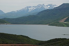
Looking southwest across the
Jordanelle Reservoir, with
417:
415:
1255:
1188:
1066:
1057:
1030:
852:
824:
801:
773:
755:
707:
674:
651:
633:
590:
552:
543:
251:
247:
239:
235:
224:
210:
196:
184:
145:
129:
34:
1374:Buildings and structures in Wasatch County, Utah
146:
517:
27:Reservoir in the state of Utah, United States
8:
458:Blue Ribbon Fisheries - Jordanelle Reservoir
107:
77:
1063:
549:
524:
510:
502:
31:
1389:United States Bureau of Reclamation dams
1379:Protected areas of Wasatch County, Utah
397:
403:
401:
7:
337:in 1976. Mining interests in nearby
382:List of dams and reservoirs in Utah
25:
1125:Historic Union Pacific Rail Trail
783:Bear River Migratory Bird Refuge
366:
106:
99:
76:
69:
58:road cut on the right, June 2006
40:
274:, United States, just north of
238:
482:Utah Division of Water Quality
1:
1369:Lakes of Wasatch County, Utah
982:Paria Canyon-Vermilion Cliffs
128:
120:Show map of the United States
1404:1992 establishments in Utah
803:National Conservation Areas
1420:
1289:Escalante Petrified Forest
844:Jurassic National Monument
285:, and is impounded by the
839:Grand Staircase–Escalante
775:National Wildlife Refuges
653:National Recreation Areas
243:6,188 feet (1,886 m)
63:
39:
1115:Fred Hayes at Starvation
765:Desert Biosphere Reserve
676:National Historic Trails
387:List of Utah State Parks
50:in the distance and the
635:National Historic Parks
497:Jordanelle Fishing Info
468:Utah Outdoor Activities
1394:Dams completed in 1992
1237:Territorial Statehouse
1032:Wild and Scenic Rivers
826:BLM National Monuments
592:NPS National Monuments
474:"Jordanelle Reservoir"
169:40.61667°N 111.40833°W
1274:Coral Pink Sand Dunes
1135:Jordan River OHV Park
854:U.S. Wilderness Areas
492:on February 27, 2014.
463:Jordanelle State Park
444:Utah Outdoors website
317:Jordanelle State Park
18:Jordanelle State Park
1399:Constructed wetlands
987:Pine Valley Mountain
872:Beaver Dam Mountains
757:Forest Service areas
272:Wasatch County, Utah
264:Jordanelle Reservoir
174:40.61667; -111.40833
114:Jordanelle Reservoir
84:Jordanelle Reservoir
35:Jordanelle Reservoir
1364:State parks of Utah
1017:Wellsville Mountain
877:Black Ridge Canyons
747:Uinta–Wasatch–Cache
433:State Parks website
343:Ontario silver mine
165: /
1359:Reservoirs in Utah
1294:Frontier Homestead
1284:Edge of the Cedars
422:Utah History to Go
327:artificial wetland
1346:
1345:
1342:
1341:
1053:
1052:
907:Cottonwood Forest
902:Cottonwood Canyon
261:
260:
240:Surface elevation
16:(Redirected from
1411:
1309:Kodachrome Basin
1279:Dead Horse Point
1262:
1195:
1175:Wasatch Mountain
1165:Utah Field House
1073:
1064:
977:Mount Timpanogos
927:Deep Creek North
887:Box-Death Hollow
709:National Forests
550:
526:
519:
512:
503:
493:
491:
485:. Archived from
478:
446:
441:
435:
430:
424:
419:
410:
405:
376:
371:
370:
369:
323:Conservationists
214:
213:Primary outflows
200:
180:
179:
177:
176:
175:
170:
166:
163:
162:
161:
158:
148:
121:
110:
109:
103:
91:
90:Show map of Utah
80:
79:
73:
48:Mount Timpanogos
44:
32:
21:
1419:
1418:
1414:
1413:
1412:
1410:
1409:
1408:
1349:
1348:
1347:
1338:
1261:Southern Region
1260:
1259:
1251:
1193:
1192:
1184:
1120:Great Salt Lake
1080:Antelope Island
1072:Northern Region
1071:
1070:
1049:
1026:
1002:Slaughter Creek
892:Canaan Mountain
867:Beartrap Canyon
848:
820:
811:Beaver Dam Wash
797:
769:
751:
722:Caribou–Targhee
703:
670:
647:
629:
625:Timpanogos Cave
615:Natural Bridges
586:
539:
533:Protected areas
530:
489:
476:
472:
454:
449:
442:
438:
431:
427:
420:
413:
406:
399:
395:
374:Wetlands portal
372:
367:
365:
362:
319:
228: countries
199:Primary inflows
173:
171:
167:
164:
159:
156:
154:
152:
151:
140:
125:
124:
123:
122:
119:
118:
117:
116:
115:
111:
94:
93:
92:
89:
88:
87:
86:
85:
81:
59:
28:
23:
22:
15:
12:
11:
5:
1417:
1415:
1407:
1406:
1401:
1396:
1391:
1386:
1381:
1376:
1371:
1366:
1361:
1351:
1350:
1344:
1343:
1340:
1339:
1337:
1336:
1331:
1326:
1321:
1316:
1311:
1306:
1301:
1296:
1291:
1286:
1281:
1276:
1271:
1265:
1263:
1253:
1252:
1250:
1249:
1244:
1239:
1234:
1229:
1224:
1219:
1214:
1209:
1204:
1202:Fremont Indian
1198:
1196:
1194:Central Region
1186:
1185:
1183:
1182:
1177:
1172:
1167:
1162:
1157:
1152:
1147:
1142:
1137:
1132:
1127:
1122:
1117:
1112:
1107:
1102:
1097:
1092:
1087:
1082:
1076:
1074:
1061:
1055:
1054:
1051:
1050:
1048:
1047:
1042:
1036:
1034:
1028:
1027:
1025:
1024:
1019:
1014:
1009:
1004:
999:
994:
989:
984:
979:
974:
969:
964:
959:
954:
952:LaVerkin Creek
949:
944:
939:
934:
929:
924:
919:
914:
909:
904:
899:
897:Cedar Mountain
894:
889:
884:
879:
874:
869:
864:
858:
856:
850:
849:
847:
846:
841:
836:
830:
828:
822:
821:
819:
818:
813:
807:
805:
799:
798:
796:
795:
790:
785:
779:
777:
771:
770:
768:
767:
761:
759:
753:
752:
750:
749:
744:
739:
734:
729:
724:
719:
713:
711:
705:
704:
702:
701:
696:
691:
689:Mormon Pioneer
686:
680:
678:
672:
671:
669:
668:
663:
657:
655:
649:
648:
646:
645:
639:
637:
631:
630:
628:
627:
622:
620:Rainbow Bridge
617:
612:
607:
602:
596:
594:
588:
587:
585:
584:
579:
574:
569:
564:
558:
556:
554:National Parks
547:
541:
540:
531:
529:
528:
521:
514:
506:
500:
499:
494:
470:
465:
460:
453:
452:External links
450:
448:
447:
436:
425:
411:
396:
394:
391:
390:
389:
384:
378:
377:
361:
358:
318:
315:
299:U.S. Route 189
287:Jordanelle Dam
259:
258:
253:
249:
248:
245:
244:
241:
237:
236:
233:
232:
229:
222:
221:
216:
208:
207:
202:
194:
193:
188:
182:
181:
149:
143:
142:
134:Wasatch County
131:
127:
126:
113:
112:
105:
104:
98:
97:
96:
95:
83:
82:
75:
74:
68:
67:
66:
65:
64:
61:
60:
45:
37:
36:
26:
24:
14:
13:
10:
9:
6:
4:
3:
2:
1416:
1405:
1402:
1400:
1397:
1395:
1392:
1390:
1387:
1385:
1382:
1380:
1377:
1375:
1372:
1370:
1367:
1365:
1362:
1360:
1357:
1356:
1354:
1335:
1332:
1330:
1327:
1325:
1322:
1320:
1317:
1315:
1312:
1310:
1307:
1305:
1302:
1300:
1297:
1295:
1292:
1290:
1287:
1285:
1282:
1280:
1277:
1275:
1272:
1270:
1267:
1266:
1264:
1258:
1254:
1248:
1245:
1243:
1240:
1238:
1235:
1233:
1230:
1228:
1225:
1223:
1220:
1218:
1215:
1213:
1210:
1208:
1207:Goblin Valley
1205:
1203:
1200:
1199:
1197:
1191:
1187:
1181:
1178:
1176:
1173:
1171:
1168:
1166:
1163:
1161:
1158:
1156:
1153:
1151:
1148:
1146:
1143:
1141:
1138:
1136:
1133:
1131:
1128:
1126:
1123:
1121:
1118:
1116:
1113:
1111:
1108:
1106:
1103:
1101:
1098:
1096:
1093:
1091:
1088:
1086:
1083:
1081:
1078:
1077:
1075:
1069:
1065:
1062:
1060:
1056:
1046:
1043:
1041:
1038:
1037:
1035:
1033:
1029:
1023:
1020:
1018:
1015:
1013:
1010:
1008:
1005:
1003:
1000:
998:
997:Red Mountains
995:
993:
990:
988:
985:
983:
980:
978:
975:
973:
972:Mount Olympus
970:
968:
965:
963:
960:
958:
955:
953:
950:
948:
945:
943:
940:
938:
935:
933:
930:
928:
925:
923:
920:
918:
915:
913:
912:Cougar Canyon
910:
908:
905:
903:
900:
898:
895:
893:
890:
888:
885:
883:
880:
878:
875:
873:
870:
868:
865:
863:
862:Ashdown Gorge
860:
859:
857:
855:
851:
845:
842:
840:
837:
835:
832:
831:
829:
827:
823:
817:
814:
812:
809:
808:
806:
804:
800:
794:
791:
789:
786:
784:
781:
780:
778:
776:
772:
766:
763:
762:
760:
758:
754:
748:
745:
743:
740:
738:
735:
733:
730:
728:
725:
723:
720:
718:
715:
714:
712:
710:
706:
700:
697:
695:
692:
690:
687:
685:
682:
681:
679:
677:
673:
667:
664:
662:
661:Flaming Gorge
659:
658:
656:
654:
650:
644:
641:
640:
638:
636:
632:
626:
623:
621:
618:
616:
613:
611:
608:
606:
603:
601:
598:
597:
595:
593:
589:
583:
580:
578:
575:
573:
570:
568:
565:
563:
560:
559:
557:
555:
551:
548:
546:
542:
538:
534:
527:
522:
520:
515:
513:
508:
507:
504:
498:
495:
488:
484:
483:
475:
471:
469:
466:
464:
461:
459:
456:
455:
451:
445:
440:
437:
434:
429:
426:
423:
418:
416:
412:
409:
404:
402:
398:
392:
388:
385:
383:
380:
379:
375:
364:
359:
357:
355:
351:
346:
344:
340:
336:
332:
328:
324:
316:
314:
312:
308:
304:
300:
296:
295:U.S. Route 40
292:
288:
284:
279:
277:
273:
269:
265:
257:
254:
250:
246:
242:
234:
231:United States
230:
227:
223:
220:
217:
215:
209:
206:
203:
201:
195:
192:
189:
187:
183:
178:
150:
144:
141:United States
139:
135:
132:
102:
72:
62:
57:
53:
49:
43:
38:
33:
30:
19:
1384:Dams in Utah
1139:
1045:Virgin River
1007:Taylor Creek
932:Deseret Peak
788:Fish Springs
737:Manti–La Sal
694:Pony Express
643:Golden Spike
600:Cedar Breaks
577:Capitol Reef
567:Bryce Canyon
487:the original
480:
439:
428:
347:
320:
286:
280:
263:
262:
29:
1334:Snow Canyon
1329:Sand Hollow
1324:Quail Creek
1314:Otter Creek
1257:State Parks
1212:Green River
1190:State Parks
1180:Willard Bay
1110:Flight Park
1100:East Canyon
1068:State Parks
1040:Green River
962:Mount Naomi
947:High Uintas
942:Goose Creek
917:Dark Canyon
699:Old Spanish
666:Glen Canyon
572:Canyonlands
350:triathletes
291:earthen dam
283:Provo River
252:Settlements
219:Provo River
205:Provo River
172: /
160:111°24′30″W
147:Coordinates
1353:Categories
1299:Goosenecks
1242:Utahraptor
1217:Huntington
1145:Lost Creek
1140:Jordanelle
1095:Deer Creek
1090:Camp Floyd
1012:Twin Peaks
967:Mount Nebo
937:Doc's Pass
922:Deep Creek
882:Blackridge
834:Bears Ears
816:Red Cliffs
684:California
393:References
311:Jordanelle
276:Heber City
1170:Utah Lake
1160:Steinaker
1150:Red Fleet
1085:Bear Lake
992:Red Butte
957:Lone Peak
610:Hovenweep
354:marathons
339:Park City
331:Teton Dam
307:Hailstone
268:reservoir
191:reservoir
157:40°37′0″N
1232:Scofield
1227:Palisade
1222:Millsite
1155:Rockport
742:Sawtooth
732:Fishlake
605:Dinosaur
360:See also
130:Location
1304:Gunlock
1269:Anasazi
545:Federal
303:Keetley
256:Hideout
717:Ashley
562:Arches
309:, and
56:US-189
1319:Piute
1130:Hyrum
1059:State
793:Ouray
727:Dixie
490:(PDF)
477:(PDF)
335:Idaho
289:, an
266:is a
226:Basin
52:US-40
1247:Yuba
1105:Echo
1022:Zion
582:Zion
537:Utah
297:and
186:Type
138:Utah
535:of
333:in
270:in
1355::
479:.
414:^
400:^
356:.
345:.
313:.
305:,
278:.
136:,
525:e
518:t
511:v
54:/
20:)
Text is available under the Creative Commons Attribution-ShareAlike License. Additional terms may apply.