279:
115:
85:
290:
338:
55:
34:
122:
92:
62:
297:
The Bay is approximately 8 mi (13 km) long and 2.7 mi (4.3 km) wide, with a mouth opening of about 4.6 mi (7.4 km) wide and a maximum depth of 40 ft (12 m) in the dredged channel. It has one of the two
353:
within Kāneʻohe Bay. A sand bar (Ahu o Laka), Kapapa, and Kekepa (Turtleback Rock) are all islets on the barrier reef. Two islands within Kāneʻohe Bay are prominent:
322:
dredged the length of the lagoon between 1939 and 1945. The lagoon contains extensive patch and fringing reefs and its southern end is partly enclosed by the
394:
114:
159:
84:
480:
555:
241:
372:
Coconut Island is an isolated volcanic remnant located in the southwest part of the bay. Coconut Island is owned by the state of
310:. Two navigable channels cut across the northern and southern ends of the barrier reef. The deeper, northern channel, located off
585:
532:
510:
54:
358:
39:
580:
575:
278:
331:
361:), the largest of the five. Mokoliʻi is a volcanic remnant at the very north end of the Bay, site of former
293:
The bay seen on a clear morning from Heeia Kea Small Boat Harbor Marina pier looking north towards Mokoli'i
570:
385:
377:
311:
267:
constitutes a significant scenic and recreational feature along the northeast coast of the Island of
319:
418:
381:
380:, and Pauley-Pagen Laboratory (SOEST). Coconut Island was used for the opening sequence of the
323:
256:
366:
362:
289:
272:
38:
Kāneʻohe Bay on a calm morning viewed from the
Kokokahi YWCA at the south end of the bay.
255:, at 45 km (17 sq mi), is the largest sheltered body of water in the main
337:
564:
540:
315:
191:
458:
402:
302:
in the archipelago, the other being the 27 mi (43 km) barrier reef of
299:
174:
161:
406:
327:
306:, and also has extensive development of shoaling coral reefs within a large
264:
341:
Koʻolau
Mountain Range seen on a clear morning from Kaneʻohe Bay on a boat
33:
354:
303:
282:
373:
346:
307:
409:
into the
Pacific Ocean, leaving behind only the Range and the Bay.
350:
336:
288:
277:
401:
Geologically, Kāneʻohe Bay forms part of a former caldera of the
268:
260:
271:. The largest population center on Kāneʻohe Bay is the town of
526:
511:"Jokiel's Illustrated Scientific Guide to Kāneʻohe Bay, Oʻahu"
438:
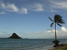
285:, a prominent island at the northern edge of Kāneʻohe Bay
16:
Large bay of volcanic origin in the
Hawaiian island O'ahu
405:. In prehistory, most of the volcano catalysmically
240:
236:
228:
220:
212:
204:
200:
190:
151:
143:
21:
152:
365:. The community on the northern side is called
8:
459:"Kayaking and Snorkeling: He'eia State Park"
395:Pirates of the Caribbean: On Stranger Tides
18:
533:"Kaneohe Bay... Going Back to Old Hawaii"
430:
42:appears in the middle of this picture.
439:"Hawaiʻi Institute of Marine Biology"
7:
485:draws crowds to Kaneohe Bay, Hawaii"
121:
91:
61:
314:, provides entrance from the North
14:
120:
113:
90:
83:
60:
53:
32:
227:
224:45 km (17 sq mi)
219:
211:
203:
556:Anchoring at Kāne‘ohe Sand Bar
1:
537:Hawaii Beach Combers web site
142:
602:
483:Pirates of the Caribbean 4
216:2.7 mi (4.3 km)
134:Show map of Pacific Ocean
47:
31:
26:
461:. He'eia Learning Center
369:, or North Koʻolaupoko.
332:Marine Corps Base Hawaii
586:Bodies of water of Oahu
398:was filmed on the bay.
342:
294:
286:
232:40 ft (12 m)
208:8 mi (13 km)
175:21.46278°N 157.81028°W
378:University of Hawaiʻi
345:There are five named
340:
292:
281:
312:Kualoa Regional Park
180:21.46278; -157.81028
171: /
581:Submarine calderas
419:Kamehameha Highway
382:television program
343:
295:
287:
104:Show map of Hawaii
576:Lagoons of Hawaii
386:Gilligan's Island
357:and Moku o Loʻe (
250:
249:
593:
551:
549:
548:
539:. Archived from
523:
521:
520:
515:
509:Paul L. Jokiel.
496:
495:
493:
491:
477:
471:
470:
468:
466:
455:
449:
448:
446:
445:
435:
392:In August 2010,
376:and home to the
324:Mokapu Peninsula
257:Hawaiian Islands
186:
185:
183:
182:
181:
176:
172:
169:
168:
167:
164:
154:
135:
124:
123:
117:
105:
94:
93:
87:
75:
74:Show map of Oahu
64:
63:
57:
36:
19:
601:
600:
596:
595:
594:
592:
591:
590:
561:
560:
546:
544:
531:
518:
516:
513:
508:
505:
500:
499:
489:
487:
479:
478:
474:
464:
462:
457:
456:
452:
443:
441:
437:
436:
432:
427:
415:
403:Koʻolau volcano
363:Kualoa Airfield
330:is occupied by
304:Molokaʻi island
179:
177:
173:
170:
165:
162:
160:
158:
157:
139:
138:
137:
136:
133:
132:
131:
130:
129:
125:
108:
107:
106:
103:
102:
101:
100:
99:
95:
78:
77:
76:
73:
72:
71:
70:
69:
65:
43:
17:
12:
11:
5:
599:
597:
589:
588:
583:
578:
573:
563:
562:
559:
558:
553:
552:Estuarine Area
529:
527:Chinaman's Hat
524:
504:
503:External links
501:
498:
497:
472:
450:
429:
428:
426:
423:
422:
421:
414:
411:
359:Coconut Island
248:
247:
244:
238:
237:
234:
233:
230:
226:
225:
222:
218:
217:
214:
210:
209:
206:
202:
201:
198:
197:
194:
188:
187:
155:
149:
148:
145:
141:
140:
127:
126:
119:
118:
112:
111:
110:
109:
97:
96:
89:
88:
82:
81:
80:
79:
67:
66:
59:
58:
52:
51:
50:
49:
48:
45:
44:
40:Coconut Island
37:
29:
28:
24:
23:
15:
13:
10:
9:
6:
4:
3:
2:
598:
587:
584:
582:
579:
577:
574:
572:
569:
568:
566:
557:
554:
543:on 2010-03-24
542:
538:
534:
530:
528:
525:
512:
507:
506:
502:
486:
484:
476:
473:
465:September 14,
460:
454:
451:
440:
434:
431:
424:
420:
417:
416:
412:
410:
408:
404:
399:
397:
396:
390:
388:
387:
383:
379:
375:
370:
368:
364:
360:
356:
352:
348:
339:
335:
333:
329:
325:
321:
317:
316:Pacific Ocean
313:
309:
305:
301:
300:barrier reefs
291:
284:
280:
276:
274:
270:
266:
262:
258:
254:
245:
243:
239:
235:
231:
223:
215:
207:
199:
195:
193:
189:
184:
156:
150:
146:
116:
86:
56:
46:
41:
35:
30:
25:
20:
571:Bays of Oahu
545:. Retrieved
541:the original
536:
517:. Retrieved
488:. Retrieved
482:
475:
463:. Retrieved
453:
442:. Retrieved
433:
400:
393:
391:
384:
371:
344:
320:ship channel
296:
253:Kāneʻohe Bay
252:
251:
221:Surface area
128:Kāneʻohe Bay
98:Kāneʻohe Bay
68:Kāneʻohe Bay
22:Kāneʻohe Bay
263:-dominated
205:Max. length
178: /
166:157°48′37″W
153:Coordinates
27:Kaneohe Bay
565:Categories
547:2010-04-14
519:2010-04-14
444:2010-04-14
425:References
229:Max. depth
213:Max. width
163:21°27′46″N
328:peninsula
265:embayment
413:See also
355:Mokoliʻi
283:Mokoliʻi
273:Kāneʻohe
144:Location
490:6 March
374:Hawaiʻi
367:Waikane
347:islands
326:. This
259:. This
242:Islands
351:islets
308:lagoon
147:Hawaii
514:(PDF)
318:to a
269:Oʻahu
492:2013
467:2011
407:slid
261:reef
192:Type
349:or
196:Bay
567::
535:.
389:.
334:.
275:.
550:.
522:.
494:.
481:"
469:.
447:.
246:5
Text is available under the Creative Commons Attribution-ShareAlike License. Additional terms may apply.