348:. The river flows south, enters Vologda Oblast, turns northeast and crosses Vozhegodsky District, turning south, and eventually southwest. It accepts the Syamzhena from the left and turns west. Downstream of the town of Kharovsk the Kubena accepts the Sit from the right and eventually turns southwest. Exiting Kharovsky District, a stretch of the Kubena forms the border between Ust-Kubinsky District (right) and Sokolsky District (left). Further the Kubena enters Ust-Kubinsky district and empties into Lake Kubenskoye, forming a
234:
29:
355:
The lowest stretch of the Kubena of the length of 21 kilometres (13 mi) is listed in State Water
Register of Russia as navigable, however, there is no passenger navigation.
329:
The river basin of the Kubena comprises vast areas in the center of
Vologda Oblast and in the south of Arkhangelsk oblast and separates the river basins of the
289:. It is 368 kilometres (229 mi) long, and the area of its basin 11,000 square kilometres (4,200 sq mi). The Kubena is the principal tributary of
323:
121:
434:
424:
429:
274:
306:
278:
266:
262:
270:
258:
254:
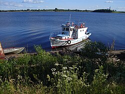
326:, and administrative center of Ust-Kubinsky District, is located in the mouth of the Kubena.
246:
47:
290:
213:
107:
282:
221:
418:
330:
334:
233:
349:
102:
397:
136:
123:
377:
344:
The source of the Kubena is located in the hills south of the settlement of
302:
298:
225:
28:
313:
345:
338:
318:
294:
217:
286:
64:
232:
237:
Map of the
Northern Dvina basin. The Kubena is shown on the map.
341:, Kharovsk, and Ustye, are located in the basin of the Kubena.
337:
in the east. Four district centers of
Vologda Oblast,
209:
204:
190:
182:
170:
162:
152:
113:
101:
87:
79:
70:
60:
55:
35:
21:
316:is situated on the left bank of the river. The
39:
8:
402:(in Russian). State Water Register of Russia
324:Ustye, Ust-Kubinsky District, Vologda Oblast
364:
196:52.2 m/s (1,840 cu ft/s)
174:11,000 km (4,200 sq mi)
18:
372:
370:
368:
7:
14:
293:and belongs to the basins of the
27:
301:. Its main tributaries are the
115: • coordinates
1:
71:Physical characteristics
435:Rivers of Arkhangelsk Oblast
382:. Great Soviet Encyclopedia.
154: • elevation
89: • location
451:
425:Tributaries of the Sukhona
192: • average
250:
200:
178:
166:368 km (229 mi)
97:
75:
40:
26:
430:Rivers of Vologda Oblast
398:
158:110 m (360 ft)
279:Ust-Kubinsky Districts
238:
236:
137:59.58889°N 39.62222°E
399:Река Кубена (Кубина)
333:in the west and the
205:Basin features
133: /
259:Arkhangelsk Oblast
255:Konoshsky District
239:
142:59.58889; 39.62222
231:
230:
442:
411:
409:
407:
384:
383:
374:
253:) is a river in
252:
193:
148:
147:
145:
144:
143:
138:
134:
131:
130:
129:
126:
90:
51:
43:
42:
31:
19:
450:
449:
445:
444:
443:
441:
440:
439:
415:
414:
405:
403:
400:
396:
393:
388:
387:
376:
375:
366:
361:
305:(left) and the
291:Lake Kubenskoye
214:Lake Kubenskoye
191:
155:
141:
139:
135:
132:
127:
124:
122:
120:
119:
116:
108:Lake Kubenskoye
93:Konosha heights
88:
45:
17:
16:River in Russia
12:
11:
5:
448:
446:
438:
437:
432:
427:
417:
416:
413:
412:
392:
391:External links
389:
386:
385:
363:
362:
360:
357:
283:Vologda Oblast
229:
228:
222:Northern Dvina
211:
207:
206:
202:
201:
198:
197:
194:
188:
187:
184:
180:
179:
176:
175:
172:
168:
167:
164:
160:
159:
156:
153:
150:
149:
117:
114:
111:
110:
105:
99:
98:
95:
94:
91:
85:
84:
81:
77:
76:
73:
72:
68:
67:
62:
58:
57:
53:
52:
37:
33:
32:
24:
23:
15:
13:
10:
9:
6:
4:
3:
2:
447:
436:
433:
431:
428:
426:
423:
422:
420:
401:
395:
394:
390:
381:
380:
373:
371:
369:
365:
358:
356:
353:
351:
347:
342:
340:
336:
332:
327:
325:
321:
320:
315:
310:
308:
304:
300:
296:
292:
288:
284:
280:
276:
272:
268:
264:
260:
256:
248:
244:
235:
227:
223:
219:
215:
212:
208:
203:
199:
195:
189:
185:
181:
177:
173:
169:
165:
161:
157:
151:
146:
118:
112:
109:
106:
104:
100:
96:
92:
86:
82:
78:
74:
69:
66:
63:
59:
54:
49:
38:
34:
30:
25:
20:
404:. Retrieved
378:
354:
343:
328:
317:
312:The town of
311:
242:
240:
350:river delta
267:Syamzhensky
263:Vozhegodsky
210:Progression
140: /
36:Native name
419:Categories
406:20 October
359:References
171:Basin size
128:39°37′20″E
125:59°35′20″N
309:(right).
303:Syamzhena
299:White Sea
271:Kharovsky
226:White Sea
183:Discharge
314:Kharovsk
297:and the
275:Sokolsky
56:Location
346:Konosha
339:Syamzha
295:Sukhona
247:Russian
218:Sukhona
61:Country
48:Russian
379:Кубена
287:Russia
277:, and
251:Кубена
243:Kubena
186:
163:Length
83:
80:Source
65:Russia
44:
41:Кубена
22:Kubena
331:Onega
103:Mouth
408:2011
335:Vaga
319:selo
261:and
241:The
322:of
307:Sit
285:in
281:of
257:of
421::
367:^
352:.
273:,
269:,
265:,
249::
224:→
220:→
216:→
410:.
245:(
50:)
46:(
Text is available under the Creative Commons Attribution-ShareAlike License. Additional terms may apply.