114:
98:
902:
83:
733:
948:
73:
58:
1185:
694:
346:
851:
121:
445:) characterized by warm summers and cool winters with light to no snowfall. The average annual temperature in Kudoyama is 13.3 °C. The average annual rainfall is 1781 mm with September as the wettest month. The temperatures are highest on average in August, at around 25.1 °C, and lowest in January, at around 1.8 °C.
403:
Kudoyama is located near the prefectural border at the northeastern end of
Wakayama Prefecture, on the south bank of the Kinokawa River, and consists of a valley formed along the Fudodani River that flows into it, and a valley formed by the Nyu River that flows into it from the east.
625:. The village of Kudyama was established with the creation of the modern municipalities system on April 1, 1889, and was raised to town status on September 1, 1910. The village of Kane was annexed by Kudoyama on March 31, 1955.
748:
113:
1222:
97:
901:
679:
Kudoyama has three public elementary schools and two public middle schools operated by the town government. The town does not have a high school.
1169:
1241:
891:
145:
1251:
646:
947:
82:
1215:
1075:
869:
642:
855:
1141:
1246:
1129:
753:
665:
and seasonal tourism. The town has long been regarded as the gateway to the temples of Mount Koya. The production of
72:
1208:
1038:
919:
438:
323:
57:
1016:
736:
185:
823:
697:
1107:
884:
376:
372:
214:
758:
641:
town council of 10 members. Kudoyama collectively with the town of Kōya, contributes one member to the
395:
of 91 persons per km. The total area of the town is 44.15 square kilometres (17.05 sq mi).
1048:
929:
715:
711:
197:
1151:
1146:
1112:
1090:
1021:
995:
975:
905:
719:
701:
453:
Per
Japanese census data, the population of Kudoyama has declined steadily over the last 70 years.
421:
416:
380:
277:
202:
1122:
1085:
1080:
1026:
990:
780:
392:
209:
1117:
970:
877:
784:
426:
1192:
1156:
1134:
1063:
1058:
1043:
1000:
985:
789:
707:
1100:
1053:
1031:
980:
965:
937:
914:
622:
618:
1068:
834:
614:
333:
48:
1235:
1095:
650:
634:
190:
662:
602:
594:
645:. In terms of national politics, the town is part of Wakayama 2nd district of the
17:
1184:
776:
693:
638:
598:
388:
273:
160:
147:
268:
345:
850:
763:
610:
606:
861:
810:
298:
667:
384:
344:
470:
873:
387:. As of 30 November 2021, the town had an estimated
946:
749:
Sacred Sites and
Pilgrimage Routes in the Kii Mountain Range
465:
593:
The area of the modern town of
Kudoyama was within ancient
288:
1190 Kudoyama, Kudoyama-cho, Ito-gun, Wakayama-ken 648-0198
1196:
637:
form of government with a directly elected mayor and a
1009:
958:
928:
329:
319:
292:
284:
267:
259:
251:
246:
238:
233:
225:
220:
208:
196:
184:
176:
34:
364:
358:
1216:
885:
8:
456:
102:Location of Kudoyama in Wakayama Prefecture
1223:
1209:
892:
878:
870:
455:
31:
802:
661:The economy of Kudoyama is centered on
609:, which had the grave of the mother of
314:
291:
283:
266:
245:
232:
219:
175:
140:
106:
94:
66:
54:
1170:List of mergers in Wakayama Prefecture
328:
318:
258:
250:
242:44.15 km (17.05 sq mi)
237:
224:
207:
195:
183:
7:
1191:This Wakayama location article is a
1181:
1179:
811:"Kudoyama Town official statistics"
617:, it was the location of exile for
1195:. You can help Knowledge (XXG) by
391:of 3,996 in 1770 households and a
25:
1183:
900:
849:
731:
692:
120:
119:
112:
96:
81:
71:
56:
835:Kudoyama population statistics
1:
671:paper is a local handicraft.
643:Wakayama Prefectural Assembly
597:and was long associated with
1242:Towns in Wakayama Prefecture
771:Notable people from Kudoyama
951:Flag of Wakayama Prefecture
408:Neighbouring municipalities
365:
1268:
1178:
1167:
944:
912:
862:Kudoyama official website
792:, Olympic baseball player
483:—
439:Humid subtropical climate
359:
339:
315:
310:
306:
141:
107:
95:
67:
55:
46:
1252:Wakayama geography stubs
38:
737:National Route 370
698:Nankai Electric Railway
952:
350:
263:91/km (230/sq mi)
950:
824:Kudoyama climate data
813:(in Japanese). Japan.
754:Kōyasan chōishi-michi
457:Historical population
348:
29:Town in Kansai, Japan
1076:Higashimuro District
858:at Wikimedia Commons
412:Wakayama Prefecture
260: • Density
62:Kudoyama town office
906:Wakayama Prefecture
458:
381:Wakayama Prefecture
157: /
1247:Kudoyama, Wakayama
1142:Nishimuro District
953:
856:Kudoyama, Wakayama
759:Niukanshōfu Shrine
393:population density
351:
334:Japanese persimmon
252: • Total
239: • Total
226: • Mayor
161:34.283°N 135.567°E
18:Kudoyama, Wakayama
1204:
1203:
1176:
1175:
923:
854:Media related to
785:Yokohama BayStars
743:Local attractions
586:
585:
343:
342:
285:City hall address
133:Location in Japan
16:(Redirected from
1259:
1225:
1218:
1211:
1187:
1180:
917:
904:
894:
887:
880:
871:
866:
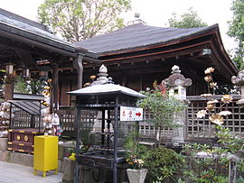
853:
837:
832:
826:
821:
815:
814:
807:
790:Masanori Sugiura
735:
734:
702:Nankai Kōya Line
696:
605:, the temple of
472:
467:
459:
370:
368:
362:
361:
302:
301:
299:Official website
172:
171:
169:
168:
167:
162:
158:
155:
154:
153:
150:
123:
122:
116:
100:
85:
75:
60:
41:
32:
21:
1267:
1266:
1262:
1261:
1260:
1258:
1257:
1256:
1232:
1231:
1230:
1229:
1177:
1172:
1163:
1039:Hidaka District
1005:
954:
942:
924:
908:
898:
864:
846:
841:
840:
833:
829:
822:
818:
809:
808:
804:
799:
773:
745:
732:
728:
690:
685:
677:
659:
633:Kudoyama has a
631:
623:Sanada Yukimura
619:Sanada Masayuki
591:
451:
437:Kudoyama has a
435:
410:
401:
356:
349:Jison-in temple
297:
296:
166:34.283; 135.567
165:
163:
159:
156:
151:
148:
146:
144:
143:
137:
136:
135:
134:
131:
130:
129:
128:
124:
103:
91:
90:
89:
88:
79:
78:
63:
51:
42:
39:
37:
30:
23:
22:
15:
12:
11:
5:
1265:
1263:
1255:
1254:
1249:
1244:
1234:
1233:
1228:
1227:
1220:
1213:
1205:
1202:
1201:
1188:
1174:
1173:
1168:
1165:
1164:
1162:
1161:
1160:
1159:
1154:
1149:
1139:
1138:
1137:
1130:Kaisō District
1127:
1126:
1125:
1120:
1115:
1105:
1104:
1103:
1098:
1093:
1088:
1083:
1073:
1072:
1071:
1066:
1061:
1056:
1051:
1046:
1036:
1035:
1034:
1029:
1024:
1017:Arida District
1013:
1011:
1007:
1006:
1004:
1003:
998:
993:
988:
983:
978:
973:
968:
962:
960:
956:
955:
945:
943:
941:
940:
934:
932:
926:
925:
913:
910:
909:
899:
897:
896:
889:
882:
874:
868:
867:
859:
845:
844:External links
842:
839:
838:
827:
816:
801:
800:
798:
795:
794:
793:
787:
772:
769:
768:
767:
761:
756:
751:
744:
741:
740:
739:
727:
724:
723:
722:
689:
686:
684:
683:Transportation
681:
676:
673:
658:
655:
630:
627:
615:Sengoku period
590:
587:
584:
583:
580:
577:
573:
572:
569:
566:
562:
561:
558:
555:
551:
550:
547:
544:
540:
539:
536:
533:
529:
528:
525:
522:
518:
517:
514:
511:
507:
506:
503:
500:
496:
495:
492:
489:
485:
484:
481:
478:
474:
473:
468:
463:
450:
447:
434:
431:
430:
429:
424:
419:
409:
406:
400:
397:
341:
340:
337:
336:
331:
327:
326:
321:
317:
316:
313:
312:
308:
307:
304:
303:
294:
290:
289:
286:
282:
281:
271:
265:
264:
261:
257:
256:
253:
249:
248:
244:
243:
240:
236:
235:
231:
230:
227:
223:
222:
218:
217:
212:
206:
205:
200:
194:
193:
188:
182:
181:
178:
174:
173:
139:
138:
132:
126:
125:
118:
117:
111:
110:
109:
108:
105:
104:
101:
93:
92:
86:
80:
76:
70:
69:
68:
65:
64:
61:
53:
52:
47:
44:
43:
35:
28:
24:
14:
13:
10:
9:
6:
4:
3:
2:
1264:
1253:
1250:
1248:
1245:
1243:
1240:
1239:
1237:
1226:
1221:
1219:
1214:
1212:
1207:
1206:
1200:
1198:
1194:
1189:
1186:
1182:
1171:
1166:
1158:
1155:
1153:
1150:
1148:
1145:
1144:
1143:
1140:
1136:
1133:
1132:
1131:
1128:
1124:
1121:
1119:
1116:
1114:
1111:
1110:
1109:
1106:
1102:
1099:
1097:
1096:Nachikatsuura
1094:
1092:
1089:
1087:
1084:
1082:
1079:
1078:
1077:
1074:
1070:
1067:
1065:
1062:
1060:
1057:
1055:
1052:
1050:
1047:
1045:
1042:
1041:
1040:
1037:
1033:
1030:
1028:
1025:
1023:
1020:
1019:
1018:
1015:
1014:
1012:
1008:
1002:
999:
997:
994:
992:
989:
987:
984:
982:
979:
977:
974:
972:
969:
967:
964:
963:
961:
957:
949:
939:
936:
935:
933:
931:
927:
921:
916:
911:
907:
903:
895:
890:
888:
883:
881:
876:
875:
872:
865:(in Japanese)
863:
860:
857:
852:
848:
847:
843:
836:
831:
828:
825:
820:
817:
812:
806:
803:
796:
791:
788:
786:
782:
778:
775:
774:
770:
765:
762:
760:
757:
755:
752:
750:
747:
746:
742:
738:
730:
729:
725:
721:
717:
713:
709:
706:
705:
704:
703:
699:
695:
687:
682:
680:
674:
672:
670:
669:
664:
656:
654:
652:
651:Diet of Japan
648:
644:
640:
636:
635:mayor-council
628:
626:
624:
620:
616:
613:. During the
612:
608:
604:
600:
596:
588:
581:
578:
575:
574:
570:
567:
564:
563:
559:
556:
553:
552:
548:
545:
542:
541:
537:
534:
531:
530:
526:
523:
520:
519:
515:
512:
509:
508:
504:
501:
498:
497:
493:
490:
487:
486:
482:
479:
476:
475:
469:
464:
461:
460:
454:
448:
446:
444:
440:
432:
428:
425:
423:
420:
418:
415:
414:
413:
407:
405:
398:
396:
394:
390:
386:
382:
378:
374:
367:
355:
347:
338:
335:
332:
325:
322:
309:
305:
300:
295:
287:
279:
275:
272:
270:
262:
254:
241:
229:Akira Okamoto
228:
216:
213:
211:
204:
201:
199:
192:
189:
187:
179:
170:
142:Coordinates:
115:
99:
84:
74:
59:
50:
45:
33:
27:
19:
1197:expanding it
1190:
1108:Ito District
830:
819:
805:
716:Shimo-Kosawa
691:
678:
666:
663:horticulture
660:
632:
603:Heian period
595:Kii Province
592:
452:
449:Demographics
442:
436:
411:
402:
377:Ito District
366:Kudoyama-chō
353:
352:
26:
777:Takao Obana
720:Kami-Kosawa
647:lower house
375:located in
164: /
1236:Categories
1049:Hidakagawa
797:References
639:unicameral
629:Government
599:Mount Koya
389:population
324:Tree Peony
247:Population
221:Government
198:Prefecture
1152:Shirahama
1147:Kamitonda
1113:Katsuragi
1091:Kushimoto
1022:Aridagawa
1010:Districts
976:Hashimoto
930:Core city
712:Kōyashita
675:Education
601:. In the
422:Katsuragi
417:Hashimoto
399:Geography
274:UTC+09:00
269:Time zone
1123:Kudoyama
1086:Kozagawa
1081:Kitayama
1027:Hirogawa
991:Kinokawa
938:Wakayama
915:Wakayama
764:Jison-in
708:Kudoyama
607:Jison-in
441:(Köppen
354:Kudoyama
210:District
203:Wakayama
152:135°34′E
127:Kudoyama
36:Kudoyama
920:capital
783:of the
781:manager
726:Highway
688:Railway
657:Economy
649:of the
589:History
433:Climate
311:Symbols
293:Website
177:Country
149:34°17′N
1157:Susami
1135:Kimino
1064:Minabe
1059:Mihama
1044:Hidaka
1001:Tanabe
996:Shingū
986:Kainan
959:Cities
766:temple
582:−18.3%
571:−14.2%
516:+24.9%
320:Flower
191:Kansai
186:Region
87:Emblem
1101:Taiji
1054:Inami
1032:Yuasa
981:Iwade
966:Arida
668:washi
611:Kūkai
579:4,963
576:2010
568:6,073
565:2000
560:−8.0%
557:7,076
554:1990
549:−4.9%
546:7,693
543:1980
538:−5.3%
535:8,091
532:1970
527:−8.1%
524:8,544
521:1960
513:9,299
510:1950
505:−3.3%
502:7,446
499:1940
494:+1.8%
491:7,700
488:1930
480:7,567
477:1920
385:Japan
371:is a
255:3,996
180:Japan
1193:stub
1118:Kōya
1069:Yura
971:Gobō
621:and
466:Pop.
462:Year
427:Kōya
373:town
360:九度山町
330:Tree
234:Area
77:Flag
49:Town
40:九度山町
653:.
443:Cfa
278:JST
215:Ito
1238::
779:,
718:-
714:-
710:-
700:–
471:±%
383:,
379:,
363:,
1224:e
1217:t
1210:v
1199:.
922:)
918:(
893:e
886:t
879:v
369:)
357:(
280:)
276:(
20:)
Text is available under the Creative Commons Attribution-ShareAlike License. Additional terms may apply.