173:
768:
180:
141:
134:
426:
825:
29:
378:
in the world. It is also notable for its rise above local terrain: for example, it rises almost 4,000 metres (13,000 ft) above its southern base camp on the
Kunyang Glacier, and it rises 5,500 metres (3.4 mi) above the Hunza valley in about 33 kilometres (108,000 ft). Though it shares
758:
Kunyang Chhish North. A Japanese expedition from
Hokkaido University in 1979 was led by Kohei Echizenya climbed the north ridge of Kunyang Chhish (23,321 feet) to make the first ascent. Base Camp was placed on the Kunyang Glacier at 14,300 feet on June 17. They followed the same route as the
442:
The first attempt to climb
Khunyang Chhish was made in 1962 but the climb was aborted after an avalanche on 18 July killed two climbers, Major James Mills and Captain M. R. F. Jones, at about 20,000 feet (6,100 m) on the south ridge. Their bodies were never recovered.
473:
climbers, Mark Lowe and Keith Milne, who climbed the
Northwest Spur to the North Ridge and completed this route on July 11, 1988. The route had first been attempted in 1980, and had been attempted again in 1981, 1982 and 1987.
465:
in 1971. They climbed a more direct, but nonetheless lengthy, route up the South Ridge of the peak from the Pumari Chhish
Glacier. However, one of their members, Jan Franczuk, was killed in a crevasse accident.
481:
lists three recent attempts on this peak, in 2000 and 2003. With just six known ascents and at least five confirmed deaths during attempts, the mountain has one of the steepest fatality rates in the
Karakoram.
759:
expedition to Pumari Chhish as far as the north col. Three camps, the highest Camp IV at 22,000 feet, were established on the north ridge. All eight climbers got to the summit on July 11.
809:
454:
members. They also chose the south ridge of
Kunyang Chhish, but another climber Takeo Nakamura died after the collapse of a narrow ridge at 7,200 m (23,600 ft).
513:
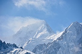
748:
172:
895:
866:
885:
89:
900:
802:
625:
133:
644:
890:
795:
682:
700:
746:
Northern
Pakistan - highly detailed placemarks of towns, villages, peaks, glaciers, rivers and minor tributaries in Google Earth
859:
498:
279:
82:
717:
745:
547:
414:
Kunyang Chhish West, 7,350 metres (24,110 ft), 1.5 km W, 170-metre (560 ft) prominence. Also known as
852:
767:
508:
375:
339:
52:
383:
to the north, it is a steep, pointed, and complex peak compared to
Distaghil, which has a more rounded profile.
402:
60:
421:
Kunyang Chhish North, 7,108 metres (23,320 ft), 6 km NNE, 517-metre (1,696 ft) prominence.
243:
425:
239:
75:
486:
451:
408:
563:
70:
678:
650:
640:
836:
779:
775:
503:
358:. It rises northeast of the confluence of the Hispar Glacier and the Kunyang Glacier, while
235:
153:
350:
Kunyang Chhish is located along the northern flank of the Hispar
Glacier, one of the major
752:
354:
of the Karakoram. It is the source of the Yazghil glacier that terminates in the heart of
710:
470:
462:
363:
319:
247:
213:
206:
879:
594:
430:
387:
380:
359:
824:
732:
254:
229:
411:
7,400 metres (24,300 ft), 2 km ESE, 240-metre (790 ft) prominence.
535:
489:
was first ascended in July 2013 by an Austrian/Swiss team over the South Wall.
654:
104:
91:
725:
323:
217:
690:
by Jerzy Wala, 1990. Published by the Swiss Foundation for Alpine Research.
832:
355:
327:
315:
157:
338:. Its height, also sometimes given as 7,823 metres (25,666 ft), is
28:
401:
Kunyang Chhish South, 7,620 metres (25,000 ft), 700 m SSW, with a
351:
458:
391:
44:
705:
478:
447:
424:
390:
summits 4 kilometres (2.5 mi) to the ENE, the Kunyang Chhish
626:"Ups and Downs on Kunyang Kish - The Second Ascent, 11 July 1988"
433:(left background) as seen from Yazghil Sar's western slopes.
733:
A list of world peaks ranked by local relief and steepness
675:
High Asia: An Illustrated History of the 7000 Metre Peaks
840:
783:
469:
The second, and only other recorded ascent, was by two
485:
After four failed expeditions, starting in 2003, the
366:) dominates the Kunyang Glacier on its northern end.
296:
278:
269:
253:
228:
223:
205:
120:
81:
69:
59:
43:
38:
21:
398:Kunyang Chhish Main, 7,852 metres (25,761 ft)
595:"Obituary - Major E. J. E. Mills, (1926-1962)"
514:List of Ultras of the Karakoram and Hindu Kush
860:
803:
284:
8:
867:
853:
810:
796:
330:. An alternate variations of the name are
293:
18:
688:Orographical Sketch Map of the Karakoram
429:Khunyang Chhish (centre background) and
525:
457:The first ascent was accomplished by a
405:of only about 100 metres (330 ft)
266:
179:
140:
557:
555:
7:
821:
819:
764:
762:
693:Andy Fanshawe and Stephen Venables,
531:
529:
896:Seven-thousanders of the Karakoram
839:. You can help Knowledge (XXG) by
782:. You can help Knowledge (XXG) by
548:Khunyang Chhish on bbs.keyhole.com
446:The next attempt was in 1965 by a
14:
713:(Corrected versions of SRTM data)
192:Kunyang Chhish (Gilgit Baltistan)
33:Kunyang Chhish from the northeast
886:Gilgit-Baltistan geography stubs
823:
766:
178:
171:
139:
132:
27:
450:party mainly consisting of the
379:a high key col with its parent
735:which includes Khunyang Chhish
536:"Kunyang Chhish" on Peakbagger
509:Highest mountains of the World
285:
1:
901:Mountains of Gilgit-Baltistan
697:, Hodder and Stoughton, 1995.
499:List of mountains in Pakistan
49:7,852 m (25,761 ft)
195:Show map of Gilgit Baltistan
65:1,765 m (5,791 ft)
538:Retrieved 25 September 2011
917:
818:
761:
711:DEM files for the Himalaya
593:Braham, Trevor H. (1963).
504:Gilgit-Baltistan, Pakistan
564:"Khinyang Chhish climbed"
362:(the highest peak of the
305:
292:
274:
125:
26:
891:Pakistan geography stubs
624:Wingfield, Andy (1989).
701:American Alpine Journal
280:Simplified Chinese
835:location article is a
778:location article is a
434:
374:Kunyang Chhish is the
314:is the second-highest
261:glacier/rock/ice climb
695:Himalaya Alpine-Style
562:Kus, Andrzej (1971).
428:
386:Not counting the two
376:21st highest mountain
105:36.20528°N 75.20778°E
322:, a subrange in the
162:Show map of Pakistan
16:Mountain in Pakistan
452:University of Tokyo
409:Kunyang Chhish East
234:August 26, 1971 by
101: /
751:2012-02-04 at the
435:
110:36.20528; 75.20778
39:Highest point
848:
847:
791:
790:
718:"Khunyang Chhish"
599:Himalayan Journal
568:Himalayan Journal
309:
308:
301:
300:
265:
264:
244:Ryszard Szafirski
55:
908:
869:
862:
855:
827:
820:
812:
805:
798:
776:Gilgit-Baltistan
770:
763:
729:
724:. Archived from
666:
665:
663:
661:
630:
621:
615:
614:
612:
610:
590:
584:
583:
581:
579:
559:
550:
545:
539:
533:
438:Climbing history
394:has five peaks:
370:Notable features
294:
288:
287:
267:
257:
236:Andrzej Heinrich
209:
196:
182:
181:
175:
163:
154:Gilgit-Baltistan
143:
142:
136:
116:
115:
113:
112:
111:
106:
102:
99:
98:
97:
94:
51:
31:
19:
916:
915:
911:
910:
909:
907:
906:
905:
876:
875:
874:
873:
817:
816:
753:Wayback Machine
742:
716:
706:Himalayan Index
670:
669:
659:
657:
647:
628:
623:
622:
618:
608:
606:
592:
591:
587:
577:
575:
561:
560:
553:
546:
542:
534:
527:
522:
495:
479:Himalayan Index
440:
372:
356:Shimshal Valley
348:
336:Khinyang Chhish
255:
240:Jan Stryczynski
207:
201:
200:
199:
198:
197:
194:
193:
190:
189:
188:
187:
183:
166:
165:
164:
161:
160:
151:
150:
149:
148:
144:
109:
107:
103:
100:
95:
92:
90:
88:
87:
50:
34:
17:
12:
11:
5:
914:
912:
904:
903:
898:
893:
888:
878:
877:
872:
871:
864:
857:
849:
846:
845:
828:
815:
814:
807:
800:
792:
789:
788:
771:
756:
755:
741:
740:External links
738:
737:
736:
730:
728:on 2016-03-04.
714:
708:
703:
698:
691:
685:
668:
667:
646:978-0091737702
645:
639:(338): 76–81.
633:Alpine Journal
616:
585:
551:
540:
524:
523:
521:
518:
517:
516:
511:
506:
501:
494:
491:
463:Andrzej Zawada
439:
436:
423:
422:
419:
412:
406:
399:
371:
368:
364:Hispar Muztagh
347:
344:
342:in the world.
320:Hispar Muztagh
312:Kunyang Chhish
307:
306:
303:
302:
299:
298:
297:Transcriptions
290:
289:
282:
276:
275:
272:
271:
270:Kunyang Chhish
263:
262:
259:
251:
250:
248:Andrzej Zawada
232:
226:
225:
221:
220:
214:Hispar Muztagh
211:
203:
202:
191:
186:Kunyang Chhish
185:
184:
177:
176:
170:
169:
168:
167:
152:
147:Kunyang Chhish
146:
145:
138:
137:
131:
130:
129:
128:
127:
126:
123:
122:
118:
117:
85:
79:
78:
73:
67:
66:
63:
57:
56:
47:
41:
40:
36:
35:
32:
24:
23:
22:Kunyang Chhish
15:
13:
10:
9:
6:
4:
3:
2:
913:
902:
899:
897:
894:
892:
889:
887:
884:
883:
881:
870:
865:
863:
858:
856:
851:
850:
844:
842:
838:
834:
829:
826:
822:
813:
808:
806:
801:
799:
794:
793:
787:
785:
781:
777:
772:
769:
765:
760:
754:
750:
747:
744:
743:
739:
734:
731:
727:
723:
719:
715:
712:
709:
707:
704:
702:
699:
696:
692:
689:
686:
684:
683:0-89886-238-8
680:
676:
672:
671:
656:
652:
648:
642:
638:
634:
627:
620:
617:
604:
600:
596:
589:
586:
573:
569:
565:
558:
556:
552:
549:
544:
541:
537:
532:
530:
526:
519:
515:
512:
510:
507:
505:
502:
500:
497:
496:
492:
490:
488:
483:
480:
475:
472:
467:
464:
460:
455:
453:
449:
444:
437:
432:
431:Pumari Chhish
427:
420:
417:
413:
410:
407:
404:
400:
397:
396:
395:
393:
389:
388:Pumari Chhish
384:
382:
381:Distaghil Sar
377:
369:
367:
365:
361:
360:Distaghil Sar
357:
353:
345:
343:
341:
337:
333:
329:
326:mountains in
325:
321:
317:
313:
304:
295:
291:
283:
281:
277:
273:
268:
260:
258:
256:Easiest route
252:
249:
245:
241:
237:
233:
231:
227:
222:
219:
215:
212:
210:
204:
174:
159:
155:
135:
124:
119:
114:
86:
84:
80:
77:
74:
72:
68:
64:
62:
58:
54:
48:
46:
42:
37:
30:
25:
20:
841:expanding it
830:
784:expanding it
773:
757:
726:the original
722:Peakware.com
721:
694:
687:
674:
673:Jill Neate,
658:. Retrieved
636:
632:
619:
607:. Retrieved
602:
598:
588:
576:. Retrieved
571:
567:
543:
484:
476:
468:
461:team led by
456:
445:
441:
416:Pyramid Peak
415:
385:
373:
349:
335:
332:Kunyang Kish
331:
311:
310:
230:First ascent
208:Parent range
487:East summit
340:ranked 21st
108: /
83:Coordinates
53:Ranked 21st
880:Categories
520:References
403:prominence
96:75°12′28″E
93:36°12′19″N
61:Prominence
655:0065-6569
605:: 139–140
574:: 283–289
324:Karakoram
218:Karakoram
121:Geography
45:Elevation
833:Pakistan
749:Archived
493:See also
448:Japanese
352:glaciers
346:Location
328:Pakistan
316:mountain
224:Climbing
158:Pakistan
156:region,
660:11 June
609:11 June
471:British
318:in the
71:Listing
681:
653:
643:
578:20 May
459:Polish
392:massif
831:This
774:This
629:(PDF)
286:昆揚基什峰
76:Ultra
837:stub
780:stub
679:ISBN
662:2024
651:ISSN
641:ISBN
611:2024
580:2024
477:The
334:and
677:,
637:#94
603:#24
572:#31
882::
720:.
649:.
635:.
631:.
601:.
597:.
570:.
566:.
554:^
528:^
246:,
242:,
238:,
216:,
868:e
861:t
854:v
843:.
811:e
804:t
797:v
786:.
664:.
613:.
582:.
418:.
Text is available under the Creative Commons Attribution-ShareAlike License. Additional terms may apply.