460:) . The average annual temperature in Kuroshio is 16.6 °C (61.9 °F). The average annual rainfall is 2,812.9 mm (110.74 in) with June as the wettest month. The temperatures are highest on average in August, at around 26.9 °C (80.4 °F), and lowest in January, at around 6.4 °C (43.5 °F). The highest temperature ever recorded in Kuroshio was 38.6 °C (101.5 °F) on 25 July 2013; the coldest temperature ever recorded was −7.3 °C (18.9 °F) on 27 February 1981. Winter (late November through to mid March) can be very dry and chilling with many homes and schools using kerosene heaters to keep warm. Temperatures average 13 °C (55 °F) in the daytime and 2 °C (36 °F) at night. It occasionally snows in the winter though often does not last the day due to the town's close proximity to the coast. The summer months (July - September) are hot and humid. The temperature in summer can reach an average of 32 °C (90 °F) in the day and about 24 °C (75 °F) at night. Rainy season is in June and generally lasts three weeks. Kochi experiences a typhoon season which lasts from July until September. Spring and autumn are mild months with some wet and windy days.
103:
90:
1428:
68:
1690:
58:
352:
43:
1446:, National Place of Scenic Beauty. Baby turtles can be seen entering the water at sunrise from August through September on Irino Beach. Local volunteers help to protect the nests and the young turtles from birds and the trampling feet of beach goers. The volunteers are happy to include early morning spectators in the task of preparing and protecting the newly hatched turtles for their first experience of the open sea. During
1418:
1644:
1589:
110:
1307:
mushrooms and greenhouse horticulture, flowers, and paddy rice. In recent years, sun-dried salt has become a representative specialty product. Seasonal tourism, particularly in the summer for camping and surfing is playing an increasing role in the local economy.
1316:
Kuroshio has eight public elementary schools and two public middle schools operated by the town government, and one public high school operated by the Kōchi
Prefectural Board of Education. The town participates in the
1336:
School. The
Kuroshio students are accompanied by a Kuroshio Board of Education representative, two teachers and one of the JET participants (usually a New Zealander). The students participate in school activities and
1450:
Kuroshio's
Seaside Gallery hosts the annual T-shirt Art Exhibition on Irino beach. Many entries are made from both within Japan and internationally and draw a great number of tourists to the area.
1341:
classes while at
Fairfield Intermediate. Occasionally Fairfield Intermediate have sent a group of students and teachers to visit Kuroshio. The relationship between the two schools began in 1999.
1259:
with the creation of the modern municipalities system on
October 1, 1889. Saga was raised to town status on November 3, 1940. On March 20, 2006, Saga merged with the neighboring town of
1279:
town council of 14 members. Kuroshio contributes one member to the Kōchi
Prefectural Assembly. In terms of national politics, the town is part of Kōchi 2nd district of the
401:
of 56 persons per km. The total area of the town is 188.59 square kilometres (72.82 sq mi). The residents speak a distinct dialect of
Japanese known as Hata-ben.
1513:
102:
1543:
1633:
1957:
134:
1928:
1947:
1324:
Every year in late August, during the summer vacation, twelve third year students chosen from
Kuroshio's two junior high schools travel to
1358:
1280:
1626:
1049:
Per
Japanese census data, the population of Kuroshio in 2020 is 10,262 people. Kuroshio has been conducting censuses since 1960.
454:
269:
89:
67:
1689:
1619:
1549:
1519:
1035:
1952:
1321:, employing two representatives who regularly visit the junior high schools and elementary schools to teach English.
1863:
1846:
1593:
1388:
1888:
1729:
1661:
450:
438:
433:
274:
42:
57:
174:
1765:
1905:
1824:
1431:
1256:
382:
203:
1782:
1404:
1392:
1380:
1333:
378:
1354:
1325:
1915:
1749:
1671:
1443:
1376:
186:
1807:
1647:
1471:
1447:
1421:
386:
253:
191:
1839:
1458:
1400:
1296:
398:
315:
198:
1910:
1856:
1851:
1792:
1714:
1260:
418:
1724:
1372:
1248:
988:
329:
1883:
1868:
1834:
1817:
1797:
1787:
1739:
1734:
1719:
1396:
1384:
339:
1492:
351:
1893:
1812:
1679:
1656:
1244:
1878:
1802:
1744:
1709:
1252:
311:
1457:
is located on Japan
National Route 56, ten minutes east of Saga. Many pilgrims on the
1941:
1770:
1704:
1368:
1364:
1318:
1300:
1284:
1272:
1240:
1228:
867:
414:
1572:
1236:
1775:
1276:
1232:
394:
249:
149:
136:
1643:
244:
1611:
1588:
1227:
As with all of Kōchi Prefecture, the area of Kuroshio was part of ancient
417:
to the southeast. Kuroshio is located two hours (by car or train) west of
1898:
1873:
1329:
1304:
410:
179:
409:
Kuroshio is located in southwestern Kōchi Prefecture on the island of
467:
Climate data for Kuroshio (1991−2020 normals, extremes 1977−present)
325:
1601:
1454:
390:
350:
286:
1066:
1615:
1338:
1061:
393:. As of 31 July 2022, the town had an estimated
1275:
form of government with a directly elected mayor and a
264:
5893 Irino, Kuroshio-chō, Hata-gun, Kōchi-ken 789-1992
1758:
1697:
1670:
335:
321:
307:
280:
268:
260:
243:
235:
227:
222:
214:
209:
197:
185:
173:
165:
21:
1332:with families of students who attend Hamilton's
370:
364:
1627:
8:
1052:
1634:
1620:
1612:
1538:
1536:
1051:
463:
18:
1508:
1506:
1504:
1502:
1299:, notably pole-and-line fishing for Tosa
1568:
1566:
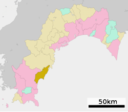
82:Location of Kuroshio in Kōchi Prefecture
1484:
1235:, the area was part of the holdings of
302:
279:
267:
259:
242:
221:
208:
164:
129:
95:
79:
51:
39:
218:188.59 km (72.82 sq mi)
413:. It has a long coastline facing the
334:
320:
306:
234:
226:
213:
196:
184:
172:
86:
7:
397:of 10,504 in 5443 households, and a
1929:List of mergers in Kōchi Prefecture
1493:"Kuroshio town official statistics"
1295:The local economy is dominated by
14:
1958:Populated coastal places in Japan
1688:
1642:
1587:
1426:
1416:
1303:, and by agriculture, including
109:
108:
101:
88:
66:
56:
41:
1573:Kuroshio population statistics
1328:. There they participate in a
1263:to form the town of Kuroshio.
1216:Kuroshio population statistics
1:
1255:(佐賀村) was established within
455:Köppen climate classification
1036:Japan Meteorological Agency
940:Average precipitation days
726:Mean daily minimum °C (°F)
586:Mean daily maximum °C (°F)
425:Neighbouring municipalities
371:
1974:
1466:Noted people from Kuroshio
1033:
466:
1948:Towns in Kōchi Prefecture
1926:
1686:
1654:
1602:Kuroshio official website
1215:
1079:—
986:
939:
865:
795:
725:
655:
585:
515:
510:
507:
504:
501:
498:
495:
492:
489:
486:
483:
480:
477:
474:
471:
451:humid subtropical climate
365:
345:
303:
298:
294:
130:
96:
87:
80:
52:
40:
33:
1544:
1514:
25:
1432:National Route 56
1334:Fairfield Intermediate
356:
239:56/km (140/sq mi)
16:Town in Shikoku, Japan
1545:観測史上1~10位の値(年間を通じての値)
1495:(in Japanese). Japan.
1355:Tosa Kuroshio Railway
1326:Hamilton, New Zealand
1053:Historical population
354:
1596:at Wikimedia Commons
1257:Hata District, Kōchi
516:Record high °C (°F)
236: • Density
47:Kuroshio Town Office
1472:Akatsuki Kambayashi
1461:stop at this onsen.
1448:Golden Week (Japan)
1243:from their seat at
1054:
796:Record low °C (°F)
656:Daily mean °C (°F)
146: /
1515:気象庁 / 平年値(年・月ごとの値)
1459:Shikoku Pilgrimage
1389:Tosa-Kamikawaguchi
1297:commercial fishing
399:population density
357:
316:Warbling white-eye
228: • Total
215: • Total
150:33.017°N 133.017°E
1935:
1934:
1665:
1592:Media related to
1438:Local attractions
1251:, the village of
1249:Meiji restoration
1220:
1219:
1041:
1040:
429:Kōchi Prefecture
349:
348:
330:Camellia japonica
261:City hall address
122:Location in Japan
1965:
1864:Takaoka District
1847:Nagaoka District
1692:
1659:
1648:Kōchi Prefecture
1646:
1636:
1629:
1622:
1613:
1608:
1605:
1604:
1591:
1575:
1570:
1561:
1560:
1558:
1556:
1540:
1531:
1530:
1528:
1526:
1510:
1497:
1496:
1489:
1430:
1429:
1422:Kōchi Expressway
1420:
1419:
1247:. Following the
1068:
1063:
1055:
943:
464:
387:Kōchi Prefecture
376:
374:
368:
367:
340:Pinus thunbergii
290:
289:
287:Official website
161:
160:
158:
157:
156:
151:
147:
144:
143:
142:
139:
112:
111:
105:
92:
70:
60:
45:
28:
19:
1973:
1972:
1968:
1967:
1966:
1964:
1963:
1962:
1953:Kuroshio, Kōchi
1938:
1937:
1936:
1931:
1922:
1754:
1693:
1684:
1666:
1650:
1640:
1606:
1600:
1599:
1594:Kuroshio, Kōchi
1584:
1579:
1578:
1571:
1564:
1554:
1552:
1546:
1542:
1541:
1534:
1524:
1522:
1516:
1512:
1511:
1500:
1491:
1490:
1486:
1481:
1468:
1444:Irino Matsubara
1440:
1427:
1417:
1413:
1352:
1347:
1314:
1293:
1271:Kuroshio has a
1269:
1225:
1047:
1042:
941:
934:
929:
924:
919:
914:
909:
904:
899:
894:
889:
884:
879:
874:
860:
855:
850:
845:
840:
835:
830:
825:
820:
815:
810:
805:
800:
790:
785:
780:
775:
770:
765:
760:
755:
750:
745:
740:
735:
730:
720:
715:
710:
705:
700:
695:
690:
685:
680:
675:
670:
665:
660:
650:
645:
640:
635:
630:
625:
620:
615:
610:
605:
600:
595:
590:
580:
575:
570:
565:
560:
555:
550:
545:
540:
535:
530:
525:
520:
449:Kuroshio has a
447:
427:
407:
362:
355:Irino Matsubara
285:
284:
155:33.017; 133.017
154:
152:
148:
145:
140:
137:
135:
133:
132:
126:
125:
124:
123:
120:
119:
118:
117:
113:
83:
76:
75:
74:
73:
64:
63:
48:
36:
29:
26:
24:
17:
12:
11:
5:
1971:
1969:
1961:
1960:
1955:
1950:
1940:
1939:
1933:
1932:
1927:
1924:
1923:
1921:
1920:
1919:
1918:
1913:
1903:
1902:
1901:
1896:
1891:
1886:
1881:
1876:
1871:
1861:
1860:
1859:
1854:
1844:
1843:
1842:
1837:
1832:
1822:
1821:
1820:
1815:
1810:
1805:
1800:
1795:
1790:
1780:
1779:
1778:
1773:
1766:Agawa District
1762:
1760:
1756:
1755:
1753:
1752:
1747:
1742:
1737:
1732:
1727:
1722:
1717:
1712:
1707:
1701:
1699:
1695:
1694:
1687:
1685:
1683:
1682:
1676:
1674:
1668:
1667:
1655:
1652:
1651:
1641:
1639:
1638:
1631:
1624:
1616:
1610:
1609:
1597:
1583:
1582:External links
1580:
1577:
1576:
1562:
1532:
1498:
1483:
1482:
1480:
1477:
1476:
1475:
1467:
1464:
1463:
1462:
1453:Kobushinosata
1451:
1439:
1436:
1435:
1434:
1424:
1412:
1409:
1408:
1407:
1381:Tosa-Shirahama
1351:
1348:
1346:
1345:Transportation
1343:
1313:
1310:
1292:
1289:
1268:
1265:
1224:
1221:
1218:
1217:
1213:
1212:
1209:
1206:
1202:
1201:
1198:
1195:
1191:
1190:
1187:
1184:
1180:
1179:
1176:
1173:
1169:
1168:
1165:
1162:
1158:
1157:
1154:
1151:
1147:
1146:
1143:
1140:
1136:
1135:
1132:
1129:
1125:
1124:
1121:
1118:
1114:
1113:
1110:
1107:
1103:
1102:
1099:
1096:
1092:
1091:
1088:
1085:
1081:
1080:
1077:
1074:
1070:
1069:
1064:
1059:
1046:
1043:
1039:
1038:
1031:
1030:
1027:
1024:
1021:
1018:
1015:
1012:
1009:
1006:
1003:
1000:
997:
994:
991:
989:sunshine hours
984:
983:
980:
977:
974:
971:
968:
965:
962:
959:
956:
953:
950:
947:
944:
937:
936:
931:
926:
921:
916:
911:
906:
901:
896:
891:
886:
881:
876:
871:
863:
862:
857:
852:
847:
842:
837:
832:
827:
822:
817:
812:
807:
802:
797:
793:
792:
787:
782:
777:
772:
767:
762:
757:
752:
747:
742:
737:
732:
727:
723:
722:
717:
712:
707:
702:
697:
692:
687:
682:
677:
672:
667:
662:
657:
653:
652:
647:
642:
637:
632:
627:
622:
617:
612:
607:
602:
597:
592:
587:
583:
582:
577:
572:
567:
562:
557:
552:
547:
542:
537:
532:
527:
522:
517:
513:
512:
509:
506:
503:
500:
497:
494:
491:
488:
485:
482:
479:
476:
473:
469:
468:
462:
446:
443:
442:
441:
436:
426:
423:
406:
403:
347:
346:
343:
342:
337:
333:
332:
323:
319:
318:
312:Kentish plover
309:
305:
304:
301:
300:
296:
295:
292:
291:
282:
278:
277:
272:
266:
265:
262:
258:
257:
247:
241:
240:
237:
233:
232:
229:
225:
224:
220:
219:
216:
212:
211:
207:
206:
201:
195:
194:
189:
183:
182:
177:
171:
170:
167:
163:
162:
128:
127:
121:
115:
114:
107:
106:
100:
99:
98:
97:
94:
93:
85:
84:
81:
78:
77:
71:
65:
61:
55:
54:
53:
50:
49:
46:
38:
37:
34:
31:
30:
22:
15:
13:
10:
9:
6:
4:
3:
2:
1970:
1959:
1956:
1954:
1951:
1949:
1946:
1945:
1943:
1930:
1925:
1917:
1914:
1912:
1909:
1908:
1907:
1906:Tosa District
1904:
1900:
1897:
1895:
1892:
1890:
1887:
1885:
1882:
1880:
1877:
1875:
1872:
1870:
1867:
1866:
1865:
1862:
1858:
1855:
1853:
1850:
1849:
1848:
1845:
1841:
1838:
1836:
1833:
1831:
1828:
1827:
1826:
1825:Hata District
1823:
1819:
1816:
1814:
1811:
1809:
1806:
1804:
1801:
1799:
1796:
1794:
1791:
1789:
1786:
1785:
1784:
1781:
1777:
1774:
1772:
1769:
1768:
1767:
1764:
1763:
1761:
1757:
1751:
1748:
1746:
1743:
1741:
1738:
1736:
1733:
1731:
1728:
1726:
1723:
1721:
1718:
1716:
1713:
1711:
1708:
1706:
1703:
1702:
1700:
1696:
1691:
1681:
1678:
1677:
1675:
1673:
1669:
1663:
1658:
1653:
1649:
1645:
1637:
1632:
1630:
1625:
1623:
1618:
1617:
1614:
1607:(in Japanese)
1603:
1598:
1595:
1590:
1586:
1585:
1581:
1574:
1569:
1567:
1563:
1551:
1547:
1539:
1537:
1533:
1521:
1517:
1509:
1507:
1505:
1503:
1499:
1494:
1488:
1485:
1478:
1473:
1470:
1469:
1465:
1460:
1456:
1452:
1449:
1445:
1442:
1441:
1437:
1433:
1425:
1423:
1415:
1414:
1410:
1406:
1402:
1398:
1394:
1390:
1386:
1382:
1378:
1374:
1370:
1366:
1363:
1362:
1361:
1360:
1359:Nakamura Line
1356:
1349:
1344:
1342:
1340:
1335:
1331:
1327:
1322:
1320:
1319:JET Programme
1311:
1309:
1306:
1302:
1301:skipjack tuna
1298:
1290:
1288:
1286:
1285:Diet of Japan
1282:
1278:
1274:
1273:mayor-council
1266:
1264:
1262:
1258:
1254:
1250:
1246:
1242:
1241:Yamauchi clan
1239:ruled by the
1238:
1234:
1231:. During the
1230:
1229:Tosa Province
1222:
1214:
1210:
1207:
1204:
1203:
1199:
1196:
1193:
1192:
1188:
1185:
1182:
1181:
1177:
1174:
1171:
1170:
1166:
1163:
1160:
1159:
1155:
1152:
1149:
1148:
1144:
1141:
1138:
1137:
1133:
1130:
1127:
1126:
1122:
1119:
1116:
1115:
1111:
1108:
1105:
1104:
1100:
1097:
1094:
1093:
1089:
1086:
1083:
1082:
1078:
1075:
1072:
1071:
1065:
1060:
1057:
1056:
1050:
1044:
1037:
1032:
1028:
1025:
1022:
1019:
1016:
1013:
1010:
1007:
1004:
1001:
998:
995:
992:
990:
987:Mean monthly
985:
981:
978:
975:
972:
969:
966:
963:
960:
957:
954:
951:
948:
945:
938:
932:
927:
922:
917:
912:
907:
902:
897:
892:
887:
882:
877:
872:
869:
868:precipitation
864:
858:
853:
848:
843:
838:
833:
828:
823:
818:
813:
808:
803:
798:
794:
788:
783:
778:
773:
768:
763:
758:
753:
748:
743:
738:
733:
728:
724:
718:
713:
708:
703:
698:
693:
688:
683:
678:
673:
668:
663:
658:
654:
648:
643:
638:
633:
628:
623:
618:
613:
608:
603:
598:
593:
588:
584:
578:
573:
568:
563:
558:
553:
548:
543:
538:
533:
528:
523:
518:
514:
470:
465:
461:
459:
456:
452:
444:
440:
439:Shimanto Town
437:
435:
434:Shimanto City
432:
431:
430:
424:
422:
420:
416:
415:Pacific Ocean
412:
404:
402:
400:
396:
392:
388:
384:
383:Hata District
380:
373:
361:
353:
344:
341:
338:
331:
327:
324:
317:
313:
310:
297:
293:
288:
283:
276:
273:
271:
263:
255:
251:
248:
246:
238:
230:
217:
205:
202:
200:
193:
190:
188:
181:
178:
176:
168:
159:
131:Coordinates:
104:
91:
69:
59:
44:
32:
20:
1829:
1783:Aki District
1553:. Retrieved
1523:. Retrieved
1487:
1353:
1323:
1315:
1294:
1270:
1245:Kōchi Castle
1226:
1048:
1045:Demographics
870:mm (inches)
457:
448:
428:
408:
372:Kuroshio-chō
359:
358:
1750:Tosashimizu
1405:Nishi-Ōgata
1393:Uminoōmukae
1281:lower house
1237:Tosa Domain
381:located in
153: /
1942:Categories
1776:Niyodogawa
1479:References
1401:Tosa-Irino
1277:unicameral
1267:Government
1233:Edo period
942:(≥ 1.0 mm)
419:Kōchi City
395:population
223:Population
187:Prefecture
1759:Districts
1672:Core city
1555:April 18,
1525:April 18,
1377:Saga-Kōen
1373:Tosa-Saga
1312:Education
935:(110.74)
405:Geography
250:UTC+09:00
245:Time zone
1899:Yusuhara
1889:Shimanto
1874:Nakatosa
1852:Motoyama
1830:Kuroshio
1793:Kitagawa
1730:Shimanto
1474:, author
1411:Highways
1397:Ukibuchi
1385:Ariigawa
1330:homestay
1305:shiitake
1034:Source:
1029:2,191.9
920:(10.08)
915:(16.09)
910:(10.82)
905:(11.11)
900:(16.71)
895:(11.11)
866:Average
581:(101.5)
556:(100.6)
551:(101.5)
360:Kuroshio
199:District
116:Kuroshio
23:Kuroshio
1725:Nankoku
1662:capital
1350:Railway
1291:Economy
1283:of the
1223:History
933:2,812.9
930:(3.69)
925:(6.04)
890:(9.25)
885:(8.04)
880:(4.67)
875:(3.12)
861:(18.9)
856:(23.0)
851:(30.9)
846:(39.0)
841:(48.6)
836:(63.1)
831:(59.9)
826:(52.0)
821:(43.0)
816:(31.8)
811:(23.2)
806:(18.9)
801:(21.0)
791:(54.5)
786:(39.0)
781:(48.6)
776:(59.0)
771:(69.3)
766:(74.7)
761:(73.4)
756:(66.2)
751:(58.6)
746:(50.5)
741:(42.3)
736:(36.7)
731:(35.2)
721:(61.8)
716:(47.1)
711:(56.5)
706:(66.2)
701:(75.2)
696:(80.4)
691:(79.0)
686:(72.0)
681:(66.4)
676:(59.2)
671:(51.3)
666:(45.3)
661:(43.5)
651:(70.4)
646:(57.0)
641:(66.4)
636:(75.4)
631:(82.8)
626:(87.3)
621:(85.8)
616:(78.6)
611:(74.7)
606:(68.0)
601:(60.6)
596:(54.9)
591:(53.1)
576:(73.4)
571:(80.2)
566:(89.8)
561:(95.2)
546:(95.7)
541:(93.2)
536:(84.7)
531:(81.0)
526:(74.7)
521:(70.9)
445:Climate
411:Shikoku
299:Symbols
281:Website
270:Climate
180:Shikoku
166:Country
141:133°1′E
1884:Sakawa
1869:Hidaka
1840:Ōtsuki
1835:Mihara
1818:Yasuda
1798:Nahari
1788:Geisei
1740:Susaki
1735:Sukumo
1720:Muroto
1698:Cities
1208:10,262
1197:11,217
1186:12,366
1175:13,437
1164:14,208
1153:15,024
1142:15,395
1131:16,009
1120:16,116
1109:15,744
1098:15,881
1090:−10.7%
1087:17,522
1076:19,623
1026:180.9
1023:166.0
1020:177.7
1017:161.9
1014:221.4
1011:198.1
1008:134.2
1005:199.2
1002:201.0
999:192.5
996:174.8
993:184.1
982:124.9
472:Month
322:Flower
231:10,504
175:Region
138:33°1′N
72:Emblem
1911:Ōkawa
1894:Tsuno
1857:Ōtoyo
1813:Umaji
1715:Kōnan
1680:Kōchi
1657:Kōchi
1455:onsen
1369:Iyoki
1365:Kaina
1261:Ōgata
1211:−8.5%
1205:2020
1200:−9.3%
1194:2015
1189:−8.0%
1183:2010
1178:−5.4%
1172:2005
1167:−5.4%
1161:2000
1156:−2.4%
1150:1995
1145:−3.8%
1139:1990
1134:−0.7%
1128:1985
1123:+2.4%
1117:1980
1112:−0.9%
1106:1975
1101:−9.4%
1095:1970
1084:1965
1073:1960
970:13.4
967:12.5
964:12.3
961:15.1
958:10.7
955:10.4
952:11.0
923:153.5
918:256.0
913:408.8
908:274.8
903:282.3
898:424.5
893:282.3
888:234.9
883:204.3
878:118.7
511:Year
391:Japan
377:is a
192:Kōchi
169:Japan
1916:Tosa
1879:Ochi
1808:Tōyō
1803:Tano
1745:Tosa
1710:Kami
1557:2022
1527:2022
1253:Saga
1062:Pop.
1058:Year
979:7.0
976:7.9
973:9.6
949:8.0
946:7.0
928:93.7
873:79.2
859:−7.3
854:−5.0
849:−0.6
834:17.3
829:15.5
824:11.1
814:−0.1
809:−4.9
804:−7.3
799:−6.1
789:12.5
774:15.0
769:20.7
764:23.7
759:23.0
754:19.0
749:14.8
744:10.3
719:16.6
709:13.6
704:19.0
699:24.0
694:26.9
689:26.1
684:22.2
679:19.1
674:15.1
669:10.7
649:21.3
644:13.9
639:19.1
634:24.1
629:28.2
624:30.7
619:29.9
614:25.9
609:23.7
604:20.0
599:15.9
594:12.7
589:11.7
579:38.6
574:23.0
569:26.8
564:32.1
559:35.1
554:38.1
549:38.6
544:35.4
539:34.0
534:29.3
529:27.2
524:23.7
519:21.6
508:Dec
505:Nov
502:Oct
499:Sep
496:Aug
493:Jul
490:Jun
487:May
484:Apr
481:Mar
478:Feb
475:Jan
379:town
336:Tree
326:Lily
308:Bird
210:Area
204:Hata
62:Flag
35:Town
1771:Ino
1705:Aki
1550:JMA
1520:JMA
1339:ESL
844:3.9
839:9.2
819:6.1
784:3.9
779:9.2
739:5.7
734:2.6
729:1.8
714:8.4
664:7.4
659:6.4
458:Cfa
366:黒潮町
275:Cfa
254:JST
27:黒潮町
1944::
1565:^
1548:.
1535:^
1518:.
1501:^
1403:-
1399:-
1395:-
1391:-
1387:-
1383:-
1379:-
1375:-
1371:-
1367:-
1357:-
1287:.
1067:±%
421:.
389:,
385:,
369:,
328:,
314:,
1664:)
1660:(
1635:e
1628:t
1621:v
1559:.
1529:.
453:(
375:)
363:(
256:)
252:(
Text is available under the Creative Commons Attribution-ShareAlike License. Additional terms may apply.