43:
239:
251:
42:
187:
Coordinates are for
Kurihama Administration Centre (久里浜行政センター). This infobox was translated from the Japanese Knowledge (XXG) article for Kurihama. Photograph provided by the Ministry of Land, Infrastructure, Transport and Tourism,
53:
287:
267:
250:
238:
229:
312:
225:
on July 14, 1853. A large monument was erected in 1901 to commemorate the event, and a small museum was opened in 1987.
334:
166:
291:
211:
158:
98:
218:
19:
207:
328:
108:
313:"Perry Ceremony Today; Japanese and U. S. Officials to Mark 100th Anniversary."
93:
68:
55:
149:
222:
154:
179:
175:
165:
148:
140:
132:
127:
119:
114:
104:
92:
84:
30:
18:"Kurihama" redirects here. For the station, see
199:
8:
221:landed for his first negotiations for the
27:
279:
234:
174:
164:
147:
126:
113:
83:
39:
123:10.414 km (4.021 sq mi)
139:
131:
118:
103:
91:
7:
25:Place in Kanagawa Prefecture, Japan
14:
249:
237:
41:
268:Japan – United States relations
217:Kurihama is the location where
230:Yokosuka Thermal Power Station
1:
256:Kurihama commercial district
144:5,200/km (13,000/sq mi)
351:
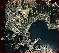
206:is an area in the city of
17:
200:
186:
49:
40:
232:is located at Kurihama.
69:35.226611°N 139.706000°E
34:
244:Kurihama ferry terminal
74:35.226611; 139.706000
141: • Density
294:on January 13, 2015
212:Kanagawa Prefecture
99:Kanagawa Prefecture
65: /
335:Yokosuka, Kanagawa
133: • Total
120: • Total
192:
191:
342:
319:
310:
304:
303:
301:
299:
290:. Archived from
284:
253:
241:
223:opening of Japan
219:Matthew C. Perry
205:
203:
202:
80:
79:
77:
76:
75:
70:
66:
63:
62:
61:
58:
45:
28:
20:Kurihama Station
350:
349:
345:
344:
343:
341:
340:
339:
325:
324:
323:
322:
316:New York Times.
311:
307:
297:
295:
286:
285:
281:
276:
264:
257:
254:
245:
242:
197:
180:久里浜観光協会公式ウェブサイト
73:
71:
67:
64:
59:
56:
54:
52:
51:
36:
33:
26:
23:
12:
11:
5:
348:
346:
338:
337:
327:
326:
321:
320:
318:July 14, 1953,
305:
278:
277:
275:
272:
271:
270:
263:
260:
259:
258:
255:
248:
246:
243:
236:
190:
189:
184:
183:
177:
173:
172:
169:
163:
162:
152:
146:
145:
142:
138:
137:
134:
130:
129:
125:
124:
121:
117:
116:
112:
111:
106:
102:
101:
96:
90:
89:
86:
82:
81:
47:
46:
38:
37:
31:
24:
13:
10:
9:
6:
4:
3:
2:
347:
336:
333:
332:
330:
317:
314:
309:
306:
293:
289:
283:
280:
273:
269:
266:
265:
261:
252:
247:
240:
235:
233:
231:
226:
224:
220:
215:
213:
209:
196:
185:
181:
178:
170:
168:
160:
156:
153:
151:
143:
135:
122:
110:
109:Yokosuka City
107:
100:
97:
95:
87:
78:
60:139°42′21.6″E
50:Coordinates:
48:
44:
29:
21:
16:
315:
308:
296:. Retrieved
292:the original
282:
227:
216:
194:
193:
57:35°13′35.8″N
15:
298:December 9,
72: /
288:"横須賀市推計人口"
274:References
182:(Japanese)
128:Population
94:Prefecture
214:, Japan.
167:Area code
150:Time zone
329:Category
262:See also
208:Yokosuka
195:Kurihama
32:Kurihama
176:Website
85:Country
188:Japan.
136:53,782
155:UTC+9
88:Japan
300:2014
228:The
115:Area
105:City
210:in
201:久里浜
171:046
159:JST
35:久里浜
331::
302:.
204:)
198:(
161:)
157:(
22:.
Text is available under the Creative Commons Attribution-ShareAlike License. Additional terms may apply.