176:
200:
188:
27:
175:
132:
Kyläniemi used to be a peninsula, until the construction of
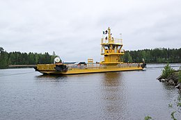
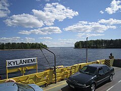
Kutvele canal in the 18nth century turned it to an island. The island can be reached via the road connection at Ruokohlati and via Kyläniemi ferry.
153:
and sand pink flowers were among the first plant species to appear on the island. A variety of plants that can be found includes anemone, sand pansy and
160:
Kyläniemi is considered a significant geological and biological ridge area. It is protected under the national ridge protection program and the
63:
405:
303:
199:
406:"Toimenpidesuunnitelma Taipalsaaren Kyläniemen Natura 2000 –alueella (FI0422005) tilalla Vaiviola (4:128) ja Ahola (4:28)"
379:
277:
255:
435:
229:
187:
129:. Kyläniemi is the 20th largest island in Finland's inland waters, with an area of 23 km.
142:
126:
26:
429:
149:
ridges. Kyläniemi emerged during the second
Salpausselkä ice-marginal formation, and
328:
154:
150:
161:
122:
118:
353:
78:
65:
146:
157:. The island also harbors sparsely wooded coniferous forests.
181:
Kyläsalmi cable ferry. Kutvele canal lies in the background.
141:
The 14 km long island consists of sandy beaches,
104:
94:
57:
45:
40:
224:
222:
220:
8:
19:
25:
18:
216:
171:
7:
164:network of preserved natural sites.
304:"Kyläniemi ice-marginal formation"
125:. It was formed during the second
14:
198:
186:
174:
16:Island in Taipalsaari, Finland
1:
117:is an island on the south of
79:61.30622111°N 28.23516306°E
452:
380:"Ymparisto > Kyläniemi"
278:"Ymparisto > Kyläniemi"
145:, gravelly deltas and end
36:
24:
354:"Kyläniemi (Rastiniemi)"
108:14 km (8.7 mi)
84:61.30622111; 28.23516306
256:"Saarten ja vetten maa"
308:www.outdooractive.com
75: /
21:
436:Islands of Finland
112:
111:
443:
420:
419:
417:
415:
410:
402:
396:
395:
393:
391:
384:www.ymparisto.fi
376:
370:
369:
367:
365:
350:
344:
343:
341:
339:
333:www.kylaniemi.fi
325:
319:
318:
316:
314:
300:
294:
293:
291:
289:
282:www.ymparisto.fi
275:Kyläniemi 3">
273:
267:
266:
264:
262:
252:
246:
245:
243:
241:
230:"Saimaa Geopark"
226:
202:
190:
178:
97:
90:
89:
87:
86:
85:
80:
76:
73:
72:
71:
68:
29:
22:
451:
450:
446:
445:
444:
442:
441:
440:
426:
425:
424:
423:
413:
411:
408:
404:
403:
399:
389:
387:
378:
377:
373:
363:
361:
352:
351:
347:
337:
335:
327:
326:
322:
312:
310:
302:
301:
297:
287:
285:
276:
274:
270:
260:
258:
254:
253:
249:
239:
237:
228:
227:
218:
213:
206:
205:Kyläniemi beach
203:
194:
193:Kyläniemi ferry
191:
182:
179:
170:
139:
95:
83:
81:
77:
74:
69:
66:
64:
62:
61:
52:
50:
32:
31:Kyläniemi ferry
17:
12:
11:
5:
449:
447:
439:
438:
428:
427:
422:
421:
397:
371:
345:
320:
295:
268:
247:
215:
214:
212:
209:
208:
207:
204:
197:
195:
192:
185:
183:
180:
173:
169:
166:
138:
135:
110:
109:
106:
102:
101:
98:
92:
91:
67:61°18′22.396″N
59:
55:
54:
47:
43:
42:
38:
37:
34:
33:
30:
15:
13:
10:
9:
6:
4:
3:
2:
448:
437:
434:
433:
431:
407:
401:
398:
385:
381:
375:
372:
359:
358:Veneilysaimaa
355:
349:
346:
334:
330:
324:
321:
309:
305:
299:
296:
283:
279:
272:
269:
257:
251:
248:
235:
231:
225:
223:
221:
217:
210:
201:
196:
189:
184:
177:
172:
167:
165:
163:
158:
156:
152:
151:pasqueflowers
148:
144:
136:
134:
130:
128:
124:
120:
116:
107:
103:
99:
93:
88:
70:28°14′6.587″E
60:
56:
51:South Karelia
48:
44:
39:
35:
28:
23:
412:. Retrieved
400:
388:. Retrieved
386:(in Finnish)
383:
374:
362:. Retrieved
360:(in Finnish)
357:
348:
336:. Retrieved
332:
323:
311:. Retrieved
307:
298:
286:. Retrieved
284:(in Finnish)
281:
271:
259:. Retrieved
250:
238:. Retrieved
236:(in Finnish)
233:
159:
155:canary grass
140:
131:
127:Salpausselkä
114:
113:
329:"Kyläniemi"
234:Taipalsaari
162:Natura 2000
123:Taipalsaari
119:lake Saimaa
100:Lake Saimaa
96:Adjacent to
82: /
58:Coordinates
49:Taipalsaari
211:References
137:Geography
115:Kyläniemi
41:Geography
20:Kyläniemi
430:Category
414:24 April
390:24 April
364:24 April
338:24 April
313:24 April
288:24 April
261:24 April
240:24 April
143:terraces
46:Location
168:Gallery
147:moraine
53:Finland
105:Length
409:(PDF)
416:2021
392:2021
366:2021
340:2021
315:2021
290:2021
263:2021
242:2021
121:in
432::
382:.
356:.
331:.
306:.
280:.
232:.
219:^
418:.
394:.
368:.
342:.
317:.
292:.
265:.
244:.
Text is available under the Creative Commons Attribution-ShareAlike License. Additional terms may apply.