47:
236:, also called Kaldred Airfield, is located between the holiday home area and Saltbæk Vig. It is owned by Kalundborg Municipality and is used especially by gliders and motor pilots from Kalundborg Flyveklub, which has been based here since 1961, and Polyteknisk Flyvegruppe. The airport has a 700 m (2,300 ft) long asphalt runway as well as take-off play and wire pick-up for use by gliders.
31:
54:
577:
297:
572:
499:
412:
267:
78:
283:
407:
290:
46:
183:
546:
541:
536:
433:
306:
206:
133:
494:
489:
428:
162:
515:
172:
30:
531:
233:
551:
256:
438:
210:
123:
566:
473:
468:
463:
448:
443:
335:
218:
376:
320:
252:
222:
93:
80:
153:
386:
381:
350:
345:
330:
214:
275:
458:
391:
453:
371:
325:
113:
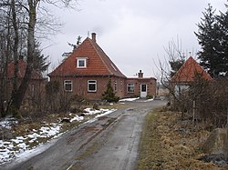
225:. Kaldred is only a few kilometers from Saltbæk Vig and Sejerø Bugt.
179:
158:
340:
279:
213:. It is located 9 km (5.6 mi) southwest of
253:
BY3: Population 1. January, by urban and rural areas
524:
508:
482:
421:
400:
364:
313:
190:
169:
152:
144:
139:
129:
119:
109:
21:
291:
8:
578:Populated places in Kalundborg Municipality
298:
284:
276:
18:
268:Den Store Danske: Kalundborg Flyveplads
245:
189:
151:
138:
108:
73:
39:
27:
221:and 12 km (7.5 mi) east of
168:
143:
128:
118:
7:
217:, 9 km (5.6 mi) north of
573:Cities and towns in Region Zealand
14:
52:
45:
29:
53:
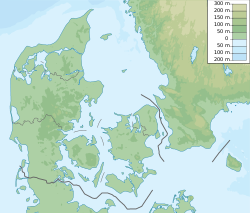
66:Location of Kaldred in Denmark
1:
594:
542:Kalundborg railway station
205:is a holiday home area in
255:The Mobile Statbank from
74:
40:
28:
547:Svebølle railway station
537:Northwest Line (Denmark)
500:Listed buildings (list)
307:Kalundborg Municipality
207:Kalundborg Municipality
495:Kalundborg Transmitter
171: • Summer (
94:55.70111°N 11.26417°E
516:Kalundborg Gymnasium
365:Geography and nature
532:Kalundborg Airfield
490:Asnæs Power Station
234:Kalundborg Airfield
90: /
552:Port of Kalundborg
408:Church of Our Lady
314:Towns and villages
257:Statistics Denmark
145: • Total
99:55.70111; 11.26417
560:
559:
200:
199:
585:
300:
293:
286:
277:
270:
265:
259:
250:
176:
105:
104:
102:
101:
100:
95:
91:
88:
87:
86:
83:
56:
55:
49:
33:
19:
16:Place in Denmark
593:
592:
588:
587:
586:
584:
583:
582:
563:
562:
561:
556:
520:
504:
483:Other landmarks
478:
417:
413:Churches (list)
396:
360:
309:
304:
274:
273:
266:
262:
251:
247:
242:
231:
196:
170:
98:
96:
92:
89:
84:
81:
79:
77:
76:
70:
69:
68:
67:
64:
63:
62:
61:
57:
36:
35:Kaldred Station
24:
17:
12:
11:
5:
591:
589:
581:
580:
575:
565:
564:
558:
557:
555:
554:
549:
544:
539:
534:
528:
526:
522:
521:
519:
518:
512:
510:
506:
505:
503:
502:
497:
492:
486:
484:
480:
479:
477:
476:
471:
466:
461:
456:
451:
446:
441:
436:
431:
425:
423:
419:
418:
416:
415:
410:
404:
402:
398:
397:
395:
394:
389:
384:
379:
374:
368:
366:
362:
361:
359:
358:
353:
348:
343:
338:
333:
328:
323:
317:
315:
311:
310:
305:
303:
302:
295:
288:
280:
272:
271:
260:
244:
243:
241:
238:
230:
227:
211:Region Zealand
198:
197:
194:
192:
188:
187:
177:
167:
166:
156:
150:
149:
146:
142:
141:
137:
136:
131:
127:
126:
124:Region Zealand
121:
117:
116:
111:
107:
106:
72:
71:
65:
59:
58:
51:
50:
44:
43:
42:
41:
38:
37:
34:
26:
25:
22:
15:
13:
10:
9:
6:
4:
3:
2:
590:
579:
576:
574:
571:
570:
568:
553:
550:
548:
545:
543:
540:
538:
535:
533:
530:
529:
527:
523:
517:
514:
513:
511:
507:
501:
498:
496:
493:
491:
488:
487:
485:
481:
475:
474:Vesterbygaard
472:
470:
467:
465:
462:
460:
457:
455:
452:
450:
447:
445:
442:
440:
437:
435:
432:
430:
427:
426:
424:
420:
414:
411:
409:
406:
405:
403:
399:
393:
390:
388:
385:
383:
380:
378:
375:
373:
370:
369:
367:
363:
357:
354:
352:
349:
347:
344:
342:
339:
337:
334:
332:
329:
327:
324:
322:
319:
318:
316:
312:
308:
301:
296:
294:
289:
287:
282:
281:
278:
269:
264:
261:
258:
254:
249:
246:
239:
237:
235:
228:
226:
224:
220:
216:
212:
208:
204:
193:
185:
181:
178:
174:
164:
160:
157:
155:
147:
135:
132:
125:
122:
115:
112:
103:
75:Coordinates:
48:
32:
20:
439:Birkendegård
422:Manor houses
355:
263:
248:
232:
202:
201:
191:Postal codes
130:Municipality
469:Selchausdal
464:Lerchenborg
449:Frihedslund
97: /
567:Categories
321:Kalundborg
240:References
223:Kalundborg
140:Population
134:Kalundborg
85:11°15′51″E
525:Transport
509:Educatuib
434:Algestrup
229:Transport
209:, in the
154:Time zone
82:55°42′4″N
459:Kragerup
444:Bødstrup
401:Churches
336:Svebølle
219:Svebølle
454:Kattrup
429:Aagaard
377:Nekselø
372:Musholm
356:Kaldred
203:Kaldred
114:Denmark
110:Country
60:Kaldred
23:Kaldred
387:Sejerø
382:Reersø
351:Reersø
346:Havnsø
331:Gørlev
215:Havnsø
120:Region
392:Tissø
180:UTC+2
159:UTC+1
341:Ubby
326:Høng
195:4593
184:CEST
173:DST
163:CET
148:405
569::
299:e
292:t
285:v
186:)
182:(
175:)
165:)
161:(
Text is available under the Creative Commons Attribution-ShareAlike License. Additional terms may apply.