135:
20:
155:
348:
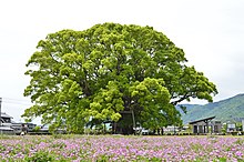
112:. The tree is approximately 1500 years old, and stretches 33.6 m (110 ft) across, and about 30 m (98 ft) high. It was heavily damaged in typhoons in 1997 and 2004. A large hollow, with a diameter of 4.5 m (15 ft), exists inside the tree. This hollow was a favourite resting place for homeless men in Kagoshima until a locked door was installed in April 2000.
95:
270:
Nche, LA; Hasegawa, T; Aka, FT; Kobayashi, T; Németh, K; Asaah, AN; Kaneda, Y; Nishihara, A; Bate-Tibang, EE; Lebga, AK; Tiabou, AF (2021). "Lithostratigraphy and geochemistry of Aojiki volcano and
Sumiyoshiike and Yonemaru maars, Kamo Volcanic Field (Southern Kyushu), Japan".
146:. To the north are the heights of the Aojiki volcano and hot springs near the plain of Yonemaru. The lake of Sumiyoshiike (Sumiyoshi pond) is to the former town's north-east which is north-west of the centre of the Aira conurbation.
404:
142:
The former town is in a valley drained by the Gamou river which flows to the south-east through the conurbation of Aira and into the north-western portion of
385:
312:
134:
138:
Relief map centred on Kamō. Aojiki volcano is the high relief in centre, Yonemaru maar is to its west, with
Sumiyoshi pond to its east.
414:
195:
378:
76:
371:
115:
The tree, fondly referred to as Ōkusu (大楠, great camphor) by locals, is located on the grounds of
Hachiman Jinja, a
167:
409:
174:
of
Yonemaru and Sumiyoshiike as well as the volcanic hill of Aojiki. The volcanic vents are north-west of the
84:
50:
46:
249:
54:
104:
19:
69:
80:
355:
280:
88:
223:
199:
154:
116:
398:
284:
143:
175:
347:
94:
65:
327:
314:
123:
163:
126:
called Donto
Matsuri takes place on the grounds of Hachiman Jinja.
153:
133:
109:
93:
58:
171:
301:
158:
Sumiyoshi pond maar, Aira city, Kagoshima prefecture, Japan
16:
Former town in Aira
District, Kagoshima Prefecture, Japan
359:
72:
of 89.94 persons per km. The total area was 81.29 km.
91:. Aira District will be left with one municipality.
224:"Great Kamou Okusu (Camphor tree) (日本一の巨樹 蒲生の大クス)"
75:On March 23, 2010, Kamō, along with the towns of
405:Dissolved municipalities of Kagoshima Prefecture
354:This Kagoshima Prefecture location article is a
102:Kamō is home to the oldest Camphor laurel tree (
38:
273:Journal of Volcanology and Geothermal Research
32:
379:
8:
23:The location of Kamo in Kagoshima Prefecture
386:
372:
18:
218:
216:
187:
162:To the north of the town/suburb is the
244:
242:
240:
64:As of 2003, the town had an estimated
7:
344:
342:
358:. You can help Knowledge (XXG) by
14:
346:
285:10.1016/j.jvolgeores.2020.107170
1:
87:), was merged to create the
250:"Kamo's Great Camphor Tree"
39:
431:
341:
302:Aira City official website
168:monogenetic volcanic field
415:Kagoshima geography stubs
122:Every November an autumn
33:
196:"市町村合併情報 鹿児島県 <国土地理協会>"
328:31.77667°N 130.54917°E
159:
139:
99:
24:
157:
137:
97:
22:
55:Kagoshima Prefecture
333:31.77667; 130.54917
324: /
105:Cinnamomum camphora
160:
140:
100:
25:
367:
366:
68:of 7,311 and the
422:
388:
381:
374:
350:
343:
339:
338:
336:
335:
334:
329:
325:
322:
321:
320:
317:
306:
289:
288:
267:
261:
260:
258:
256:
246:
235:
234:
232:
230:
220:
211:
210:
208:
207:
198:. Archived from
192:
44:
42:
36:
35:
430:
429:
425:
424:
423:
421:
420:
419:
410:Aira, Kagoshima
395:
394:
393:
392:
332:
330:
326:
323:
318:
315:
313:
311:
310:
304:
298:
293:
292:
269:
268:
264:
254:
252:
248:
247:
238:
228:
226:
222:
221:
214:
205:
203:
194:
193:
189:
184:
152:
132:
30:
17:
12:
11:
5:
428:
426:
418:
417:
412:
407:
397:
396:
391:
390:
383:
376:
368:
365:
364:
351:
308:
307:
297:
296:External links
294:
291:
290:
262:
236:
212:
186:
185:
183:
180:
151:
148:
131:
128:
15:
13:
10:
9:
6:
4:
3:
2:
427:
416:
413:
411:
408:
406:
403:
402:
400:
389:
384:
382:
377:
375:
370:
369:
363:
361:
357:
352:
349:
345:
340:
337:
305:(in Japanese)
303:
300:
299:
295:
286:
282:
278:
274:
266:
263:
251:
245:
243:
241:
237:
225:
219:
217:
213:
202:on 2008-04-18
201:
197:
191:
188:
181:
179:
177:
173:
170:with the two
169:
165:
156:
149:
147:
145:
144:Kagoshima Bay
136:
129:
127:
125:
120:
118:
117:shinto shrine
113:
111:
107:
106:
98:Ōkusu at Kamō
96:
92:
90:
86:
85:Aira District
82:
79:(former) and
78:
73:
71:
67:
62:
60:
56:
52:
51:Aira District
48:
41:
29:
21:
360:expanding it
353:
309:
276:
272:
265:
253:. Retrieved
227:. Retrieved
204:. Retrieved
200:the original
190:
176:Aira Caldera
161:
141:
121:
114:
103:
101:
89:city of Aira
74:
63:
27:
26:
331: /
319:130°32′57″E
255:18 November
229:18 November
49:located in
399:Categories
316:31°46′36″N
279:(107170).
206:2008-09-13
182:References
83:(all from
66:population
130:Geography
164:basaltic
124:festival
40:Kamō-chō
150:Geology
70:density
81:Kajiki
45:was a
172:maars
166:Kamo
110:Japan
108:) in
59:Japan
356:stub
257:2023
231:2023
77:Aira
47:town
28:Kamō
281:doi
277:412
34:蒲生町
401::
275:.
239:^
215:^
178:.
119:.
61:.
57:,
53:,
37:,
387:e
380:t
373:v
362:.
287:.
283::
259:.
233:.
209:.
43:)
31:(
Text is available under the Creative Commons Attribution-ShareAlike License. Additional terms may apply.